National Register of Historic Places listings in Bastrop County, Texas

This is a list of the National Register of Historic Places listings in Bastrop County, Texas.
This is intended to be a complete list of properties and districts listed on the National Register of Historic Places in Bastrop County, Texas. There are five districts, including one National Historic Landmark district, and 95 individual properties listed on the National Register in the county. An additional site was formerly listed. One individually listed property is a State Antiquities Landmark and contains two Recorded Texas Historic Landmarks. Twenty-three other properties and numerous sites within three districts are also Recorded Texas Historic Landmarks.
- This National Park Service list is complete through NPS recent listings posted October 11, 2018.[1]
Current listings
The locations of National Register properties and districts may be seen in a mapping service provided.[2]
| [3] | Name on the Register[4] | Image | Date listed[5] | Location | City or town | Description |
|---|---|---|---|---|---|---|
| 1 | Allen-Bell House |  |
January 25, 1971 (#71000919) |
1408 Church St. 30°06′57″N 97°19′18″W / 30.115786°N 97.321731°W |
Bastrop | Recorded Texas Historic Landmark |
| 2 | August Baron House |  |
December 22, 1978 (#78003277) |
1707 Pecan St. 30°07′07″N 97°19′03″W / 30.11872°N 97.31751°W |
Bastrop | Historic and Architectural Resources of Bastrop MRA |
| 3 | Ed Bastain-Haralson House |  |
December 22, 1978 (#78003350) |
1006 Chestnut St. 30°06′39″N 97°18′57″W / 30.110819°N 97.315794°W |
Bastrop | Recorded Texas Historic Landmark; Historic and Architectural Resources of Bastrop MRA |
| 4 | Bastrop Commercial District |  |
December 22, 1978 (#78003262) |
Roughly bounded by Church, Water, Spring, and Walnut Sts. 30°06′38″N 97°19′12″W / 30.110556°N 97.32°W |
Bastrop | Includes Recorded Texas Historic Landmarks; Historic and Architectural Resources of Bastrop MRA; 32 buildings |
| 5 | Bastrop County Courthouse and Jail Complex | 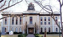 |
November 20, 1975 (#75001947) |
Bounded by Pine, Walnut, Pecan, and Water Sts. 30°06′33″N 97°19′05″W / 30.109167°N 97.318056°W |
Bastrop | State Antiquities Landmark, includes Recorded Texas Historic Landmarks; Historic and Architectural Resources of Bastrop MRA |
| 6 | Bastrop State Park | 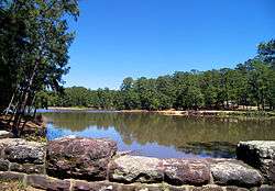 |
September 25, 1997 (#97001242) |
East of Bastrop, bet. TX 21 & 71 30°06′31″N 97°16′55″W / 30.108611°N 97.281944°W |
Bastrop | |
| 7 | Judge R. Batts House | December 22, 1978 (#78003336) |
609 Pecan St. 30°06′26″N 97°19′02″W / 30.10718°N 97.31733°W |
Bastrop | Historic and Architectural Resources of Bastrop MRA; a church now stands at the site. | |
| 8 | S. L. Brannon House |  |
December 22, 1978 (#78003264) |
1301 Main St. 30°06′50″N 97°19′11″W / 30.11391°N 97.31977°W |
Bastrop | Historic and Architectural Resources of Bastrop MRA |
| 9 | R. J. Brieger House |  |
December 22, 1978 (#78003278) |
1508 Hill St. 30°07′00″N 97°18′55″W / 30.11669°N 97.31539°W |
Bastrop | Recorded Texas Historic Landmark; Historic and Architectural Resources of Bastrop MRA |
| 10 | Jennie Brooks House |  |
December 22, 1978 (#78003317) |
1009 Walnut St. 30°06′30″N 97°18′55″W / 30.10831°N 97.31524°W |
Bastrop | Historic and Architectural Resources of Bastrop MRA |
| 11 | Brooks-Wilbarger House |  |
December 22, 1978 (#78003269) |
1403 Main St. 30°06′55″N 97°19′12″W / 30.11516°N 97.31987°W |
Bastrop | Recorded Texas Historic Landmark; Historic and Architectural Resources of Bastrop MRA |
| 12 | J. C. Buchanan House |  |
December 22, 1978 (#78003326) |
1010 Pecan St. 30°06′41″N 97°19′04″W / 30.11144°N 97.31786°W |
Bastrop | Historic and Architectural Resources of Bastrop MRA; now the Pecan Street Inn |
| 13 | Casino Hall |  |
December 22, 1978 (#78003291) |
NE corner of Farm and Fayette 30°06′47″N 97°18′45″W / 30.112992°N 97.312408°W |
Bastrop | Historic and Architectural Resources of Bastrop MRA |
| 14 | Colorado River Bridge at Bastrop | 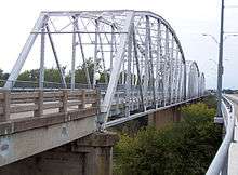 |
July 19, 1990 (#90001031) |
State Loop 150 over the Colorado River 30°06′36″N 97°19′21″W / 30.110081°N 97.322517°W |
Bastrop | Historic and Architectural Resources of Bastrop MRA |
| 15 | H. B. Combs House | 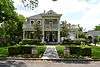 |
December 22, 1978 (#78003294) |
1208 Church St. 30°06′49″N 97°19′18″W / 30.11371°N 97.32155°W |
Bastrop | Historic and Architectural Resources of Bastrop MRA |
| 16 | John Cornelson House | 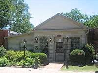 |
December 22, 1978 (#78003301) |
702 Main St. 30°06′26″N 97°19′11″W / 30.10715°N 97.31976°W |
Bastrop | Recorded Texas Historic Landmark; Historic and Architectural Resources of Bastrop MRA; now the Bastrop County Historical Society Museum |
| 17 | Crocheron-McDowall House | 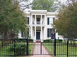 |
April 20, 1978 (#78003357) |
1502 Wilson St. 30°06′58″N 97°19′22″W / 30.11604°N 97.32278°W |
Bastrop | Recorded Texas Historic Landmark; Historic and Architectural Resources of Bastrop MRA |
| 18 | J. T. Crysup House |  |
December 22, 1978 (#78003274) |
1607 Main St. 30°07′03″N 97°19′11″W / 30.11762°N 97.31979°W |
Bastrop | Historic and Architectural Resources of Bastrop MRA |
| 19 | George W. Davis House |  |
December 22, 1978 (#78003343) |
1010 Chestnut St. 30°06′39″N 97°18′55″W / 30.110839°N 97.315383°W |
Bastrop | Historic and Architectural Resources of Bastrop MRA |
| 20 | Dawson House |  |
December 22, 1978 (#78003351) |
1002 Chestnut St. 30°06′39″N 97°18′58″W / 30.1108°N 97.316089°W |
Bastrop | Historic and Architectural Resources of Bastrop MRA |
| 21 | Mary Duval House |  |
December 22, 1978 (#78003268) |
1502 Pecan St. 30°06′58″N 97°19′04″W / 30.1160°N 97.3179°W |
Bastrop | Historic and Architectural Resources of Bastrop MRA |
| 22 | Elgin Commercial Historic District | 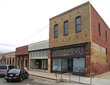 |
February 16, 1996 (#96000024) |
Roughly, along Main St., Ave. C, Central and Depot Aves. and 1st and 2nd Sts. 30°20′52″N 97°22′14″W / 30.347778°N 97.370556°W |
Elgin | Includes Recorded Texas Historic Landmark |
| 23 | Elzner House | 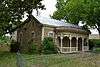 |
December 22, 1978 (#78003302) |
800 Main St. 30°06′31″N 97°19′12″W / 30.10867°N 97.32013°W |
Bastrop | Historic and Architectural Resources of Bastrop MRA; Recorded Texas Historic Landmark |
| 24 | August Elzner House |  |
December 22, 1978 (#78003273) |
1701 Main St. 30°07′05″N 97°19′11″W / 30.11807°N 97.31982°W |
Bastrop | Historic and Architectural Resources of Bastrop MRA |
| 25 | Prince Elzner House |  |
December 22, 1978 (#78003283) |
1303 Pecan St. 30°06′51″N 97°19′02″W / 30.11416°N 97.31731°W |
Bastrop | Historic and Architectural Resources of Bastrop MRA |
| 26 | Erhard House |  |
December 22, 1978 (#78003280) |
907 Cedar St. 30°07′02″N 97°19′03″W / 30.117133°N 97.317403°W |
Bastrop | Historic and Architectural Resources of Bastrop MRA |
| 27 | A. A. Erhard House |  |
December 22, 1978 (#78003329) |
1106 Pecan St. 30°06′44″N 97°19′04″W / 30.11236°N 97.31773°W |
Bastrop | Historic and Architectural Resources of Bastrop MRA |
| 28 | Adolph A. Erhard House |  |
December 22, 1978 (#78003284) |
1205 Pecan St. 30°06′48″N 97°19′02″W / 30.11341°N 97.31724°W |
Bastrop | Recorded Texas Historic Landmark; Historic and Architectural Resources of Bastrop MRA |
| 29 | E. C. Erhard House |  |
December 22, 1978 (#78003279) |
1507 Pecan St. 30°07′00″N 97°19′02″W / 30.11663°N 97.31734°W |
Bastrop | Historic and Architectural Resources of Bastrop MRA |
| 30 | Farm House | December 22, 1978 (#78003334) |
End of Pecan St. 30°06′03″N 97°18′56″W / 30.100727°N 97.315447°W |
Bastrop | Historic and Architectural Resources of Bastrop MRA | |
| 31 | Fowler House |  |
December 22, 1978 (#78003321) |
1404 Wilson St. 30°06′55″N 97°19′22″W / 30.11516°N 97.32279°W |
Bastrop | Recorded Texas Historic Landmark; Historic and Architectural Resources of Bastrop MRA |
| 32 | Fowler-Jenkins House |  |
December 22, 1978 (#78003263) |
1302 Pecan St. 30°06′50″N 97°19′04″W / 30.11400°N 97.31787°W |
Bastrop | Recorded Texas Historic Landmark; Historic and Architectural Resources of Bastrop MRA |
| 33 | P. A. Fry House | December 22, 1978 (#78003337) |
1403 Emile St. 30°06′22″N 97°18′38″W / 30.106212°N 97.310617°W |
Bastrop | Historic and Architectural Resources of Bastrop MRA; house moved from original location to current location across from Emilie School. | |
| 34 | Rufus A. Green House |  |
December 22, 1978 (#78003347) |
1501 Church St. 30°06′58″N 97°19′16″W / 30.11607°N 97.32100°W |
Bastrop | Historic and Architectural Resources of Bastrop MRA |
| 35 | Griesenbeck House |  |
December 22, 1978 (#78003349) |
805 Pecan St. 30°06′33″N 97°19′02″W / 30.10912°N 97.31721°W |
Bastrop | Historic and Architectural Resources of Bastrop MRA |
| 36 | Alf Griesenbeck House |  |
December 22, 1978 (#78003282) |
1302 Hill St. 30°06′51″N 97°18′56″W / 30.11410°N 97.31543°W |
Bastrop | Historic and Architectural Resources of Bastrop MRA |
| 37 | Erna Griesenbeck House |  |
December 22, 1978 (#78003338) |
908 Pine St. 30°06′35″N 97°19′00″W / 30.10975°N 97.316803°W |
Bastrop | Historic and Architectural Resources of Bastrop MRA |
| 38 | R. J. Griesenbeck House |  |
December 22, 1978 (#78003308) |
1005 Chestnut St. 30°06′37″N 97°18′57″W / 30.110322°N 97.315797°W |
Bastrop | Historic and Architectural Resources of Bastrop MRA |
| 39 | Dr. C. A. Grimes House |  |
December 22, 1978 (#78003355) |
1201 Farm St. 30°06′45″N 97°18′49″W / 30.11263°N 97.31367°W |
Bastrop | Historic and Architectural Resources of Bastrop MRA |
| 40 | Hall-Sayers-Perkins House |  |
December 22, 1978 (#78003293) |
1307 Church St. 30°06′52″N 97°19′16″W / 30.11450°N 97.32101°W |
Bastrop | Recorded Texas Historic Landmark; Historic and Architectural Resources of Bastrop MRA |
| 41 | Eugene Harlson House |  |
December 22, 1978 (#78003344) |
803 Jefferson St. 30°06′32″N 97°18′58″W / 30.10888°N 97.31601°W |
Bastrop | Historic and Architectural Resources of Bastrop MRA |
| 42 | Emelia Hasler House |  |
December 22, 1978 (#78003307) |
1004 Pine St. 30°06′35″N 97°18′57″W / 30.109717°N 97.315794°W |
Bastrop | Historic and Architectural Resources of Bastrop MRA |
| 43 | T. A. Hasler House |  |
December 22, 1978 (#78003330) |
1109 Pecan 30°06′45″N 97°19′02″W / 30.11258°N 97.31728°W |
Bastrop | Historic and Architectural Resources of Bastrop MRA |
| 44 | Abraham Wiley Hill House |  |
March 11, 1971 (#71000920) |
5 mi (8.0 km). SW of Hills Prairie 30°02′53″N 97°18′28″W / 30.048056°N 97.307742°W |
Hills Prairie | Recorded Texas Historic Landmark |
| 45 | Hopewell School |  |
June 8, 2015 (#15000334) |
690 TX 21 W 30°05′55″N 97°27′41″W / 30.098644°N 97.461267°W |
Cedar Creek | Historic and Architectural Resources Associated with the Rosenwald School Program in Texas |
| 46 | House at 1002 Pine |  |
December 22, 1978 (#78003304) |
1002 Pine St. 30°06′35″N 97°18′58″W / 30.10982°N 97.31608°W |
Bastrop | Historic and Architectural Resources of Bastrop MRA |
| 47 | House at 1002 Walnut |  |
December 22, 1978 (#78003303) |
1002 Walnut St. 30°06′31″N 97°18′58″W / 30.10867°N 97.31602°W |
Bastrop | Historic and Architectural Resources of Bastrop MRA |
| 48 | House at 1105 Hill |  |
December 22, 1978 (#78003312) |
1105 Hill St. 30°06′45″N 97°18′54″W / 30.11237°N 97.31488°W |
Bastrop | Historic and Architectural Resources of Bastrop MRA |
| 49 | House at 1108 Hill |  |
December 22, 1978 (#78003306) |
1108 Hill St. 30°06′45″N 97°18′55″W / 30.11257°N 97.31534°W |
Bastrop | Historic and Architectural Resources of Bastrop MRA |
| 50 | House at 1301 Hill |  |
December 22, 1978 (#78003286) |
1301 Hill St. 30°06′51″N 97°18′53″W / 30.11406°N 97.31482°W |
Bastrop | Historic and Architectural Resources of Bastrop MRA |
| 51 | House at 1308 Fayette |  |
December 22, 1978 (#78003285) |
1308 Fayette St. 30°06′53″N 97°18′45″W / 30.11472°N 97.31237°W |
Bastrop | Historic and Architectural Resources of Bastrop MRA |
| 52 | House at 1316 Farm |  |
December 22, 1978 (#78003290) |
1316 Farm St. 30°06′47″N 97°18′44″W / 30.11299°N 97.31210°W |
Bastrop | Historic and Architectural Resources of Bastrop MRA |
| 53 | House at 311 Pecan |  |
December 22, 1978 (#78003327) |
311 Pecan St. 30°06′14″N 97°19′02″W / 30.10390°N 97.31719°W |
Bastrop | Historic and Architectural Resources of Bastrop MRA |
| 54 | House at 604 Elm |  |
December 22, 1978 (#78003310) |
604 Elm St. 30°07′09″N 97°19′16″W / 30.119081°N 97.3210°W |
Bastrop | Historic and Architectural Resources of Bastrop MRA |
| 55 | House at 806 Jefferson |  |
December 22, 1978 (#78003342) |
806 Jefferson St. 30°06′32″N 97°18′59″W / 30.10897°N 97.31644°W |
Bastrop | Recorded Texas Historic Landmark; Historic and Architectural Resources of Bastrop MRA |
| 56 | Houses at 703 and 704 Austin | 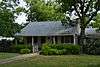 |
December 22, 1978 (#78003316) |
703 and 704 Austin 30°06′27″N 97°19′09″W / 30.107528°N 97.3192°W |
Bastrop | Historic and Architectural Resources of Bastrop MRA |
| 57 | Hubbard-Trigg House | 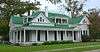 |
December 22, 1978 (#78003266) |
1508 Pecan St. 30°07′00″N 97°19′04″W / 30.11664°N 97.31790°W |
Bastrop | Recorded Texas Historic Landmark; Historic and Architectural Resources of Bastrop MRA |
| 58 | Iron Bridge | 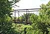 |
December 22, 1978 (#78003292) |
Over Piney Creek on Main St. 30°07′53″N 97°19′16″W / 30.13141°N 97.3210°W |
Bastrop | Historic and Architectural Resources of Bastrop MRA |
| 59 | Jenkins House | 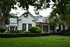 |
December 22, 1978 (#78003345) |
801 Pecan St. 30°06′31″N 97°19′02″W / 30.10873°N 97.31722°W |
Bastrop | Recorded Texas Historic Landmark; Historic and Architectural Resources of Bastrop MRA; aka S. C. Jenkins House |
| 60 | Jenkins House |  |
December 22, 1978 (#78003299) |
1710 Main St. 30°07′08″N 97°19′14″W / 30.118819°N 97.320417°W |
Bastrop | Recorded Texas Historic Landmark; Historic and Architectural Resources of Bastrop MRA |
| 61 | George Washington Jones House | December 22, 1978 (#78003335) |
Martin Luther King Jr. Dr. and Mill St. (formerly Fayette St. and Mill St.) 30°06′08″N 97°18′41″W / 30.102194°N 97.311392°W |
Bastrop | Historic and Architectural Resources of Bastrop MRA | |
| 62 | Oliver P. Jones House |  |
December 22, 1978 (#78003331) |
1009 Pecan St. 30°06′41″N 97°19′02″W / 30.11152°N 97.31731°W |
Bastrop | Historic and Architectural Resources of Bastrop MRA |
| 63 | Jung Storage Building |  |
December 22, 1978 (#78003323) |
801 Emilie (corner of Emilie and Water) 30°06′23″N 97°19′07″W / 30.10627°N 97.31857°W |
Bastrop | Historic and Architectural Resources of Bastrop MRA |
| 64 | Alf Jung House |  |
December 22, 1978 (#78003322) |
508 Pecan St. 30°06′22″N 97°19′04″W / 30.10617°N 97.31770°W |
Bastrop | Historic and Architectural Resources of Bastrop MRA |
| 65 | Joe Jung House |  |
December 22, 1978 (#78003333) |
909 Pecan St. 30°06′38″N 97°19′02″W / 30.11042°N 97.31735°W |
Bastrop | Recorded Texas Historic Landmark; Historic and Architectural Resources of Bastrop MRA |
| 66 | Kerr Community Center |  |
December 22, 1978 (#78003339) |
1308 Walnut 30°06′31″N 97°18′43″W / 30.108586°N 97.312025°W |
Bastrop | Historic and Architectural Resources of Bastrop MRA |
| 67 | Beverly and Lula Kerr House |  |
December 22, 1978 (#78003356) |
1305 Pine St. 30°06′34″N 97°18′43″W / 30.10936°N 97.31182°W |
Bastrop | Historic and Architectural Resources of Bastrop MRA |
| 68 | Kleinert House | December 22, 1978 (#78003288) |
1801 Hill St. 30°07′09″N 97°18′55″W / 30.11914°N 97.31530°W |
Bastrop | Historic and Architectural Resources of Bastrop MRA | |
| 69 | Kohler-McPhaul House | December 22, 1978 (#78003275) |
1901 Pecan St. 30°07′17″N 97°19′03″W / 30.121489°N 97.317561°W |
Bastrop | Historic and Architectural Resources of Bastrop MRA | |
| 70 | Lower Elgin Road Bridge at Wilbarger Creek | 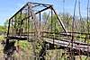 |
April 10, 2017 (#100000860) |
County Road 55 at Wilbarger Creek 30°13′21″N 97°24′34″W / 30.222559°N 97.409355°W |
Utley | |
| 71 | H. P. Luckett House | 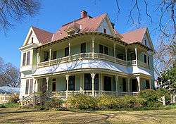 |
December 22, 1978 (#78003296) |
1402 Church St. 30°06′54″N 97°19′18″W / 30.11503°N 97.32160°W |
Bastrop | Recorded Texas Historic Landmark; Historic and Architectural Resources of Bastrop MRA |
| 72 | Bartholomew Manlove House | 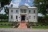 |
December 22, 1978 (#78003311) |
502 Elm St. 30°07′09″N 97°19′20″W / 30.119089°N 97.322361°W |
Bastrop | Recorded Texas Historic Landmark |
| 73 | Powell C. Maynard House |  |
December 22, 1978 (#78003267) |
1408 Pecan St. 30°06′56″N 97°19′04″W / 30.1156°N 97.3179°W |
Bastrop | Historic and Architectural Resources of Bastrop MRA |
| 74 | W. E. Maynard House |  |
December 22, 1978 (#78003281) |
1310 Hill St. 30°06′54″N 97°18′55″W / 30.11495°N 97.31540°W |
Bastrop | Historic and Architectural Resources of Bastrop MRA |
| 75 | Harriet and Charlie McNeil House | December 22, 1978 (#78003276) |
1805 Pecan St. 30°07′08″N 97°19′03″W / 30.119014°N 97.317439°W |
Bastrop | Historic and Architectural Resources of Bastrop MRA | |
| 76 | Marcellus McNeil House | December 22, 1978 (#78003298) |
1809 Wilson St. 30°07′14″N 97°19′21″W / 30.12043°N 97.32247°W |
Bastrop | Historic and Architectural Resources of Bastrop MRA; demolished, new house built at listed address. | |
| 77 | Willis Miley House |  |
December 22, 1978 (#78003289) |
1320 Farm St. 30°06′47″N 97°18′37″W / 30.113075°N 97.31036°W |
Bastrop | Historic and Architectural Resources of Bastrop MRA |
| 78 | MKT Depot | December 22, 1978 (#78003354) |
NW Chestnut and Fayette 30°06′40″N 97°18′46″W / 30.1112°N 97.312783°W |
Bastrop | Historic and Architectural Resources of Bastrop MRA | |
| 79 | Old Bastrop Co. Pavilion |  |
December 22, 1978 (#78003287) |
1800 block of Hawthorne 30°07′16″N 97°18′47″W / 30.121208°N 97.312983°W |
Bastrop | Historic and Architectural Resources of Bastrop MRA |
| 80 | L. W. Olive House |  |
December 22, 1978 (#78003270) |
1507 Main St. 30°07′00″N 97°19′11″W / 30.11662°N 97.31981°W |
Bastrop | Historic and Architectural Resources of Bastrop MRA |
| 81 | Elbert S. Orgain House |  |
December 22, 1978 (#78003300) |
1704 Main St. 30°07′06″N 97°19′14″W / 30.118222°N 97.320483°W |
Bastrop | Historic and Architectural Resources of Bastrop MRA |
| 82 | Sarah Jane Orgain House |  |
December 22, 1978 (#78003309) |
602 Cedar St. 30°07′00″N 97°19′16″W / 30.116578°N 97.321006°W |
Bastrop | Historic and Architectural Resources of Bastrop MRA |
| 83 | Paul D. Page House |  |
December 22, 1978 (#78003272) |
1702 Pecan St. 30°07′05″N 97°19′05″W / 30.118147°N 97.318047°W |
Bastrop | Historic and Architectural Resources of Bastrop MRA |
| 84 | J. H. Pearcy House |  |
December 22, 1978 (#78003271) |
1602 Pecan St. 30°07′02″N 97°19′05″W / 30.117139°N 97.317986°W |
Bastrop | Historic and Architectural Resources of Bastrop MRA |
| 85 | Phieffer House |  |
December 22, 1978 (#78003314) |
1802 Main St. 30°07′09″N 97°19′14″W / 30.119125°N 97.320486°W |
Bastrop | Recorded Texas Historic Landmark; Historic and Architectural Resources of Bastrop MRA |
| 86 | J. W. Pledger House |  |
December 22, 1978 (#78003318) |
1704 Wilson St. 30°07′06″N 97°19′22″W / 30.118317°N 97.322861°W |
Bastrop | Historic and Architectural Resources of Bastrop MRA |
| 87 | Ploeger-Kerr-White House | December 22, 1978 (#78003346) |
806 Martin Luther King Jr. Dr (formerly Marion St.) 30°06′33″N 97°18′41″W / 30.10914°N 97.31152°W |
Bastrop | Historic and Architectural Resources of Bastrop MRA | |
| 88 | Rabensburg House |  |
December 22, 1978 (#78003348) |
707 Pecan St. 30°06′30″N 97°19′02″W / 30.10834°N 97.31725°W |
Bastrop | Historic and Architectural Resources of Bastrop MRA |
| 89 | Mrs. William R. Reding House |  |
December 22, 1978 (#78003340) |
901 Pecan St. 30°06′35″N 97°19′02″W / 30.10975°N 97.31734°W |
Bastrop | Historic and Architectural Resources of Bastrop MRA |
| 90 | Gov. Joseph Sayers House |  |
December 22, 1978 (#78003297) |
1703 Wilson St. 30°07′04″N 97°19′20″W / 30.11790°N 97.32233°W |
Bastrop | Recorded Texas Historic Landmark; Historic and Architectural Resources of Bastrop MRA |
| 91 | W. F. Schaeffer House |  |
December 22, 1978 (#78003324) |
608 Pecan St. 30°06′26″N 97°19′04″W / 30.10718°N 97.31769°W |
Bastrop | Historic and Architectural Resources of Bastrop MRA |
| 92 | Smithville Commercial Historic District | 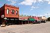 |
June 17, 1982 (#82004489) |
2nd, 3rd, and Main Sts. 30°00′28″N 97°09′35″W / 30.007778°N 97.159722°W |
Smithville | 36 buildings |
| 93 | Smithville Residential Historic District |  |
November 29, 1995 (#95001395) |
Roughly bounded by Cleveland, First, Mills, N. 9th, Burleson, Colorado, and the Colorado R. 30°00′33″N 97°09′23″W / 30.009167°N 97.156389°W |
Smithville | Includes Recorded Texas Historic Landmarks; 191 buildings |
| 94 | Richard Starcke House |  |
December 22, 1978 (#78003315) |
710 Water St. 30°06′30″N 97°19′08″W / 30.10830°N 97.31894°W |
Bastrop | Historic and Architectural Resources of Bastrop MRA |
| 95 | Richard Starcke House |  |
December 22, 1978 (#78003328) |
703 Main St. 30°06′28″N 97°19′10″W / 30.10784°N 97.31946°W |
Bastrop | Historic and Architectural Resources of Bastrop MRA |
| 96 | Campbell Taylor and Greenleaf Fisk House |  |
December 22, 1978 (#78003353) |
1005 Hill St. 30°06′41″N 97°18′54″W / 30.11134°N 97.31490°W |
Bastrop | Recorded Texas Historic Landmark; Historic and Architectural Resources of Bastrop MRA |
| 97 | Waugh House |  |
December 22, 1978 (#78003313) |
1801 Main St. 30°07′09″N 97°19′12″W / 30.119114°N 97.319928°W |
Bastrop | Historic and Architectural Resources of Bastrop MRA |
| 98 | White House |  |
December 22, 1978 (#78003265) |
1307 Main St. 30°06′52″N 97°19′11″W / 30.114444°N 97.319722°W |
Bastrop | Recorded Texas Historic Landmark; Historic and Architectural Resources of Bastrop MRA |
| 99 | Wilke House |  |
December 22, 1978 (#78003341) |
807 Pecan St. 30°06′33″N 97°19′02″W / 30.10926°N 97.31728°W |
Bastrop | Historic and Architectural Resources of Bastrop MRA |
| 100 | Minnie Wilkes House |  |
December 22, 1978 (#78003352) |
1101 Hill St. 30°06′43″N 97°18′53″W / 30.11193°N 97.31486°W |
Bastrop | Historic and Architectural Resources of Bastrop MRA |
Former listings
| [3] | Name on the Register | Image | Date listed | Date removed | Location | City or town | Summary |
|---|---|---|---|---|---|---|---|
| 1 | Jacob C. Higgins House | December 22, 1978 (#78003295) | September 28, 1987 | 1204 Church |
Bastrop |
See also
References
- ↑ "National Register of Historic Places: Weekly List Actions". National Park Service, United States Department of the Interior. Retrieved on October 11, 2018.
- ↑ The latitude and longitude information provided in this table was derived originally from the National Register Information System, which has been found to be fairly accurate for about 99% of listings. For about 1% of NRIS original coordinates, experience has shown that one or both coordinates are typos or otherwise extremely far off; some corrections may have been made. A more subtle problem causes many locations to be off by up to 150 yards, depending on location in the country: most NRIS coordinates were derived from tracing out latitude and longitudes from USGS topographical quadrant maps created under the North American Datum of 1927, which differs from the current, highly accurate WGS84 GPS system used by most on-line maps. Chicago is about right, but NRIS longitudes in Washington are higher by about 4.5 seconds, and are lower by about 2.0 seconds in Maine. Latitudes differ by about 1.0 second in Florida. Some locations in this table may have been corrected to current GPS standards.
- 1 2 Numbers represent an ordering by significant words. Various colorings, defined here, differentiate National Historic Landmarks and historic districts from other NRHP buildings, structures, sites or objects.
- ↑ National Park Service (2010-07-09). "National Register Information System". National Register of Historic Places. National Park Service.
- ↑ The eight-digit number below each date is the number assigned to each location in the National Register Information System database, which can be viewed by clicking the number.
External links
![]()
Places adjacent to National Register of Historic Places listings in Bastrop County, Texas | ||||||||||
|---|---|---|---|---|---|---|---|---|---|---|
| ||||||||||


Municipalities and communities of Bastrop County, Texas, United States | ||
|---|---|---|
| Cities | 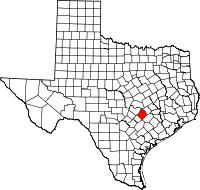 | |
| CDPs | ||
| Other unincorporated communities | ||
| Ghost towns |
| |
| Footnotes | ‡This populated place also has portions in an adjacent county or counties | |