Ridgeway, Virginia
Ridgeway is a town in Henry County, Virginia, United States. The population was 742 at the 2010 census.[5] It is part of the Martinsville Micropolitan Statistical Area. Martinsville Speedway, a NASCAR racetrack, is located between Ridgeway and the Martinsville city limits.
Ridgeway, Virginia | |
|---|---|
 Location of Ridgeway, Virginia | |
| Coordinates: 36°34′45″N 79°51′36″W | |
| Country | United States |
| State | Virginia |
| County | Henry |
| Area | |
| • Total | 0.95 sq mi (2.47 km2) |
| • Land | 0.95 sq mi (2.47 km2) |
| • Water | 0.00 sq mi (0.00 km2) |
| Elevation | 948 ft (289 m) |
| Population (2010) | |
| • Total | 742 |
| • Estimate (2018)[2] | 700 |
| • Density | 732.98/sq mi (283.04/km2) |
| Time zone | UTC−5 (Eastern (EST)) |
| • Summer (DST) | UTC−4 (EDT) |
| ZIP code | 24148 |
| Area code(s) | 276 |
| FIPS code | 51-67208[3] |
| GNIS feature ID | 1473206[4] |
History
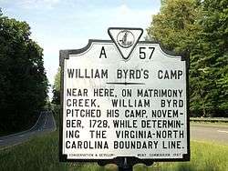
Approximately three miles south of Ridgeway in Henry County on U.S. Route 220 is a Virginia State historic marker noting the passing of the surveying party of William Byrd II, who moved through the area in 1728 on his expedition to survey the dividing line between Virginia and North Carolina.
Belleview and Ingleside are listed on the National Register of Historic Places.[6]
Geography
Ridgeway is located in southern Henry County at 36°34′45″N 79°51′36″W (36.579148, −79.860078).[7] U.S. Route 220 passes through the west side of the town, leading north 8 miles (13 km) to Martinsville and 59 miles (95 km) to Roanoke; and south 40 miles (64 km) to Greensboro, North Carolina. Virginia State Route 87 passes through the center of Ridgeway and leads southeast 8 miles (13 km) to Eden, North Carolina.
According to the United States Census Bureau, Ridgeway has a total area of 0.97 square miles (2.5 km2), all of it land.[5] The north side of Ridgeway drains via Marrowbone Creek and Reds Creek to the Smith River, a tributary of the Dan River, while the south side of town drains to Matrimony Creek, also a tributary of the Dan River.
Demographics
| Historical population | |||
|---|---|---|---|
| Census | Pop. | %± | |
| 1890 | 236 | — | |
| 1900 | 332 | 40.7% | |
| 1910 | 393 | 18.4% | |
| 1920 | 320 | −18.6% | |
| 1930 | 359 | 12.2% | |
| 1940 | 422 | 17.5% | |
| 1950 | 440 | 4.3% | |
| 1960 | 524 | 19.1% | |
| 1970 | 624 | 19.1% | |
| 1980 | 858 | 37.5% | |
| 1990 | 752 | −12.4% | |
| 2000 | 775 | 3.1% | |
| 2010 | 742 | −4.3% | |
| Est. 2018 | 700 | [2] | −5.7% |
| U.S. Decennial Census[8] | |||
At the 2000 census there were 775 people, 310 households, and 221 families living in the town. The population density was 825.3 people per square mile (318.3/km²). There were 327 housing units at an average density of 348.2 per square mile (134.3/km²). The racial makeup of the town was 79.87% White, 16.00% African American, 2.45% Asian, 1.03% from other races, and 0.65% from two or more races. Hispanic or Latino of any race were 2.32%.[3]
Of the 310 households 31.3% had children under the age of 18 living with them, 54.2% were married couples living together, 13.2% had a female householder with no husband present, and 28.4% were non-families. 26.1% of households were one person and 10.6% were one person aged 65 or older. The average household size was 2.50 and the average family size was 3.01.
The age distribution was 25.4% under the age of 18, 6.1% from 18 to 24, 27.7% from 25 to 44, 28.4% from 45 to 64, and 12.4% 65 or older. The median age was 39 years. For every 100 females, there were 86.3 males. For every 100 females age 18 and over, there were 80.6 males.
The median household income was $34,196 and the median family income was $39,500. Males had a median income of $27,109 versus $21,146 for females. The per capita income for the town was $16,054. About 12.1% of families and 12.0% of the population were below the poverty line, including 12.0% of those under age 18 and 15.3% of those age 65 or over.
Notable people
- Jimmy Hensley, NASCAR driver
- Roscoe Reynolds, Virginia state senator
References
- "2018 U.S. Gazetteer Files". United States Census Bureau. Retrieved Feb 16, 2020.
- "Population and Housing Unit Estimates". Retrieved June 4, 2019.
- "U.S. Census website". United States Census Bureau. Retrieved 2008-01-31.
- "US Board on Geographic Names". United States Geological Survey. 2007-10-25. Retrieved 2008-01-31.
- "Geographic Identifiers: 2010 Census Summary File 1 (G001): Ridgeway town, Virginia". American Factfinder. U.S. Census Bureau. Archived from the original on February 13, 2020. Retrieved March 22, 2018.
- "National Register Information System". National Register of Historic Places. National Park Service. July 9, 2010.
- "US Gazetteer files: 2010, 2000, and 1990". United States Census Bureau. 2011-02-12. Retrieved 2011-04-23.
- "Census of Population and Housing". Census.gov. Retrieved June 4, 2015.
Municipalities and communities of Henry County, Virginia, United States | ||
|---|---|---|
| Town | 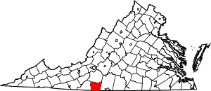 Map of Virginia highlighting Henry County | |
| CDPs | ||
| Unincorporated communities | ||
