King and Queen County, Virginia
King and Queen County is a county in the U.S. state of Virginia, located in the state's Middle Peninsula on the eastern edge of the Richmond, VA metropolitan area. As of the 2010 census, the population was 6,945.[2] Its county seat is King and Queen Court House.[3]
King and Queen County | |
|---|---|
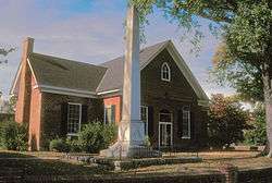 Old King and Queen County Courthouse | |
 Seal | |
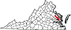 Location within the U.S. state of Virginia | |
 Virginia's location within the U.S. | |
| Coordinates: 37°43′N 76°54′W | |
| Country | |
| State | |
| Founded | 1691 |
| Named for | William III and Mary II of England |
| Seat | King and Queen Court House |
| Area | |
| • Total | 326 sq mi (840 km2) |
| • Land | 315 sq mi (820 km2) |
| • Water | 11 sq mi (30 km2) 3.4% |
| Population (2010) | |
| • Total | 6,945 |
| • Estimate (2018)[1] | 7,042 |
| • Density | 21/sq mi (8.2/km2) |
| Time zone | UTC−5 (Eastern) |
| • Summer (DST) | UTC−4 (EDT) |
| Congressional district | 1st |
| Website | www |
History
King and Queen County was established in 1691 from New Kent County. The county is named for King William III and Queen Mary II of England.[4] King and Queen County is notable as one of the few counties in the United States to have recorded a larger population in the 1790 census than in the 2010 one.
Among the earliest settlers of King and Queen County was Roger Shackelford, an English emigrant from Old Alresford, Hampshire, after whom the county's village of Shacklefords is named. Shackelford's descendants continued to live in the county, and by the nineteenth century had intermarried with several local families, including Taliaferro, Beverley, Thornton, and Sears.[5]
In 1762 when he was 11, future president James Madison was sent to a boarding school run by Donald Robertson at the Innes plantation in King and Queen County. Robertson was a Scottish teacher who tutored numerous prominent plantation families in the South. From Robertson, Madison learned mathematics, geography, and modern and classical languages—he became especially proficient in Latin. He attributed his instinct for learning "largely to that man (Robertson)."[6][7] At age 16, Madison returned to his father's Montpelier estate in Orange County.
On March 2, 1864, the Battle of Walkerton, an engagement of the American Civil War took place here, resulting in a Confederate victory.
Virginia Longest, national director of Nursing Service for the U.S. Department of Veterans Affairs, was a county native.
Richard and Mildred Loving lived in a remote part of the county, hoping to avoid arrest by the authorities while their legal challenge to Virginia's anti-miscegenation laws moved through the courts.
For many years, county publications noted that the county lacked any traffic lights. This is now no longer the case, as a traffic light has been installed on U.S. Route 360 at St. Stephen's Church.
Even in the 21st century, King and Queen County contains no incorporated towns or cities, and remains one of Virginia's most sparsely-populated counties.
Geography
According to the U.S. Census Bureau, the county has a total area of 326 square miles (840 km2), of which 315 square miles (820 km2) is land and 11 square miles (28 km2) (3.4%) is water.[8]
Adjacent Counties
- Caroline County – north
- Essex County – northeast
- Middlesex County – east
- Gloucester County – southeast
- James City County – south
- New Kent County – southwest
- King William County – west
Demographics
| Historical population | |||
|---|---|---|---|
| Census | Pop. | %± | |
| 1790 | 9,377 | — | |
| 1800 | 9,879 | 5.4% | |
| 1810 | 10,988 | 11.2% | |
| 1820 | 11,798 | 7.4% | |
| 1830 | 11,644 | −1.3% | |
| 1840 | 10,862 | −6.7% | |
| 1850 | 10,319 | −5.0% | |
| 1860 | 10,328 | 0.1% | |
| 1870 | 9,709 | −6.0% | |
| 1880 | 10,502 | 8.2% | |
| 1890 | 9,669 | −7.9% | |
| 1900 | 9,265 | −4.2% | |
| 1910 | 9,576 | 3.4% | |
| 1920 | 9,161 | −4.3% | |
| 1930 | 7,618 | −16.8% | |
| 1940 | 6,954 | −8.7% | |
| 1950 | 6,299 | −9.4% | |
| 1960 | 5,889 | −6.5% | |
| 1970 | 5,491 | −6.8% | |
| 1980 | 5,968 | 8.7% | |
| 1990 | 6,289 | 5.4% | |
| 2000 | 6,630 | 5.4% | |
| 2010 | 6,945 | 4.8% | |
| Est. 2018 | 7,042 | [1] | 1.4% |
| U.S. Decennial Census[9] 1790–1960[10] 1900–1990[11] 1990–2000[12] 2010–2013[2] | |||
As of the census[13] of 2000, there were 6,630 people, 2,673 households, and 1,897 families residing in the county. The population density was 21 people per square mile (8/km²). There were 3,010 housing units at an average density of 10 per square mile (4/km²). The racial makeup of the county was 61.22% White, 35.67% Black or African American, 1.42% Native American, 0.27% Asian, 0.02% Pacific Islander, 0.15% from other races, and 1.25% from two or more races. 0.87% of the population were Hispanic or Latino of any race.
There were 2,673 households out of which 26.80% had children under the age of 18 living with them, 52.60% were married couples living together, 13.50% had a female householder with no husband present, and 29.00% were non-families. 24.60% of all households were made up of individuals and 11.00% had someone living alone who was 65 years of age or older. The average household size was 2.48 and the average family size was 2.94.
In the county, the population was spread out with 22.70% under the age of 18, 7.00% from 18 to 24, 26.80% from 25 to 44, 27.00% from 45 to 64, and 16.40% who were 65 years of age or older. The median age was 41 years. For every 100 females there were 95.20 males. For every 100 females age 18 and over, there were 92.50 males.
The median income for a household in the county was $35,941, and the median income for a family was $40,563. Males had a median income of $33,217 versus $21,753 for females. The per capita income for the county was $17,236. 10.90% of the population and 7.80% of families were below the poverty line. Out of the total people living in poverty, 8.10% are under the age of 18 and 14.80% are 65 or older.
Government
Board of Supervisors
- Buena Vista District: James M. Burns
- Newtown District: Sherrin C. Alsop (I)
- Shanghai District: R.F. "Rusty" Bailey, Jr. (I)
- St. Stephens Church District: James Lawrence Simpkins (I)
- Stevensville District: Doris H. Morris (I)
Constitutional officers
- Clerk of the Circuit Court: Vanessa D. Porter
- Commissioner of the Revenue: Kelly N. Lumpkin(I)
- Commonwealth's Attorney: Charles E. Adkins (I)
- Sheriff: John R. Charboneau
- Treasurer: Irene B. Longest
King and Queen is represented by Republican Thomas K. "Tommy" Norment in the Virginia Senate, Republican M. Keith Hodges in the Virginia House of Delegates, and Republican Robert J. "Rob" Wittman in the U.S. House of Representatives.
| Year | Republican | Democratic | Third parties |
|---|---|---|---|
| 2016 | 56.9% 2,099 | 39.8% 1,468 | 3.3% 123 |
| 2012 | 51.0% 1,865 | 47.7% 1,745 | 1.2% 45 |
| 2008 | 47.6% 1,763 | 51.8% 1,918 | 0.7% 24 |
| 2004 | 52.9% 1,737 | 45.8% 1,506 | 1.3% 43 |
| 2000 | 49.8% 1,423 | 48.5% 1,387 | 1.7% 49 |
| 1996 | 38.9% 1,073 | 50.5% 1,393 | 10.5% 290 |
| 1992 | 41.3% 1,206 | 46.7% 1,363 | 11.9% 348 |
| 1988 | 50.5% 1,376 | 48.0% 1,309 | 1.5% 42 |
| 1984 | 54.4% 1,449 | 45.1% 1,201 | 0.5% 14 |
| 1980 | 44.1% 949 | 52.5% 1,128 | 3.4% 73 |
| 1976 | 39.1% 778 | 55.8% 1,111 | 5.2% 103 |
| 1972 | 58.3% 1,033 | 40.0% 708 | 1.8% 31 |
| 1968 | 27.4% 568 | 42.6% 882 | 30.1% 623 |
| 1964 | 46.9% 699 | 52.8% 786 | 0.3% 4 |
| 1960 | 44.0% 432 | 54.5% 536 | 1.5% 15 |
| 1956 | 54.6% 495 | 31.9% 289 | 13.5% 122 |
| 1952 | 51.2% 415 | 47.8% 387 | 1.0% 8 |
| 1948 | 31.3% 171 | 53.6% 293 | 15.2% 83 |
| 1944 | 31.4% 166 | 68.6% 363 | |
| 1940 | 25.3% 124 | 74.5% 365 | 0.2% 1 |
| 1936 | 25.0% 124 | 74.9% 372 | 0.2% 1 |
| 1932 | 28.8% 154 | 68.8% 368 | 2.4% 13 |
| 1928 | 53.3% 319 | 46.7% 280 | |
| 1924 | 29.7% 134 | 69.5% 314 | 0.9% 4 |
| 1920 | 34.3% 181 | 65.7% 347 | |
| 1916 | 31.9% 127 | 68.1% 271 | |
| 1912 | 18.8% 68 | 68.0% 246 | 13.3% 48 |
Communities
- King and Queen Court House (a census-designated place)
- Newtown
- St. Stephen's Church
- Shacklefords
References
- "Population and Housing Unit Estimates". Retrieved July 14, 2019.
- "State & County QuickFacts". United States Census Bureau. Archived from the original on June 7, 2011. Retrieved January 3, 2014.
- "Find a County". National Association of Counties. Archived from the original on 2011-05-31. Retrieved 2011-06-07.
- Gannett, Henry (1905). The Origin of Certain Place Names in the United States. Govt. Print. Off. pp. 175.
- Bagby, Alfred (10 April 2018). "King and Queen County, Virginia". Neale Publishing Company. Retrieved 10 April 2018 – via Google Books.
- Boyd-Rush, Dorothy. "Molding a founding father". James Madison University. Retrieved March 25, 2013.
- "James Madison's Biography". The Montpelier Foundation. Retrieved March 25, 2013.
- "US Gazetteer files: 2010, 2000, and 1990". United States Census Bureau. 2011-02-12. Retrieved 2011-04-23.
- "U.S. Decennial Census". United States Census Bureau. Retrieved January 3, 2014.
- "Historical Census Browser". University of Virginia Library. Retrieved January 3, 2014.
- "Population of Counties by Decennial Census: 1900 to 1990". United States Census Bureau. Retrieved January 3, 2014.
- "Census 2000 PHC-T-4. Ranking Tables for Counties: 1990 and 2000" (PDF). United States Census Bureau. Retrieved January 3, 2014.
- "U.S. Census website". United States Census Bureau. Retrieved 2011-05-14.
- Leip, David. "Dave Leip's Atlas of U.S. Presidential Elections". uselectionatlas.org. Retrieved 10 April 2018.
Places adjacent to King and Queen County, Virginia | ||||||||||
|---|---|---|---|---|---|---|---|---|---|---|
| ||||||||||
Municipalities and communities of King and Queen County, Virginia, United States | ||
|---|---|---|
| CDP | Map of Virginia highlighting King and Queen County | |
| Unincorporated communities |
| |
| Footnotes | ‡This populated place also has portions in an adjacent county or counties | |

| Authority control |
|
|---|