Lee County, Virginia
Lee County is the westernmost county in the U.S. Commonwealth of Virginia. As of the 2018 census estimate, the population was 23,541.[1] Its county seat is Jonesville.[2]
Lee County | |
|---|---|
| Lee County | |
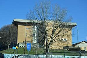 Lee County Courthouse in Jonesville | |
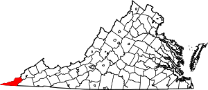 Location within the U.S. state of Virginia | |
 Virginia's location within the U.S. | |
| Coordinates: 36°43′N 83°08′W | |
| Country | |
| State | |
| Founded | October 25, 1792 |
| Named for | Light Horse Harry Lee |
| Seat | Jonesville |
| Largest town | Pennington Gap |
| Area | |
| • Total | 437 sq mi (1,130 km2) |
| • Land | 436 sq mi (1,130 km2) |
| • Water | 1.9 sq mi (5 km2) 0.4% |
| Population (2010) | |
| • Total | 25,587 |
| • Estimate (2018)[1] | 23,541 |
| • Density | 59/sq mi (23/km2) |
| Time zone | UTC−5 (Eastern) |
| • Summer (DST) | UTC−4 (EDT) |
| Congressional district | 9th |
| Website | www |
History
The first Europeans to enter what is present-day Lee County were a party of Spanish explorers, Juan de Villalobos and Francisco de Silvera, sent by Hernando de Soto in 1540, in search of gold.[3]
The county was formed in 1793 from Russell County. It was named for Light Horse Harry Lee,[4] the Governor of Virginia from 1791 to 1794, who was famous for his exploits as a leader of light cavalry during the American Revolutionary War. He was also the father of the Confederate General Robert E. Lee.
Lee County was the final front on the Kentucky Trace, now known as the Wilderness Road and The Trail of the Lonesome Pine. During the 1780s and 1790s, fortified buildings called "stations" were built along the trail for shelter from Indian raids as the settlers followed Daniel Boone's footsteps into Kentucky. The stations in Lee County were Yoakum Station at present-day Dryden, west to Powell River and Station Creek at today's Rocky Station, then to Mump's Fort at Jonesville, followed by Prist Station, Chadwell Station at Chadwell Gap, Martin's Station at Rose Hill, Owen Station at Ewing, and finally Gibson Station, which still bears its original name.
One of the largest early landowners was Revolutionary War officer and explorer Joseph Martin, after whom Martin's Station and Martin's Creek at Rose Hill are named. Due to his rank of command, Martin had been awarded some 25,000 acres (100 km2), which he later divided up and sold. Rose Hill, in 1832, was the first federally recognized post office in the county of Lee.
In 1814, parts of Lee County, Russell County, and Washington County were combined to form Scott County. In 1856, parts of Lee County, Russell County, and Scott County were combined to form Wise County.
Economy
The economy of Lee County has been based largely on growing tobacco and mining coal. The decline of both has resulted in high unemployment in the county and a decrease in population since 1940, which was the peak.
Using the slogan Where Virginia Begins, the county has attempted to increase its heritage tourism industry by emphasizing its role in the route used by settlers going west through the Cumberland Gap, at Lee County's western tip.
Lee County shares Cumberland Gap National Historical Park with Kentucky and Tennessee. Attractions listed in the park include Hensley's Settlement, the Pinnacle Overlook, the Sand Cave, and the White Rocks overlooking the towns of Ewing and Rose Hill in Virginia.
Geography


According to the U.S. Census Bureau, the county has a total area of 437 square miles (1,130 km2), of which 436 square miles (1,130 km2) is land and 1.9 square miles (4.9 km2) (0.4%) is water.[5]
Lee County is physically closer to eight state capitals other than its own capital in Richmond: Raleigh, North Carolina; Columbia, South Carolina; Atlanta, Georgia; Nashville, Tennessee; Charleston, West Virginia; Frankfort, Kentucky; Columbus, Ohio, and Indianapolis, Indiana. Additionally, Cumberland Gap in the far western part of Lee County is closer to Montgomery, Alabama, a ninth state capital.
Districts
The county is divided into seven districts: Jonesville, Rocky Station, Rocky Station Mineral, Rose Hill, White Shoals, Yoakum, St. Charles, Pennington Gap, Keokee, Robbins Chapel and Yoakum Mineral.
Adjacent counties
- Harlan County, Kentucky – north
- Wise County, Virginia – northeast
- Scott County, Virginia – east
- Hancock County, Tennessee – south
- Claiborne County, Tennessee – south-southwest
- Bell County, Kentucky – west
National protected areas
- Cumberland Gap National Historical Park (part)
- Jefferson National Forest (part)
Demographics
| Historical population | |||
|---|---|---|---|
| Census | Pop. | %± | |
| 1800 | 3,538 | — | |
| 1810 | 4,694 | 32.7% | |
| 1820 | 4,256 | −9.3% | |
| 1830 | 6,461 | 51.8% | |
| 1840 | 8,441 | 30.6% | |
| 1850 | 10,267 | 21.6% | |
| 1860 | 11,032 | 7.5% | |
| 1870 | 13,268 | 20.3% | |
| 1880 | 15,116 | 13.9% | |
| 1890 | 18,216 | 20.5% | |
| 1900 | 19,856 | 9.0% | |
| 1910 | 23,840 | 20.1% | |
| 1920 | 25,293 | 6.1% | |
| 1930 | 30,419 | 20.3% | |
| 1940 | 39,296 | 29.2% | |
| 1950 | 36,106 | −8.1% | |
| 1960 | 25,824 | −28.5% | |
| 1970 | 20,321 | −21.3% | |
| 1980 | 25,956 | 27.7% | |
| 1990 | 24,496 | −5.6% | |
| 2000 | 23,589 | −3.7% | |
| 2010 | 25,587 | 8.5% | |
| Est. 2018 | 23,541 | [1] | −8.0% |
| U.S. Decennial Census[6] 1790–1960[7] 1900–1990[8] 1990–2000[9] 2010–2018[1] | |||
As of the 2010 United States Census, there were 25,587 people living in the county. 94.2% were White, 3.7% Black or African American, 0.4% Native American, 0.2% Asian, 0.6% of some other race and 0.9% of two or more races. 1.6% were Hispanic or Latino (of any race).
According to the census[10] 2009 estimates, there were 25001 people, 11,587 households, and 6,852 families living in the county. The population density was 54 people per square mile (21/km²). There were 11,587 housing units at an average density of 25 per square mile (10/km²). The racial makeup of the county was 96.3% White, 2.9% Black or African American, 0.2% Asian, 0.1% from other races, 0.7% of the population were Hispanic or Latino of any race.
The largest ancestry groups in Lee County include: English (14 percent), Irish (11 percent), German (9 percent), and Scottish-Irish (3 percent).[11]
There were 9,706 households out of which 29.0 percent had children under the age of 18 living with them, 55.0 percent were married couples living together, 11.7 percent had a female householder with no husband present, and 29.4 percent were non-families. 27.0 percent of all households were made up of individuals and 12.1 percent had someone living alone who was 65 years of age or older. The average household size was 2.41 and the average family size was 2.91.
In the county, the population was spread out with 22.8 percent under the age of 18, 8.0 percent from 18 to 24, 27.5 percent from 25 to 44, 26.3 percent from 45 to 64, and 15.4 percent who were 65 years of age or older. The median age was 40 years. For every 100 females there were 94.2 males. For every 100 females age 18 and over, there were 91.3 males.
The median income for a household in the county was $29,889, and the median income for a family was $40,721. The per capita income for the county was $16,317. About 20.3 percent of families and 22.7 percent of the population were below the poverty line, including 30.1 percent of those under age 18 and 23.3 percent of those age 65 or over.[12]
Politics
The white majority of Lee County wavered between Democratic and Republican presidential candidates throughout much of the twentieth century. Since the late twentieth century, the county has become more consistently Republican, voting overwhelmingly for Donald Trump in 2016.
| Year | Republican | Democratic | Third parties |
|---|---|---|---|
| 2016 | 80.3% 7,543 | 17.3% 1,627 | 2.4% 229 |
| 2012 | 71.3% 6,847 | 26.9% 2,583 | 1.8% 168 |
| 2008 | 63.1% 5,825 | 34.9% 3,219 | 2.0% 183 |
| 2004 | 58.0% 5,664 | 41.0% 4,005 | 1.0% 101 |
| 2000 | 52.0% 4,551 | 46.1% 4,031 | 1.9% 166 |
| 1996 | 37.5% 3,225 | 51.7% 4,444 | 10.9% 935 |
| 1992 | 35.8% 3,504 | 53.2% 5,215 | 11.0% 1,077 |
| 1988 | 45.1% 4,080 | 54.2% 4,906 | 0.7% 59 |
| 1984 | 50.8% 5,365 | 48.2% 5,085 | 1.0% 104 |
| 1980 | 47.1% 4,417 | 50.7% 4,758 | 2.2% 202 |
| 1976 | 45.5% 4,679 | 52.7% 5,415 | 1.9% 190 |
| 1972 | 62.4% 4,957 | 35.6% 2,825 | 2.1% 163 |
| 1968 | 47.4% 4,450 | 43.7% 4,105 | 9.0% 844 |
| 1964 | 40.2% 3,463 | 59.7% 5,151 | 0.1% 12 |
| 1960 | 46.3% 3,363 | 53.2% 3,867 | 0.5% 35 |
| 1956 | 54.8% 4,548 | 44.7% 3,714 | 0.5% 42 |
| 1952 | 52.0% 4,622 | 47.7% 4,242 | 0.3% 27 |
| 1948 | 50.8% 4,297 | 48.1% 4,069 | 1.2% 100 |
| 1944 | 46.7% 3,921 | 53.2% 4,470 | 0.1% 8 |
| 1940 | 38.5% 2,623 | 61.4% 4,180 | 0.1% 6 |
| 1936 | 33.3% 2,066 | 66.5% 4,120 | 0.2% 13 |
| 1932 | 40.4% 1,985 | 58.8% 2,892 | 0.8% 38 |
| 1928 | 58.3% 3,337 | 41.7% 2,383 | |
| 1924 | 49.7% 2,456 | 48.0% 2,376 | 2.3% 114 |
| 1920 | 57.5% 2,162 | 42.3% 1,592 | 0.2% 7 |
| 1916 | 54.7% 1,569 | 44.9% 1,287 | 0.5% 13 |
| 1912 | 30.2% 699 | 44.1% 1,023 | 25.7% 596 |
Education
Public high schools
- Lee High School, Jonesville
- Thomas Walker High School, Ewing
Public middle schools
- Pennington Middle School, Pennington Gap
- Jonesville Middle School, Jonesville
Public elementary schools
- Dryden Elementary School, Dryden
- Elk Knob Elementary School, Woodway
- Elydale Elementary School, Elydale
- Flatwoods Elementary School, Flatwoods
- Rose Hill Elementary School, Rose Hill
- St. Charles Elementary School, St. Charles
Pennington Elementary School, consisting of three buildings built at various times (1912, 1917 and 1937), was demolished in 1989. A bank was constructed on its Morgan Avenue site. Three other elementary schools, Ewing, Keokee and Stickleyville, were closed in June 2012.[14]
Technical schools
- Lee County Vo/Career Tech, Ben Hur
Communities
Other unincorporated communities
Notable residents
- Pete DeBusk, founder of DeRoyal Industries
- Frank Rowlett, cryptologist, member of the Signals Intelligence Service[15]
- Campbell Slemp, congressman
- Andrew Taylor Still, founder of osteopathic medicine
- William C. Wampler, U.S. Representative
- Barry Audia, professional boxer
- Jim Pankovits, Major League Baseball player
- Elbert S. Martin, congressman
- John Preston Martin, U.S. Senator from Kentucky
- Steve Rasnic Tem, author
- Glen Morgan Williams, federal judge
- Don Newton, comic artist
- James Buchanan Richmond, congressman
- C. Bascom Slemp, congressman
- Carol Wood, mathematician
- Claude Ely, singer/songwriter
- Walker Cress, Major League Baseball player
- Cynthia D Kinser, Chief Justice of the Supreme Court of Virginia
See also
References
- "County Population Totals and Components of Change: 2010-2018". Retrieved May 25, 2019.
- "Find a County". National Association of Counties. Archived from the original on 2011-05-31. Retrieved 2011-06-07.
- Berrier Jr., Ralph (September 20, 2009). "The slaughter at Saltville". The Roanoke Times. Archived from the original on September 11, 2012. Retrieved October 9, 2011.
- Gannett, Henry (1905). The Origin of Certain Place Names in the United States. U.S. Government Printing Office. p. 184.
- "US Gazetteer files: 2010, 2000, and 1990". United States Census Bureau. 2011-02-12. Retrieved 2011-04-23.
- "U.S. Decennial Census". United States Census Bureau. Retrieved January 3, 2014.
- "Historical Census Browser". University of Virginia Library. Retrieved January 3, 2014.
- "Population of Counties by Decennial Census: 1900 to 1990". United States Census Bureau. Retrieved January 3, 2014.
- "Census 2000 PHC-T-4. Ranking Tables for Counties: 1990 and 2000" (PDF). United States Census Bureau. Retrieved January 3, 2014.
- "U.S. Census website". United States Census Bureau. Retrieved 2011-05-14.
- Lee County, VA – Lee County, Virginia – Ancestry & family history – ePodunk
- Bureau, U.S. Census. "American FactFinder – Community Facts". factfinder.census.gov. Archived from the original on 2020-02-11. Retrieved 2018-08-21.
- Leip, David. "Dave Leip's Atlas of U.S. Presidential Elections". uselectionatlas.org. Retrieved 2018-08-21.
- Lee County Public Schools Archived 2008-03-10 at the Wayback Machine
- "Frank B. Rowlett". www.nsa.gov. Retrieved 2018-08-21.
External links
Places adjacent to Lee County, Virginia | |
|---|---|
Municipalities and communities of Lee County, Virginia, United States | ||
|---|---|---|
| Towns | Map of Virginia highlighting Lee County | |
| CDPs | ||
| Unincorporated communities |
| |
| Ghost town | ||

| Authority control |
|
|---|