Amherst County, Virginia
Amherst County is a county, located in the Piedmont region and near the center of the Commonwealth of Virginia in the United States. The county is part of the Lynchburg, VA Metropolitan Statistical Area, and its county seat is also named Amherst.[1]
Amherst County | |
|---|---|
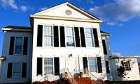 Amherst County Courthouse | |
 Seal | |
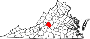 Location within the U.S. state of Virginia | |
 Virginia's location within the U.S. | |
| Coordinates: 37.61°N 79.14°W | |
| Country | |
| State | |
| Founded | 1761 |
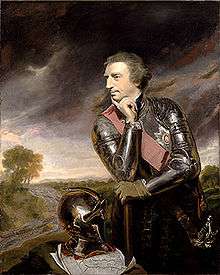
| Named for | Jeffery Amherst |
| Seat | Amherst |
| Largest town | Amherst |
| Area | |
| • Total | 479 sq mi (1,240 km2) |
| • Land | 474 sq mi (1,230 km2) |
| • Water | 4.9 sq mi (13 km2) 1.0% |
| Population (2010) | |
| • Total | 32,353 |
| • Estimate (2018) | 31,666 |
| • Density | 68/sq mi (26/km2) |
| Time zone | UTC−5 (Eastern) |
| • Summer (DST) | UTC−4 (EDT) |
| Congressional district | 6th |
| Website | www |
Amherst County was created in 1761 out of Albemarle County, and it was named in honor of Lord Jeffery Amherst, the so-called "Conqueror of Canada". In 1807 as population increased, the county was reduced in size in order to form Nelson County. Tobacco was the major cash crop of the county during its early years. The labor-intensive crop was worked and processed by enslaved Africans and African Americans before the American Civil War.
As of the 2010 census, the population of the rural county was 32,353, a small increase from the 31,894 people reported in the 2000 census.[2]
History
Beginning thousands of years in the past, Native Americans were the first humans to populate the area. They hunted and fished mainly along the countless rivers and streams in the county. With the establishment of the Virginia Colony in 1607, English emigrants arrived in North America. By the late 17th century English explorers and traders had traveled up the James River to this area. Early trading posts were established between 1710 and 1720. By 1730, many new English colonial families moved into the area currently known as Amherst County, drawn by the desire for land and the good tobacco-growing soil.
Amherst County was formed in 1761, from part of southwestern Albemarle County. The original county seat had been in Cabelsville, now Colleen, in what would later become Nelson County. The county was named for Lord Amherst, known as the "Conqueror of Canada", who commanded the British forces that successfully secured Canada from the French during the Seven Years' War. Jeffery Amherst had previously been named as Governor of Virginia, although he never came to this colony.
In 1806 the county took its present proportions, when Nelson County was formed from its northern half. At that point, the county seat was moved to the village of Five Oaks, later renamed Amherst. The present county courthouse was built in 1870 and has served the county ever since. Amherst County produced more Confederate soldiers per capita than anywhere else in the Confederate States of America.
In the early days, the major crop raised in Amherst County was tobacco. Apple orchards were part of mixed farming that replaced tobacco, especially in the late 19th century. Timber, mining and milling were also important industries. The introduction of the railroad in the late 19th century greatly influenced the county's growth. The county contains many good examples of 18th, 19th and early 20th century rural and small town architecture. The downtown area of Amherst is a classic example of early 20th century commercial architecture.
Recreation and attractions
Recreational attractions are located throughout the county. There are four recreational and public lakes, namely Mill Creek, Thrashers Lake, Otter Lake and Stonehouse Lake, which offer opportunities to fish, canoe or kayak.[3] There are many parks and trails in the county, including about 25 miles of the Appalachian Trail, which runs through the George Washington National Forest.[4] Offshoot trails lead to peaks in Amherst, such at Mount Pleasant, Cole Mountain, and Tar Jacket Ridge.[4]
Festivals in the area
- Rebec Vineyard's Garlic Festival
- Lazy Days Vineyard's Summer Solstice Festival
- Amherst County Sorghum Festival
- The Batteau Festival
Geography
According to the U.S. Census Bureau, the county has a total area of 479 square miles (1,240 km2), of which 474 square miles (1,230 km2) is land and 4.9 square miles (13 km2) (1.0%) is water.[5]
Adjacent counties / Independent city
- Rockbridge County, Virginia – northwest
- Nelson County, Virginia – northeast
- Appomattox County, Virginia – southeast
- Campbell County, Virginia – south
- Lynchburg, Virginia – south (independent city)
- Bedford County, Virginia – southwest
National protected areas
- Blue Ridge Parkway (part)
- George Washington National Forest (part)
Major highways


Demographics
| Historical population | |||
|---|---|---|---|
| Census | Pop. | %± | |
| 1790 | 13,703 | — | |
| 1800 | 16,801 | 22.6% | |
| 1810 | 10,548 | −37.2% | |
| 1820 | 10,423 | −1.2% | |
| 1830 | 12,071 | 15.8% | |
| 1840 | 12,576 | 4.2% | |
| 1850 | 12,699 | 1.0% | |
| 1860 | 13,742 | 8.2% | |
| 1870 | 14,900 | 8.4% | |
| 1880 | 18,709 | 25.6% | |
| 1890 | 17,551 | −6.2% | |
| 1900 | 17,864 | 1.8% | |
| 1910 | 18,932 | 6.0% | |
| 1920 | 19,771 | 4.4% | |
| 1930 | 19,020 | −3.8% | |
| 1940 | 20,273 | 6.6% | |
| 1950 | 20,332 | 0.3% | |
| 1960 | 22,953 | 12.9% | |
| 1970 | 26,072 | 13.6% | |
| 1980 | 29,122 | 11.7% | |
| 1990 | 28,578 | −1.9% | |
| 2000 | 31,894 | 11.6% | |
| 2010 | 32,353 | 1.4% | |
| Est. 2018 | 31,666 | [6] | −2.1% |
| U.S. Decennial Census[7] 1790–1960[8] 1900–1990[9] 1990–2000[10] 2010–2013[2] | |||
As of the census[11] of 2000, there were 31,894 people, 11,941 households, and 8,645 families residing in the county. The population density was 67 people per square mile (26/km²). There were 12,958 housing units at an average density of 27 per square mile (11/km²). The racial makeup of the county was 77.67% White, 19.79% Black or African American, 0.81% Native American, 0.35% Asian, 0.02% Pacific Islander, 0.41% from other races, and 0.94% from two or more races. 0.96% of the population were Hispanic or Latino of any race.
There were 11,941 households out of which 31.70% had children under the age of 18 living with them, 56.00% were married couples living together, 12.40% had a female householder with no husband present, and 27.60% were non-families. 24.00% of all households were made up of individuals and 9.90% had someone living alone who was 65 years of age or older. The average household size was 2.51 and the average family size was 2.95.
In the county, the population was spread out with 23.50% under the age of 18, 9.70% from 18 to 24, 27.70% from 25 to 44, 25.30% from 45 to 64, and 13.80% who were 65 years of age or older. The median age was 38 years. For every 100 females there were 91.10 males. For every 100 females age 18 and over, there were 87.10 males.
The median income for a household in the county was $37,393, and the median income for a family was $42,876. Males had a median income of $31,493 versus $22,155 for females. The per capita income for the county was $16,952. About 8.00% of families and 10.70% of the population were below the poverty line, including 13.20% of those under age 18 and 11.60% of those age 65 or over.
Government
The Board of Supervisors are elected from single-member districts.
Board of Supervisors
- District 1: Ken Campbell (I) Vice Chairman
- District 2: Claudia Tucker (I)
- District 3: Jimmy Ayers (I) Chairman
- District 4: David Pugh, Jr. (R)
- District 5: Jennifer Moore (I)
Constitutional officers
- Clerk of the Circuit Court: Deborah C. Mozingo [12]
- Commissioner of the Revenue: Jane Irby (I)[12]
- Commonwealth's Attorney: W. Lyle Carver[13]
- Sheriff: E.W. Viar Jr.[14] (I)
- Treasurer: Joanne Carden [13]
Amherst County is represented by Republican Tom A. Garrett, Jr. in the Virginia Senate, Republican T. Scott Garrett and Republican Ronnie R. Campbell in the Virginia House of Delegates, and Republican Ben Cline in the U.S. House of Representatives.
| Year | Republican | Democratic | Third parties |
|---|---|---|---|
| 2016 | 63.1% 9,719 | 32.9% 5,057 | 4.0% 620 |
| 2012 | 59.3% 8,876 | 39.4% 5,900 | 1.3% 194 |
| 2008 | 57.6% 8,470 | 41.5% 6,094 | 0.9% 136 |
| 2004 | 61.1% 7,758 | 38.3% 4,866 | 0.6% 71 |
| 2000 | 56.9% 6,660 | 41.1% 4,812 | 2.1% 240 |
| 1996 | 46.6% 5,094 | 44.5% 4,864 | 8.8% 966 |
| 1992 | 50.3% 5,482 | 37.6% 4,101 | 12.1% 1,325 |
| 1988 | 64.1% 6,507 | 35.1% 3,567 | 0.8% 77 |
| 1984 | 66.5% 7,004 | 32.4% 3,409 | 1.1% 117 |
| 1980 | 57.6% 5,088 | 39.3% 3,476 | 3.1% 276 |
| 1976 | 50.9% 3,956 | 47.3% 3,675 | 1.9% 145 |
| 1972 | 73.9% 4,909 | 22.8% 1,512 | 3.3% 218 |
| 1968 | 39.8% 2,656 | 23.1% 1,543 | 37.1% 2,475 |
| 1964 | 49.5% 2,675 | 50.5% 2,730 | 0.1% 5 |
| 1960 | 38.8% 1,455 | 60.9% 2,280 | 0.3% 12 |
| 1956 | 42.6% 1,529 | 53.8% 1,933 | 3.6% 128 |
| 1952 | 40.2% 1,407 | 59.4% 2,078 | 0.4% 15 |
| 1948 | 18.7% 460 | 60.1% 1,481 | 21.3% 525 |
| 1944 | 14.5% 442 | 85.1% 2,585 | 0.4% 12 |
| 1940 | 12.4% 292 | 87.3% 2,048 | 0.3% 7 |
| 1936 | 11.9% 236 | 87.8% 1,734 | 0.3% 6 |
| 1932 | 9.9% 195 | 89.1% 1,764 | 1.1% 21 |
| 1928 | 23.7% 447 | 76.3% 1,442 | |
| 1924 | 9.7% 129 | 82.3% 1,092 | 8.0% 106 |
| 1920 | 13.2% 168 | 86.1% 1,094 | 0.6% 8 |
| 1916 | 7.5% 93 | 91.6% 1,142 | 1.0% 12 |
| 1912 | 7.1% 64 | 85.3% 765 | 7.6% 68 |
Communities
Town
Census-designated place
Notable residents
- James John Floyd (1750-1783), born in Amherst County. co-founder of Louisville, KY and early settler in that area. Kentucky Colonel and pioneer judge. Among several places named for him is Floyd Street in Louisville.
- William Barnett (1761–1834), born in Amherst County, United States Congressman[16]
- William Becknell, born in Amherst County, first white man to open what would become the Santa Fe Trail[16]
- Samuel Jordan Cabell (1756–1818), born in Amherst County, United States Congressman[16]
- Peter Cartwright (1785–1872), born in Amherst County, noted "hellfire and brimstone" preacher[16]
- Powhatan Ellis, (1790–1863), born in Amherst County, justice of the Mississippi Supreme Court, United States Senator from Mississippi, and minister to Mexico. Ellisville, Mississippi, is named in his honor.[16]
- David S. Garland (1769–1841), Congressman, master of the Brick House (Clifford, Virginia), founder of the New Glasgow Academy.
- Ottie Cline Powell (1890–1894), born in Amherst County four-year-old boy who died after getting lost collecting firewood outside his schoolhouse. Reportedly haunts the area he died at.[17][18][19]
References
- "Find a County". National Association of Counties. Archived from the original on 2011-05-31. Retrieved 2011-06-07.
- "State & County QuickFacts". United States Census Bureau. Archived from the original on July 6, 2011. Retrieved December 31, 2013.
- "Lakes". Virginia Department of Game and Inland Fisheries. Retrieved 5 January 2019.
- "Trails". www.countyofamherst.com. Amherst County, Virginia. Retrieved 5 January 2019.
- "US Gazetteer files: 2010, 2000, and 1990". United States Census Bureau. 2011-02-12. Retrieved 2011-04-23.
- "Population and Housing Unit Estimates". Retrieved July 14, 2019.
- "U.S. Decennial Census". United States Census Bureau. Retrieved December 31, 2013.
- "Historical Census Browser". University of Virginia Library. Retrieved December 31, 2013.
- "Population of Counties by Decennial Census: 1900 to 1990". United States Census Bureau. Retrieved December 31, 2013.
- "Census 2000 PHC-T-4. Ranking Tables for Counties: 1990 and 2000" (PDF). United States Census Bureau. Retrieved December 31, 2013.
- "U.S. Census website". United States Census Bureau. Retrieved 2011-05-14.
- https://www.countyofamherst.com/egov/apps/staff/directory.egov
- "Staff Directory / Details / / Amherst County, VA". www.countyofamherst.com. Retrieved 2018-08-17.
- Leip, David. "Dave Leip's Atlas of U.S. Presidential Elections". uselectionatlas.org. Retrieved 2018-08-17.
- Who Was Who in America, Historical Volume, 1607–1896. Chicago: Marquis Who's Who. 1963.
- "10 Great Places To Go On A Haunted Hike". USA Today. July 28, 2006.
- http://www.trails.com/list_12425_haunted-forests-north-america.html
- Perry, Tristan. Ghostly Legends of the Appalachian Trail. Wever, Iowa: Quixote Press, 2008. Pages 93-102.
Places adjacent to Amherst County, Virginia | ||||||||||
|---|---|---|---|---|---|---|---|---|---|---|
| ||||||||||
Municipalities and communities of Amherst County, Virginia, United States | ||
|---|---|---|
| Town | Map of Virginia highlighting Amherst County | |
| CDP | ||
| Unincorporated communities | ||

| Authority control |
|
|---|