Surry, Virginia
Surry (formerly Cross Roads, McIntosh's Cross Roads, McIntoshs Cross Roads, Scuffletown, Smithville, Surry Court House, and The Crossroads)[5] is an incorporated town in Surry County, Virginia, United States. The population was 244 at the 2010 census. It is the county seat of Surry County.[6] Its name is derived from the historic county of Surrey in England.
Surry, Virginia | |
|---|---|
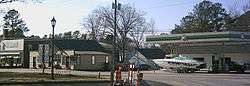 Shops and a gas station in downtown Surry | |
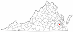 Location of Surry, Virginia | |
| Coordinates: 37°8′9″N 76°50′7″W | |
| Country | United States |
| State | Virginia |
| County | Surry |
| Surry | 1652 |
| Area | |
| • Total | 0.83 sq mi (2.1 km2) |
| • Land | 0.83 sq mi (2.1 km2) |
| • Water | 0.00 sq mi (0.0 km2) |
| Elevation | 121 ft (37 m) |
| Population (2010) | |
| • Total | 244 |
| • Estimate (2018)[2] | 220 |
| • Density | 290/sq mi (110/km2) |
| Time zone | UTC-5 (Eastern (EST)) |
| • Summer (DST) | UTC-4 (EDT) |
| ZIP code | 23883 |
| Area code(s) | 757, 948 (planned) |
| FIPS code | 51-76880[3] |
| GNIS feature ID | 1500197[4] |
| Website | www.surrycountyva.gov |
Geography
According to the United States Census Bureau, the town has a total area of 0.8 square miles (2.1 km²), all of it land.
Demographics
| Historical population | |||
|---|---|---|---|
| Census | Pop. | %± | |
| 1930 | 243 | — | |
| 1940 | 254 | 4.5% | |
| 1950 | 248 | −2.4% | |
| 1960 | 288 | 16.1% | |
| 1970 | 269 | −6.6% | |
| 1980 | 237 | −11.9% | |
| 1990 | 192 | −19.0% | |
| 2000 | 262 | 36.5% | |
| 2010 | 244 | −6.9% | |
| Est. 2018 | 220 | [2] | −9.8% |
| U.S. Decennial Census[7] | |||
At the 2000 census there were 262 people, 109 households, and 80 families living in the town. The population density was 323.7 people per square mile (124.9/km²). There were 119 housing units at an average density of 147.0 per square mile (56.7/km²). The racial makeup of the town was 74.05% White, 23.28% African American, 1.15% Native American, 1.53% from other races. Hispanic or Latino of any race were 0.76%.[3]
Of the 109 households 30.3% had children under the age of 18 living with them, 53.2% were married couples living together, 11.9% had a female householder with no husband present, and 26.6% were non-families. 24.8% of households were one person and 8.3% were one person aged 65 or older. The average household size was 2.40 and the average family size was 2.83.
The age distribution was 21.8% under the age of 18, 8.4% from 18 to 24, 33.2% from 25 to 44, 21.4% from 45 to 64, and 15.3% 65 or older. The median age was 39 years. For every 100 females there were 98.5 males. For every 100 females age 18 and over, there were 97.1 males.
The median household income was $42,361 and the median family income was $51,071. Males had a median income of $30,000 versus $22,500 for females. The per capita income for the town was $21,606. About 10.8% of families and 10.7% of the population were below the poverty line, including 13.3% of those under the age of eighteen and 5.0% of those sixty five or over.
References
- "2018 U.S. Gazetteer Files". United States Census Bureau. Retrieved Feb 16, 2020.
- "Population and Housing Unit Estimates". Retrieved June 4, 2019.
- "U.S. Census website". United States Census Bureau. Retrieved 2008-01-31.
- "US Board on Geographic Names". United States Geological Survey. 2007-10-25. Retrieved 2008-01-31.
- U.S. Geological Survey Geographic Names Information System: Surry, Virginia
- "Find a County". National Association of Counties. Retrieved 2011-06-07.
- "Census of Population and Housing". Census.gov. Retrieved June 4, 2015.
Municipalities and communities of Surry County, Virginia, United States | ||
|---|---|---|
| Towns | 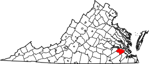 Map of Virginia highlighting Surry County | |
| CDP | ||
| Unincorporated communities | ||
| Authority control |
|
|---|