Amelia County, Virginia
Amelia County is a United States county located just west of Richmond in the Commonwealth of Virginia. The county is included in the Greater Richmond Region, and its county seat is Amelia Courthouse.[1]
Amelia County | |
|---|---|
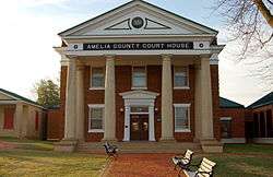 Amelia County Court House | |
 Seal | |
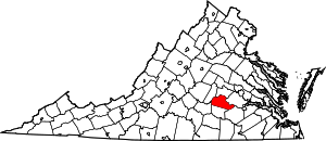 Location within the U.S. state of Virginia | |
 Virginia's location within the U.S. | |
| Coordinates: 37°20′N 77°59′W | |
| Country | |
| State | |
| Founded | 1735 |
| Named for | Princess Amelia |
| Seat | Amelia Court House |
| Area | |
| • Total | 359 sq mi (930 km2) |
| • Land | 355 sq mi (920 km2) |
| • Water | 3.3 sq mi (9 km2) 0.9% |
| Population (2010) | |
| • Total | 12,690 |
| • Estimate (2018) | 13,013 |
| • Density | 35/sq mi (14/km2) |
| Time zone | UTC−5 (Eastern) |
| • Summer (DST) | UTC−4 (EDT) |
| Congressional district | 7th |
| Website | www |
Amelia County was created in 1735 from parts of Prince George and Brunswick counties, and it was named in honor of Princess Amelia of Great Britain. Parts of the county were later carved out to create Prince Edward and Nottoway counties.
As of the 2010 census, the county population was 12,690, which is an increase of more than 44 percent from the 1990 census.[2]
History
_by_Jean-Baptiste_van_Loo.jpg)
Amelia County was created by a legislative act in 1734 and 1735[3] from parts of Prince George and Brunswick counties. The County is named for Princess Amelia of Great Britain, daughter of King George II. As was customary, as population increased in the region, Amelia County was reduced by the division of territory to form newer counties; in 1754, Prince Edward County was formed from parts of Amelia County, and in 1789, Nottoway County was formed. It was developed for plantation agriculture dependent on slave labor.
During the Civil War General Robert E. Lee and his Army spent April 4 and 5, 1865 at Amelia Courthouse before his surrender on April 9 to General Ulysses S. Grant at Appomattox. The last major battle of his army was fought at Sayler's Creek on April 6.
Amelia is known for its minerals, including the nation's best supply of amazonite, a green feldspar found at the Morefield mine. In the 19th century, spas were developed around its mineral springs, which were destinations for travelers.
In 1986 the Amelia County Fair sponsored a competition for the world's largest potato pancake (with apple sauce). It was constructed to raise money that year for the German American National Scholarship Fund. The pancake weighed more than two and one quarter tons and used four truck loads of potatoes.
Geography
According to the U.S. Census Bureau, the county has a total area of 359 square miles (930 km2), of which 355 square miles (920 km2) is land and 3.3 square miles (8.5 km2) (0.9%) is water.[4]
Adjacent counties
- Powhatan County - north
- Chesterfield County - east
- Dinwiddie County - southeast
- Nottoway County - south
- Prince Edward County - southwest
- Cumberland County - west
Transportation
These are the highways and main roads that go through Amelia County.


Demographics
| Historical population | |||
|---|---|---|---|
| Census | Pop. | %± | |
| 1790 | 18,097 | — | |
| 1800 | 9,432 | −47.9% | |
| 1810 | 10,594 | 12.3% | |
| 1820 | 11,104 | 4.8% | |
| 1830 | 11,036 | −0.6% | |
| 1840 | 10,320 | −6.5% | |
| 1850 | 9,770 | −5.3% | |
| 1860 | 10,741 | 9.9% | |
| 1870 | 9,878 | −8.0% | |
| 1880 | 10,377 | 5.1% | |
| 1890 | 9,068 | −12.6% | |
| 1900 | 9,037 | −0.3% | |
| 1910 | 8,720 | −3.5% | |
| 1920 | 9,800 | 12.4% | |
| 1930 | 8,799 | −10.2% | |
| 1940 | 8,495 | −3.5% | |
| 1950 | 7,908 | −6.9% | |
| 1960 | 7,815 | −1.2% | |
| 1970 | 7,592 | −2.9% | |
| 1980 | 8,405 | 10.7% | |
| 1990 | 8,787 | 4.5% | |
| 2000 | 11,400 | 29.7% | |
| 2010 | 12,690 | 11.3% | |
| Est. 2018 | 13,013 | [5] | 2.5% |
| U.S. Decennial Census[6] 1790-1960[7] 1900-1990[8] 1990-2000[9] 2010-2013[2] | |||
As of the census[10] of 2000, there were 11,400 people, 4,240 households, and 3,175 families residing in the county. The population density was 32 people per square mile (12/km²). There were 4,609 housing units at an average density of 13 per square mile (5/km²). The racial makeup of the county was 70.57% White, 28.05% Black or African American, 0.28% Native American, 0.17% Asian, 0.02% Pacific Islander, 0.25% from other races, and 0.67% from two or more races. 0.80% of the population were Hispanic or Latino of any race.
There were 4,240 households out of which 32.80% had children under the age of 18 living with them, 59.10% were married couples living together, 11.40% had a female householder with no husband present, and 25.10% were non-families. 20.70% of all households were made up of individuals and 8.10% had someone living alone who was 65 years of age or older. The average household size was 2.66 and the average family size was 3.07.
In the county, the population was spread out with 25.30% under the age of 18, 6.70% from 18 to 24, 29.20% from 25 to 44, 25.40% from 45 to 64, and 13.30% who were 65 years of age or older. The median age was 38 years. For every 100 females there were 97.30 males. For every 100 females age 18 and over, there were 94.20 males.
The median income for a household in the county was $40,252, and the median income for a family was $47,157. Males had a median income of $32,315 versus $23,102 for females. The per capita income for the county was $18,858. 8.40% of the population and 6.70% of families were below the poverty line. Out of the total people living in poverty, 7.10% are under the age of 18 and 11.70% are 65 or older.
Government
Board of Supervisors
- District 1: Thomas Gleason (I)
- District 2: Roger A. Scott (I)
- District 3: Shaun Weyant, vice Chairman (I)
- District 4: H. Joseph Easter, IV (I)
- District 5: Franklin D. Harris, Chairman (D)
Constitutional officers
- Clerk of the Circuit Court: Marilyn L. Wilson (D)
- Commissioner of the Revenue: Laura Walsh (I)
- Commonwealth's Attorney: Lee R. Harrison (I)
- Sheriff: Rick Walker (I)
- Treasurer: Stephanie Coleman (I)
Amelia County is represented by Republican Amanda Chase in the Virginia Senate, Republican Thomas C. Wright, Jr. in the Virginia House of Delegates, and Democrat Abigail Spanberger in the U.S. House of Representatives.
| Year | Republican | Democratic | Third parties |
|---|---|---|---|
| 2016 | 66.9% 4,708 | 30.2% 2,128 | 2.9% 204 |
| 2012 | 62.6% 4,331 | 36.0% 2,490 | 1.4% 94 |
| 2008 | 60.8% 3,970 | 38.1% 2,488 | 1.1% 71 |
| 2004 | 64.8% 3,499 | 34.5% 1,862 | 0.7% 36 |
| 2000 | 61.6% 2,947 | 36.6% 1,754 | 1.8% 87 |
| 1996 | 51.1% 2,119 | 39.2% 1,625 | 9.7% 400 |
| 1992 | 48.8% 2,062 | 36.3% 1,534 | 14.9% 628 |
| 1988 | 60.9% 2,187 | 37.8% 1,359 | 1.3% 48 |
| 1984 | 61.4% 2,336 | 37.6% 1,432 | 1.0% 36 |
| 1980 | 53.2% 1,969 | 44.4% 1,643 | 2.4% 89 |
| 1976 | 47.3% 1,634 | 49.6% 1,715 | 3.2% 109 |
| 1972 | 65.0% 1,606 | 31.5% 778 | 3.5% 87 |
| 1968 | 33.9% 857 | 32.8% 830 | 33.3% 841 |
| 1964 | 60.2% 1,348 | 39.5% 884 | 0.3% 7 |
| 1960 | 51.4% 784 | 46.5% 708 | 2.1% 32 |
| 1956 | 43.1% 745 | 23.3% 403 | 33.6% 580 |
| 1952 | 53.6% 832 | 45.3% 703 | 1.0% 16 |
| 1948 | 35.2% 372 | 41.9% 443 | 23.0% 243 |
| 1944 | 34.7% 295 | 65.0% 553 | 0.4% 3 |
| 1940 | 32.1% 267 | 67.6% 562 | 0.2% 2 |
| 1936 | 24.0% 239 | 75.5% 753 | 0.5% 5 |
| 1932 | 16.6% 142 | 82.1% 701 | 1.3% 11 |
| 1928 | 35.7% 277 | 64.3% 498 | |
| 1924 | 28.3% 153 | 68.9% 372 | 2.8% 15 |
| 1920 | 31.2% 179 | 67.8% 389 | 1.1% 6 |
| 1916 | 16.4% 80 | 82.6% 403 | 1.0% 5 |
| 1912 | 7.8% 32 | 79.5% 325 | 12.7% 52 |
Media
The Amelia Bulletin Monitor, a weekly newspaper, has covered the county since 1973.
Communities
There are no incorporated communities in Amelia County.
Notable residents
- William S. Archer, born in Amelia County, United States Senator from Virginia[12]
- Van T. Barfoot (1919-2012), U.S. Army Colonel and a U.S. Congressional Medal of Honor Recipient
- William Wyatt Bibb, born in Amelia County, United States Senator from Georgia and first Governor of Alabama[12]
- Jesse Bragg, Negro league baseball player
- William Cocke (1747–1828), born in Amelia County, first United States Senator from Tennessee[12]
- Henry William Connor (1793–1866), born near Amelia Court House, elected as United States Congressman from North Carolina[12]
- David Fanning, (1755–1825), born in Amelia County. A Loyalist officer during the American Revolutionary War, he captured Thomas Burke, a court martial judge and Governor of North Carolina. One of only three individuals excluded from the amnesty after the Revolutionary War, Fanning moved to New Brunswick in present-day Canada for resettlement.[12]
- William Branch Giles, (1762–1830), born in Amelia County. Planter, United States Congressman, United States Senator, and Governor of Virginia.[12]
- Edmund Harrison (1764–1826), Speaker of the Virginia House of Delegates (1802–1803).
- John Winston Jones, (1791–1848), born in Amelia County. Speaker of the United States House of Representatives.[12]
- Nellie A. Ramsey Leslie (c.1840s-c.1920s), born into slavery in Amelia County,[13] she became a noted musician, teacher and composer, founding a musical conservatory in Corpus Christi, Texas.
- Robert Russa Moton (1867–1940), noted African-American educator. He was born in Amelia County but was raised in Rice, in nearby Prince Edward County, Virginia
- Mary Virginia Terhune, (1830-1922) born in Amelia County. Prolific and bestselling author in both fiction and non-fiction, the first woman elected to the Virginia Historical Society
References
- "Find a County". National Association of Counties. Archived from the original on 2011-05-31. Retrieved 2011-06-07.
- "State & County QuickFacts". United States Census Bureau. Archived from the original on July 6, 2011. Retrieved December 31, 2013.
- History of Amelia County Archived 2010-12-05 at the Wayback Machine
- "US Gazetteer files: 2010, 2000, and 1990". United States Census Bureau. 2011-02-12. Retrieved 2011-04-23.
- "Population and Housing Unit Estimates". Retrieved July 14, 2019.
- "U.S. Decennial Census". United States Census Bureau. Retrieved December 31, 2013.
- "Historical Census Browser". University of Virginia Library. Retrieved December 31, 2013.
- "Population of Counties by Decennial Census: 1900 to 1990". United States Census Bureau. Retrieved December 31, 2013.
- "Census 2000 PHC-T-4. Ranking Tables for Counties: 1990 and 2000" (PDF). United States Census Bureau. Retrieved December 31, 2013.
- "U.S. Census website". United States Census Bureau. Retrieved 2011-05-14.
- Leip, David. "Dave Leip's Atlas of U.S. Presidential Elections". uselectionatlas.org.
- Who Was Who in America, Historical Volume, 1607-1896. Chicago: Marquis Who's Who. 1963.
- Scruggs, Lawson Andrew (1893). Women of Distinction: Remarkable in Works and Invincible in Character. Raleigh, North Carolina: L. A. Scruggs. p. 247. OCLC 4255360.CS1 maint: ref=harv (link)
External links
- http://www.ameliacova.com - Official Amelia County Website
- https://web.archive.org/web/20191115180811/http://ameliabusinessdirectory.com/ - Amelia Business Directory
- Amelia Co. Christmas 1784
- http://www.ameliamonitor.com - Amelia County's newspaper
Places adjacent to Amelia County, Virginia | ||||||||||
|---|---|---|---|---|---|---|---|---|---|---|
| ||||||||||
Municipalities and communities of Amelia County, Virginia, United States | ||
|---|---|---|
County seat: Amelia Courthouse | ||
| CDP |
| Map of Virginia highlighting Amelia County |
| Unincorporated communities | ||

| Authority control |
|
|---|