Louisa, Virginia
Louisa (originally named Louisa Court House) is a town in Louisa County, Virginia, United States. The population was 1,555 at the 2010 census. It is the county seat of Louisa County.[5]
Louisa, Virginia | |
|---|---|
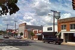 Main Street, Downtown Louisa | |
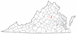 Location in Virginia | |
| Coordinates: 38°1′27″N 78°0′6″W | |
| Country | United States |
| State | Virginia |
| County | Louisa |
| Founded | 1873 |
| Government | |
| • Mayor | R. Garland Nuckols |
| Area | |
| • Total | 1.84 sq mi (4.77 km2) |
| • Land | 1.83 sq mi (4.73 km2) |
| • Water | 0.01 sq mi (0.04 km2) |
| Elevation | 466 ft (142 m) |
| Population (2010) | |
| • Total | 1,555 |
| • Estimate (2018)[2] | 1,702 |
| • Density | 931.58/sq mi (359.73/km2) |
| Time zone | UTC−5 (Eastern (EST)) |
| • Summer (DST) | UTC−4 (EDT) |
| ZIP code | 23093 |
| Area code(s) | 540 |
| FIPS code | 51-47144[3] |
| GNIS feature ID | 1498507[4] |
| Website | http://louisatown.org/ |
History
Bloomington, Boxley Place, the Louisa County Courthouse, and Louisa High School are listed on the National Register of Historic Places.[6]
Geography
Louisa is located at 38°1′27″N 78°0′6″W (38.024057, −78.001584).[7]
According to the United States Census Bureau, the city has a total area of 1.8 square miles (4.7 km²), of which 1.8 square miles (4.7 km²) is land and 0.55% is water.
Demographics
| Historical population | |||
|---|---|---|---|
| Census | Pop. | %± | |
| 1880 | 315 | — | |
| 1900 | 261 | — | |
| 1910 | 318 | 21.8% | |
| 1920 | 289 | −9.1% | |
| 1930 | 301 | 4.2% | |
| 1940 | 365 | 21.3% | |
| 1950 | 344 | −5.8% | |
| 1960 | 576 | 67.4% | |
| 1970 | 633 | 9.9% | |
| 1980 | 932 | 47.2% | |
| 1990 | 1,088 | 16.7% | |
| 2000 | 1,401 | 28.8% | |
| 2010 | 1,555 | 11.0% | |
| Est. 2018 | 1,702 | [2] | 9.5% |
| U.S. Decennial Census[8] | |||
At the 2000 census there were 1,401 people, 584 households, and 331 families in the town. The population density was 766.8 people per square mile (295.6/km²). There were 620 housing units at an average density of 339.4 per square mile (130.8/km²). The racial makeup of the town was 66.81% White, 29.48% African American, 0.79% Native American, 0.71% Asian, 0.79% from other races, and 1.43% from two or more races. Hispanic or Latino of any race were 1.43%.[3]
Of the 584 households 30.0% had children under the age of 18 living with them, 35.6% were married couples living together, 16.4% had a female householder with no husband present, and 43.3% were non-families. 37.0% of households were one person and 18.3% were one person aged 65 or older. The average household size was 2.25 and the average family size was 2.93.
The age distribution was 24.8% under the age of 18, 7.9% from 18 to 24, 28.5% from 25 to 44, 19.2% from 45 to 64, and 19.6% 65 or older. The median age was 38 years. For every 100 females, there were 81.5 males. For every 100 females age 18 and over, there were 73.1 males.
The median household income was $29,519 and the median family income was $42,396. Males had a median income of $27,578 versus $23,188 for females. The per capita income for the town was $17,763. About 14.7% of families and 18.7% of the population were below the poverty line, including 27.9% of those under age 18 and 17.0% of those age 65 or over.
Points of interest

Louisa is home to the North Anna Nuclear Generating Station which produces electricity and offers jobs for the county's inhabitants. The warm water produced from the power plant and discharged into the water of Lake Anna creates what some call Central Virginia's best fishing.
Louisa is also home to the Twin Oaks Community, an intentional community of 100 people living on 465 acres (1.88 km2). The community has been in Louisa since 1967.
The 2011 Virginia earthquake had its epicenter just 7 miles (11 kilometers) south-southeast of Louisa.[9] This quake registered 5.8 magnitude, and caused the evacuations of buildings on Capitol Hill in Washington, D.C., as well as New York City and was felt as far north as Canada.
Public services
Jefferson-Madison Regional Library is the regional library system that provides services to the citizens of Louisa.
Notable person
- Kerry Wynn -Defensive end for Cincinnati Bengals.
- Tucker “Skeeter” Pleasants -Local Mullet Legend
References
- "2018 U.S. Gazetteer Files". United States Census Bureau. Retrieved Feb 16, 2020.
- "Population and Housing Unit Estimates". Retrieved June 4, 2019.
- "U.S. Census website". United States Census Bureau. Retrieved 2008-01-31.
- "US Board on Geographic Names". United States Geological Survey. 2007-10-25. Retrieved 2008-01-31.
- "Find a County". National Association of Counties. Retrieved 2011-06-07.
- "National Register Information System". National Register of Historic Places. National Park Service. July 9, 2010.
- "US Gazetteer files: 2010, 2000, and 1990". United States Census Bureau. 2011-02-12. Retrieved 2011-04-23.
- "Census of Population and Housing". Census.gov. Retrieved June 4, 2015.
- Magnitude 5.8 - VIRGINIA Archived October 6, 2014, at the Wayback Machine
External links
Municipalities and communities of Louisa County, Virginia, United States | ||
|---|---|---|
| Towns | 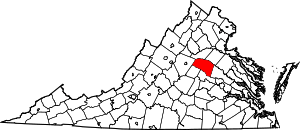 Map of Virginia highlighting Louisa County | |
| CDP | ||
| Unincorporated communities |
| |
| Footnotes | ‡This populated place also has portions in an adjacent county or counties | |
| Authority control |
|
|---|