Buena Vista, Virginia
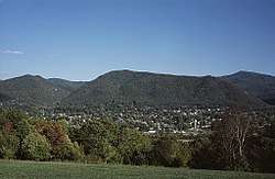
Buena Vista (/ˌbjuːnəˈvɪstə/ BEW-nə-VIS-tə) is an independent city located in the Blue Ridge Mountains region of Virginia in the United States. As of the 2010 census, the population was 6,650.[5] The Bureau of Economic Analysis combines the independent cities of Buena Vista and Lexington, along with surrounding Rockbridge County, for statistical purposes.
Buena Vista, Virginia | |
|---|---|
 | |
 Buena Vista  Buena Vista  Buena Vista | |
| Coordinates: 37°44′04″N 79°21′15″W | |
| Country | United States |
| State | Virginia |
| County | None (Independent city) |
| Area | |
| • Total | 6.52 sq mi (16.89 km2) |
| • Land | 6.44 sq mi (16.67 km2) |
| • Water | 0.09 sq mi (0.22 km2) |
| Elevation | 837 ft (255 m) |
| Population (2010) | |
| • Total | 6,650 |
| • Estimate (2019)[2] | 6,478 |
| • Density | 1,000/sq mi (390/km2) |
| Time zone | UTC−5 (Eastern (EST)) |
| • Summer (DST) | UTC−4 (EDT) |
| Zip code | 24416 |
| FIPS code | 51-11032[3] |
| GNIS feature ID | 1492666[4] |
| Website | www |
History
Formerly named Hart's Bottom, Green Forest or Green Valley[6] until 1888, and chartered as a town in 1890, Buena Vista was granted a city charter on February 15, 1892.
The Buena Vista Downtown Historic District, Buena Vista Colored School, Cedar Hill, Glen Maury, Old Courthouse, Southern Seminary Main Building, and W.N. Seay House are listed on the National Register of Historic Places.[8]
Early history
Founded by Benjamin C. Moomaw in the late 1800s, the town consisted only of a simple tannery at the intersection of two railroads and a canal. The Richmond and Alleghany Railroad and the Shenandoah Valley Railroad,[9] stood alongside the James River Canal that had been used to transport materials from the Atlantic ports of Virginia to Lexington since the 18th century,[10] but by the founding of the city had been converted for the distribution of water power.[9] After opening the tannery, Moomaw opened a pulp mill and a canning factory. In 1882 Appold & Sons Tannery opened, and the first public school opened in 1885.
In 1893, the town was described as "one of the many new towns that seem to have sprung up as if by magic in some parts of Virginia." Previous to 1889 none of the 600 dwellings, churches, stores, hotels and other buildings in the town had been built "but where are streets and all that goes to make a booming city the reapers that year gathered a luxuriant crop of wheat."[9] In December 1888, Moomaw wrote the Buena Vista Prospectus to organize a town and began selling stock. "It took only 30 days for all the stock to be sold for a total of $400,000. With the sale completed, it was time to lay out the town and begin recruiting people and industries." On February 22, 1889, a large deposit of iron ore was reportedly discovered that resulted in a boom of economic activity that lasted until March 4, 1892. In just those three years the community grew extensively, adding a new brick school house, an opera house, two churches, a luxury hotel, a new Masonic Lodge (Buena Vista Lodge No. 186),[11] a paper and pulp mill, a saddle factory, a cashmere mill, two brick and clay works, a wagon works, two banks, an egg crate factory, an electric light plant, a furniture and chair factory, a boiler factory, an iron furnace and steel factory, a glass foundry, and several wood and lumber establishments.[9]
Flooding
.jpg)
Buena Vista is situated on the east side of the Maury River at the western foot of the Blue Ridge Mountains. The Maury has a history of destructive floods damaging nearby communities. Particularly notable were floods on Oct 12, 1870, on the death of Robert E. Lee, when the Maury River provided Lee a temporary coffin due to a dock washed away up river (source: Library Virginia Military Institute), and in 1936, 1969, 1985 and 1995.[12] The Flood of '69 was the result of rainfall from the inland movement of Hurricane Camille. The Flood of '85 resulted from the convergence of three systems, including Hurricane Juan, which dumped tremendous amounts of rain on western Virginia.[13] The flood of record for the lower Maury River (downstream of the confluence with the South River), including Buena Vista and Glasgow, occurred on August 20, 1969, at a stage of 31.23 feet (9.52 m) on the Buena Vista gauge. (Flooding begins at 17.0 feet (5.2 m) and major flooding at 21.0 feet (6.4 m).[14]) The downtowns of Buena Vista and Glasgow were submerged in over 5 feet (1.5 m) of water.[13] The upper Maury River including Lexington saw its flood of record during the Flood of 1985 when the gauging station at Rockbridge Baths recorded a value of 19.19 feet (5.85 m) from flood marks.[15] The difference in flooding results from differing contributions of the South River depending on rainfall in the respective watersheds.
The James C. Olin Flood Control Project was completed in 1997 to reduce the potential for damage from flooding of the Maury River and inland streams in Buena Vista. The project consists of a 2.5-mile levee wall, topped by a walking trail known as the River Walk.
Geography
Buena Vista is located at 37°44′04″N 79°21′15″W (37.734455, -79.354277). It is surrounded by, but separate from, Rockbridge County. The Maury River forms part of the western boundary of Buena Vista, with the city limits crossing the river in one area to encompass Glen Maury Park on the west side.
U.S. Route 60 passes through the north side of Buena Vista, leading northwest 6 miles (10 km) to Lexington and east across the Blue Ridge Mountains 26 miles (42 km) to Amherst. US 60 intersects Interstate 81 3.5 miles (5.6 km) west of Buena Vista. U.S. Route 501 has its northern terminus in the city and leads south 38 miles (61 km) to Lynchburg, passing through the James River gorge.
According to the United States Census Bureau, the city has a total area of 6.8 square miles (17.6 km2), of which 6.7 square miles (17.4 km2) is land and 0.1 square miles (0.2 km2), or 1.27%, is water.[16]
Demographics
| Historical population | |||
|---|---|---|---|
| Census | Pop. | %± | |
| 1890 | 1,044 | — | |
| 1900 | 2,388 | 128.7% | |
| 1910 | 3,245 | 35.9% | |
| 1920 | 3,911 | 20.5% | |
| 1930 | 4,002 | 2.3% | |
| 1940 | 4,335 | 8.3% | |
| 1950 | 5,214 | 20.3% | |
| 1960 | 6,300 | 20.8% | |
| 1970 | 6,425 | 2.0% | |
| 1980 | 6,717 | 4.5% | |
| 1990 | 6,406 | −4.6% | |
| 2000 | 6,349 | −0.9% | |
| 2010 | 6,650 | 4.7% | |
| Est. 2019 | 6,478 | [2] | −2.6% |
| U.S. Decennial Census[17] 1790–1960[18] 1900–1990[19] 1990–2000[20] 2010–2012[5] | |||
Based on Census population estimates and American Community Survey (ACS) estimates for 2018, the population of Buena Vista was 6,237 people, consisting of 2,539 households. 2.6% of the population was under 5, 17.4% were under 18, and 19.5% were 65 and older. Racially, the vast majority were white at 89.9%, followed by Black or African American at 5.5%, 2.7% were of Hispanic or Latino ethnicity. The median household income was $34,273, and 15.2% of persons were in poverty.[21]
Additionally, the Census estimated there were 2,864 housing units in 2018. 66.7% of units were owner-occupied, and the median value of these owner-occupied units was $122,100. The median gross rent was $739.[21]
Education
Buena Vista is home to Southern Virginia University, which had an enrollment of 1,106 full-time students in the fall of 2019.[22]
The independent Buena Vista City Public School (BVCPS) system serves residents of the City. The enrollment for the 2019-2020 school year was 895 students pre-K through 12. The system's four schools are fully accredited by the Virginia Department of Education.[23]
There are four schools in the system:
- F. W. Kling Elementary, serving grades Pre-K through 2
- Enderly Heights Elementary, serving grades 3 through 5
- Parry McCluer Middle, serving grades 6-7
- Parry McCluer High, serving grades 8-12
Media
Buena Vista is within the Roanoke/Lynchburg media market. Local television news coverage is provided by television stations based in Roanoke, Virginia. The Roanoke Times is Buena Vista's major daily newspaper. Several non-daily print publications are produced locally which cover the Buena Vista, Lexington, and Rockbridge County area as listed below:
- The Rockbridge Advocate (monthly magazine)
- The News-Gazette (weekly newspaper)
- The Rockbridge Report (weekly website and cable broadcast by the students at Washington and Lee University)
Additionally, Buena Vista is the city of license for classic hits-formatted radio station 96.7 3WZ.
Landmarks
Landmarks and historic sites in Buena Vista include the 1890 Buena Vista Hotel (now Main Hall at SVU),[24] original Buena Vista Courthouse (now A.B. Modine Memorial Library),[25] Canton Chinese Restaurant and Glen Maury Park,[26] particularly the two-story wooden pavilion which provides 360 degree views of the surrounding landscape.
Climate
The climate in this area is characterized by hot, humid summers and generally mild to cool winters. According to the Köppen Climate Classification system, Buena Vista has a humid subtropical climate, abbreviated "Cfa" on climate maps.[27]
Notable people
- Major League Baseball World Series champion manager Charlie Manuel of the Philadelphia Phillies was a Buena Vista resident and is a graduate of Parry McCluer High School where he was a multi-sport star. Manuel played in the Major Leagues and Japan during his playing career in the 1960s and 1970s.[28]
- George Wheeler (1948-2002) was a Parry McCluer High School graduate and football player who went on to hold prominent coaching positions including defensive line coach at South Carolina State University, the University of Missouri-Columbia and the University of Arkansas; defensive line coach for the New Jersey Generals; defensive coordinator at the University of Utah; and offensive coordinator at North Carolina A&T University.[29][30]
Politics
| Year | Republican | Democratic | Third Parties |
|---|---|---|---|
| 2016 | 59.4% 1,430 | 28.8% 693 | 11.8% 284 |
| 2012 | 61.9% 1,564 | 36.4% 919 | 1.7% 43 |
| 2008 | 52.9% 1,282 | 45.7% 1,108 | 1.4% 33 |
| 2004 | 59.3% 1,417 | 39.2% 936 | 1.5% 36 |
| 2000 | 49.6% 980 | 47.7% 941 | 2.7% 54 |
| 1996 | 34.7% 713 | 53.0% 1,090 | 12.4% 254 |
| 1992 | 38.6% 849 | 46.5% 1,023 | 14.9% 328 |
| 1988 | 56.1% 1,121 | 41.4% 828 | 2.5% 50 |
| 1984 | 64.4% 1,335 | 34.9% 724 | 0.7% 14 |
| 1980 | 45.1% 942 | 49.4% 1,031 | 5.6% 116 |
| 1976 | 41.6% 771 | 53.6% 993 | 4.8% 89 |
| 1972 | 70.3% 990 | 26.5% 373 | 3.3% 46 |
| 1968 | 49.0% 814 | 23.3% 387 | 27.7% 459 |
| 1964 | 39.8% 459 | 59.9% 691 | 0.3% 3 |
| 1960 | 53.1% 487 | 46.5% 427 | 0.4% 4 |
| 1956 | 60.8% 545 | 36.3% 326 | 2.9% 26 |
| 1952 | 56.6% 513 | 43.3% 392 | 0.1% 1 |
| 1948 | 41.6% 234 | 52.8% 297 | 5.7% 32 |
| 1944 | 30.8% 179 | 69.1% 402 | 0.2% 1 |
| 1940 | 28.6% 113 | 70.9% 280 | 0.5% 2 |
| 1936 | 32.8% 177 | 67.2% 363 | |
| 1932 | 35.2% 154 | 58.9% 258 | 5.9% 26 |
| 1928 | 60.8% 267 | 39.2% 172 | |
| 1924 | 38.0% 149 | 60.0% 235 | 2.0% 8 |
| 1920 | 36.9% 154 | 62.8% 262 | 0.2% 1 |
| 1916 | 36.5% 92 | 62.7% 158 | 0.8% 2 |
| 1912 | 16.7% 43 | 60.3% 155 | 23.0% 59 |
References
- "2018 U.S. Gazetteer Files". United States Census Bureau. Retrieved Feb 16, 2020.
- "Population and Housing Unit Estimates". Retrieved April 1, 2020.
- "U.S. Census website". United States Census Bureau. Retrieved 2008-01-31.
- "US Board on Geographic Names". United States Geological Survey. 2007-10-25. Retrieved 2008-01-31.
- "State & County QuickFacts". United States Census Bureau. Archived from the original on 2014-03-10. Retrieved 2014-01-05.
- "Buena Vista endures name changes, anniversary dispute, boom and bust times | The News Leader | newsleader.com". newsleader.com. Retrieved 2014-10-16.
- "National Register Information System". National Register of Historic Places. National Park Service. July 9, 2010.
- Whitehead, T.; Virginia. Dept. of Agriculture; Virginia. Board of Agriculture (1893). Virginia, a Hand-book: Giving Its History, Climate, and Mineral Wealth, Its Educational, Agricultural, and Industrial Advantages. Everett Waddey Company. p. 177. Retrieved 2014-10-16.
- Maury River#History
- "Lodge History - Buena Vista Lodge No. 186". grandlodgeofvirginia.org. Retrieved 2014-10-16.
- Field Guide to the Chessie Nature Trail. Rockbrige Area Conservation Council, 1988.
- VAEmergency.com > Newsroom & Archives > Virginia Hurricane History Archived September 4, 2005, at the Wayback Machine
- "Advanced Hydrologic Prediction Service: Blacksburg". Archived from the original on 2013-11-05. Retrieved 2013-05-01.
- "Archived copy" (PDF). Archived from the original (PDF) on 2009-05-10. Retrieved 2013-05-01.CS1 maint: archived copy as title (link)
- "Geographic Identifiers: 2010 Demographic Profile Data (G001): Buena Vista city, Virginia". U.S. Census Bureau, American Factfinder. Retrieved August 20, 2015.
- "U.S. Decennial Census". United States Census Bureau. Retrieved 2014-01-05.
- "Historical Census Browser". University of Virginia Library. Retrieved 2014-01-05.
- "Population of Counties by Decennial Census: 1900 to 1990". United States Census Bureau. Retrieved 2014-01-05.
- "Census 2000 PHC-T-4. Ranking Tables for Counties: 1990 and 2000" (PDF). United States Census Bureau. Retrieved 2014-01-05.
- https://www.census.gov/quickfacts/buenavistacityvirginiacounty
- "Welcoming Southern Virginia's Largest Student Body Ever". Southern Virginia University. Retrieved December 31, 2019.
- https://schoolquality.virginia.gov/divisions/buena-vista-city-public-schools
- History; Southern Virginia University
- History, In the beginning...; City of Buena Vista Official Website
- Glen Maury Park
- Climate Summary for Buena Vista, Virginia
- Charlie Manuel's Buena Vista roots; Mark Berman; October 22, 2008
- "Obituary: George Wheeler". archive.columbiatribune.com. Archived from the original on 2016-12-20. Retrieved 2016-12-08.
- Cherubini, Ron (2001). "George Wheeler: Blessed with a Lifetime of Football". Bonesville: The Authoritative Independent Voice of East Carolina. Retrieved December 8, 2016.
- http://uselectionatlas.org/RESULTS
External links
| Wikimedia Commons has media related to Buena Vista, Virginia. |
- City of Buena Vista official website
- Buena Vista, Virginia Community News
- Lexington-Rockbridge-Buena Vista Tourism
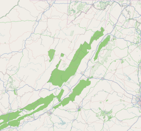
Municipalities and communities of Rockbridge County, Virginia, United States | ||
|---|---|---|
| Towns | 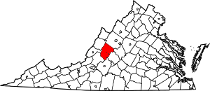 Map of Virginia highlighting Rockbridge County | |
| CDP | ||
| Unincorporated communities | ||
| Footnotes | ‡This populated place also has portions in an adjacent county or counties | |

| Authority control |
|
|---|