Salem, Virginia
Salem is an independent city in the U.S. commonwealth of Virginia. As of the 2010 census, the population was 24,802.[5] It is the county seat of Roanoke County,[6] although the two are separate jurisdictions. The Bureau of Economic Analysis combines the city of Salem with Roanoke County for statistical purposes.
Salem, Virginia | |
|---|---|
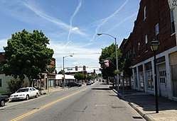 Main Street in Salem | |
 Seal | |
 Salem  Salem  Salem | |
| Coordinates: 37°17′12″N 80°3′21″W | |
| Country | United States |
| State | Virginia |
| County | None (Independent city) |
| Government | |
| • Mayor | Randy Foley |
| Area | |
| • Total | 14.62 sq mi (37.9 km2) |
| • Land | 14.52 sq mi (37.6 km2) |
| • Water | 0.11 sq mi (0.3 km2) |
| Elevation | 1,075 ft (358.14 m) |
| Population (2010) | |
| • Total | 24,802 |
| • Estimate (2019)[2] | 25,301 |
| • Density | 1,700/sq mi (660/km2) |
| Time zone | UTC−5 (EST) |
| • Summer (DST) | UTC−4 (EDT) |
| FIPS code | 51-70000[3] |
| GNIS feature ID | 1498533[4] |
| Website | http://www.salemva.gov/ |
Salem is bordered by the city of Roanoke and is included in the same Metropolitan Statistical Area. The city is located approximately 30 miles (48 km) from Blacksburg, 104 miles (167 km) from Greensboro, North Carolina, 120 miles (190 km) from Charlottesville, and 250 miles (400 km) from Knoxville, Tennessee.
Roanoke College is located in the city. The Division III Men's Basketball Championship and Stagg Bowl are held there annually, though the latter is scheduled to relocate beginning in 2018. Salem is also the home to a minor league baseball team, the Salem Red Sox, formerly the Salem Avalanche.
History
The earliest history of Salem exists as archaeological evidence of Native American tribes from as far back as 8000 B.C. until the middle of the 18th century. Europeans first explored the area of Salem in 1671, when the Siouan-speaking Totero people had a village nearby.[7] Explorers Thomas Batts and Robert Fallam gave the area its first recorded name: Totero Town, after this tribe, who supplied them with a guide to help with further exploration. Fort Lewis, named for General Andrew Lewis, of what is now Roanoke County, was built west of the town in 1752. Salem's Andrew Lewis Middle School (formerly Andrew Lewis High School) was named after General Lewis. Salem became a small settlement serving travelers on the Great Road (roughly the same path followed by US-11 and later Interstate 81 today) and was officially founded in 1802, receiving its charter in 1806. It is not known why the town was named Salem; the most widely accepted explanation is that it was named to honor William Bryan, a prominent citizen, who had moved from Salem, New Jersey.
Salem was attacked twice by the Union Army during the American Civil War, but its Salem Flying Artillery is said to have fired the last Confederate shot at Appomattox Court House prior to Robert E. Lee's surrender.
One of the city's four elementary schools is named after African American scientist G. W. Carver. Before integration, this was the high school for African Americans in Salem.
Salem annexed South Salem in 1953 and also an eastern tract in 1960, giving it a population of 16,058 – making it Virginia's largest town at the time. Salem officially became a city on December 31, 1967, to avoid the possibility of annexation into the city of Roanoke. Per the Virginia constitution, it was separated from Roanoke County. However, it remains the county seat.
Salem has been the home of two colleges. In 1847, the Virginia Institute, a boy's preparatory school, moved to Salem from Staunton. It received a college charter in 1853 and was renamed Roanoke College for the Roanoke Valley. The college is located in central Salem, one block north of Main Street. Roanoke Women's College, later named Elizabeth College, operated between 1912 and 1922. The college burned in late 1921 and did not reopen. Like Roanoke College, it was affiliated with the Evangelical Lutheran Church in America. The Elizabeth College campus is now the site of residence halls and athletic fields that belong to Roanoke College.
Salem is home to the Salem Red Sox, a High Class-A affiliate to the Boston Red Sox. The Amos Alonzo Stagg Bowl, the NCAA Division III Football Championship game was held at Salem Football Stadium between 1993 and 2016. Salem's success in holding that event led the NCAA to also move the NCAA Men's Division III Basketball Championship and the NCAA Division III Volleyball Championship to the Salem Civic Center and the Women's NCAA Division III Softball Championship to Moyer Field. In August 2007, the Salem Football Stadium also hosted the Southwestern Virginia Educational Classic. This game is played annually in the Roanoke Valley and consists of two football teams from Historically Black Colleges and Universities. The city hosts several other statewide, regional, and national sporting events at its facilities. These events are attracted by the city's hospitality, modern facilities and overall support. Salem High School, is also known for its athletic programs, particularly the football team which has won nine state championships since 1996, and also the forensics team, which has won fourteen consecutive state championships.
Geography
Salem is located at 37°17′12″N 80°3′21″W (37.286895, -80.055836).
According to the United States Census Bureau, the city has a total area of 14.5 square miles (37.6 km2), of which 14.4 square miles (37.3 km2) is land and 0.1 square miles (0.3 km2) (0.7%) is water.[8]
Demographics
| Historical population | |||
|---|---|---|---|
| Census | Pop. | %± | |
| 1860 | 612 | — | |
| 1870 | 1,355 | 121.4% | |
| 1880 | 1,759 | 29.8% | |
| 1890 | 3,279 | 86.4% | |
| 1900 | 3,412 | 4.1% | |
| 1910 | 3,849 | 12.8% | |
| 1920 | 4,159 | 8.1% | |
| 1930 | 4,833 | 16.2% | |
| 1940 | 5,737 | 18.7% | |
| 1950 | 6,823 | 18.9% | |
| 1960 | 16,058 | 135.4% | |
| 1970 | 21,982 | 36.9% | |
| 1980 | 23,958 | 9.0% | |
| 1990 | 23,756 | −0.8% | |
| 2000 | 24,747 | 4.2% | |
| 2010 | 24,802 | 0.2% | |
| Est. 2019 | 25,301 | [2] | 2.0% |
| U.S. Decennial Census[9] 1790–1960[10] 1900–1990[11] 1990–2000[12] 2010–2013[5] | |||
As of the census[13] of 2000, there were 24,747 people, 9,954 households, and 6,539 families residing in the city. The population density was 1,696.4 people per square mile (654.9/km²). There were 10,403 housing units at an average density of 713.1 per square mile (275.3/km²). The racial makeup of the city was 91.88% White, 5.88% African American, 0.13% Native American, 0.97% Asian, 0.02% Pacific Islander, 0.25% from other races, and 0.86% from two or more races. Hispanic or Latino of any race were 0.83% of the population.
There were 9,954 households out of which 28.2% had children under the age of 18 living with them, 50.9% were married couples living together, 11.5% had a female householder with no husband present, and 34.3% were non-families. 29.0% of all households were made up of individuals and 12.2% had someone living alone who was 65 years of age or older. The average household size was 2.32 and the average family size was 2.84.
In the city, the population was spread out with 20.9% under the age of 18, 11.7% from 18 to 24, 26.7% from 25 to 44, 24.0% from 45 to 64, and 16.8% who were 65 years of age or older. The median age was 39 years. For every 100 females, there were 89.3 males. For every 100 females age 18 and over, there were 85.5 males.
The median income for a household in the city was $38,997, and the median income for a family was $47,174. Males had a median income of $32,472 versus $23,193 for females. The per capita income for the city was $20,091. About 4.3% of families and 6.7% of the population were below the poverty line, including 7.0% of those under age 18 and 8.1% of those age 65 or over.
Climate
The climate in this area is characterized by hot, humid summers and generally mild to cool winters. According to the Köppen climate classification system, Salem has a humid subtropical climate, abbreviated "Cfa" on climate maps.[14]
Notable people
- Dennis Haley, former NFL Linebacker for the Baltimore Ravens, New York Jets, and San Francisco 49ers.
- John McAfee, computer programmer and businessman.
- Marcus Parker, former Virginia Tech and NFL, Cincinnati Bengals running back.
- Ruth Painter Randall, biographer
- Billy Sample, former Major League baseball outfielder for the Texas Rangers, New York Yankees and Atlanta Braves; broadcaster and writer
- Leander J. Shaw, Jr., Chief Justice of the Florida Supreme Court, was born in Salem.[15]
- Adam Ward, photojournalist killed on live television while reporting for WDBJ7.
References
- "2018 U.S. Gazetteer Files". United States Census Bureau. Retrieved February 16, 2020.
- "Population and Housing Unit Estimates". Retrieved April 1, 2020.
- "U.S. Census website". United States Census Bureau. Retrieved January 31, 2008.
- "US Board on Geographic Names". United States Geological Survey. October 25, 2007. Retrieved January 31, 2008.
- "State & County QuickFacts". United States Census Bureau. Retrieved January 6, 2014.
- "Find a County". National Association of Counties. Retrieved June 7, 2011.
- Swanton, John R. (1952), The Indian Tribes of North America, Smithsonian Institution, p. 73, ISBN 0-8063-1730-2, OCLC 52230544
- "US Gazetteer files: 2010, 2000, and 1990". United States Census Bureau. February 12, 2011. Retrieved April 23, 2011.
- "U.S. Decennial Census". United States Census Bureau. Retrieved January 6, 2014.
- "Historical Census Browser". University of Virginia Library. Retrieved January 6, 2014.
- "Population of Counties by Decennial Census: 1900 to 1990". United States Census Bureau. Retrieved January 6, 2014.
- "Census 2000 PHC-T-4. Ranking Tables for Counties: 1990 and 2000" (PDF). United States Census Bureau. Retrieved January 6, 2014.
- "U.S. Census website". United States Census Bureau. Retrieved May 14, 2011.
- "Salem, Virginia Köppen Climate Classification (Weatherbase)". Weatherbase.
- Florida Supreme Court-Leander J. Shaw, Jr.
External links
| Wikimedia Commons has media related to Salem, Virginia. |
| Wikisource has the text of an 1879 American Cyclopædia article about Salem, Virginia. |
- Official website
- Roanoke College
- Community history
- . Encyclopædia Britannica (11th ed.). 1911.

| Authority control |
|---|