Craig County, Virginia
Craig County is a county located in the Commonwealth of Virginia. As of the 2010 census, the population was 5,190.[1] Its county seat is New Castle.[2]
Craig County | |
|---|---|
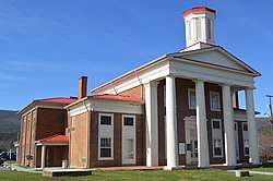 Craig County Courthouse in New Castle | |
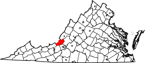 Location within the U.S. state of Virginia | |
 Virginia's location within the U.S. | |
| Coordinates: 37°29′N 80°13′W | |
| Country | |
| State | |
| Founded | 1851 |
| Named for | Robert Craig |
| Seat | New Castle |
| Largest town | New Castle |
| Area | |
| • Total | 331 sq mi (860 km2) |
| • Land | 330 sq mi (900 km2) |
| • Water | 1.1 sq mi (3 km2) 0.3% |
| Population (2010) | |
| • Total | 5,190 |
| • Estimate (2018) | 5,064 |
| • Density | 16/sq mi (6.1/km2) |
| Time zone | UTC−5 (Eastern) |
| • Summer (DST) | UTC−4 (EDT) |
| Congressional district | 9th |
| Website | www |
Craig County is part of the Roanoke, VA Metropolitan Statistical Area.
History
Nestled in the mountains of Southwest Virginia, Craig County was named for Robert Craig, a 19th-century Virginia congressman. Formed from parts of Botetourt, Roanoke, Giles, and Monroe (in present-day West Virginia) counties in 1851, Craig was later enlarged with several subsequent additions from neighboring counties.
The secluded, mountainous New Castle community, the county seat, has one of the commonwealth's antebellum court complexes, including a porticoed courthouse built in 1851. Craig Healing Springs, a collection of well-preserved early-20th-century resort buildings representative of the architecture of Virginia's more modest mountain spas, is located here.
Geography
According to the U.S. Census Bureau, the county has a total area of 330.6 square miles (856.3 km2), of which 329.5 square miles (853.4 km2) is land and 1.1 square miles (2.8 km2) (0.3%) is water.[3]
Adjacent counties
- Alleghany County – north
- Botetourt County – east
- Roanoke County – southeast
- Montgomery County – south
- Giles County – southwest
- Monroe County, West Virginia – west
National protected area
- Jefferson National Forest (part)
Demographics
| Historical population | |||
|---|---|---|---|
| Census | Pop. | %± | |
| 1860 | 3,553 | — | |
| 1870 | 2,942 | −17.2% | |
| 1880 | 3,794 | 29.0% | |
| 1890 | 3,835 | 1.1% | |
| 1900 | 4,293 | 11.9% | |
| 1910 | 4,711 | 9.7% | |
| 1920 | 4,100 | −13.0% | |
| 1930 | 3,562 | −13.1% | |
| 1940 | 3,769 | 5.8% | |
| 1950 | 3,452 | −8.4% | |
| 1960 | 3,356 | −2.8% | |
| 1970 | 3,524 | 5.0% | |
| 1980 | 3,948 | 12.0% | |
| 1990 | 4,372 | 10.7% | |
| 2000 | 5,091 | 16.4% | |
| 2010 | 5,190 | 1.9% | |
| Est. 2018 | 5,064 | [4] | −2.4% |
| U.S. Decennial Census[5] 1790–1960[6] 1900–1990[7] 1990–2000[8] 2010–2013[1] | |||
As of the census[9] of 2000, there were 5,091 people, 2,060 households, and 1,507 families residing in the county. The population density was 15 people per square mile (6/km²). There were 2,554 housing units at an average density of 8 per square mile (3/km²). The racial makeup of the county was 98.94% White, 0.20% Black or African American, 0.22% Native American, 0.16% Asian, 0.14% from other races, and 0.35% from two or more races. 0.33% of the population were Hispanic or Latino of any race.
There were 2,060 households out of which 30.80% had children under the age of 18 living with them, 61.90% were married couples living together, 7.00% had a female householder with no husband present, and 26.80% were non-families. 23.90% of all households were made up of individuals and 10.50% had someone living alone who was 65 years of age or older. The average household size was 2.45 and the average family size was 2.88.
In the county, the population was spread out with 23.60% under the age of 18, 6.40% from 18 to 24, 29.70% from 25 to 44, 26.70% from 45 to 64, and 13.60% who were 65 years of age or older. The median age was 40 years. For every 100 females there were 103.40 males. For every 100 females age 18 and over, there were 101.50 males.
The median income for a household in the county was $37,314, and the median income for a family was $41,750. Males had a median income of $26,713 versus $21,337 for females. The per capita income for the county was $17,322. About 6.60% of families and 10.30% of the population were below the poverty line, including 15.90% of those under age 18 and 10.50% of those age 65 or over.
Government
Board of Supervisors
- Craig City District: Rusty Zimmerman
- Craig Creek District: Casey McKenzie
- New Castle District: Jesse Spence (Vice Chair)
- Potts Mountain District: Carl Bailey
- Simmonsville District: Martha Murphy (Chair)[10]
Constitutional officers
- Clerk of the Circuit Court: Sharon P. Oliver (I)
- Commissioner of the Revenue: Elizabeth Huffman (I)
- Commonwealth's Attorney: Thaddeus R. Cox (I)
- Sheriff: Trevor Craddock (I)
- Treasurer: Jackie Parsons (I)[11]
Craig County is represented by Republican Stephen D. "Steve" Newman in the Virginia Senate, Republican Joe McNamara in the Virginia House of Delegates, and Republican H. Morgan Griffith in the U.S. House of Representatives.
Politics
| Year | Republican | Democratic | Third parties |
|---|---|---|---|
| 2016 | 76.7% 2,140 | 19.4% 541 | 3.9% 110 |
| 2012 | 65.9% 1,757 | 31.1% 830 | 3.0% 80 |
| 2008 | 64.7% 1,695 | 33.5% 877 | 1.9% 49 |
| 2004 | 65.1% 1,706 | 34.4% 901 | 0.5% 14 |
| 2000 | 63.4% 1,580 | 34.1% 851 | 2.5% 62 |
| 1996 | 45.4% 979 | 41.5% 895 | 13.2% 285 |
| 1992 | 43.9% 1,008 | 42.0% 965 | 14.1% 324 |
| 1988 | 55.5% 1,112 | 43.1% 864 | 1.5% 29 |
| 1984 | 57.7% 1,173 | 41.6% 845 | 0.7% 15 |
| 1980 | 43.2% 768 | 53.2% 946 | 3.7% 65 |
| 1976 | 32.8% 546 | 66.2% 1,103 | 1.1% 18 |
| 1972 | 63.4% 774 | 34.8% 425 | 1.7% 21 |
| 1968 | 46.2% 581 | 33.3% 419 | 20.5% 258 |
| 1964 | 38.3% 477 | 61.7% 767 | |
| 1960 | 44.8% 433 | 55.2% 534 | |
| 1956 | 48.8% 485 | 50.5% 501 | 0.7% 7 |
| 1952 | 46.5% 425 | 53.6% 490 | |
| 1948 | 39.8% 317 | 57.3% 456 | 2.9% 23 |
| 1944 | 36.7% 327 | 63.2% 564 | 0.1% 1 |
| 1940 | 31.2% 299 | 68.6% 656 | 0.2% 2 |
| 1936 | 37.7% 395 | 62.3% 653 | 0.1% 1 |
| 1932 | 31.3% 302 | 67.2% 649 | 1.6% 15 |
| 1928 | 48.0% 451 | 52.0% 489 | |
| 1924 | 36.0% 300 | 61.5% 512 | 2.5% 21 |
| 1920 | 45.1% 315 | 54.5% 381 | 0.4% 3 |
| 1916 | 35.0% 200 | 64.6% 369 | 0.4% 2 |
| 1912 | 11.2% 62 | 60.8% 337 | 28.0% 155 |
References
- "State & County QuickFacts". United States Census Bureau. Retrieved January 1, 2014.
- "Find a County". National Association of Counties. Archived from the original on May 31, 2011. Retrieved 2011-06-07.
- "US Gazetteer files: 2010, 2000, and 1990". United States Census Bureau. 2011-02-12. Retrieved 2011-04-23.
- "Population and Housing Unit Estimates". Retrieved July 14, 2019.
- "U.S. Decennial Census". United States Census Bureau. Retrieved January 1, 2014.
- "Historical Census Browser". University of Virginia Library. Retrieved January 1, 2014.
- "Population of Counties by Decennial Census: 1900 to 1990". United States Census Bureau. Retrieved January 1, 2014.
- "Census 2000 PHC-T-4. Ranking Tables for Counties: 1990 and 2000" (PDF). United States Census Bureau. Retrieved January 1, 2014.
- "U.S. Census website". United States Census Bureau. Retrieved 2011-05-14.
- "Board of Supervisors". Community and Government Portal. Craig County. Retrieved 7 September 2016.
- "Elected Officials". Community and Government Portal. Craig County. Retrieved 7 September 2016.
- Leip, David. "Dave Leip's Atlas of U.S. Presidential Elections". uselectionatlas.org. Retrieved 2018-08-18.
Places adjacent to Craig County, Virginia | ||||||||||
|---|---|---|---|---|---|---|---|---|---|---|
| ||||||||||
Municipalities and communities of Craig County, Virginia, United States | ||
|---|---|---|
| Town | Map of Virginia highlighting Craig County | |
| Unincorporated communities | ||

| Authority control |
|
|---|