Nassawadox, Virginia
Nassawadox is a town in Northampton County, Virginia, United States. The town, with an area of 0.4 square miles (1.0 km2), is located on U.S. Route 13 on Virginia's Eastern Shore, approximately five miles south of Exmore and 25 miles (40 km) north of the Chesapeake Bay Bridge-Tunnel.
Nassawadox, Virginia | |
|---|---|
.jpg) | |
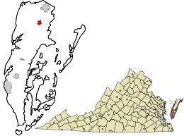 Location in Northampton County and the state of Virginia. | |
| Coordinates: 37°28′27″N 75°51′29″W | |
| Country | United States |
| State | Virginia |
| County | Northampton |
| Area | |
| • Total | 0.66 sq mi (1.7 km2) |
| • Land | 0.66 sq mi (1.7 km2) |
| • Water | 0.00 sq mi (0.0 km2) |
| Elevation | 36 ft (11 m) |
| Population (2010) | |
| • Total | 499 |
| • Estimate (2018)[2] | 479 |
| • Density | 760/sq mi (290/km2) |
| Time zone | UTC−5 (Eastern (EST)) |
| • Summer (DST) | UTC−4 (EDT) |
| ZIP code | 23413 |
| Area code(s) | 757, 948 (planned) |
| FIPS code | 51-54984[3] |
| GNIS feature ID | 1471328[4] |
History
The name derives from a word from a Native American language that means "land between two waters." Nassawadox is bounded on the east by the Atlantic Ocean and on the west by the Chesapeake Bay. The county is divided as is the town into bayside and seaside areas which refers to the land on either side of the highway, Route 13 (Lankford Highway) which runs through Accomack and Northampton Counties.
Highlighting its name and its location, Nassawadox has since 1993 hosted the annual October Between the Waters Bike Tour, which features bike tours of various lengths between the Eastern Shore's two coasts.
Brownsville and the Northampton Lumber Company Historic District are listed on the National Register of Historic Places.[5]
Demographics
| Historical population | |||
|---|---|---|---|
| Census | Pop. | %± | |
| 1960 | 650 | — | |
| 1970 | 591 | −9.1% | |
| 1980 | 630 | 6.6% | |
| 1990 | 564 | −10.5% | |
| 2000 | 572 | 1.4% | |
| 2010 | 499 | −12.8% | |
| Est. 2018 | 479 | [2] | −4.0% |
| U.S. Decennial Census[6] | |||
At the 2000 census there were 572 people, 186 households, and 121 families living in the town. The population density was 1,334.2 people per square mile (513.6/km²). There were 207 housing units at an average density of 482.8 per square mile (185.9/km²). The racial makeup of the town was 54.90% African American, 43.18% White, 0.87% Asian, and 1.05% from two or more races. Hispanic or Latino of any race were 1.22%.[3]
Of the 186 households 23.1% had children under the age of 18 living with them, 39.8% were married couples living together, 22.0% had a female householder with no husband present, and 34.9% were non-families. 31.2% of households were one person and 21.0% were one person aged 65 or older. The average household size was 2.33 and the average family size was 2.93.
The age distribution was 19.2% under the age of 18, 5.8% from 18 to 24, 14.7% from 25 to 44, 19.4% from 45 to 64, and 40.9% 65 or older. The median age was 54 years. For every 100 females, there were 81.0 males. For every 100 females age 18 and over, there were 69.2 males.
The median household income was $21,250 and the median family income was $27,500. Males had a median income of $25,000 versus $23,594 for females. The per capita income for the town was $14,626. About 24.0% of families and 32.8% of the population were below the poverty line, including 44.7% of those under age 18 and 18.9% of those age 65 or over.
Notable people
- Arthur "Big Boy" Crudup, bluesman in the 1940s and 1950s
- D. Page Elmore, former member of the Maryland House of Delegates
- Thom Henderson, creator of the popular ARC file format, which is the progenitor of the ZIP file format on computers.
- Ralph Northam, Governor of Virginia
- George van Driem, Dutch linguist
- Conny Van Dyke, actress
- Todd Washington, former NFL center for the Tampa Bay Buccaneers and the Houston Texans
- Johnnie Wittig, pitcher in Major League Baseball
Climate
The climate in this area is characterized by hot, humid summers and generally mild to cool winters. According to the Köppen Climate Classification system, Nassawadox has a humid subtropical climate, abbreviated "Cfa" on climate maps.[7]
References
- "2018 U.S. Gazetteer Files". United States Census Bureau. Retrieved Feb 16, 2020.
- "Population and Housing Unit Estimates". Retrieved June 4, 2019.
- "U.S. Census website". United States Census Bureau. Retrieved 2008-01-31.
- "US Board on Geographic Names". United States Geological Survey. 2007-10-25. Retrieved 2008-01-31.
- "National Register Information System". National Register of Historic Places. National Park Service. July 9, 2010.
- "Census of Population and Housing". Census.gov. Retrieved June 4, 2015.
- Climate Summary for Nassawadox, Virginia
| Authority control |
|---|