Pamplin City, Virginia
Pamplin City is a town in Appomattox and Prince Edward counties in the U.S. state of Virginia. The population was 219 at the 2010 census.
Pamplin City, Virginia | |
|---|---|
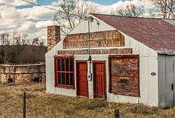 The Pamplin Pipe Factory, a federally designated historic site | |
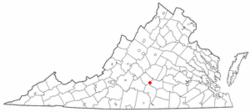 Location of Pamplin City, Virginia | |
| Coordinates: 37°15′49″N 78°40′52″W | |
| Country | United States |
| State | Virginia |
| Counties | Appomattox, Prince Edward |
| Government | |
| • Type | Elected Town Council |
| • Mayor | William Horton, Sarah Hamlett Blackwell |
| • Town Council | R. Jacob Hamlett |
| Area | |
| • Total | 0.32 sq mi (0.82 km2) |
| • Land | 0.32 sq mi (0.82 km2) |
| • Water | 0.00 sq mi (0.00 km2) |
| Population (2010) | |
| • Total | 219 |
| • Estimate (2018)[2] | 223 |
| • Density | 705.70/sq mi (272.79/km2) |
| Time zone | UTC-5 (Eastern (EST)) |
| • Summer (DST) | UTC-4 (EDT) |
| Federal Postal Code | 23958 |
| Area code(s) | 434 |
| FIPS code | 51-60488[3] |
The Appomattox County portion of Pamplin City is part of the Lynchburg Metropolitan Statistical Area.
History
Pamplin is the home of a Clay Pipe Factory, formerly the largest clay pipe factory in the United States. It is located to the side of Business 460. It was listed on the National Register of Historic Places (NRHP) in 1980.[4] The Buffalo Presbyterian Church was listed on the NRHP in 1995.[4]
This town was a stop on the Southside Railroad in the mid-nineteenth Century. This became the Atlantic, Mississippi and Ohio Railroad in 1870 and then a line in the Norfolk and Western Railway and now the Norfolk Southern Railway.[5] The rail line from Burkville to Pamplin City was converted by Virginia Department of Parks and Recreation into High Bridge Trail State Park.
The town has recently undergone a revitalization process. The Appomattox County library established an annex at the former Pamplin City Train Depot used by the Norfolk Southern Railroad. This renovated train depot now serves as a library and meeting place for the town; it is a center for holidays and other gatherings on special occasions.
Geography
Pamplin City is located at 37°15′49″N 78°40′52″W (37.263523, -78.680985).[6]
According to the United States Census Bureau, the town has a total area of 0.3 square miles (0.8 km²), all land.
Demographics
| Historical population | |||
|---|---|---|---|
| Census | Pop. | %± | |
| 1880 | 117 | — | |
| 1890 | 294 | 151.3% | |
| 1910 | 210 | — | |
| 1920 | 262 | 24.8% | |
| 1930 | 323 | 23.3% | |
| 1940 | 273 | −15.5% | |
| 1950 | 370 | 35.5% | |
| 1960 | 312 | −15.7% | |
| 1970 | 394 | 26.3% | |
| 1980 | 273 | −30.7% | |
| 1990 | 208 | −23.8% | |
| 2000 | 199 | −4.3% | |
| 2010 | 219 | 10.1% | |
| Est. 2018 | 223 | [2] | 1.8% |
| U.S. Decennial Census[7] | |||
At the 2000 census there were 199 people, 78 households, and 51 families in the town. The population density was 653.5 people per square mile (256.1/km²). There were 89 housing units at an average density of 292.3 per square mile (114.5/km²). The racial makeup of the town was 90.95% White, 7.54% African American, and 1.51% from two or more races. Hispanic or Latino of any race were 1.51%.[3]
Of the 78 households 34.6% had children under the age of 18 living with them, 44.9% were married couples living together, 14.1% had a female householder with no husband present, and 34.6% were non-families. 33.3% of households were one person and 21.8% were one person aged 65 or older. The average household size was 2.55 and the average family size was 3.27.
The age distribution was 31.2% under the age of 18, 7.5% from 18 to 24, 29.6% from 25 to 44, 12.6% from 45 to 64, and 19.1% 65 or older. The median age was 34 years. For every 100 females there were 91.3 males. For every 100 females age 18 and over, there were 77.9 males.
The median household income was $28,000 and the median family income was $36,250. Males had a median income of $23,125 versus $17,500 for females. The per capita income for the town was $15,246. About 16.7% of families and 19.0% of the population were below the poverty line, including 18.8% of those under the age of eighteen and 24.2% of those sixty five or over.
References
- "2018 U.S. Gazetteer Files". United States Census Bureau. Retrieved Feb 16, 2020.
- "Population and Housing Unit Estimates". Retrieved June 4, 2019.
- "U.S. Census website". United States Census Bureau. Retrieved 2008-01-31.
- "National Register Information System". National Register of Historic Places. National Park Service. July 9, 2010.
- Bright, David L. (2015). "Confederate Railroads - South Side". Confederate Railroads. Retrieved 2018-01-25.
- "US Gazetteer files: 2010, 2000, and 1990". United States Census Bureau. 2011-02-12. Retrieved 2011-04-23.
- "Census of Population and Housing". Census.gov. Retrieved June 4, 2015.
Municipalities and communities of Appomattox County, Virginia, United States | ||
|---|---|---|
| Towns |  Map of Virginia highlighting Appomattox County | |
| CDP | ||
| Other unincorporated communities | ||
| Footnotes | ‡This populated place also has portions in an adjacent county or counties | |
Municipalities and communities of Prince Edward County, Virginia, United States | ||
|---|---|---|
| Towns |  Map of Virginia highlighting Prince Edward County | |
| CDP | ||
| Unincorporated communities | ||
| Footnotes | ‡This populated place also has portions in an adjacent county or counties | |