Hugli-Chuchura
Hugli-Chuchura or Hooghly-Chinsurah is a city and a municipality of Hooghly district in the Indian state of West Bengal. It lies on the Hooghly River, 35 km north of Kolkata.[1] It is located in the district of Hooghly and is home to the district headquarters. Chuchura houses the Commissioner of the Burdwan Range. It is a part of the area covered by Kolkata Metropolitan Development Authority (KMDA).[2] The District Court building of Chinsurah is the longest building in West Bengal.
Hugli-Chuchura Hooghly-Chinsurah | |
|---|---|
.jpg) Ghorir More (Edwardian clock tower) | |
| Nickname(s): Chuchura | |
 Hugli-Chuchura  Hugli-Chuchura | |
| Coordinates: 22.90°N 88.39°E | |
| Country | |
| State | West Bengal |
| District | Hooghly |
| Region | Greater Kolkata |
| Establishment of Hooghly by Portuguese | 1537 |
| Establishment of Chinsurah by Dutch | 1456 |
| Establishment of Hooghly-Chinsurah Municipality | 1865 |
| Founded by | British |
| Government | |
| • Type | Municipality |
| • Body | Hooghly Chinsurah Municipality |
| • Chairman of Municipality | Gourikanta Mukherjee |
| Population (2015) | |
| • Total | 288,506 |
| Languages | |
| • Official | Bengali, English |
| Time zone | UTC+5:30 (IST) |
| PIN | 712101, 712102, 712103, 712104, 712105, 712106 |
| Telephone code | +91 33 |
| Vehicle registration | WB |
| Lok Sabha constituency | Hooghly |
| Vidhan Sabha constituency | Chunchura |
| Website | hooghly |
Chinsurah is the home to the new state-of-the-art 1000 KW DRM transmitter of Prasar Bharti which enables 'Akashvaani Maitree' to be broadcast across Bangladesh. This special Bangla service of All India Radio was launched in the wake of the Bangladesh Liberation Movement and played a key role during the war, broadcasting Indian news bulletins in Bangladesh. It continued till April 2010 but was discontinued thereafter due to decommissioning of the Super Power Transmitter at Chinsurah.[3] The headquarters of the Hooghly District Sports Association (HDSA) and the famous district Sadar hospital Imambara Sadar Hospital is situated here. Chinsurah is also the home of the oldest Armenian church in India and old Hindu Temples.
Etymology
.jpg)
Hooghly-Chuchura was a municipality formed by the merging of two towns, Hugli and Chinsura, in 1865. The names are spelled in other ways including Hooghly, Hugli, Hughli, Ugulim (in Portuguese), Chinsura, Chunchura, Chuchro and Chinsurah.
State Highway 6/ Grand Trunk Road (G.T. Road) passes through the town. Chuchura and Hooghly are historic stations on the Howrah-Bardhaman main line of the Eastern Railway. Ferry services across the Hooghly River serves as a link with the district of North 24 Parganas.
History
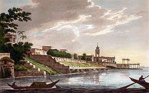
The Portuguese founded the town of Hooghly-Chuchura in 1579, but the district has thousands of years of heritage in the form of the great kingdom of Bhurshut. The city flourished as a trading port and some religious structures were built. One such structure is a Christian church dedicated to a statue of Mary, brought by the Portuguese.
In the 17th century, political disorder struck the city and the Mughal governor of Bengal expelled the Portuguese. The fleeing Portuguese lost the statue in the river, but local people later found it on the river bank. The arrested Portuguese were taken to Delhi, where a death sentence of trampling by elephants was decreed. When the emperor Shah Jahan heard this he ordered the priests released and granted a piece of land on the bank of the river Hooghly, where the statue of Mary was reestablished. There the Portuguese constructed a church to house the statue, which still receives pilgrims today. The church was renovated in the 1980s and has been declared as a basilica by the authority of Rome.
In 1656 the Dutch erected a factory on the site of the town.[1] At that time Calcutta was the principal settlement in Dutch Bengal, who used it as a base for Dutch intra-Asian trade in opium, saltpetre, spices, cotton and indigo.[1][4]
In 1759 the garrison of Chinsura, on its march to Chandernagore, attacked a British force under Colonel Forde.[1] The Battle of Chinsurah lasted less than half an hour and ended with the rout of the Dutch attackers.[1] In 1795, during the Napoleonic wars, a British garrison occupied the settlement.[1] The peace of 1814 restored Hughli to the Dutch. However, in 1825, the Dutch ceded many of their possession in India to the British, in exchange for the British possessions in Sumatra.[1]
Both Chinsurah and Hooghly played a role in the Bengal renaissance and the Indian independence movement. "Vande Mataram", India's national song, was composed by Bankim Chandra Chattopadhyay at Joraghat in Chinsurah, who had been an alumnus of the Hooghly Collegiate School. Nazrul Islam's revolutionary songs were penned while he was imprisoned by the British in Hooghly Jail.
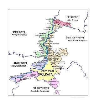
Geography
 |
| Cities and towns in the Chinsurah subdivision (except Polba Dadpur and Dhaniakhali CD Blocks) in Hooghly district M: municipal city/ town, CT: census town, R: rural/ urban centre, Owing to space constraints in the small map, the actual locations in a larger map may vary slightly |
Hooghly-Chuchura is at 22.90°N 88.39°E.[5] This city is on the flood plain on the right bank of river Bhagirathi-Hooghly.

Location
Hugli-Chuchura is located at 22.90°N 88.39°E.[6][7]
The area is composed of flat alluvial plains that forms part of the Gangetic Delta. The high west bank of the tidal Hooghly River is highly industrialised.[8]
Keota, Manushpur, Naldanga, Kodalia, Kulihanda, Dharmapur and Simla form a cluster of census towns on the eastern side of Hugli-Chuchura.[7]
Urbanisation
There are 13 statutory towns and 64 census towns in Hooghly district. The right bank of the Hooghly River has been industrialised over a long period. With foreigners dominating the area's industry, trade and commerce for over two centuries, it is amongst the leading industrialised districts in the state. At the same time the land is fertile and agricultural production is significant.[9]
In Chinsurah subdivision 68.63% of the population is rural and the urban population is 31.37%. It has 2 statutory and 23 census towns.[10] In Chinsurah Mogra CD Block 64.87% of the population is urban and 35.13% is rural. Amongst the four remaining CD Blocks in the subdivision two were overwhelmingly rural and two were wholly rural.[11]
The map alongside shows a portion of Chinsurah subdivision. All places marked in the map are linked in the larger full screen map.
Transportation

Hooghly-Chinsurah has three railway stations: Chinsurah railway station (CNS), Hooghly railway station (HGY) and Bandel Junction railway station (BDC) on the Howrah line and Hooghly Ghat railway station (HYG) on the Sealdah line. Thus Chinsurah is well connected to Howrah, Burdwan, Katwa, Naihati and other cities. A few passenger and express trains stop at the Chuchura station. The Hooghly Ghat station is beside the Sampreeti Bridge which is a connector between the eastern and the western side of the Ganges.
Transportation in Chinsurah is mainly covered by bus, auto, rickshaw and toto. Private Buses from Chinsurah Court stand[12] go to Chinsurah railway station (Bus no. 1) and other towns such as Dakshineswar (Bus no. 2), Memari (Bus no. 4), Kalna (Bus no. 8), Tarakeswar (Bus no. 17 and 23), Haripal (Bus no. 18) and Jirat (Bus no. 39). Besides Shuttle Buses (Without Numbers) up to Arambagh, Bardhaman, Bankura, Bishnupur, Jangipara, Digha etc. are also available. Auto service is provided to nearby towns and villages. Chinsurah Court-Chinsurah Railway Station, Chinsurah Court-Tribeni, Chinsurah Court-Bandel Junction Railway Station, Chinsurah Court-Hooghly railway station are the major auto routes in Hooghly-Chinsurah. Additionally, Chinsurah is well-connected to Naihati by ferry services.
Demographics
As per 2011 Census of India Hugli-Chinsurah had a total population of 179,931 of which 90,217 (50%) were males and 89,714 (50%) were females. Population below 6 years was 12,604. The total number of literates in Hugli-Chinsurah was 152,333 (91.04% of the population over 6 years).[13]
The following Municipalities and Census Towns in Hooghly district were part of Kolkata Urban Agglomeration in 2011 census: Bansberia (M), Hugli-Chinsurah (M), Bara Khejuria (Out Growth), Shankhanagar (CT), Amodghata (CT), Chak Bansberia (CT), Naldanga (CT), Kodalia (CT), Kulihanda (CT), Simla (CT), Dharmapur (CT), Bhadreswar (M), Champdani (M), Chandannagar (M Corp.), Baidyabati (M), Serampore (M), Rishra (M), Rishra (CT), Bamunari (CT), Dakshin Rajyadharpur (CT), Nabagram Colony (CT), Konnagar (M), Uttarpara Kotrung (M), Raghunathpur (PS-Dankuni) (CT), Kanaipur (CT) and Keota (CT).[14]
As of 2001 India census, Hugli-Chinsurah had a population of 170,201. Males constitute 51.06% of the population and females 48.94%. Hugli-Chinsurah has an average literacy rate of 82.55%, higher than the national average of 74.04%: male literacy is 87.93% and female literacy is 76.95%.[15]
Police stations
Chinsurah police station has jurisdiction over Hugli-Chuchura and Bansberia Municipal areas and a part of Chinsurah Mogra CD Block. Chinsurah police station has jurisdiction by Chandannagar Police Commissionerate. Chinsurah has a woman police station.[16][17]
Temples, churches and attractions

_by_Piyal_Kundu.jpg)
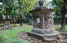
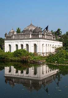
.jpg)
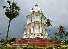
- Bandel Church
- Hooghly Imambara
- Dutch Cemetery, Chinsurah
- Armenian Church
Education
Primary and secondary education[18][19]
- Hooghly Collegiate School (established 1812), boys, Bengali language[20]
- Techno India Group Public School Co-ed[19]
- Don Bosco School, Bandel (established 1978), boys, English Medium School
- Chinsurah Deshbandhu Memorial High School, boys, Bengali Medium School
- Auxilium Convent School, Bandel, girls, English Medium School
- Chinsurah Duff High School (established 1849)
- Binodini Girls High School
- S.C. Shome Training Academy
- Chinsurah Balika Sikha Mandir
- Chinsurah Deshbandhu Memorial High School (Boys)
- Chinsurah Deshbandhu Memorial High School (Girls)
- Chinsurah Bharati Bidya Bhavan Girls High School
- Garbati High School
- Hooghly Girls High School
- Hooghly Branch (Govt) High School
- Hooghly Balika Banga Vidyalaya
- Ghutia Bazar Mattickbati Pathsala
- Sahaganj Shayaprosad Jatiya Vidyalaya
- Hooghly Jyotish Chandra Vidyapith (Boys)
- Chinsurah Balika Banimandir
- Bandel St.John’s High School
- Gourhari Harijan Vidyalaya
- Haronath Niroda Sundari Ghosh Vidyalaya
- Mearberh Ramkrishna Sikha Niketa
- Hooghly Jyotish Chandra Ghosh Balika Vidyalaya
- Elite Co-Ed
- Hooghly Deff & Dumb School
- Abot Sishu Hall
- Chinsurah English School[19]
Higher-education[21]
- Hooghly Engineering and Technology College
- Hooghly Institute of Technology
- West Bengal Survey Institute
- Hooghly Mohsin College
- Hooghly Women's College
- HooghlyGovt.TrainingCollege
- HooghlyIndustrialTrainingCollege
Festivals
Durga Puja, Eid, Jagadhatri Puja, Maharam, Kartick Puja, Kali Puja & Deepawali, Saraswati Puja, Lakshmi Puja, Navabarsho (Bengali New Year), Basanti Puja, Manasa Puja, Christmas, etc. are the main festivals celebrated here. Mohish Mordini puja is very famous festival. It started from "Jamai Sasti" and continue till 4days like Durga Puja. Mohish Mordini temple situated in Dharampur.The famous Gajan Festival is also celebrated at Sandeswartala Temple in Chinsurah near the banks of river Hooghly.
Notable residents
The town was home to prominent Bengali philanthropist Muhammad Mohsin. Notable figures associated with the town include Sarat Chandra Chattopadhyay, Bhudev Mukhopadhyay and novelist Kalikananda Abadhuta. Bankim Chandra Chattopadhyay wrote the national song of India in Joraghat (in Chinsurah).
See also
- Colonial India
- Dutch Cemetery, Chinsurah
- Dutch India
- European colonies in India
- Hooghly Chinsurah Municipality
References
- . Encyclopædia Britannica. 6 (11th ed.). 1911. p. 235.
- "Base Map of Kolkata Metropolitan area". Kolkata Metropolitan Development Authority. Archived from the original on 7 March 2007. Retrieved 3 September 2007.
- "AIR to re-launch radio channel for Bangladesh, plans joint content". Indian Express. Retrieved 7 July 2016.
- "The Dutch in Chinsurah". www.dutchinchinsurah.com. Retrieved 21 April 2017.
- "Yahoo maps location of Hugli-Chuchura". Yahoo maps. Retrieved 28 December 2008.
- "Yahoo maps location of Hugli-Chuchura". Yahoo maps. Retrieved 28 December 2008.
- "Census of India 2011, West Bengal: District Census Handbook, Hooghly" (PDF). Map of Chinsurah-Magra CD Block, page 469. Directorate of Census Operations, West Bengal. Retrieved 26 September 2018.
- "District Census Handbook: Hugli, Series-20, Part XIIA" (PDF). Physiography, Page 17-24. Directorate of Census Operations, West Bengal, 2011. Retrieved 28 September 2018.
- "District Census Handbook: Hugli, Series-20, Part XIIA" (PDF). Physical features: pages 20, 24. Directorate of Census Operations, West Bengal, 2011. Retrieved 27 September 2018.
- "District Statistical Handbook 2014 Hooghly". Table 2.1, 2.2, 2.4(a). Department of Statistics and Programme Implementation, Government of West Bengal. Retrieved 27 September 2018.
- "C.D. Block Wise Primary Census Abstract Data(PCA)". 2011 census: West Bengal – District-wise CD Blocks. Registrar General and Census Commissioner, India. Retrieved 27 September 2018.
- "Hooghly Buses".
- "2011 Census – Primary Census Abstract Data Tables". West Bengal – District-wise. Registrar General and Census Commissioner, India. Retrieved 15 June 2016.
- "Provisional Population Totals, Census of India 2011" (PDF). Constituents of Urban Agglomeration Having Population Above 1 Lakh. Census of India 2011. Retrieved 16 June 2016.
- "Census of India 2001: Data from the 2001 Census, including cities, villages and towns (Provisional)". Census Commission of India. Archived from the original on 16 June 2004. Retrieved 1 November 2008.
- "District Statistical Handbook 2014 Hooghly". Tables 2.1, 2.2. Department of Statistics and Programme Implementation, Government of West Bengal. Retrieved 3 October 2018.
- "Hooghly District Police". West Bengal Police. Archived from the original on 5 July 2017. Retrieved 20 June 2017.
- https://www.dbbandel.org/. Missing or empty
|title=(help) - "Official facebook page of Hooghly Collegiate School". Hooghly Collegiate School.
Bibliography
- Dey, S. C., "Hooghly Past and Present", The Calcutta Review, Vol.96, No.191, (January 1893), pp.22-42; No.192, (April 1893), 276-288; Vol.97, No.193, (July 1893), pp.71-81; No.194, (October 1893), 340-366;Vol.98, No.195, (January 1894), pp.152-170; Vol.99, No.197, (July 1894), pp.153-164; Vol.104, No.208, (April 1897), pp.355-373.
External links
| Wikimedia Commons has media related to Hugli-Chuchura. |
| Wikisource has the text of the 1911 Encyclopædia Britannica article Hugli (town). |
|  | |||||||||||||||||||||||||||||||||||||||||||||||||||||||||||||||||||||||
|
| ||||||||||||||||||||||||||||||||||||||||||||||||||||||||||||||||||||||||
| ||||||||||||||||||||||||||||||||||||||||||||||||||||||||||||||||||||||||
| ||||||||||||||||||||||||||||||||||||||||||||||||||||||||||||||||||||||||
| ||||||||||||||||||||||||||||||||||||||||||||||||||||||||||||||||||||||||
| ||||||||||||||||||||||||||||||||||||||||||||||||||||||||||||||||||||||||
| Kolkata Municipal Corporation |
|
|---|---|
| Kolkata Urban Agglomeration Outside KMC |
|
| |