Chinsurah subdivision
Chinsurah subdivision is an administrative subdivision of the Hooghly district in the state of West Bengal, India.
Chinsurah subdivision | |
|---|---|
Subdivision | |
.jpg) Bandel Church, founded in 1599, by the Portuguese, the oldest place of Christian worship in Bengal | |
 Chinsurah subdivision Location in West Bengal, India  Chinsurah subdivision Chinsurah subdivision (India) | |
| Coordinates: 22.90°N 88.39°E | |
| Country | |
| State | West Bengal |
| District | Hooghly |
| Headquarters | Hugli-Chuchura |
| Area | |
| • Total | 1,148.15 km2 (443.30 sq mi) |
| Population (2011) | |
| • Total | 1,657,518 |
| • Density | 1,400/km2 (3,700/sq mi) |
| Languages | |
| • Official | Bengali, English |
| Time zone | UTC+5:30 (IST) |
| ISO 3166 code | ISO 3166-2:IN |
| Vehicle registration | WB |
| Website | wb |
Overview
The eastern portion of Chinsurah subdivision is part of the Hooghly Flats, a natural physiographic region, that is a narrow strip of land along the Hooghly. The interior of the subdivision is part of the Hooghly-Damodar Plain, the agriculturally rich alluvial plains lying between the Hooghly and the Damodar. The entire area is a part of the Gangetic Delta. The Hooghly is a tidal river and has a high west bank. The Portuguese, the Dutch, the French, the Danes and the British dominated industry, trade and commerce in this area for more than two centuries, and as a result the Hooghly Flats region is highly industrialised.[1]
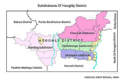
Subdivisions
The Hooghly district is divided into the following administrative subdivisions:[2]
| Subdivision | Headquarters | Area km2 | Population (2011) | Rural Population % (2011) | Urban Population % (2011) |
|---|---|---|---|---|---|
| Chinsurah | Hugli-Chuchura | 1,148.15 | 1,657,518 | 68.63 | 31.37 |
| Chandannagore | Chandannagar | 508.08 | 1,127,176 | 58.52 | 41.48 |
| Srirampore | Serampore | 422.45 | 1,469,849 | 26.88 | 73.12 |
| Arambag | Arambag | 1,058.87 | 1,264,602 | 94.77 | 5.23 |
| Hooghly district | Chinsurah | 3,149.00 | 5,519,145 | 61.43 | 38.57 |
 |
| Cities and towns in the Chinsurah subdivision (except Polba Dadpur and Dhaniakhali CD Blocks) in Hooghly district M: municipal city/ town, CT: census town, R: rural/ urban centre, Owing to space constraints in the small map, the actual locations in a larger map may vary slightly |
Administrative units
Chinsurah subdivision has 9 police stations, 5 community development blocks, 5 panchayat samitis, 69 gram panchayats, 756 mouzas, 741 inhabited villages, 2 municipalities, 1 outgrowth and 23 census towns. The municipalities are Hooghly Chinsurah Municipality and Bansberia Municipality. The census towns are: Kola, Hansghara, Raghunathpur, Madhusudanpur, Amodghata, Alikhoja, Shankhanagar, Chak Bansberia, Manushpur, Keota, Kodalia, Naldanga, Kulihanda, Dharmapur, Simla, Badhagachhi, Mirdhanga, Sripur, Jirat, Batika, Pandua, Purusattompur and Namajgram. The subdivision has its headquarters at Hugli-Chuchura.[3][4]
The right bank of the Hooghly River has been industrialised over a long period. With the leading European powers dominating the area's industry, trade and commerce for over two centuries, it is amongst the leading industrialised areas in the state. At the same time the land is fertile and agricultural production is significant.[5]
In Chinsurah Mogra CD Block 64.87% of the population is urban and 35.13% is rural. Amongst the four remaining CD Blocks in the subdivision two are overwhelmingly rural and two are wholly rural.[6]
The map alongside shows a portion of Chinsurah subdivision. All places marked in the map are linked in the larger full screen map.
Kolkata Urban Agglomeration
The following Municipalities, Outgrowth and Census Towns in Chinsurah subdivision were part of Kolkata Urban Agglomeration in the 2011 census: Hugli-Chinsurah (M), Bansberia (M), Bara Khejuria (Out Growth), Shankhanagar (CT), Amodghata (CT), Chak Bansberia (CT), Naldanga (CT), Kodalia (CT), Kulihanda (CT), Simla (CT), Dharmapur (CT) and Keota (CT).[7]
Police stations
Police stations in Chinsurah subdivision have the following features and jurisdiction:[8][9]
| Police station | Area covered km2 | Municipal town | CD Block |
|---|---|---|---|
| Dhaniakhali | n/a | - | Dhaniakhali (partly) |
| Gurap | n/a | - | Dhaniakhali (partly) |
| Pandua | n/a | - | Pandua |
| Balagarh | n/a | - | Balagarh |
| Chinsurah | n/a | Hugli-Chuchura, Bansberia | Chinsurah Mogra (partly) |
| Chinsurah (Women) | n/a | Hugli-Chuchura | - |
| Mogra | n/a | Bansberia | Chinsurah Mogra (partly) |
| Polba | n/a | - | Polba Dadpur |
| Dadpur | n/a | - | Polba Dadpur |
Blocks
Community development blocks in Chinsurah subdivision are:[2][6]
| CD Block | Headquarters | Area km2 | Population (2011) | SC % | ST % | Hindus % | Muslims % | Literacy Rate % | Census Towns |
|---|---|---|---|---|---|---|---|---|---|
| Balagarh | Patuligram, Jirat | 202.15 | 228,998 | 40.79 | 9.23 | 89.24 | 8.81 | 76.94 | 4 |
| Chinsurah Mogra | Mogra | 81.86 | 247,055 | 29.51 | 3.64 | 87.80 | 10.39 | 83.01 | 15 |
| Pandua | Pandua | 276.43 | 316,197 | 32.04 | 15.36 | 68.58 | 24.15 | 75.16 | 4 |
| Dhaniakhali | Dhaniakhali | 275.68 | 320,534 | 33.01 | 14.26 | 80.85 | 16.34 | 75.66 | - |
| Polba Dadpur | Barun Napara | 285.69 | 263,555 | 35.79 | 11.47 | 77.93 | 19.29 | 75.14 | - |
Gram panchayats
The subdivision contains 69 gram panchayats under 5 community development blocks:[10]
- Balagarh block consists of 13 gram panchayats, viz. Baklia Dhobapara, Ektarpur, Somra–I, Charkrishnabati, Guptipara–I, Somra–II, Dumurdaha Nityanandapur–I, Guptipara–II, Sripur–Balagarh, Jirat, Dumurdaha Nityanandapur–II, Mohipalpur and Sija Kamalpur.
- Chinsurah Mogra block consists of 10 gram panchayats, viz. Bandel, Debanandapur, Kodalia–II, Saptagram, Chandrahati–I, Digsui Hoyera, Mogra–I, Chandrahati–II, Kodalia–I and Mogra–II.
- Dhaniakhali block consists of 18 gram panchayats, viz. Belmuri, Dashghara–II, Gudubari–I, Perambua Sahabazar, Bhandarhati–I, Dhanekhali–I, Gudubari–II, Bhandarhati–II, Dhanekhali–II, Gurap, Somaspur–I, Bhastara, Gopinathpur–I, Khajudaha Milki, Somaspur–II, Dashghara–I, Gopinathpur–II and Mandra.
- Pandua block consists of 16 gram panchayats, viz. Bantika-Boinchee, Jamna, lchhobadaspur, Rameswarpur–Gopalnagar, Beloon Dhamasin, Jamnagar Mondalai, Panchagara–Toregram, Berela-Konchmali-Boragori , Jayer Dwarbasini, Shikhira Chanpta, Haral Daspur, Kshirkundi–Namajgram–Niyasa,Simlagarh Vitasin, Itachuna Khanyan and Sarai–Tinna.
- Polba Dadpur block consists of 12 gram panchayats, viz. Akhna, Dadpur, Mahanad, Rajhat, Amnan, Goswami Malipara, Makalpur, Satithan, Babnan, Harit, Polba and Sugandha.
Economy
Industry
Industries are concentrated in the cities and towns of the Chinsurah Mogra area (outside the CD Block area), along the Hooghly. In the 17th and 18th centuries different industrial units came into existence with the development of various European settlements along the Hooghly. Initially, it was traditional industries, but later comparatively heavier industries came in. Amongst the better known industrial units in Chinsurah subdivision are:[11]
- Dunlop India Ltd. opened its factory at Sahaganj in 1936 and it pioneered the manufacture of a number of products such as automobile and aeroplane tyres, and produced industrial belting later.[12] Pawan Kumar Ruia of the Ruia group, acquired Dunlop from Manu Chhabria’s Jumbo Group in 2005, but has been struggling ever since to restart the closed Sahaganj factory.[13]
- Tribeni Tissues is owned by Paper Boards and Speciality Papers Division of ITC Ltd. at Tribeni.[14]
- The 450 MW Bandel Thermal Power Station, operated by West Bengal Power Development Corporation, was established at Tribeni in 1983.[15]
- Ascon Agro Products Limited, jointly owned by the SPS Group and the Pailan Group, produces potato flakes at Dhaniakhali. It is locally marketed using the POTO brand. Potato flakes are used to make snacks and are also used as a thickening agent in soups and bakery products. The plant was inaugurated by Buddhadeb Bhattacharjee, the West Bengal chief minister, in 2007.[16][17][18][19][20]
- S.R.Industry, manufacturer of construction and agricultural machinery, was established at Pandua in 1996.[21]
Handloom weaving
The handloom sarees of Dhaniakhali, Begampur, Jangipara, Rajbalhat areas and dhutis of Haripal, Rajbalhat, Khanakul areas of Hooghly district are widely familiar.[22]
Agriculture
Hooghly is an agriculturally prosperous district of West Bengal. Although the economy has been shifting away from agriculture, it is still the pre-dominant economic activity and the main source of livelihood for the rural people of the district. One third of the district income comes from agriculture.[23] Given below is an overview of the agricultural production (all data in tonnes) for Chinsurah subdivision, other subdivisions and the Hooghly district, with data for the year 2013-14.[24]
| CD Block/ Subdivision | Rice | Wheat | Jute | Pulses | Oil seeds | Potatoes | Sugarcane |
|---|---|---|---|---|---|---|---|
| Dhaniakhali | 64,054 | 83 | 25,499 | - | 5,118 | 95,184 | - |
| Pandua | 40,707 | - | - | - | 865 | 288,975 | - |
| Balagarh | 57,671 | 4 | 80,440 | 4 | 2,176 | 60,285 | - |
| Chinsurah Mogra | 10,572 | 5 | 560 | - | 167 | 106,280 | - |
| Polba Dadpur | 65,557 | - | 4,719 | - | 2,036 | 262,084 | 162 |
| Chinsurah subdivision | 235,561 | 92 | 111,218 | 4 | 10,362 | 812,808 | 162 |
| Chandannagore subdivision | 189,791 | 12 | 136,276 | - | 6,522 | 313,692 | - |
| Srirampore subdivision | 126,852 | 11 | 39,820 | 12 | 8,058 | 436,111 | 2,437 |
| Arambag subdivision | 255,011 | 75 | 134,541 | 30 | 19,477 | 514,903 | 123,934 |
| Hooghly district | 807,215 | 190 | 421,855 | 46 | 44,419 | 2,077,514 | 126,533 |
Education
Hooghly district had a literacy rate of 81.80% as per the provisional figures of the census of India 2011. Chinsurah subdivision had a literacy rate of 79.17%, Chandannagore subdivision 83.01%, Srirampore subdivision 86.13% and Arambag subdivision 79.05. [25]
Given in the table below (data in numbers) is a comprehensive picture of the education scenario in Hooghly district for the year 2013-14:[25]
| Subdivision | Primary School |
Middle School |
High School |
Higher Secondary School |
General College, Univ |
Technical / Professional Instt |
Non-formal Education | |||||||
|---|---|---|---|---|---|---|---|---|---|---|---|---|---|---|
| Institution | Student | Institution | Student | Institution | Student | Institution | Student | Institution | Student | Institution | Student | Institution | Student | |
| Chinsurah | 899 | 85,213 | 46 | 3,885 | 98 | 48,722 | 109 | 124,068 | 7 | 16,342 | 26 | 10,564 | 2,413 | 45,289 |
| Chandannagore | 606 | 53,382 | 32 | 3,312 | 46 | 22,000 | 77 | 89,132 | 6 | 20,450 | 6 | 778 | 1,297 | 29,127 |
| Srirampore | 577 | 64,207 | 25 | 3,611 | 65 | 37,997 | 97 | 108,199 | 8 | 16,631 | 3 | 793 | 1,337 | 33,060 |
| Arambag | 935 | 80,705 | 49 | 5,462 | 83 | 48,513 | 76 | 91,911 | 7 | 16,950 | 3 | 228 | 1,838 | 57,383 |
| Hooghly district | 3,013 | 283,407 | 152 | 16,270 | 292 | 157,232 | 359 | 413,310 | 28 | 70,373 | 38 | 12,363 | 6,885 | 164,859 |
Note: Primary schools include junior basic schools; middle schools, high schools and higher secondary schools include madrasahs; technical schools include junior technical schools, junior government polytechnics, industrial technical institutes, industrial training centres, nursing training institutes etc.; technical and professional colleges include engineering colleges, medical colleges, para-medical institutes, management colleges, teachers training and nursing training colleges, law colleges, art colleges, music colleges etc. Special and non-formal education centres include sishu siksha kendras, madhyamik siksha kendras, centres of Rabindra mukta vidyalaya, recognised Sanskrit tols, institutions for the blind and other handicapped persons, Anganwadi centres, reformatory schools etc.[25]
The following institutions are located in Chinsurah subdivision:
- Hooghly Mohsin College was established at Chinsurah in 1836.[26][27]
- Hooghly Women's College was established at Chinsurah in 1949.[28][29]
- Hooghly Engineering and Technology College is an engineering college, established at Pipulhati in 2004.[30]
- Abacus Institute of Engineering and Management is an engineering college, established at Natungram, Mogra, in 2008.[31]
- Academy of Technology is an engineering college, established at Adisaptagram, Aedconagar in 2003.[32]
- Camelia Institute of Technology & Management, is an engineering college, established at Boinchi in 2009. It offers both degree and diploma courses.[33]
- Saroj Mohan Institute of Technology, is an engineering college, established at Guptipara in 2003.[34]
- Modern Institute of Engineering and Technology, is an engineering college, established at Barol-Malimpur, Rajhat (near Bandel) in 2010.[35]
- Bengal School of Technology was established in 2006 at Sugandha. It offers undergraduate and post graduate courses in pharmacy.
- Polba Mahavidyalaya, a general degree college, was established at Polba in 2005.[36][37]
- Balagarh Bijoy Krishna Mahavidyalaya (Jirat College), a general degree college, was established at Jirat in 1985.[38][39]
- Sarat Centenary College, a general degree college, was established at Dhaniakhali in 1978.[40][41]
- Bejoy Narayan Mahavidyalaya, a general degree college, was established at Itachuna in 1950.[42][43]
- Sreegopal Banerjee College, a general degree college, was established at Bagati, Mogra, in 1958.[44][45]
- Government Training College, a teacher's training college, established at Hugli-Chuchura in 1955.[46][47]
- Indira Gandhi Teachers’ Training College was established at Sultangachha, Pandua.[48]
Healthcare
The table below (all data in numbers) presents an overview of the medical facilities available and patients treated in the hospitals, health centres and sub-centres in 2014 in Hooghly district.[49]
| Subdivision | Health & Family Welfare Deptt, WB | Other State Govt Deptts |
Local bodies |
Central Govt Deptts / PSUs |
NGO / Private Nursing Homes |
Total | Total Number of Beds |
Total Number of Doctors* |
Indoor Patients |
Outdoor Patients | |||
|---|---|---|---|---|---|---|---|---|---|---|---|---|---|
| Hospitals |
Rural Hospitals |
Block Primary Health Centres |
Primary Health Centres | ||||||||||
| Chinsurah | 1 | 2 | 3 | 24 | - | - | - | 31 | 61 | 1,091 | 108 | 94,213 | 1,830,358 |
| Chandannagore | 1 | 3 | - | 8 | - | - | - | 41 | 53 | 828 | 56 | 70,724 | 1,105,060 |
| Srirampore | 3 | 2 | 2 | 12 | - | - | - | 80 | 99 | 1,894 | 85 | 63,619 | 1,252,941 |
| Arambag | 1 | 1 | 5 | 16 | - | - | - | 35 | 58 | 919 | 57 | 83,469 | 1,743,719 |
| Hooghly district | 6 | 8 | 10 | 60 | - | - | - | 187 | 271 | 4,732 | 306 | 312,025 | 5,932,078 |
.* Excluding nursing homes
Medical facilities in Chinsurah subdivision are as follows:
Hospitals in: (Name, location, beds)[50]
Hugli District Hospital, Hooghly Chinsurah Municipality, 550 beds
Chunchura Police Hospital, Hooghly Chinsurah Municipality, 98 beds
Hugli Jail Hospital, Hooghly Chinsurah Municipality, 27 beds
Bandel ESI Hospital, Chinsurah Mogra CD Block, PO Bandel, 250 beds
Bandel Railway Hospital, Polba Dadpur CD Block, PO Bandel, 4 beds
Bandel Thermal Power Station Hospital, Bansberia Municipality, PO Tribeni, 10 beds
Rural Hospitals: (Name, block, location, beds) [50]
Pandua Rural Hospital, Pandua CD Block, Pandua, 30 beds
Dhaniakhali Rural Hospital, Dhaniakhali CD Block, Dhaniakhali, 30 beds
Mogra Rural Hospital, Chinsurah Mogra CD Block, Mogra, 30 beds
Ahmedpur Rural Hospital, Balagarh CD Block, Patuligram, 30 beds
Polba Rural Hospital, Polba Dadpur CD Block, Polba, 30 beds
Primary Health Centres: (CD Block-wise)(CD Block, PHC location, beds)[50]
Chinsurah Mogra CD Block: Digsui (10 beds), R.N.Debdas (Naldanga), Bandel (6 beds)
Bansberia Municipality: Bansberia (5 beds)
Balagarh CD Block: Bakulia, Bakuliagram (6 beds), Dumurdaha-Nityanadapur, Gopalpur (10 beds), Guptipara (10 beds), Mohipalpur, Bridabanpur (4 beds), Sukharia, Somra (4 beds), Sripur-Bolagarh, Balagarh (10 beds)
Pandua CD Block: B.L.Mukherjee (Boinchigram), Boinchi (10 beds), Itachuna (10 beds), Dwarbasini (4 beds), Ramswarpur-Gopalnagar, Chandpur (10 beds), Haraldaspur, Hatni (10 beds), Jamgram (6 beds).
Polba Dadpur CD Block: Danarpur (10 beds), Makalpur (10 beds), Kamdebpur, Sugandha (4 beds).
Dhaniakhali CD Block: Bhandarhati (10 beds), Chopa (10 beds), Gurup, Palashi (10 beds), Porabazar (6 beds), Khejurdaha-Milki, Bhastara (10 beds).
Private Hospitals:* (Name, location, beds)[51]
Vivekananda Seva Sadan, Vill & PO Mandra, Dhaniakhali, 25 beds
Jannedra Memorial Child Health Care Hospital, Lions Club, Dhaniakhali, 25 beds
.* Excluding nursing homes
Electoral constituencies
Lok Sabha (parliamentary) and Vidhan Sabha (state assembly) constituencies in Chinsurah subdivision were as follows:[52]
| Lok Sabha constituency | Reservation | Vidhan Sabha constituency | Reservation | CD Block and/or Gram panchayats and/or municipal areas |
|---|---|---|---|---|
| Hooghly | None | Chunchura | None | Hooghly-Chunchura municipality and Bandel, Debanandapur, Kodalia I and Kodalia II gram panchayats of Chinsurah Mogra community development block, and Polba, Rajhat and Sugandha gram panchayats of Polba Dadpur CD Block |
| - | - | Balagarh | Reserved for SC | Balagarh CD Block and Chandrahati I, Chandrahati II, Digsui and Mogra I GPs of Chinsurah Mogra CD Block |
| - | - | Pandua | None | Pandua CD Block |
| - | - | Saptagram | None | Bansberia municipality, Aknna, Amnan, Goswami Malipara, Harit and Mahanad GPs of Polba Dadpur CD Block, and Mogra II and Saptagram gram panchayats of Chinsurah Mogra CD Block |
| - | - | Dhanekhali | Reserved for SC | Belmuri, Bhastara, Dashghara I, Dashghara II, Dhanekhali I, Dhanekhali II, Gurap, Gurbari I, Gurbari II, Khajurdaha Milki, Mandra, Somaspur I and Somaspur II GPs of Dhaniakhali CD Block, and Babnan, Dadpur, Makalpur and Satithan GPs of Polba-Dadpur CD Block |
| - | - | Other two assembly segments in Chandannagore subdivision | - | - |
References
- "District Census Handbook: Hugli, Series-20, Part XIIA" (PDF). Physiography, Page 17-24. Directorate of Census Operations, West Bengal, 2011. Retrieved 19 June 2017.
- "District Statistical Handbook 2014 Hooghly". Table 2.2, 2.4(a). Department of Statistics and Programme Implementation, Government of West Bengal. Retrieved 3 October 2018.
- "District Statistical Handbook 2014 Hooghly". Table 2.1. Department of Statistics and Programme Implementation, Government of West Bengal. Retrieved 6 October 2018.
- "Directory of District, Subdivision, Panchayat Samiti/ Block and Gram Panchayats in West Bengal". Hooghly - Revised in March 2008. Panchayats and Rural Development Department, Government of West Bengal. Retrieved 19 June 2017.
- "District Census Handbook: Hugli, Series-20, Part XIIA" (PDF). Physical features: pages 20, 24. Directorate of Census Operations, West Bengal, 2011. Retrieved 27 September 2018.
- "C.D. Block Wise Primary Census Abstract Data(PCA)". 2011 census: West Bengal – District-wise CD Blocks. Registrar General and Census Commissioner, India. Retrieved 24 October 2016.
- "Provisional Population Totals, Census of India 2011" (PDF). Constituents of Urban Agglomeration Having Population Above 1 Lakh. Census of India 2011. Retrieved 16 June 2017.
- "District Statistical Handbook 2014 Hooghly". Tables 2.1, 2.2. Department of Statistics and Programme Implementation, Government of West Bengal. Retrieved 3 October 2018.
- "Hooghly District Police". West Bengal Police. Retrieved 20 June 2017.
- "Directory of District, Subdivision, Panchayat Samiti/ Block and Gram Panchayats in West Bengal". Hooghly - Revised in March 2008. Panchayats and Rural Development Department, Government of West Bengal. Retrieved 20 June 2017.
- "District Human Development Report: Hooghly" (PDF). page 71. Development and Planning Department, Government of West Bengal, 2011. Archived from the original (PDF) on 7 August 2017. Retrieved 26 June 2017.
- "ET Markets". The Economic Times. Retrieved 26 June 2017.
- "Dunlop's Sahaganj factory a drag on group: Ruia". 25 October 2011. Live Mint. Retrieved 26 June 2017.
- "Paper Boards and Speciality Papers Division". ITC Ltd. Retrieved 26 June 2017.
- "West Bengal Power Development Corporation". Bandel Thermal Power Station. WBPDC. Retrieved 26 June 2017.
- "Pailan Group – Ascon Agro Products Ltd". potatoPRO.com. Retrieved 19 July 2017.
- "SPS buys Pailan food unit". Business Standard, 8 April 2008. Retrieved 19 July 2017.
- "SPS group acquires 55% of Pailan Arm". The Telegraph, 9 April 2008. Retrieved 19 July 2017.
- "Pailan group (India) exports potato flakes to Israel". potatoPRO.com, 19 December 2010. Retrieved 19 July 2017.
- "Pailan potato flakes unit launched". Business Standard. 8 October 2007. Retrieved 19 July 2017.
- "S.R.Industry". indiamart.com. Retrieved 14 July 2017.
- "District Human Development Report: Hooghly" (PDF). page 67. Development and Planning Department, Government of West Bengal, 2011. Archived from the original (PDF) on 7 August 2017. Retrieved 26 June 2017.
- "District Human Development Report: Hooghly" (PDF). page 58. Development and Planning Department, Government of West Bengal, 2011. Archived from the original (PDF) on 7 August 2017. Retrieved 26 June 2017.
- "District Statistical Handbook 2014 Hooghly". Tables 18.1. Data for subdivisions/ district calculated by totalling the CD Block data provided. Department of Statistics and Programme Implementation, Government of West Bengal. Retrieved 6 October 2018.
- "District Statistical Handbook 2014 Hooghly". Basic data: Table 4.4, 4.5, Clarifications: other related tables. Department of Statistics and Programme Implementation, Government of West Bengal. Retrieved 6 October 2016.
- "Hooghly Mohsin College". HMC. Retrieved 30 June 2017.
- "Hooghly Mohsin College". College Admission. Retrieved 30 June 2017.
- "Hooghly Women's College". HWC. Retrieved 30 June 2017.
- "Hooghly Women's College". College Admission. Retrieved 30 June 2017.
- "Hooghly Engineering and Technology College". HETC. Retrieved 30 June 2017.
- "Abacus Institute of Engineering and Management". AIEM. Retrieved 30 June 2017.
- "Academy of Technology". AOT. Retrieved 30 June 2017.
- "Camellia Institute of Technology and Management". CITM. Retrieved 30 June 2017.
- "Saroj Mohan Institute of Technology". SMITGP. Retrieved 30 June 2017.
- "Modern Institute of Engineering and Technology". MIET. Retrieved 30 June 2017.
- "Polba Mahavidyalaya". PM. Retrieved 30 June 2017.
- "Polba Mahavidyalaya". College Admission. Retrieved 30 June 2017.
- "Balagarh Bijoy Krishna Mahavidyalaya". BBKM. Retrieved 30 June 2017.
- "Balagarh Bejoy Krishna Mahavidyala". College Admission. Retrieved 30 June 2017.
- "Sarat Centenary College". SCC. Retrieved 30 June 2017.
- "Sarat Centenary College". College Admission. Retrieved 30 June 2017.
- "Bejoy Narayan Mahavidyalaya". BNM. Retrieved 30 June 2017.
- "Bejoy Narayan Mahaviyalaya, Itachuna, Hooghly". College Admission. Retrieved 30 June 2017.
- "Sreegopal Banerjee College". SBC. Retrieved 30 June 2017.
- "Sreegopal Banerjee College". College Admission. Retrieved 30 June 2017.
- "Government Training College, Hooghly". GTC. Retrieved 30 June 2017.
- "Government Training College, Hooghly". College Admission. Retrieved 30 June 2017.
- "Indira Gandhi Teacher's Training College". College Dekho. Retrieved 30 June 2017.
- "District Statistical Handbook 2014 Hooghly". Table 3.1, 3.3. Department of Statistics and Programme Implementation, Government of West Bengal. Retrieved 6 October 2018.
- "Health & Family Welfare Department". Health Statistics. Government of West Bengal. Retrieved 15 July 2017.
- "Private Hospitals in Hooghly district" (PDF). The list includes Nursing Homes also, but below we are giving only Hospitals. Hooghly district administration. Retrieved 17 July 2017.
- "Delimitation Commission Order No. 18, 15 February 2006" (PDF). West Bengal. Election Commission of India. Retrieved 24 May 2017.