Rajpur Sonarpur
Rajpur Sonarpur, popularly known as Sonarpur, is a city and a municipality of the South 24 Parganas district in the Indian state of West Bengal. It is a part of the area covered by the Kolkata Metropolitan Development Authority (KMDA).[3] Rajpur and Sonarpur are two separate towns. Since the formation of the municipality, these two towns are known together as Rajpur Sonarpur.
Rajpur Sonarpur | |
|---|---|
City | |
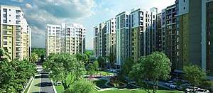 Skyline View of Rajpur Sonarpur from a Residential Project | |
 Rajpur Sonarpur Location in West Bengal  Rajpur Sonarpur Location in India | |
| Coordinates: 22.4491°N 88.3915°E | |
| Country | |
| State | West Bengal |
| Division | Presidency |
| District | South 24 Parganas |
| Region | Greater Kolkata |
| Government | |
| • Type | Municipality |
| • Body | Rajpur Sonarpur Municipality |
| Area | |
| • Total | 49.26 km2 (19.02 sq mi) |
| Elevation | 9 m (30 ft) |
| Population (2011) | |
| • Total | 424,368 |
| • Density | 8,600/km2 (22,000/sq mi) |
| Languages | |
| • Official | Bengali[1][2] |
| • Additional official | English[1] |
| Time zone | UTC+5:30 (IST) |
| PIN | 700070, 700084, 700094, 700096, 700103, 700146, 700147, 700148, 700149, 700150, 700151, 700152, 700153, 700154 |
| Telephone code | +91 33 |
| Vehicle registration | WB-19 to WB-22, WB-95 to WB-99 |
| Lok Sabha constituency | Jadavpur |
| Vidhan Sabha constituency | Sonarpur Uttar, Sonarpur Dakshin |
| Website | www |
History
Many janapadas grew up along the old Bhagirathi channel from the ancient times till around the 16th century: Kalighat, Boral, Rajpur, Harinavi, Mahinagar, Baruipur, Baharu, Jaynagar, Majilpur, Chhatrabhog etc. Bipradas Pipilai's Manasavijaya, composed in 1495, mentions many places in this region. “Chand Sadagar, a merchant character of the Manasavijaya, reached Baruipur, from Kalighat, through the old Bhagirathi channel. From there he proceeded towards Chhatrabhog, and then traveling through Hatiagarh pargana reached the open sea.” Chaitanyadeva (1486-1534) also went through this route. Travelling by boat to Puri he halted at the village of Atisara, near Baruipur. "His last stoppage in 24 Parganas was at Chhatrabhog, now a village within the jurisdiction of the Mathurapur police station. Chhatrabhog seems to have been an important river-port on the old Bhagirathi channel." Rama Chandra Khan, the zamindar of Chhatrabhog, helped Chaitanyadeva to continue with his journey.[4]
The area was home to the feudatory landlords (jamindars). The name Rajpur has been thus derived from the Bengali words Rajar Puri (রাজার পুরী) to Rajpuri and in this form to the now Rajpur. Being on the banks of the Adi Ganga (Old Ganges), Rajpur was one of the major locations of Bengal at that time. The proximity to Kolkata's southern district and being on the banks of Adi Ganga, which is just across the river made the place to be well connected. The old jamindar's house in Rajpur Harinavi is like the Roy Choudhury's. The family stayed in Rajpur. The ancestral houses of Sarat Chandra Bose and Subhash Chandra Bose were at Kodalia, a neighbourhood in Rajpur. Both of them were members of the first 24 Parganas District Committee of the Congress Party, which was formed in 1921.[5]
Geography
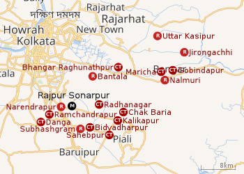 |
| Cities and towns in the northern part of Baruipur subdivision (including Sonarpur, Bhangar I & II CD blocks) in South 24 Parganas district M: municipal city/ town, CT: census town, R: rural/ urban centre, N: neighbourhood Owing to space constraints in the small map, the actual locations in a larger map may vary slightly |
Area overview
Baruipur subdivision is a rural subdivision with moderate levels of urbanization. 31.05% of the population lives in the urban areas and 68.95% lives in the rural areas. In the northern portion of the subdivision (shown in the map alongside) there are 10 census towns. The entire district is situated in the Ganges Delta and the northern part of the subdivision is a flat plain bordering the metropolis of Kolkata.[6][7][8]
Note: The map alongside presents some of the notable locations in the subdivision. All places marked in the map are linked in the larger full screen map.
Location
Rajpur Sonarpur is located at 22°26′57″N 88°23′29″E. It has an average elevation of 9 metres (30 ft).[9][10]
Danga and Ramchandrapur are adjacent to Rajpur Sonarpur on its south-eastern side, as per the map of the Sonarpur CD block in the District Census Handbook for the South 24 Parganas.[11]
Petua, Panchghara, Mallikpur and Hariharpur form a cluster of census towns in the Baruipur CD block, as per the map of the Baruipur CD block in the District Census Handbook for the South 24 Parganas.[12] This cluster has Rajpur Sonarpur on the east and Bidyadharpur on the north, both in Sonarpur CD block, as per map of Sonarpur CD block in the District Census Handbook for South 24 Parganas.[13]
Climate
Köppen-Geiger climate classification system classifies its climate as tropical wet and dry (Aw).
| Climate data for Rajpur Sonarpur | |||||||||||||
|---|---|---|---|---|---|---|---|---|---|---|---|---|---|
| Month | Jan | Feb | Mar | Apr | May | Jun | Jul | Aug | Sep | Oct | Nov | Dec | Year |
| Average high °C (°F) | 25.4 (77.7) |
27.7 (81.9) |
31.4 (88.5) |
33.1 (91.6) |
33.4 (92.1) |
32.3 (90.1) |
30.7 (87.3) |
30.8 (87.4) |
31.2 (88.2) |
30.8 (87.4) |
28.1 (82.6) |
25.1 (77.2) |
30.0 (86.0) |
| Daily mean °C (°F) | 19.9 (67.8) |
22.7 (72.9) |
27 (81) |
29.3 (84.7) |
30 (86) |
29.5 (85.1) |
28.5 (83.3) |
28.6 (83.5) |
28.5 (83.3) |
27.5 (81.5) |
23.5 (74.3) |
20 (68) |
26.3 (79.3) |
| Average low °C (°F) | 14.5 (58.1) |
17.7 (63.9) |
22.6 (72.7) |
25.6 (78.1) |
26.7 (80.1) |
26.8 (80.2) |
26.4 (79.5) |
26.4 (79.5) |
25.9 (78.6) |
24.2 (75.6) |
19 (66) |
14.6 (58.3) |
22.5 (72.6) |
| Average precipitation mm (inches) | 14 (0.6) |
17 (0.7) |
20 (0.8) |
34 (1.3) |
96 (3.8) |
244 (9.6) |
323 (12.7) |
322 (12.7) |
321 (12.6) |
172 (6.8) |
30 (1.2) |
1 (0.0) |
1,594 (62.8) |
| Source: Climate-Data.org (altitude: 9m)[14] | |||||||||||||
Demographics
| Population of Rajpur Sonarpur | |||
|---|---|---|---|
| Census | Population | %± | |
| 1901 | 10,713 | — | |
| 1911 | 11,607 | 8.3% | |
| 1921 | 11,412 | −1.7% | |
| 1931 | 11,433 | 0.2% | |
| 1941 | 13,614 | 19.1% | |
| 1951 | 16,310 | 19.8% | |
| 1961 | 24,812 | 52.1% | |
| 1971 | 34,393 | 38.6% | |
| 1981 | 43,985 | 27.9% | |
| 1991 | 60,175 | 36.8% | |
| 2001 | 336,707 | 459.5% | |
| 2011 | 424,368 | 26.0% | |
| Source:[15] | |||
According to the 2011 Census of India, Rajpur Sonarpur had a total population of 424,368, of which 215,405 (51%) were males and 208,963 (49%) were females. There were 35,274 persons in the age range of 0 to 6 years. The total number of literate persons was 350,721 which constituted 82.6% of the population with male literacy of 85.4% and female literacy of 79.8%. The effective literacy rate of 7+ population of Rajpur Sonarpur was 90.1%, of which male literacy rate was 93.2% and female literacy rate was 87.0%. The Scheduled Castes and Scheduled Tribes population was 78,655 and 2,340 respectively. Rajpur Sonarpur had 106604 households in 2011.[16]
Kolkata Urban Agglomeration
The following municipalities and census towns in the South 24 Parganas district were part of the Kolkata Urban Agglomeration in the 2011 census: Maheshtala (M), Joka (CT), Balarampur (CT), Chata Kalikapur (CT), Budge Budge (M), Nischintapur (CT), Uttar Raypur (CT), Pujali (M) and Rajpur Sonarpur (M).[17]
Civic Administration
Municipality
Rajpur Sonarpur Municipality covers an area of 49.26 km2. It has jurisdiction over the Rajpur Sonarpur city. The municipality was established in 1876. It is divided into 35 administrative wards. As per 2015 municipal election, it is being controlled by the All India Trinamool Congress.[18]
Police station
Sonarpur police station covers an area of 169.816 km2. It has jurisdiction over the Rajpur Sonarpur Municipality and the Sonarpur CD block.[19][20]
CD block HQ
The headquarters of the Sonarpur CD block are located at the Sonarpur.[21]
Transport
Rajpur Sonarpur is on the State Highway 1.[22]
Sonarpur Junction railway station is on the Sealdah–Namkhana line of the Kolkata Suburban Railway system.[22][23]
Commuters
With the electrification of the railways, suburban traffic has grown tremendously since the 1960s. As of 2005-06, more than 1.7 million (17 lakhs) commuters use the Kolkata Suburban Railway system daily. After the partition of India, refugees from erstwhile East Pakistan and Bangladesh had a strong impact on the development of urban areas in the periphery of Kolkata. The new immigrants depended on Kolkata for their livelihood, thus increasing the number of commuters. Eastern Railway runs 1,272 EMU trains daily.[24]
Education
Sonarpur Mahavidyalaya, established in 1985, is affiliated with the University of Calcutta. It offers honours courses in bengali, english, sanskrit, history, political science, philosophy, economics, geography, education, mathematics and accounting & finance, and general degree courses in arts, science, and commerce.[25]
Narendrapur Ramakrishna Mission Residential College, established in 1960, is affiliated with the University of Calcutta. It offers honours courses in bengali, english, sanskrit, history, political science, philosophy, economics, geography, education, mathematics and accounting & finance, and general degree courses in arts, science, and commerce.[26]
Narendrapur Ramakrishna Mission Blind Boys Academy, established in 1965, is affiliated with the University of Calcutta and is recognised by the Rehabilitation Council of India. It specialises in education/ teacher education. It has a hostel, a computer centre and a playground.[27]
Future Institute of Engineering and Management, established in 2001, offers diploma, undergraduate and postgraduate degree courses in Engineering and Technology and other allied fields.[28]
Netaji Subhash Engineering College, established in 1998, offers diploma, undergraduate and postgraduate degree courses in Engineering and Technology and other allied fields.[29]
Meghnad Saha Institute of Technology, established in 2001, offers diploma, undergraduate and postgraduate degree courses in Engineering and Technology and other allied fields.[30]
Sonarpur Bidyapith Up High School is a Bengali-medium coeducational school. It was established in 1965 and has facilities for teaching from class V to class XII.[31]
Sarada Vidyapith High School is a Bengali-medium coeducational school. It was established in 1995 and has facilities for teaching from class V to class XII.[32]
Kamrabad Uchcha Vidyalaya High School is a Bengali-medium coeducational school. It was established in 1948 and has facilities for teaching from class V to class XII.[33]
Kamrabad Girls High School is a Bengali-medium school for girls. It was established in 1924 and has facilities for teaching from class V to class XII.[34]
Gorkhara Vidyamandir Junior Hs Up Secondary School is a Bengali-medium coeducational school. It was established in 1970 and has facilities for teaching from class V to class X.[35]
A P Nagar Atul Krishna Roy Vidyayatan For Girls Up High School is a Bengali-medium school for girls. It was established in 1969 and has facilities for teaching from class V to class XII.[36]
Ghasiara Bidyapith Up High School is a Bengali-medium coeducational school. It was established in 1962 and has facilities for teaching from class V to class XII.[37]
Rajpur Vidyanidhi High School is a Bengali-medium school for boys. It was established in 1869 and has facilities for teaching from class V to class XII.[38]
Rajpur Padmamani Girls High School is a Bengali-medium school for girls. It was established in 1918 and has facilities for teaching from class V to class XII.[39]
Harinavi DVAS High School is a Bengali-medium coeducational school. It was established in 1866 and has facilities for teaching from class V to class XII.[40]
Harinavi Subhashini Balika Sikshalaya Up High School is a Bengali-medium school for girls. It was established in 1957 and has facilities for teaching from class V to class XII.[41]
Kodalia Prasanna Banga High School is a Bengali-medium coeducational school. It was established in 1963 and has facilities for teaching from class V to class XII.[42]
Kodalia Girls High School is a Bengali-medium school for girls. It was established in 1916 and has facilities for teaching from class V to class X.[43]
Subhashgram Nabatara Vidyalaya Up High School is a Bengali-medium coeducational school. It was established in 1986 and has facilities for teaching from class V to class XII.[44]
Satkari Banga Bidyalay Up Secondary School is a Bengali-medium coeducational school. It was established in 1966 and has facilities for teaching from class V to class X.[45]
Sri Ramakrishna Ashrama Institute Secondary School is a Bengali-medium coeducational school. It was established in 2004 and has facilities for teaching from class V to class X.[46]
Chouhati High School is a Bengali-medium coeducational school. It was established in 1962 and has facilities for teaching from class V to class XII.[47]
Jagaddal Colony High School is a Bengali-medium coeducational school. It was established in 1969 and has facilities for teaching from class V to class X.[48]
Jagaddal Uma Charan High School is a Bengali-medium school for boys. It was established in 1913 and has facilities for teaching from class V to class XII.[49]
Dakshin Jagaddal Srimati Kanak Basu Balika Vidyapith Up Secondary School is a Bengali-medium school for girls. It was established in 1953 and has facilities for teaching from class V to class X.[50]
Narendrapur Ramakrishna Mission Vidyalaya is a Bengali-medium school for boys. It was established in 1958 and has facilities for teaching from class V to class XII.[51]
Lions Calcutta Greater Vidya Mandir Secondary School is a English-medium coeducational school. It was established in 2002 and has facilities for teaching from class I to class X.[52]
Green Park Siksha Sadan High School is a Bengali-medium coeducational school. It was established in 1963 and has facilities for teaching from class V to class XII.[53]
B.D.M International is a English-medium coeducational school. It was established in 1966 and has facilities for teaching from class I to class XII.[54]
Future Campus School is a English-medium coeducational school. It was established in 2005 and has facilities for teaching from class I to class XII.[55]
Boral High School is a Bengali-medium coeducational school. It was established in 1888 and has facilities for teaching from class V to class XII.[56]
Boral Swamiji Bidyapith Up High School is a Bengali-medium coeducational school. It was established in 1965 and has facilities for teaching from class V to class XII.[57]
Boral Rishi Rajnarayan Girls High School is a Bengali-medium school for girls. It was established in 1959 and has facilities for teaching from class V to class XII.[58]
Laskarpur Vidyasagar Vidyapith Up High School is a Bengali-medium coeducational school. It was established in 1969 and has facilities for teaching from class V to class XII.[59]
Laskarpur Rabindra Vidyapith For Girls Up High School is a Bengali-medium school for girls. It was established in 1960 and has facilities for teaching from class V to class XII.[60]
Sripur Siksha Sadan Up Secondary School is a Bengali-medium coeducational school. It was established in 1967 and has facilities for teaching from class V to class X.[61]
Tegharia Bidyapith Up Secondary School is a Bengali-medium coeducational school. It was established in 1969 and has facilities for teaching from class V to class X.[62]
Kusamba High School is a Bengali-medium coeducational school. It was established in 1967 and has facilities for teaching from class V to class X.[63]
Tentulberia Anukul Chandra High School is a Bengali-medium school for boys. It was established in 1953 and has facilities for teaching from class V to class XII.[64]
Panchpota Badan Chandra Indumati High School is a Bengali-medium coeducational school. It was established in 1965 and has facilities for teaching from class V to class X.[65]
Mahamayapur Adarsha Vidyapith Up High School is a Bengali-medium coeducational school. It was established in 1959 and has facilities for teaching from class V to class XII.[66]
Balia Nafar Chandra Balika Vidyalaya Up High School is a Bengali-medium school for girls. It was established in 1957 and has facilities for teaching from class V to class XII.[67]
Garia Barada Prasad High School is a Bengali-medium coeducational school. It was established in 1919 and has facilities for teaching from class V to class XII.[68]
Garia Harimati Devi Girls High School is a Bengali-medium school for girls. It was established in 1955 and has facilities for teaching from class V to class XII.[69]
East Garia Educational Institution Secondary School is a English-medium coeducational school. It was established in 2006 and has facilities for teaching from class V to class X.[70]
Healthcare
Sonarpur Rural Hospital, with 25 beds, is the major government medical facility in the Sonarpur CD block.[71]
The Indian Institute of Liver and Digestive Sciences is a super speciality hospital that treats liver diseases. It has come up as a private initiative with government support.[72][73]
References
- "Fact and Figures". Wb.gov.in. Retrieved 5 July 2019.
- "52nd REPORT OF THE COMMISSIONER FOR LINGUISTIC MINORITIES IN INDIA" (PDF). Nclm.nic.in. Ministry of Minority Affairs. p. 85. Archived from the original (PDF) on 25 May 2017. Retrieved 5 July 2019.
- "Base Map of Kolkata Metropolitan Area". Kolkata Metropolitan Development Authority. Archived from the original on 28 September 2007. Retrieved 3 September 2007.
- "District Human Development Report: South 24 Parganas". Pages 3-4, Chapter I: South 24 Parganas: An overview. Department of Planning and Statistics, Government of West Bengal. Archived from the original on 5 October 2016. Retrieved 15 December 2019.
- "District Human Development Report: South 24 Parganas". Page 7, Chapter I: South 24 Parganas: An overview. Department of Planning and Statistics, Government of West Bengal. Archived from the original on 5 October 2016. Retrieved 15 December 2019.
- "District Statistical Handbook 2014 South Twety-four Parganas". Table 2.1 , 2.2, 2.4b. Department of Statistics and Programme Implementation, Government of West Bengal. Retrieved 5 December 2019.
- "Census of India 2011, West Bengal, District Census Handbook, South Twentyfour Parganas, Series – 20, Part XII-A, Village and Town Directory" (PDF). Page 13, Physiography. Directorate of Census Operations, West Bengal. Retrieved 5 December 2019.
- "District Human Development Report: South 24 Parganas". Chapter 9: Sundarbans and the Remote Islanders, p 290-311. Development & Planning Department, Government of West Bengal, 2009. Archived from the original on 5 October 2016. Retrieved 5 December 2019.
- Falling Rain Genomics, Inc - Rajpur
- Falling Rain Genomics, Inc - Sonarpur
- "Census of India 2011, West Bengal, District Census Handbook, South Twentyfour Parganas, Series – 20, Part XII-A, Village and Town Directory" (PDF). Page 257 - Map of Sonarpur CD block. Directorate of Census Operations, West Bengal. Retrieved 8 November 2019.
- "Census of India 2011, West Bengal, District Census Handbook, South Twentyfour Parganas, Series – 20, Part XII-A, Village and Town Directory" (PDF). Page 383 - Map of Baruipur CD block. Directorate of Census Operations, West Bengal. Retrieved 7 November 2019.
- "Census of India 2011, West Bengal, District Census Handbook, South Twentyfour Parganas, Series – 20, Part XII-A, Village and Town Directory" (PDF). Page 259 - Map of Sonarpur CD block. Directorate of Census Operations, West Bengal. Retrieved 7 November 2019.
- "Climate: Rajpur Sonarpur". Climate Data. Retrieved 14 January 2014.
- "District Census Handbook North Twenty Four Parganas, Census of India 2011, Series 20, Part XII A" (PDF). Section II Town Directory, Pages 781-783 Statement I: Growth History, Pages 799-803. Directorate of Census Operations V, West Bengal. Retrieved 12 December 2019.
- "Census of India: Rajpur Sonarpur". www.censusindia.gov.in. Retrieved 7 December 2019.
- "Provisional Population Totals, Census of India 2011" (PDF). Constituents of Urban Agglomeration Having Population Above 1 Lakh. Census of India 2011. Retrieved 7 November 2019.
- "Rajpur Sonarpur Municipality". Department of Municipal Affairs. Government of West Bengal. Archived from the original on 21 April 2017. Retrieved 18 May 2015.
- "Sonarpur police station". Baruipur police district. West Bengal police. Retrieved 18 October 2019.
- "District Statistical Handbook 2014 South 24 Parganas". Table No. 2.1. Department of Statistics and Programme Implementation, Government of West Bengal. Retrieved 18 October 2019.
- "BDO Offices under South 24 Parganas District". West Bengal Public Library Network, Government of West Bengal. Retrieved 18 October 2019.
- Google maps
- "34792 Sealdah-Namkhana Local". Time Table. India Rail Info. Retrieved 15 December 2019.
- Mondal, Bhaswati. "Commuting and Metropolitan Development of Kolkata". ResearchGate. Retrieved 16 December 2019.
- "Sonarpur Mahavidyalaya". SM. Retrieved 29 October 2019.
- "Ramakrishna Mission Residential College". RKMRC. Retrieved 29 October 2019.
- "Ramakrishna Mission Blind Boys Academy College". RKMBBA. Retrieved 30 October 2019.
- "Future Institute of Engineering and Management". FIEM. Retrieved 29 October 2019.
- "Netaji Subhash Engineering College". NSEC. Retrieved 29 October 2019.
- "Meghnad Saha Institute of Technology". MSIT. Retrieved 29 October 2019.
- "Sonarpur Bidyapith Up High School". ICBSE. Retrieved 1 January 2020.
- "Sarada Vidyapith High School". ICBSE. Retrieved 1 January 2020.
- "Kamrabad Uchcha Vidyalaya High School". ICBSE. Retrieved 1 January 2020.
- "Kamrabad Girls High School". ICBSE. Retrieved 1 January 2020.
- "Gorkhara Vidyamandir Junior Hs Up Secondary School". ICBSE. Retrieved 1 January 2020.
- "A P Nagar Atul Krishna Roy Vidyayatan For Girls Up High School". ICBSE. Retrieved 1 January 2020.
- "Ghasiara Bidyapith Up High School". ICBSE. Retrieved 1 January 2020.
- "Rajpur Vidyanidhi High School". ICBSE. Retrieved 1 January 2020.
- "Rajpur Padmamani Girls High School". ICBSE. Retrieved 1 January 2020.
- "Harinavi DVAS High School". ICBSE. Retrieved 1 January 2020.
- "Harinavi Subhashini Balika Sikshalaya Up High School". ICBSE. Retrieved 1 January 2020.
- "Kodalia Prasanna Banga High School". ICBSE. Retrieved 1 January 2020.
- "Kodalia Girls High School". ICBSE. Retrieved 1 January 2020.
- "Subhashgram Nabatara Vidyalaya Up High School". ICBSE. Retrieved 1 January 2020.
- "Satkari Banga Bidyalay Up Secondary School". ICBSE. Retrieved 1 January 2020.
- "Sri Ramakrishna Ashrama Institute Secondary School". ICBSE. Retrieved 1 January 2020.
- "Chouhati High School". ICBSE. Retrieved 1 January 2020.
- "Jagaddal Colony High School". ICBSE. Retrieved 1 January 2020.
- "Jagaddal U Charan High School". ICBSE. Retrieved 1 January 2020.
- "Dakshin Jagaddal Srimati Kanak Basu Balika Vidyapith Up Secondary School". ICBSE. Retrieved 1 January 2020.
- "Narendrapur Ramakrishna Mission Vidyalaya". RKMV. Retrieved 1 January 2020.
- "Lions Calcutta Greater Vidya Mandir Secondary School". ICBSE. Retrieved 1 January 2020.
- "Green Park Siksha Sadan High School". ICBSE. Retrieved 1 January 2020.
- "B D M International". BDMI. Retrieved 1 January 2020.
- "Future Campus School". FCS. Retrieved 1 January 2020.
- "Boral High School". ICBSE. Retrieved 1 January 2020.
- "Boral Swamiji Bidyapith Up High School". ICBSE. Retrieved 1 January 2020.
- "Boral Rishi Rajnarayan Girls High School". ICBSE. Retrieved 1 January 2020.
- "Laskarpur Vidyasagar Vidyapith Up High School". ICBSE. Retrieved 1 January 2020.
- "Laskarpur Rabindra Vidyapith For Girls Up High School". ICBSE. Retrieved 1 January 2020.
- "Sripur Siksha Sadan Up Secondary School". ICBSE. Retrieved 1 January 2020.
- "Tegharia Bidyapith Up Secondary School". ICBSE. Retrieved 1 January 2020.
- "Kusamba High School". ICBSE. Retrieved 1 January 2020.
- "Tentulberia Anukul Chandra High School". ICBSE. Retrieved 1 January 2020.
- "Panchpota Badan Chandra Indumati High School". ICBSE. Retrieved 1 January 2020.
- "Mahamayapur Adarsha Vidyapith Up High School". ICBSE. Retrieved 1 January 2020.
- "Balia Nafar Chandra Balika Vidyalaya Up High School". ICBSE. Retrieved 1 January 2020.
- "Garia Barada Prasad High School". ICBSE. Retrieved 1 January 2020.
- "Garia Harimati Devi Girls High School". ICBSE. Retrieved 1 January 2020.
- "East Garia Educational Institution Secondary School". ICBSE. Retrieved 1 January 2020.
- "Health & Family Welfare Department" (PDF). Health Statistics – Rural Hospitals. Government of West Bengal. Retrieved 7 January 2020.
- "Indian Institute of Liver and Digestive Sciences". Jaspital. Retrieved 7 January 2020.
- "Liver hospital to admit patients from May". The Telegraph, 5 April 2017. Retrieved 7 January 2020.
| Kolkata Municipal Corporation |
|
|---|---|
| Kolkata Urban Agglomeration Outside KMC |
|
| |