Malipukur
Malipukur is a Village in Chanditala I community development block in Srirampore subdivision of Hooghly district in the state of West Bengal, India. It is under Chanditala police station.[1]
Malipukur | |
|---|---|
Village | |
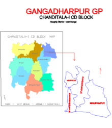
 Malipukur Location in West Bengal, India  Malipukur Malipukur (India) | |
| Coordinates: 22.7618937°N 88.2134692°E | |
| Country | |
| State | West Bengal |
| District | Hooghly |
| Government | |
| • Type | Panchayati raj (India) |
| • Body | Gangadharpur Gram panchayat |
| Population (2011) | |
| • Total | 945 |
| Languages | |
| • Official | Bengali, English |
| Time zone | UTC+5:30 (IST) |
| ISO 3166 code | IN-WB |
| Vehicle registration | WB |
| Lok Sabha constituency | Serampore |
| Vidhan Sabha constituency | Chanditala |
| Website | wb |
Geography
Malipukur is located at 22.7618937°N 88.2134692°E.

Gram panchayat

Villages and census towns in Gangadharpur gram panchayat are: Bankrishnapur, Gangadharpur, Malipukur and Manirampur.[2]
Market: Ganngadharpur Bazar, Hajaghata, Manirampur.
Demographics
As per 2011 Census of India, Malipukur had a total population of 945 of which 498 (53%) were males and 447 (47%) were females. Population below 6 years was 100. The total number of literates in Malipukur was 658 (77.87% of the population over 6 years).[3]
Transport
The nearest railway station is Baruipara railway station on the Howrah-Bardhaman chord which is a part of the Kolkata Suburban Railway system.
The main road is 31 Number Road It is the main artery of the town and it is connected to NH2 19 (old number NH 2)/ Durgapur Expressway and Grand Trunk Road.
There is 31 number bus service from Jangipara bus stand to Serampore bus stand via Sehakhala, Banmalipur, Gangadharpur, Baruipara, Bora.
References
- "banglarbhumi.gov.in". WEST BENGAL ->HUGLI(হুগলী) ->CHANDITALA-I (চণ্ডীতলা-১) Mouza Information. Government of West Bengal. Archived from the original on 22 December 2016. Retrieved 6 October 2018.
- "Bankrishnapur". Indian Village Directory. Retrieved 12 October 2018.
- "C.D. Block Wise Primary Census Abstract Data(PCA)". 2011 census: West Bengal – District-wise CD Blocks. Registrar General and Census Commissioner, India. Retrieved 7 October 2018.
Cities, towns and locations in Hooghly District | |||||||||
|---|---|---|---|---|---|---|---|---|---|
| Cities, municipal and census towns |
| ||||||||
| Locations other than cities and towns |
| ||||||||
| Neighbourhoods | |||||||||
| Related topics |
| ||||||||