Sodepur
Sodepur or Sodpur is a neighbourhood of Kolkata in the North 24 Parganas district of the Indian state of West Bengal. It is close to Kolkata and also a part of the area covered by Kolkata Metropolitan Development Authority (KMDA).
Sodepur Sodpur | |
|---|---|
Neighbourhood | |
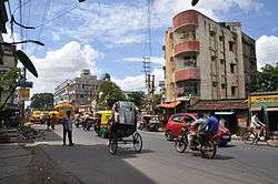 Amarabati Crossing Near Sodepur Rail Overbridge | |
 Sodepur Location in West Bengal, India  Sodepur Sodepur (India) | |
| Coordinates: 22°41′54″N 88°23′22″E | |
| Country | |
| State | West Bengal |
| Region | Greater Kolkata |
| District | North 24 Parganas |
| Government | |
| • Type | Municipality |
| • Body | Panihati Municipality |
| Elevation | 15 m (49 ft) |
| Languages | |
| • Official | Bengali, English |
| Time zone | UTC+5:30 (IST) |
| PIN | 700110, 700114, 700115 |
| Telephone code | +91 33 |
| Vehicle registration | WB |
| Lok Sabha constituency | Dum Dum |
| Vidhan Sabha constituency | Panihati |
History
There was once a community named Sayyid in this area from which the place was known as Sayyidpur or Sodepur.[1] Sodepur in the Barrackpore subdivision is historically famous for the Khadi Prathistan where historic decisions with regard to freedom struggle were taken by Gandhiji and other great leaders like Subhas Chandra Bose. In 1921, Satish Chandra Dasgupta, eminent chemist, resigned from Bengal Chemicals influenced by the Gandhian thought of Swadeshi and set up the ashram. This ashram near the Sodepur Railway Station has a special place in the history of the Indian independence movement. Mahatma Gandhi called this ashram his second home and stayed there at various times (1939, 1945, 1946, 1947).
Geography
 |
| Cities and towns in the southern portion of Barrackpore subdivision in North 24 Parganas district M: municipal city/ town, CT: census town, N: neighbourhood/ administrative location Owing to space constraints in the small map, the actual locations in a larger map may vary slightly |
Location
Sodepur is located at 22.698214°N 88.38947689999998°E.[2] It has an average elevation of 15 m (49 ft).
96% of the population of Barrackpore subdivision (partly presented in the map alongside, all places marked on the map are linked in the full screen map) lives in urban areas. In 2011, it had a density of population of 10,967 per km2. The subdivision has 16 municipalities and 24 census towns.[3]
For most of the cities/ towns information regarding density of population is available in the Infobox. Population data is not available for neighbourhoods. It is available for the entire Municipal area and thereafter ward-wise.
Police station
Ghola and Khardaha police station under Barrackpore Police Commissionerate has jurisdiction over Panihati and New Barrackpore Municipal areas.[4][5]
There is a police outpost at Sodepur.
Kolkata Urban Agglomeration
The following Municipalities, Census Towns and other locations in Barrackpore subdivision were part of Kolkata Urban Agglomeration in the 2011 census: Kanchrapara (M), Jetia (CT), Halisahar (M), Balibhara (CT), Naihati (M), Bhatpara (M), Kaugachhi (CT), Garshyamnagar (CT), Garulia (M), Ichhapur Defence Estate (CT), North Barrackpur (M), Barrackpur Cantonment (CB), Barrackpore (M), Jafarpur (CT), Ruiya (CT), Titagarh (M), Khardaha (M), Bandipur (CT), Panihati (M), Muragachha (CT) New Barrackpore (M), Chandpur (CT), Talbandha (CT), Patulia (CT), Kamarhati (M), Baranagar (M), South Dumdum (M), North Dumdum (M), Dum Dum (M), Noapara (CT), Babanpur (CT), Teghari (CT), Nanna (OG), Chakla (OG), Srotribati (OG) and Panpur (OG).[6]
Sodepur is a part of Panihati Municipality.[7]
Transport
.jpg)
Rail
Sodepur is well connected through Sodepur railway station on the Sealdah-Ranaghat line by the Eastern Railway suburban network.[8][9]
Commuters
Around a total of 32 lakh people from all around the city commute to Kolkata daily for work. In the Sealdah-Krishnanagar section there are 34 trains that carry commuters from 30 railway stations. In the Sealdah-Shantipur section 32 trains carry commuters from 29 stations.[10]
Road
The B.T. Road which passes through the heart of the town provides ample road transport. The Sodepur-Barasat Road also starts from here.[9] East and west parts of Sodepur are connected with a Rail Overbridge named Satish Dasgupta Setu (Sodepur Bridge), which was inaugurated in 1978.[11][12]
Bus
Private Bus
- 56 Howrah Station - Ruiya Purbapara
- 78 Esplanade - Barrackpore Court
- 78/1 Babughat - Rahara Bazar/Parthapur
- 81/1 Barasat - Rajchandrapur
- 214 Babughat - Sajirhat
- 214A Esplanade - Sodepur Girja
- DN43 Barasat Checkpost - Dakshineswar
WBTC Bus
CTC Bus
- C28 Barrackpore Court - Howrah Station
- C45 Ghola Muragacha - Howrah Station
CSTC Bus
- E32 Nilganj - Howrah Station
- S11 Nilganj - Esplanade
- S32 Barrackpore Court - Howrah Station
- S58 Barrackpore Court - Salt Lake Karunamoyee
- AC20 Barrackpore Court - Santragachi railway station (8 AM to 9 AM and afternoon 2 PM to 3 PM. In the Evening, the Bus plies from B.B.D. Bagh to Dunlop.)
Bus Routes Without Numbers
- Howrah Station - Madhyamgram
- Sodepur Girja - Uluberia Court
- Barrackpore Court - Salap
- Barrackpore Court - Mourigram railway station
- Lalkuthi - Howrah Station
Education
The oldest school at Sodepur is Sodepur High School which is affiliated to West Bengal Board. It was established in 1853.
The other schools here are:
- Natagarh Sri Sri Ramkrishna Vidyamandir (Ramkrishnapur), affiliated to West Bengal Board (Bengali medium)
- Swami Vivekananda Seva Sumity Vidhyalaya (Buniyadi School), affiliated to West Bengal Board (Bengali medium)
- Chandrachur Vidyapith, for boys, girls and primary, affiliated to West Bengal Board (Bengali medium)
- Sukchar Karmadaksha Chandrachur Vidyayatan, for boys, and primary, affiliated to West Bengal Board (Bengali medium)
- Sukchar Satadal balika vidyayatan, for girls, and primary, affiliated to West Bengal Board (Bengali medium)
- Desbandhu Sikshyatan, affiliated to West Bengal Board (Bengali medium)
- Sushil Chandra Balika Vidyalay, affiliated to West Bengal Board (Bengali medium)
- Central Point School affiliated to CISCE Board (English medium)
- Park Institution, affiliated to CISCE Board (English medium)
- National Model School, H.B. Town, affiliated to CISCE Board (English medium)
- St. Pauls, Amrabati, affiliated to CISCE Board (English medium)
- St. Xavier's Institution, affiliated to CISCE
- SUSHIL KRISHNA SIKSHAYATAN School (Bengali medium)
In the area of higher education, there are many colleges:
- Panihati Mahavidyalaya, affiliated to West Bengal State University, government-aided
- Guru Nanak Institute of Technology, private
- Guru Nanak Institute of Hotel Management, private
- Guru Nanak Institute of Dental Sciences and Research and Hospital, private
- Guru Nanak Institute of Pharmaceutical Science and Technology, private
- JIS University, private
Employment
The Skill Institute offers new approach to creating more employable youth in Bengal, by using a three-pronged approach of policy aggregation, skill development and job creation. It was started by London School of Economics and University College London alumni.
References
- http://www.panihatimunicipality.in/html/origin-name.html
- Falling Rain Genomics, Inc - Sodepur
- "District Statistical Handbook". North 24 Parganas 2013, Tables 2.1, 2.2, 2.4b. Department of Statistics and Programme Implementation, Government of West Bengal. Retrieved 2 May 2018.
- "District Statistical Handbook". North 24 Parganas 2013, Table 2.1. Department of Statistics and Programme Implementation, Government of West Bengal. Retrieved 11 June 2018.
- "Barrackpore Police Commissionerate". List of Police Stations with telephone numbers. West Bengal Police. Retrieved 11 June 2018.
- "Provisional Population Totals, Census of India 2011" (PDF). Constituents of Urban Agglomeration Having Population Above 1 Lakh. Census of India 2011. Retrieved 7 June 2018.
- ":: Welcome to Panihati Municipality ::". Panihatimunicipality.in. Retrieved 27 February 2014.
- "31311 Sealdah-Kalyani Simanta Local". Time Table. indiarailinfo. Retrieved 21 June 2018.
- Google maps
- Dey, Teesta. "The Suburban Railway Network of Kolkata: A Geographical Apprisal" (PDF). eTraverse, the Indian journal of spatial science, 2012. Retrieved 12 June 2018.
- "Sodepur Rail Overbridge".
- "Sodepur Bridge".
External links
| Wikimedia Commons has media related to Sodepur. |

- Sodepur Bazar website
North 24 Parganas district topics | |||||||||
|---|---|---|---|---|---|---|---|---|---|
| General |
| ||||||||
| Subdivisions | |||||||||
| Municipalities | |||||||||
| Community development blocks |
| ||||||||
| Rivers | |||||||||
| Transport |
| ||||||||
| Railway stations |
| ||||||||
| Institutes of higher learning |
| ||||||||
| Lok Sabha constituencies | |||||||||
| Vidhan Sabha constituencies |
| ||||||||
| Former Vidhan Sabha constituencies | |||||||||
| See also |
| ||||||||
| Kolkata Municipal Corporation |
|
|---|---|
| Kolkata Urban Agglomeration Outside KMC |
|
| |