Rajarhat
Rajarhat is a locality in Bidhannagar Municipal Corporation of North 24 Parganas district in the Indian state of West Bengal. It is close to Kolkata and also a part of the area covered by Kolkata Metropolitan Development Authority (KMDA). Lying just on the periphery of the planned New Town, Rajarhat-Gopalpur has seen huge spurt in real estate development.
Rajarhat | |
|---|---|
Neighbourhood | |
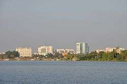 Skyline of Rajarhat | |
 Rajarhat Location in West Bengal, India  Rajarhat Rajarhat (India) | |
| Coordinates: 22°37′0″N 88°31′0″E | |
| Country | |
| State | West Bengal |
| District | North 24 Parganas |
| Region | Greater Kolkata |
| Government | |
| • Type | Municipal Corporation |
| • Body | Bidhannagar Municipal Corporation |
| Area | |
| • Total | 34.97 km2 (13.50 sq mi) |
| Population | |
| • Total | 402,844 |
| • Density | 12,000/km2 (30,000/sq mi) |
| Languages | |
| • Official | Bengali, English |
| Time zone | UTC+5:30 (IST) |
| PIN | 700052, 700059, 700101, 700102, 700136, 700157, 700159 |
| Telephone code | +91 33 |
| Vehicle registration | WB |
| Lok Sabha constituency | Dum Dum, Barasat |
| Vidhan Sabha constituency | Rajarhat Gopalpur, Rajarhat New Town |
| Website | north24parganas |
Etymology
Raja Gajendra Narayan Ray who was one of the Finance Officials under Emperor Jehangir settled in Haveli Shahar (now Halishahar). He had a vast zamindari in a large part of North 24 Parganas. One day he was going to visit his zamindari by a Bajra along the River Labanyabati (now a narrow canal called Nowai Khal). Suddenly by accident the Bajra sank & all the passengers except him drowned. After this accident he refused to return to Halishahar & decided to settle at this place. He built his residence there on the north of the River Labanyabati. Around his house a village grew up which is still known as Rajabaati or Raajbaari. This village is situated 2 km south of the villages of Jojera & Beraberi. Later many families of his subjects started to settle around the place and a market was also started which they called Raajaar Haat. This bazaar is still there situated east of Kadihati - Bishnupur Road & old Shyambazar - Basirhat Light Railwayline, now known as Baguiati - Rajarhaat Road. Raja Gajendra Narayan Ray's descendant, Durga Prasad Roy settled in Behala and he is considered to be the founder of the illustrious Ray Family of Behala.
Demographics
As per the 2011 census, Rajarhat-Gopalpur Municipality had a total population of 402,844 persons, Males constitute 50.55% of the population and females 49%.[2] Rajarhat-Gopalpur has an average literacy rate of 89.69%.
Administration
Rajarhat-Gopalpur Municipality had 35 wards.[3] It consisted of many localities such as: Kestopur, Chandiberia, Rabindra Pally, Samar Pally, Baguiati, Udayan Pally, Santosh Pally, Jagatpur, Ashwini Nagar, Narayantala, Raghunathpur, Arjunpur, Teghoria, Jyangra, Helabottala, Noapara, Adarsha Pally, Pramodgarh, Jyoti Nagar, Hatiara, Kaikhali, Chinar Park, Atghara, Dasadrone, Salua, Bablatala, Narayanpur, Beraberi, Bidisha Pally, Sarada Pally, Ganti and part of NSCBI Airport.[4] On 18 June 2015, Bidhannagar Municipal Corporation (BMC) was constituted by merging the existing municipal areas of Rajarhat-Gopalpur Municipality, Bidhannagar Municipality and the panchayat area of Mahishbathan II Gram Panchayat.[5] Now Rajarhat-Gopalpur has 26 wards (ward no. 1 to 26) under Bidhannagar Municipal Corporation.[6]
The area is under the jurisdiction of the Bidhannagar Police Commissionerate.
See also
- Rajarhat Gopalpur (Vidhan Sabha constituency)
- Rajarhat New Town (Vidhan Sabha constituency)
- New Town, Kolkata
- Rajarhat (community development block)
External links
![]()
References
- "North 24" (PDF). Archived from the original (PDF) on 5 February 2018.
- "http://www.census2011.co.in/census/city/217-rajarhat-gopalpur.html". Census of India, Government of India. External link in
|title=(help); Missing or empty|url=(help) - "Rajarhat-Gopalpur Municipality".
- "Bidhannagar Municipal Corporation about to be formed soon".
- Govt nod to new police posts, civic bodies’ merger The new corporation will thus be named Bidhannagar-Rajarhat-Gopalpur Municipal Corporation
- "BMC".
North 24 Parganas district topics | |||||||||
|---|---|---|---|---|---|---|---|---|---|
| General |
| ||||||||
| Subdivisions | |||||||||
| Municipalities | |||||||||
| Community development blocks |
| ||||||||
| Rivers | |||||||||
| Transport |
| ||||||||
| Railway stations |
| ||||||||
| Institutes of higher learning |
| ||||||||
| Lok Sabha constituencies | |||||||||
| Vidhan Sabha constituencies |
| ||||||||
| Former Vidhan Sabha constituencies | |||||||||
| See also |
| ||||||||
| Kolkata Municipal Corporation |
|
|---|---|
| Kolkata Urban Agglomeration Outside KMC |
|
| |