Baruipur
Baruipur is a city and a municipality of the South 24 Parganas district in the Indian state of West Bengal. It is a part of the area covered by the Kolkata Metropolitan Development Authority (KMDA).[3] It is the headquarters of the Baruipur subdivision and Baruipur police district.
Baruipur | |
|---|---|
City | |
 Baruipur Municipality | |
 Baruipur Location in West Bengal  Baruipur Location in India | |
| Coordinates: 22.3597°N 88.4318°E | |
| Country | |
| State | West Bengal |
| Division | Presidency |
| District | South 24 Parganas |
| Region | Greater Kolkata |
| Government | |
| • Type | Municipality |
| • Body | Baruipur Municipality |
| Area | |
| • Total | 9.50 km2 (3.67 sq mi) |
| Elevation | 9 m (30 ft) |
| Population (2011) | |
| • Total | 53,128 |
| • Density | 5,600/km2 (14,000/sq mi) |
| Languages | |
| • Official | Bengali[1][2] |
| • Additional official | English[1] |
| Time zone | UTC+5:30 (IST) |
| PIN | 700144, 700145 |
| Telephone code | +91 33 |
| Vehicle registration | WB-19 to WB-22, WB-95 to WB-99 |
| Lok Sabha constituency | Jadavpur |
| Vidhan Sabha constituency | Baruipur Purba (SC), Baruipur Paschim |
| Website | www |
History
Many janapadas grew up along the old Bhagirathi channel from the ancient times till around the 16th century: Kalighat, Boral, Rajpur, Harinavi, Mahinagar, Baruipur, Baharu, Jaynagar, Majilpur, Chhatrabhog etc. Bipradas Pipilai's Manasavijaya, composed in 1495, mentions many places in this region. “Chand Sadagar, a merchant character of the Manasavijaya, reached Baruipur, from Kalighat, through the old Bhagirathi channel. From there he proceeded towards Chhatrabhog, and then traveling through Hatiagarh pargana reached the open sea.” Chaitanyadeva (1486-1534) also went through this route. Travelling by boat to Puri he halted at the village of Atisara, near Baruipur. "His last stoppage in 24 Parganas was at Chhatrabhog, now a village within the jurisdiction of the Mathurapur police station. Chhatrabhog seems to have been an important river-port on the old Bhagirathi channel." Rama Chandra Khan, the zamindar of Chhatrabhog, helped Chaitanyadeva to continue with his journey.[4]
The Gajan utsab of Baruipur is famous. According to local legend, there was once a severely contested lathi fight between the lathials of the Sabarna Roy Choudhury of Barisha and the Roy Choudhury of Baruipur concerning the boundary dispute of their respective zamindaris. The Sardar of the lathials of the Sabarna Roy Choudhury was Bhriguram. The lathials of Baruipur managed to cut off his head with a sword and won the fight. However, Bhriguram was so much respected in the area that a lock of his hair was preserved. Bhriguram is still publicly honoured by the exposition of lock during the gajan mela at Baruipur.[5]
Geography
 |
| Cities and towns in the southern part of Baruipur subdivision (including Baruipur, Jaynagar I & II, Kultali CD blocks) in South 24 Parganas district M: municipal city/ town, CT: census town, R: rural/ urban centre, N: neighbourhood, H: historical place/ religious centre Places linked with coastal activity are marked in blue Owing to space constraints in the small map, the actual locations in a larger map may vary slightly |
Area overview
Baruipur subdivision is a rural subdivision with moderate levels of urbanization. 31.05% of the population lives in the urban areas and 68.95% lives in the rural areas. In the southern portion of the subdivision (shown in the map alongside) there are 20 census towns. The entire district is situated in the Ganges Delta and the southern part is covered by the Baruipur-Jaynagar Plain. Archaeological excavations at Dhosa and Tilpi, on the bank of the Piyali River indicate the existence of human habitation around 2,000 years ago.[6][7][8]
Note: The map alongside presents some of the notable locations in the subdivision. All places marked in the map are linked in the larger full screen map.
Location
Baruipur is located at 22°21′35″N 88°25′54″E. It has an average elevation of 9 metres (30 ft).[9]
Khodar Bazar on the west, Salipur on the north, Baruipur (CT) on the east are census towns adjacent to Baruipur, and Komarhat is a little away on the south, as per the map of the Baruipur CD block in the District Census Handbook for the South 24 Parganas.[10]
Climate
Köppen-Geiger climate classification system classifies its climate as tropical wet and dry (Aw).
| Climate data for Baruipur | |||||||||||||
|---|---|---|---|---|---|---|---|---|---|---|---|---|---|
| Month | Jan | Feb | Mar | Apr | May | Jun | Jul | Aug | Sep | Oct | Nov | Dec | Year |
| Average high °C (°F) | 25.4 (77.7) |
27.7 (81.9) |
31.4 (88.5) |
33.1 (91.6) |
33.4 (92.1) |
32.3 (90.1) |
30.7 (87.3) |
30.8 (87.4) |
31.2 (88.2) |
30.8 (87.4) |
28.1 (82.6) |
25.1 (77.2) |
30.0 (86.0) |
| Daily mean °C (°F) | 19.9 (67.8) |
22.7 (72.9) |
27 (81) |
29.3 (84.7) |
30 (86) |
29.5 (85.1) |
28.5 (83.3) |
28.6 (83.5) |
28.5 (83.3) |
27.5 (81.5) |
23.5 (74.3) |
20 (68) |
26.3 (79.3) |
| Average low °C (°F) | 14.5 (58.1) |
17.7 (63.9) |
22.6 (72.7) |
25.6 (78.1) |
26.7 (80.1) |
26.8 (80.2) |
26.4 (79.5) |
26.4 (79.5) |
25.9 (78.6) |
24.2 (75.6) |
19 (66) |
14.6 (58.3) |
22.5 (72.6) |
| Average precipitation mm (inches) | 14 (0.6) |
17 (0.7) |
20 (0.8) |
34 (1.3) |
96 (3.8) |
244 (9.6) |
323 (12.7) |
322 (12.7) |
321 (12.6) |
172 (6.8) |
30 (1.2) |
1 (0.0) |
1,594 (62.8) |
| Source: Climate-Data.org (altitude: 9m)[11] | |||||||||||||
Demographics
| Population of Baruipur | |||
|---|---|---|---|
| Census | Population | %± | |
| 1901 | 4,217 | — | |
| 1911 | 6,375 | 51.2% | |
| 1921 | 5,114 | −19.8% | |
| 1931 | 6,483 | 26.8% | |
| 1941 | 7,130 | 10.0% | |
| 1951 | 9,238 | 29.6% | |
| 1961 | 13,608 | 47.3% | |
| 1971 | 20,501 | 50.7% | |
| 1981 | 26,229 | 27.9% | |
| 1991 | 37,659 | 43.6% | |
| 2001 | 44,913 | 19.3% | |
| 2011 | 53,128 | 18.3% | |
| Source:[12] | |||
According to the 2011 Census of India, Baruipur had a total population of 53,128, of which 26,718 (50%) were males and 26,410 (50%) were females. There were 3,763 persons in the age range of 0 to 6 years. The total number of literate persons was 45,434 (92.04% of the population 7 years and above).[13]
Civic Administration
Municipality
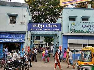
Baruipur Municipality covers an area of 9.50 km2. It has jurisdiction over the Baruipur city. The municipality was established in 1869. It is divided into 17 administrative wards. As per 2015 municipal election, it is being controlled by the All India Trinamool Congress.[14]
Transport
Baruipur is on the State Highway 1.[20]
Baruipur Junction railway station is on the Sealdah–Namkhana line of the Kolkata Suburban Railway system.[20][21]
Commuters
With the electrification of the railways, suburban traffic has grown tremendously since the 1960s. As of 2005-06, more than 1.7 million (17 lakhs) commuters use the Kolkata Suburban Railway system daily. After the partition of India, refugees from erstwhile East Pakistan and Bangladesh had a strong impact on the development of urban areas in the periphery of Kolkata. The new immigrants depended on Kolkata for their livelihood, thus increasing the number of commuters. Eastern Railway runs 1,272 EMU trains daily.[22]
Education
Baruipur College, established in 1981, is affiliated with the University of Calcutta. It offers honours courses in bengali, english, sanskrit, history, political science, philosophy, economics, geography, education, mathematics and accounting & finance, and general degree courses in arts, science, and commerce.[23]
Al Ameen Memorial Minority College, established in 2004, is affiliated with the University of Calcutta. It offers honours courses in bengali, english, arabic, islamic history & culture, philosophy and history, and a general course in arts.[24]
Baruipur Government Polytechnic, established in 2013, offers diploma, undergraduate and postgraduate degree courses in Engineering and Technology and other allied fields.[25]
South Calcutta Polytechnic, established in 2012, offers diploma, undergraduate and postgraduate degree courses in Engineering and Technology and other allied fields.[26]
Gargi Memorial Institute of Technology, established in 2011, offers diploma, undergraduate and postgraduate degree courses in Engineering and Technology and other allied fields.[27]
Greater Kolkata College of Engineering and Management, established in 2008, offers diploma, undergraduate and postgraduate degree courses in Engineering and Technology and other allied fields.[28]
Baruipur High School is a Bengali-medium school for boys. It was established in 1858 and has facilities for teaching from class V to class XII.[29]
Baruipur Girls' High School is a Bengali-medium school for girls. It was established in 1951 and has facilities for teaching from class V to class XII.[30]
Padmapukur Madhya Vidyalaya is a Bengali-medium coeducational school. It was established in 1954 and has facilities for teaching from class V to class X.[31]
Rasmoni Balika Vidyalaya is a Bengali-medium school for girls. It was established in 1948 and has facilities for teaching from class V to class XII.[32]
Madarat Popular Academy is a Bengali-medium school for boys. It was established in 1908 and has facilities for teaching from class V to class XII.[33]
Madarat Ishan Chandra Balika Vidyalaya is a Bengali-medium school for girls. It was established in 1964 and has facilities for teaching from class V to class XII.[34]
Welkin National School is a English-medium coeducational school. It was established in 2005 and has facilities for teaching from class I to class XII.[35]
Holy Cross School is a English-medium coeducational school. It was established in 1994 and has facilities for teaching from class I to class XII.[36]
St. Montfort's Senior Secondary School is a English-medium coeducational school. It was established in 2011 and has facilities for teaching from class I to class XII.[37]
Healthcare
Baruipur Subdivisional Hospital, with 100 beds, is the major government medical facility in the Baruipur subdivision.[38]
References
- "Fact and Figures". Wb.gov.in. Retrieved 5 July 2019.
- "52nd REPORT OF THE COMMISSIONER FOR LINGUISTIC MINORITIES IN INDIA" (PDF). Nclm.nic.in. Ministry of Minority Affairs. p. 85. Archived from the original (PDF) on 25 May 2017. Retrieved 5 July 2019.
- "Base Map of Kolkata Metropolitan Area". Kolkata Metropolitan Development Authority. Archived from the original on 28 September 2007. Retrieved 3 September 2007.
- "District Human Development Report: South 24 Parganas". Pages 3-4, Chapter I: South 24 Parganas: An overview. Department of Planning and Statistics, Government of West Bengal. Archived from the original on 5 October 2016. Retrieved 15 December 2019.
- "Hindu Books". Archived from the original on 27 June 2007. Retrieved 5 January 2007.
- "District Statistical Handbook 2014 South Twety-four Parganas". Table 2.1 , 2.2, 2.4b. Department of Statistics and Programme Implementation, Government of West Bengal. Archived from the original on 21 January 2019. Retrieved 5 December 2019.
- "Census of India 2011, West Bengal, District Census Handbook, South Twentyfour Parganas, Series – 20, Part XII-A, Village and Town Directory" (PDF). Page 13, Physiography. Directorate of Census Operations, West Bengal. Retrieved 5 December 2019.
- "District Human Development Report: South 24 Parganas". Chapter 9: Sundarbans and the Remote Islanders, p 290-311. Development & Planning Department, Government of West Bengal, 2009. Archived from the original on 5 October 2016. Retrieved 5 December 2019.
- Falling Rain Genomics, Inc - Baruipur
- "Census of India 2011, West Bengal, District Census Handbook, South Twentyfour Parganas, Series – 20, Part XII-A, Village and Town Directory" (PDF). Page 383 - Map of Baruipur CD block. Directorate of Census Operations, West Bengal. Retrieved 7 November 2019.
- "Climate: Baruipur". Climate Data. Retrieved 14 January 2014.
- "District Census Handbook North Twenty Four Parganas, Census of India 2011, Series 20, Part XII A" (PDF). Section II Town Directory, Pages 781-783 Statement I: Growth History, Pages 799-803. Directorate of Census Operations V, West Bengal. Retrieved 12 December 2019.
- "2011 Census – Primary Census Abstract Data Tables". West Bengal – District-wise. Registrar General and Census Commissioner, India. Archived from the original on 21 December 2016. Retrieved 27 April 2016.
- "Baruipur Municipality". Department of Municipal Affairs. Government of West Bengal. Archived from the original on 21 April 2017. Retrieved 18 May 2015.
- "Baruipur police station". Baruipur police district. West Bengal police. Retrieved 18 October 2019.
- "District Statistical Handbook 2014 South 24 Parganas". Table No. 2.1. Department of Statistics and Programme Implementation, Government of West Bengal. Archived from the original on 21 January 2019. Retrieved 17 October 2019.
- "Baruipur women police station". Baruipur police district. West Bengal police. Retrieved 18 October 2019.
- "BDO Offices under South 24 Parganas District". West Bengal Public Library Network, Government of West Bengal. Archived from the original on 3 October 2018. Retrieved 18 October 2019.
- "Census of India 2011, West Bengal, District Census Handbook, South Twentyfour Parganas, Series – 20, Part XII-A, Village and Town Directory" (PDF). Page 383 - Map of Baruipur CD block. Directorate of Census Operations, West Bengal. Retrieved 17 October 2019.
- Google maps
- "34792 Sealdah-Namkhana Local". Time Table. India Rail Info. Retrieved 15 December 2019.
- Mondal, Bhaswati. "Commuting and Metropolitan Development of Kolkata". ResearchGate. Retrieved 16 December 2019.
- "Baruipur College". BC. Retrieved 29 October 2019.
- "Al-Ameen Memorial Minority College". AAMMC. Retrieved 29 October 2019.
- "Baruipur Government Polytechnic". BGP. Retrieved 29 October 2019.
- "South Calcutta Polytechnic". SCP. Retrieved 29 October 2019.
- "Gargi Memorial Institute of Technology". GMIT. Retrieved 29 October 2019.
- "Greater Kolkata College of Engineering and Management". GKCEM. Retrieved 29 October 2019.
- "Baruipur High School". ICBSE. Retrieved 29 October 2019.
- "Baruipur Girls' High School". ICBSE. Retrieved 29 October 2019.
- "Padmapukur Madhya Vidyalaya". ICBSE. Retrieved 29 October 2019.
- "Rashmoni Balika Vidyalaya". ICBSE. Retrieved 29 October 2019.
- "Madarat Popular Academy". ICBSE. Retrieved 29 October 2019.
- "Madarat Ishan Chandra Balika Vidyalaya". ICBSE. Retrieved 29 October 2019.
- "Welkin National School". ICBSE. Retrieved 29 October 2019.
- "Holy Cross School". HCS. Retrieved 29 October 2019.
- "St. Montfort's Senior Secondary School". SMSSS. Retrieved 29 October 2019.
- "Health & Family Welfare Department" (PDF). Health Statistics - Hospitals. Government of West Bengal. Retrieved 17 December 2019.
| Kolkata Municipal Corporation |
|
|---|---|
| Kolkata Urban Agglomeration Outside KMC |
|
| |