Ghatal
Ghatal is a city and a municipality in Paschim Medinipur district, West Bengal, India. It is the headquarters of the Ghatal subdivision. Ghatal is a flood-prone area and in many years is flooded by the Shilabati River. The river Shilabati divided the city into two parts. The Ghatal Police station lies on the west bank of the river. There is one peculiar floating bridge on the river made of by joining some boats tied with rope from both sides in the banks, called "Bhasa Pool" (floating bridge). Also, one cement bridge is constructed on the main pitch road or State Highway 4 passing through Chandrakona Town, Ghatal, Daspur, and Mechogram.
Ghatal | |
|---|---|
City | |
 Birthplace of Ishwar Chandra Vidyasagar | |
 Ghatal Location in West Bengal, India  Ghatal Ghatal (India) | |
| Coordinates: 22.67°N 87.72°E | |
| Country | |
| State | West Bengal |
| District | Paschim Medinipur |
| Government | |
| • Type | Municipality |
| • Body | Ghatal Municipality |
| Elevation | 5 m (16 ft) |
| Population (2001) | |
| • Total | 51,586 |
| Languages | |
| • Official | Bengali, English |
| Time zone | UTC+5:30 (IST) |
| ISO 3166 code | IN-WB |
| Lok Sabha constituency | Ghatal |
| Vidhan Sabha constituency | Ghatal |
| Website | paschimmedinipur |
History
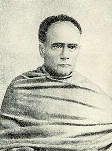
Ghatal Sub-Division and the town Ghatal have their old history of civilization, business, the struggle for freedom of India. Many patriots, social reformers, and freedom fighters were the sons of this PS area. The river Darakeswar and Shilabati meet at a place named as Bandar (port) 3 km (2 mi) East from Ghatal PS. This is the subdivision of Pandit Ishwar Chandra Vidyasagar, Patriot Pradyot Bhattacharya, Patriot Pravangsu Paul, Patriot Mohini Mondal, Raja Narendralal Khan, Patriot Manabendranath Roy and so many memorable persons.
In ancient times, Tamralipta was an important port for shipping export and import between Bengal and other countries including Sri Lanka. This Bandar of Ghatal was also used as a port for anchoring boats and ships with goods. Ghatal was once famous for the manufacture of cotton, tusser silk, bell-metal utensils, and earthenware. It was so important that the Dutch had a factory in the headquarters town, which is still used a
Geography
Ghatal is located at 22.67°N 87.72°E.[1] It has an average elevation of 5 metres (16 feet). It is situated on the sides of the river Shilabati on the south, Dwarakeswar on the east and Jhumi river another third side.
Demographics
As of 2001 India census,[2] Ghatal had a population of 51,586. Males constitute 52% of the population and females 48%. Ghatal has an average literacy rate of 76%, higher than the national average of 59.5%: male literacy is 83%, and female literacy is 69%. In Ghatal, 11% of the population is under 6 years of age.
As per the 2001 census, Ghatal CD Block had a population of 190,705 out of which 96,605 were males and 94,100 were females. Growth of population in the 1991-2001 decade was 11.83 per cent.[3]
CD Block HQ
The headquarters of Ghatal Block is located at Ghatal.[4]
Police station
Ghatal police station has jurisdiction over Ghatal and Kharar municipalities and Ghatal CD Block.[5][6]
Economy
Most of the rich and upper-middle-class people living in the town have old and established businesses. Besides the town area, the people of the nearby villages basically earn their livelihood by producing crops, like paddy, potato, wheat, jute and vegetables of different kinds. Some people earn money by fishing and hawking and weaving.
Climate
Its climate is moderate, but low lying areas of Ghatal are flood-prone areas and is flooded by the Shilaboti, Jhumi, Kethiya, Kansaboti and Rupnarayan Rivers during rainy season. On the other hand the other side of river Shilaboti is protected by. Rice, potato and other vegetable farming are the main occupations of the people of this subdivision.
Transportation
Ghatal is well connected by roads and highways with nearby cities like Kolkata, Howrah, Midnapore, Kanthi, Digha, Burdwan, Bankura. For local transportation buses (both state and private), minibusses, tempos and cycle-rickshaws are available. Panskura Railway Station is the nearest railway station. SH 4 passes through Ghatal.
Education
There are a number of well-known schools and colleges in Ghatal. For higher education, there is one general degree college named Ghatal Rabindra Satabarsiki Mahavidyalaya under Vidyasagar University, one polytechnic college named Ghatal Government Polytechnic and One ITI college named Ghatal Government ITI in Birsingha. The literacy rate of Ghatal is 76%. The schools are:
- Ghatal Vidyasagar High School
- Ghatal Yogoda Satsanga Sri Yukteswar Vidyapith
- Ghatal Basanta Kumari Girl's High School
Culture
The common people of this area maintained a culture something different from other parts of the district in conducting and observing their way of work in rituals and customs. They cherish their old fashion and customs. For example, the people celebrating the worship of Maa Sitala Buri and other Maa Sitalas in an around Ghatal Town used to carry hundreds of dhaks in procession and arrange open operas acting on the stage dragged and pushed by the men on pitch road running through the town.
Among many festivals in Ghatal Sishu Mela (around the month of February) is most popular. Many people of Ghatal town and its neighbouring blocks take part in the Sishu Mela. Vidyasagar Mela is also popular, which takes place in Birsingha (the birthplace of Iswarchandra Vidyasagar). The regular Bengali festivals like Durga Puja, Lakshmi Puja, Saraswati Puja and Kali Puja are well attended and observed with glorious themed pandals. Other common pujas in the worship of Sitala, Jagaddhatri, Holi, Janmastami, Bheema Puja, Jhulan also takes place.
Science exhibitions, seminars on science and literature, awareness programmes on health and agriculture are usually held in Ghatal Town hall. Besides that musical, dance and magic shows are also held in Ghatal Town hall.
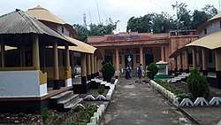
The Visalaxmi temple at Barada and Khipteswari temple at Ghatal are the main tourist attractions. There is one peculiar floating bridge on the river made of by joining some boats tied with rope from the both sides in the banks. This bridge is also called Bhasapool'(build in the times of British Raj), and is one of the greatest tourist attractions in Ghatal. There is also the Kushpata Satsanga Ashram. The largest Thakur Anukul Chandra temple of West Bengal is situated on the bank of Shilabati River which is 1.5 km (1 mi) away from Ghatal Vidyasagar Setu. Here one can see several temples of Anukul Thakur. There is a large prayer room for the common people. Everyday a huge number of people goes to the temple to worship the GOD, spend some great time with their families and enjoy the silence with beautiful greenary on the banks of river Shilabati. The peoples of the Ghatal are very religious. There are many ashramas like Anukul Thakurer Satsanga ashram, Nigamanand er ashram, Ramkrishna Mission, and Swami Debananda ashram.
Tourist spots
- Bhasapool (Pontoon Bridge) - Heritage of India
- Kushpata Satsanga Ashram of Anukul Thakur
- Visalaxmi Temple at Barada
- Birsingha - birthplace of Ishwar Chandra Vidyasagar
- Alamgunj Mosque
- Eco park- picnic destination
- Birsingha Bhagabati Vidyalaya (H.S) - established by Pandit Ishwar Vidyasagar
Notable people
- Akinchan Chakrabarty, 18th-century Bengali poet
- Ishwar Chandra Vidyasagar, social reformer who dedicated his life for basic education of the people, development of women education and reformation of educational structure as a whole; writer of Barnaparichay
References
- Falling Rain Genomics, Inc - Ghatal
- "Census of India 2001: Data from the 2001 Census, including cities, villages and towns (Provisional)". Census Commission of India. Archived from the original on 16 June 2004. Retrieved 1 November 2008.
- "Provisional population totals, West Bengal, Table 4, (erstwhile) Medinipur District". Census of India 2001. Census Commission of India. Archived from the original on 28 September 2011. Retrieved 22 December 2010.
- "District Census Handbook: Paschim Medinipur" (PDF). Map of Paschim Medinipur with CD Block HQs and Police Stations (on the fifth page). Directorate of Census Operations, West Bengal, 2011. Retrieved 20 November 2016.
- "District Statistical Handbook 2014 Paschim Medinipur". Tables 2.1, 2.2. Department of Statistics and Programme Implementation, Government of West Bengal. Archived from the original on 29 July 2017. Retrieved 14 October 2016.
- "District at a Glance". Paschim Medinipur District Police. Retrieved 27 October 2016.
Bibliography
- How India Clothed the World: The World of South Asian Textiles, 1500-1850. p. 240. ISBN 9789004176539. Retrieved 19 May 2016.
- Chatterjee, Gouripada. History of Bagree-Rajya (Garhbeta): With Special Reference to Its Anti-British Role, from Late 18th Century Till the Present Times. p. 141. ISBN 9788170990147.
- Midnapore, the Forerunner of India's Freedom Struggle. p. 100. Retrieved 19 May 2016.
- Das, Binod Sankar. Changing Profile of the Frontier Bengal, 1751-1833. p. 149. Retrieved 19 May 2016.
- District Handbooks: Malda. p. i. Retrieved 19 May 2016.
External links
- Ghatal website
- Official Daspur-II Block website
- Official Chandrakona-II Block website
- Paschim Medinipur District official website
- Purba Medinipur District official website
- Midnapore - website for East and West Midnapore
- Biography of Vidyasagar
- Iswarchandra Vidyasagar
Cities, towns and locations in Paschim Medinipur District | |||||||
|---|---|---|---|---|---|---|---|
| Cities, municipal and census towns |
| ||||||
| Locations other than cities and towns |
| ||||||
| Related topics |
| ||||||