Dakshin Rajyadharpur
Dakshin Rajyadharpur is a census town in Sreerampur Uttarpara CD Block in Srirampore subdivision of Hooghly district in the state of West Bengal, India. It is a part of Kolkata Urban Agglomeration.[1][2]
Dakshin Rajyadharpur | |
|---|---|
Census Town | |
 Dakshin Rajyadharpur Location in West Bengal, India  Dakshin Rajyadharpur Dakshin Rajyadharpur (India) | |
| Coordinates: 22.76°N 88.32°E | |
| Country | |
| State | West Bengal |
| District | Hooghly |
| Population (2011) | |
| • Total | 11,254 |
| Languages | |
| • Official | Bengali, English |
| Time zone | UTC+5:30 (IST) |
| Vehicle registration | WB |
| Website | wb |
Geography
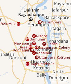 |
| Cities and towns in the Sreerampur Uttarpara CD Block in Srirampore subdivision in Hooghly district M: municipal city/ town, CT: census town, Owing to space constraints in the small map, the actual locations in a larger map may vary slightly |
Location
Dakshin Rajyadharpur is located at 22.76°N 88.32°E.[3][2]
Belumilki and Dakshin Rajyadharpur are close to Serampore.[2]
The area consists of flat alluvial plains, that form a part of the Gangetic Delta. This belt is highly industrialised.[4]
Urbanisation
Srirampore subdivision is the most urbanized of the subdivisions in Hooghly district. 73.13% of the population in the subdivision is urban and 26.88% is rural. The subdivision has 6 municipalities and 34 census towns. The municipalities are: Uttarpara Kotrung Municipality, Konnagar Municipality, Serampore Municipality, Baidyabati Municipality, Rishra Municipality and Dankuni Municipality. Amongst the CD Blocks in the subdivision, Uttarapara Serampore (census towns shown in the map alongside) had 76% urban population, Chanditala I 42%, Chanditala II 69% and Jangipara 7% (census towns in the last 3 CD Blocks are shown in a separate map).[5][6]All places marked in the map are linked in the larger full screen map.
Demographics
As per 2011 Census of India Dakshin Rajyadharpur had a total population of 11,254 of which 5,739 (51%) were males and 5,515 (49%) were females. Population below 6 years was 984. The total number of literates in Dakshin Rajyadharpur was 9,110 (88.71 % of the population over 6 years).[6]
The following Municipalities and Census Towns in Hooghly district were part of Kolkata Urban Agglomeration in 2011 census: Bansberia (M), Hugli-Chinsurah (M), Bara Khejuria (Out Growth), Shankhanagar (CT), Amodghata (CT), Chak Bansberia (CT), Naldanga (CT), Kodalia (CT), Kulihanda (CT), Simla (CT), Dharmapur (CT), Bhadreswar (M), Champdani (M), Chandannagar (M Corp.), Baidyabati (M), Serampore (M), Rishra (M), Rishra (CT), Bamunari (CT), Dakshin Rajyadharpur (CT), Nabagram Colony (CT), Konnagar (M), Uttarpara Kotrung (M), Raghunathpur (PS-Dankuni) (CT), Kanaipur (CT) and Keota (CT).[7]
As of 2001 India census,[8] Dakshin Rajyadharpur had a population of 9303. Males constitute 52% of the population and females 48%. Dakshin Rajyadharpur has an average literacy rate of 77%, higher than the national average of 59.5%: male literacy is 81% and, female literacy is 72%. In Dakshin Rajyadharpur, 10% of the population is under 6 years of age.
Economy
Hooghly Alloy & Steels Co. Pvt. Ltd. was established in 1985 and have a 60,000 tonnes per annum rolling mills at Dakshin Rajyadharpur.[9]
Healthcare
Rajyadharpur has a Primary Health Centre with 10 beds.[10][11]
Transport
State Highway 6/ Grand Trunk Road (G.T. Road) passes through Dakshin Rajyadharpur. It is also extended upto State Highway 13 in the west.[12]
Private Bus
Train
Serampore railway station on the Howrah-Bardhaman main line is the nearest railway station.[13] It is part of the Kolkata Suburban Railway system.
References
- District-wise list of statutory towns Archived 21 July 2011 at the Wayback Machine
- "Census of India 2011, West Bengal: District Census Handbook, Hooghly" (PDF). Map of Serampur-Uttarpara CD Block, page 635. Directorate of Census Operations, West Bengal. Retrieved 26 September 2018.
- "Yahoo maps location of Dakshin Rajyadharpur". Yahoo maps. Retrieved 4 January 2009.
- "District Census Handbook: Hugli, Series-20, Part XIIA" (PDF). Physiography, Page 17-24. Directorate of Census Operations, West Bengal, 2011. Retrieved 28 September 2018.
- "District Statistical Handbook 2014 Hooghly". Table 2.2, 2.4(a). Department of Statistics and Programme Implementation, Government of West Bengal. Retrieved 3 October 2018.
- "C.D. Block Wise Primary Census Abstract Data(PCA)". 2011 census: West Bengal – District-wise CD Blocks. Registrar General and Census Commissioner, India. Retrieved 3 October 2018.
- "Provisional Population Totals, Census of India 2011" (PDF). Constituents of Urban Agglomeration Having Population Above 1 Lakh. Census of India 2011. Retrieved 16 June 2016.
- "Census of India 2001: Data from the 2001 Census, including cities, villages and towns (Provisional)". Census Commission of India. Archived from the original on 16 June 2004. Retrieved 1 November 2008.
- "Hooghly Alloy & Steels Co. Pvt. Ltd". HASCO. Retrieved 26 June 2017.
- "Health & Family Welfare Department". Health Statistics. Government of West Bengal. Retrieved 4 October 2018.
- "Hooghly.gov.phc".
- "List of State Highways in West Bengal". West Bengal Traffic Police. Retrieved 15 October 2016.
- "37815 Howrah Bardhaman Jn Local". Time Table. indiarailinfo. Retrieved 13 June 2017.
Cities, towns and locations in Hooghly District | |||||||||
|---|---|---|---|---|---|---|---|---|---|
| Cities, municipal and census towns |
| ||||||||
| Locations other than cities and towns |
| ||||||||
| Neighbourhoods | |||||||||
| Related topics |
| ||||||||