Uttarpara
Uttarpara or Uttarpara Kotrung is a city and a municipality of Hooghly district in the Indian state of West Bengal. It is a part of the area covered by Kolkata Metropolitan Development Authority (KMDA).[4] Uttarpara is located at 22.67°N 88.35°E, within 10 km from Kolkata, the capital of the state of West Bengal. It is located along the Ganges river, across from the Dakshineswar Kali Temple. Uttarpara is home to the Uttarpara Jayakrishna Public Library, Asia's oldest free public library.

Uttarpara Uttarpara Kotrung | |
|---|---|
City | |
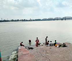 College Ghat, Uttarpara | |
 Uttarpara Location in West Bengal, India  Uttarpara Uttarpara (India) | |
| Coordinates: 22.67°N 88.35°E | |
| Country | |
| State | West Bengal |
| District | Hooghly |
| Region | Greater Kolkata |
| Established | 1853 |
| Government | |
| • Type | Municipality |
| • Body | Uttarpara Kotrung Municipality |
| • Municipality Chairperson | Dilip Yadav (AITC) [1] |
| Area | |
| • Total | 11.75 km2 (4.54 sq mi) |
| Population (2011) | |
| • Total | 159,147 |
| • Density | 14,000/km2 (35,000/sq mi) |
| Languages | |
| • Official | Bengali[2][3] |
| • Additional official | English[3] |
| Time zone | UTC+5:30 (IST) |
| PIN | 712258 |
| Telephone code | +91 33 |
| Vehicle registration | WB |
| Lok Sabha constituency | Serampore |
| Vidhan Sabha constituency | Uttarpara |
| Website | www |
Geography
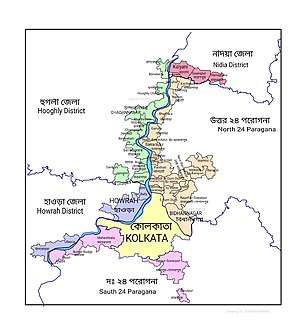
 |
| Cities and towns in the Sreerampur Uttarpara CD Block in Srirampore subdivision in Hooghly district M: municipal city/ town, CT: census town, Owing to space constraints in the small map, the actual locations in a larger map may vary slightly |
Uttarpara is at the southernmost part of Hooghly district. It is separated from Bally, Howrah by Bally Canal (Bally Khal). The old name of Uttarpara was "North Bally". A bridge was constructed in 1846 over Bally Canal to connect Uttarpara with Bally.[5]
Demographics
As per 2011 Census of India Uttarpara had a total population of 159,147 of which 81,410 (51%) were males and 77,737 (49%) were females. Population below 6 years was 11,760. The total number of literates in Uttarpara Kotrung was 133,610 (90.65% of the population over 6 years).[6]
As of 2001 India census,[7] Uttarpara Kotrung had a population of 150,204. Males constitute 52% of the population and females 48%. Uttarpara Kotrung has an average literacy rate of 79%, higher than the national average of 59.5%: male literacy is 82% and female literacy is 76%. In Uttarpara Kotrung, 8% of the population is under 6 years of age.
Kolkata Urban Agglomeration
The following Municipalities and Census Towns in Hooghly district were part of Kolkata Urban Agglomeration in 2011 census: Bansberia (M), Hugli-Chinsurah (M), Bara Khejuria (Out Growth), Shankhanagar (CT), Amodghata (CT), Chak Bansberia (CT), Naldanga (CT), Kodalia (CT), Kulihanda (CT), Simla (CT), Dharmapur (CT), Bhadreswar (M), Champdani (M), Chandannagar (M Corp.), Baidyabati (M), Serampore (M), Rishra (M), Rishra (CT), Bamunari (CT), Dakshin Rajyadharpur (CT), Nabagram Colony (CT), Konnagar (M), Uttarpara Kotrung (M), Raghunathpur (PS-Dankuni) (M), Kanaipur (CT) and Keota (CT).[8]
Economy
Hindustan Motors
Uttarpara was home to India's first car factory, Hindustan Motors, which produced the legendary Ambassador cars.[9] The plant was closed in 2014 when production of the Ambassador was scrapped.
Transport
State Highway 6/ Grand Trunk Road (G.T. Road) passes through Uttarpara.[10]
Private Bus
- 2 Chunchura Court - Dakshineswar
- 285 Serampore - Salt Lake Sector-5
Train
Uttarpara railway station is situated in the Howrah-Bardhaman main line.[11] It is part of the Kolkata Suburban Railway system.
Culture
Uttarpara boasts of a rich cultural heritage. The town once boasted of sylvan peace, beautiful buildings, epitome of great architectural works and steeped in cultural heritage. Bengali poet Michael Madhusudan Dutt spent his last days in Uttarpara Joykrishna Library.[12]
Education
High school
- Uttarpara Govt. High School
- Uttarpara Amarendra Vidyapith
- Bhadrakali High School
- Dreamland School
- Hindmotor High School
- Uttarpara Girls' High School
Police
Uttarpara police station has jurisdiction over Uttarpa-Kotrung and Konnagar Municipal areas and parts of Sreerampur Uttarpara CD Block.[13][14] The police station is under Chandannagar Police Commissionerate.
Notable people
- Pramoda Charan Banerji, judge in the Allahabad High Court
- Amarendra Chatterjee, freedom fighter
- Malay Roy Choudhury, founder of Hungry generation Movement
- Samir Roychoudhury member of Krittibas group and co-founder of the "Hungryalist" movement
- Manilal Nag Sitarist
- Pritam Kotal Footballer (India, Mohun Bagan A.C., Delhi Dynamos FC)
- Babul Supriyo Present Union Minister of State for Environment, Forest and Climate Change, Member of Parliament for Asansol, singer.
See also
References
- "Trinamul set to keep Uttarpara". The Telegraph. Calcutta. 18 June 2005. Retrieved 1 November 2018.
- "52nd REPORT OF THE COMMISSIONER FOR LINGUISTIC MINORITIES IN INDIA" (PDF). Nclm.nic.in. Ministry of Minority Affairs. p. 85. Archived from the original (PDF) on 25 May 2017. Retrieved 29 August 2019.
- "Fact and Figures". Wb.gov.in. Retrieved 29 August 2019.
- "Base Map of Kolkata metropolitan area". Kolkata Metropolitan Development Authority. Archived from the original on 7 March 2007. Retrieved 3 September 2007.
- "Importance of Bally Khal".
- "2011 Census – Primary Census Abstract Data Tables". West Bengal – District-wise. Registrar General and Census Commissioner, India. Retrieved 15 June 2016.
- "Census of India 2001: Data from the 2001 Census, including cities, villages and towns (Provisional)". Census Commission of India. Archived from the original on 16 June 2004. Retrieved 1 November 2008.
- "Provisional Population Totals, Census of India 2011" (PDF). Constituents of Urban Agglomeration Having Population Above 1 Lakh. Census of India 2011. Retrieved 16 June 2016.
- Hindustan Motors website Archived 3 April 2005 at the Wayback Machine
- "List of State Highways in West Bengal". West Bengal Traffic Police. Retrieved 15 October 2016.
- "37815 Howrah Bardhaman Jn Local". Time Table. indiarailinfo. Retrieved 13 June 2017.
- "Uttarpara - History, Sociology, Culture and lots more". Retrieved 18 October 2016.
- "District Statistical Handbook 2014 Hooghly". Tables 2.1, 2.2. Department of Statistics and Programme Implementation, Government of West Bengal. Retrieved 15 October 2018.
- "Hooghly District Police". West Bengal Police. Retrieved 20 June 2017.
External links
| Kolkata Municipal Corporation |
|
|---|---|
| Kolkata Urban Agglomeration Outside KMC |
|
| |