Barasat
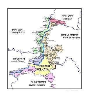
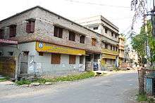
Barasat is a city (/ˈbɑːrəˌsʌt/) and Municipality in North 24 Parganas. It is also the district headquarters of the district North 24 Parganas. It is close to Kolkata and also a part of the area covered by Kolkata Metropolitan Development Authority (KMDA). The city is an important railway and roadway junction. Barasat is also the name of a sub-division centering the city. It is also a regional transportation hub as a rail and road junction. NH 12 (formerly NH 34/ Krishnanagar Road towards North Bengal), NH 112 (formerly NH 35/ Jessore Road, leading to the Bangladesh border at Petrapole), Taki Road and Barrackpore-Barasat Road (both are part of SH 2) are the main connectivity links to the city.
Barasat বারাসাত | |
|---|---|
City | |
 | |
 Barasat Location in West Bengal, India  Barasat Barasat (India) | |
| Coordinates: 22.72°N 88.48°E | |
| Country | |
| State | West Bengal |
| District | North 24 parganas |
| Region | Greater Kolkata |
| Government | |
| • Type | Municipality |
| • Body | Barasat Municipality[1] |
| • Chairman | Sunil Mukherjee[2] |
| • MP | Kakali Ghosh Dastidar |
| • MLA | Chiranjeet Chakraborty |
| Area | |
| • Total | 34.06 km2 (13.15 sq mi) |
| Elevation | 4 m (13 ft) |
| Population (2011) | |
| • Total | 278,235 |
| • Density | 8,200/km2 (21,000/sq mi) |
| Languages | |
| • Official | Bengali, English |
| Time zone | UTC+5:30 (IST) |
| PIN | 700124, 700125, 700126, 700127 |
| Telephone code | +91 33(033) |
| Vehicle registration | WB 25, WB 26 |
| Lok Sabha constituency | Barasat |
| Vidhan Sabha constituency | Barasat |
| Website | north24parganas |

History

During the Mogul period, Sankar Chakraborty (a commander of the zamindar Pratapaditya and king of Jessore in present-day Bangladesh) came to Barasat, Kolkata in 1600 and established himself. In 1700, Hazarat Ekdil Shah moved to the town and was known as a social reformer. His tomb, in Kazipara, is a pilgrimage site for the Muslim community. Pratapaditya made his way to Kolkata from Jessore; Sirajudullah went to Kolkata from Murshidabad via Barasat on a road which became two national highways.
Under the British Raj, East India Company officials from Calcutta (Kolkata) made Barasat a weekend retreat and built houses with gardens. Warren Hastings built his villa in the heart of Barasat and Bankim Chandra Chatterjee was the town's first Indian deputy magistrate.
Indigo cultivation was a major industry and indigo merchants were known for their inhumane treatment of farmers. Titumir, a farmer, fomented a revolution against indigo merchants in Barasat. Iswar Chandra Vidyasagar, Pyari Charan Sarkar and Kalikrishna Mitra were known for social reformation in the town, including women's education and widow remarriage. During the early nineteenth century, Barasat Cadet College trained new recruits and cadets from Europe; the college closed in 1811.[3][4]
From 1834 to 1861, Barasat was the seat of Barasat District. The district became a subdivision of the Twenty-four Parganas district in 1861,[3] and Barasat is the headquarters of North 24 Parganas district.[5]
Geography and climate
Barasat is located in eastern India's Ganges Delta. The Bangladesh border, at Petrapole, is 70–80 kilometres (43–50 mi) from the city.
Its average elevation is 11 metres (36 ft). The nearest river is the Ganges, about 15 kilometres (9.3 mi) to the west, and it is on the Gangetic plain.
Barasat has a tropical climate similar to the rest West Bengal. The region experiences a monsoon from early June to mid-September. The climate is dry in winter (mid-November to mid-February) and humid in summer.
Climate data for Kolkata (Alipore) 1981–2010, extremes 1901–2012 | |||||||||||||
|---|---|---|---|---|---|---|---|---|---|---|---|---|---|
| Month | Jan | Feb | Mar | Apr | May | Jun | Jul | Aug | Sep | Oct | Nov | Dec | Year |
| Record high °C (°F) | 32.8 (91.0) |
38.4 (101.1) |
41.1 (106.0) |
43.3 (109.9) |
43.7 (110.7) |
43.9 (111.0) |
39.9 (103.8) |
38.4 (101.1) |
38.9 (102.0) |
39.0 (102.2) |
34.9 (94.8) |
32.5 (90.5) |
43.9 (111.0) |
| Mean maximum °C (°F) | 29.8 (85.6) |
33.5 (92.3) |
37.4 (99.3) |
38.5 (101.3) |
38.8 (101.8) |
38.0 (100.4) |
35.9 (96.6) |
35.0 (95.0) |
35.3 (95.5) |
35.1 (95.2) |
32.9 (91.2) |
29.8 (85.6) |
39.8 (103.6) |
| Average high °C (°F) | 25.8 (78.4) |
29.2 (84.6) |
33.5 (92.3) |
35.3 (95.5) |
35.3 (95.5) |
33.8 (92.8) |
32.4 (90.3) |
32.2 (90.0) |
32.4 (90.3) |
32.2 (90.0) |
30.1 (86.2) |
27.0 (80.6) |
31.6 (88.9) |
| Daily mean °C (°F) | 20.0 (68.0) |
23.6 (74.5) |
28.0 (82.4) |
30.4 (86.7) |
30.9 (87.6) |
30.4 (86.7) |
29.4 (84.9) |
29.3 (84.7) |
29.2 (84.6) |
28.1 (82.6) |
25.0 (77.0) |
21.2 (70.2) |
27.1 (80.8) |
| Average low °C (°F) | 14.1 (57.4) |
17.8 (64.0) |
22.4 (72.3) |
25.3 (77.5) |
26.4 (79.5) |
26.8 (80.2) |
26.5 (79.7) |
26.4 (79.5) |
26.0 (78.8) |
24.1 (75.4) |
19.7 (67.5) |
15.2 (59.4) |
22.6 (72.7) |
| Mean minimum °C (°F) | 10.7 (51.3) |
12.9 (55.2) |
17.6 (63.7) |
20.4 (68.7) |
21.5 (70.7) |
23.7 (74.7) |
24.3 (75.7) |
24.4 (75.9) |
23.8 (74.8) |
20.6 (69.1) |
15.4 (59.7) |
11.8 (53.2) |
10.4 (50.7) |
| Record low °C (°F) | 6.7 (44.1) |
7.2 (45.0) |
10.0 (50.0) |
16.1 (61.0) |
17.9 (64.2) |
20.4 (68.7) |
20.6 (69.1) |
22.6 (72.7) |
20.6 (69.1) |
17.2 (63.0) |
10.6 (51.1) |
7.2 (45.0) |
6.7 (44.1) |
| Average rainfall mm (inches) | 10.4 (0.41) |
20.9 (0.82) |
35.2 (1.39) |
58.9 (2.32) |
133.1 (5.24) |
300.6 (11.83) |
396.0 (15.59) |
344.5 (13.56) |
318.1 (12.52) |
180.5 (7.11) |
35.1 (1.38) |
3.2 (0.13) |
1,836.5 (72.30) |
| Average rainy days | 1.1 | 1.7 | 2.2 | 3.4 | 7.0 | 12.8 | 17.7 | 16.9 | 13.9 | 7.4 | 1.3 | 0.5 | 85.9 |
| Average relative humidity (%) (at 17:30 IST) | 61 | 54 | 51 | 62 | 68 | 77 | 82 | 83 | 82 | 75 | 67 | 65 | 69 |
| Mean monthly sunshine hours | 213.9 | 211.9 | 229.4 | 240.0 | 232.5 | 135.0 | 105.4 | 117.8 | 126.0 | 201.5 | 216.0 | 204.6 | 2,234 |
| Mean daily sunshine hours | 6.9 | 7.5 | 7.4 | 8.0 | 7.5 | 4.5 | 3.4 | 3.8 | 4.2 | 6.5 | 7.2 | 6.6 | 6.1 |
| Source 1: India Meteorological Department (sun 1971–2000)[6][7][8] | |||||||||||||
| Source 2: Tokyo Climate Center (mean temperatures 1981–2010)[9] | |||||||||||||
Demographics
According to the 2011 Indian census, Barasat had a total population of 278,235; 140,882 (51%) were males and 137,613 (49%) females, and 22,605 were under age six. The literacy rate was 89.69 percent of the population over age six (229,279 people).[10] The town's population increased from 237,783 in 2001. The literacy rate that year was 77 percent, higher than the national average of 59.5 percent. Of the literate population, 54 percent were male and 46 percent female.[11] Barasat was part of the Kolkata Urban Agglomeration in the 2011 census.[12]
Economy
Cotton weaving is Barasat's major industry, and the town is a trade centre for rice, legumes, sugarcane, potatoes, and coconuts.[13] Now it is becoming a shopping destination with various malls including all major brands and multiplexes.
About 32,00,000 people commute daily from around the city to Barasat. Fifty-eight trains transport commuters from 24 stations in the town's Sealdah-Bangaon section and 32 trains carry commuters from 30 stations in the Seadah-Hasnabad section.[14]
Administration
Although Barasat Municipality was established on 1 April 1869, it had no independent existence until 1882. It was controlled by the magistrate office (and its magistrate), without a chairman. In 1882, Barasat Municipality was formed and a local government was created. Barasat Association, a citizen organization, donated land for the construction of municipal buildings.
Barasat is divided into 29 mouzas. There were originally four wards, later increasing to 18. After surrounding panchayats were incorporated in 1995, the number of wards increased to 32. In 2015, before the municipal election, the number of wards increased to 35.[5] Barasat is part of the Kolkata Metropolitan Area, for which the KMDA is the statutory planning and development authority.[15] The KMDA manages the area's infrastructure development.[16]
The district court handles local and national cases. The Barasat police have a jurisdiction of 4.6 square kilometres (1.8 sq mi), and serves a population of 417,663 in the Barasat municipal area. There are two police outposts (in Barasat and Badu), and a women's police station in the town.[17]
Zilla Parishad (district council)
The Zilla Parishad of North 24 Parganas was founded on 26 June 1986, with the north–south bifurcation of the 24 Parganas district. The highest tier of the three-tier panchayati raj system, its headquarters are at Barasat. It has six riverine panchayat samitis in the Sundarbans, which has a saline tract on one side and rich alluvial tracts of the Ichamati River basin and industrial belt of Barrackpore on the other side. Its territory extends on the east to the Bangladesh border.[18]
Transport
Road


Barasat is connected by road to Kolkata, North Bengal, Bangladesh and other cities of West Bengal; many of the routes originate from the bus terminal.
Barasat is a road junction. NH 12 (formerly Krishnanagar Road) runs to North Bengal and is the major link between Kolkata and North-East India. Jessore Road (NH 112) leads to Bongaon and the Bangladesh border at Petrapole. Taki Road (part of SH 2) leads to Basirhat, Hasnabad and Taki via Berachampa. Barrackpore-Barasat Road (part of SH 2) links NH 112 at Barasat with Kalyani Expressway and Barrackpore.
Crossroads include:
- Champadali More – a town centre, where the NH 35 (old) is divided by Jessore Road and Basirhat Road. Several bus routes are available there.
- Colony More – the junction of Barrackpore Highway and Krishna Nagar Highway, connected to Kolkata.
- Duck Banglow More — the junction of Jessore Road and Krishnanagar Highway.
Rail
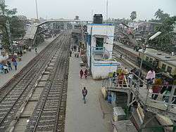
The town is connected by rail to Sealdah, Bongaon and Basirhat. Barasat is 22 km from the Sealdah railway station on the Sealdah–Bangaon branch line, and is at one end of the Barasat-Basirhat-Hasnabad branch line of the Eastern Railway zone.[19]
Barasat Junction is the town's main rail station, on the Bongaon line (North Section). This junction is where the Bongaon and Hasnabad-Basirhat lines of Kolkata Suburban Railway separate. The Barasat–Basirhat Railway, originally operated by Martin's Light Railways, is a section (BT-HNB) of the Sealdah division of Eastern Railway. The town has two other rail stations: Hridaypur (on the Sealdah-Bongaon line) and Kazipara (on the Barasat-Hasnabad line).
Air
Barasat is served by Netaji Subhas Chandra Bose International Airport, about 11 km away, with domestic and international terminals.
Culture
Barasat's culture is characteristic of small towns in Bengal. The middle class participates in the Bengali cultural traditions of drama, recitation, classical music, songs and dances; young people publish little magazines and run social programs, such as health check-up camps.
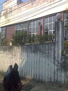
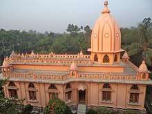
The town has religious ashrams, such as Pranabananda, Prabhu Jagadbandhu, Shibananda Dham, Shankar Moth O Mission, Sree Sree Yogashram and Hazarat Ekdil Shah Darga. There are several Christian churches in Barasat, including the Assemblies of God church on the NH34.
Events and activities are organized throughout the year. Cultural diversity has increased, with people coming from elsewhere in India and Bangladesh. Rabindra Bhavan is a cultural building erected by the West Bengal State Cultural Department on Jessore Road. Muslims and Hindus have attended an annual fair held in honor of a Muslim saint, Hazrat Ekdil Shah, for centuries. Clubs organize another event, Kali Puja, in which the community joins.
Education
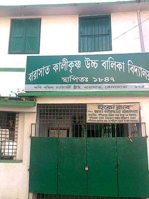
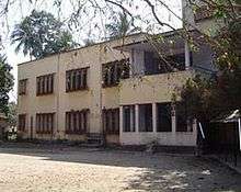
Barasat's schools are run by the state government or private organizations. The schools primarily use English or Bengali as the medium of instruction. They are affiliated with the Council for the Indian School Certificate Examinations (CISCE), the Central Board for Secondary Education (CBSE), or the West Bengal Board of Secondary Education. Under the 10+2+3 plan, after completing their secondary education students typically enroll in a school with a higher secondary facility affiliated with West Bengal Council of Higher Secondary Education, CISCE or CBSE. Students usually choose from one of three streams (liberal arts, commerce or science), although vocational streams are also available. Upon completing the required coursework, students may enroll in a general- or professional-degree programme. The town's secondary-education system includes Barasat Peary Charan Sarkar Government High School, Barasat Mahatma Gandhi Memorial High School, Banamalipur Priyanath Institution (HS), Nabapally Boys' High School, Kalikrishna Girls' High School, The Central Modern School, Barasat Satya Bharati Vidya Pith, Auxilium Convent School , Aditya Academy (Secondary) and Barasat Indira Gandhi Memorial High School. Barasat Binapani High School.
Colleges and universities
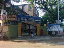
- Barasat Government College
- Barasat College, previously Barasat Evening College
- RKVM Sarada Maa Girls' College, Barasat's first women's college
- Brainware University, an engineering and management college affiliated with the West Bengal University of Technology and accredited by the AICTE
- Adamas Institute of Technology[Defunct], an engineering college affiliated with the WBUT and approved by the AICTE
- Camellia School Of Engineering and Technology, an engineering college affiliated with the WBUT
- Kingston Educational Institute, a polytechnic, law, management and science college affiliated with the WBUT
- West Bengal State University, created from the University of Calcutta in 2008. All North 24 Parganas colleges formerly affiliated with the University of Calcutta are affiliated with WBSU
- Adamas University, founded in 2014 with schools of engineering and technology, science, social science, law and justice, economics and commerce, management, biotechnology and pharmaceutical technology
Sports
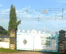
Barasat Stadium or Vidyasagar Krirangan hosts Calcutta Football League matches and district, state and occasional national-level volleyball and football tournaments. The Barasat Sub-Division Sports Association, founded in 1940, has 24 fully affiliated and 15 sectionally affiliated clubs. Residents play football, cricket and traditional Indian sports such as kabbadi and kho-kho.
Healthcare
The North 24 Parganas District Hospital (Barasat State General Hospital) is the town's major healthcare facility. Barasat Cancer Research and Welfare Center is a treatment and research facility and the town has several privately operated nursing homes and hospitals.
Notable residents
| Wikisource has original text related to this article: |
Bankim Chandra Chattopadhyay was the deputy magistrate of 24 Parganas during the 19th century. Graves Haughton became a cadet in 1808, and received his first commission on 13 March 1810 from Barasat cadet institution. Haughton was fluent in Indian (Hindustani) languages, and received the sword of merit and a monetary award from the Barasat institution. He studied regional languages at the College of Fort William in Calcutta, receiving seven medals, three degrees of honor and monetary awards for proficiency in Arabic, Persian, Hindustani (Hindi), Sanskrit and Bengali. Haughton was a lieutenant, a noted orientalist, a Knight of The Royal Guelphic Order, a member of the Asiatic Society and a published author.[20][21]
References
- "Barasat Municipality".
- Official District Administration site Archived 15 January 2007 at the Wayback Machine
- Hunter, William Wilson (1885). The Imperial Gazetteer of India. Trübner & co. p. 123.
- Wheeler, Mortimer (1935). The Cambridge History of India. Cambridge University Press (CUP). p. 161.
- "Barasat" (PDF). jnnurmwestbengal.gov.in. Archived from the original (PDF) on 2 April 2012. Retrieved 5 September 2011.
- "Station: Calcutta (Alipur) Climatological Table 1981–2010" (PDF). Climatological Normals 1981–2010. India Meteorological Department. January 2015. pp. 161–162. Archived from the original (PDF) on 5 February 2020. Retrieved 2 March 2020.
- "Extremes of Temperature & Rainfall for Indian Stations (Up to 2012)" (PDF). India Meteorological Department. December 2016. p. M237. Archived from the original (PDF) on 5 February 2020. Retrieved 2 March 2020.
- "Table 3 Monthly mean duration of Sun Shine (hours) at different locations in India" (PDF). Daily Normals of Global & Diffuse Radiation (1971–2000). India Meteorological Department. December 2016. p. M-3. Archived from the original (PDF) on 5 February 2020. Retrieved 2 March 2020.
- "Normals Data: Kolkata/Alipore - India Latitude: 22.53°N Longitude: 88.33°E Height: 6 (m)". Japan Meteorological Agency. Archived from the original on 2 March 2020. Retrieved 2 March 2020.
- "2011 Census – Primary Census Abstract Data Tables". West Bengal – District-wise. Registrar General and Census Commissioner, India. Retrieved 29 May 2018.
- "Census of India 2001: Data from the 2001 Census, including cities, villages and towns (Provisional)". Census Commission of India. Archived from the original on 16 June 2004. Retrieved 1 November 2008.
- "Provisional Population Totals, Census of India 2011" (PDF). Constituents of Urban Agglomeration Having Population Above 1 Lakh. Census of India 2011. Retrieved 30 May 2018.
- "Barasat | India". Encyclopædia Britannica. Retrieved 23 November 2017.
- Dey, Teesta. "The Suburban Railway Network of Kolkata: A Geographical Apprisal" (PDF). eTraverse, the Indian journal of spatial science, 2012. Archived from the original (PDF) on 18 November 2017. Retrieved 3 June 2018.
- "Kolkata Metropolitan Development Authoity, Annual Report 2010-11". 1/1 Kolkata Metropolitan Area Map. KMDA. Retrieved 4 June 2018.
- "Kolkata Metropolitan Development Authority, Annual Report 2010-11". 1 / 2 Role of KMDA. KMDA. Retrieved 4 June 2018.
- "North 24 Parganas Dist. Police". Know Your Police Station. District Police. Retrieved 4 June 2018.
- "Barasat Zilla Parishad". north24parganas.gov.in. Archived from the original on 3 October 2011. Retrieved 21 September 2011.
- Eastern Railway timetable.
- Dictionary of National Biography
- http://odnb2.ifactory.com/view/article/12611%5B%5D
External links
| Wikisource has the text of the 1911 Encyclopædia Britannica article Barasat. |

- Census 2001 data
North 24 Parganas district topics | |||||||||
|---|---|---|---|---|---|---|---|---|---|
| General |
| ||||||||
| Subdivisions | |||||||||
| Municipalities | |||||||||
| Community development blocks |
| ||||||||
| Rivers | |||||||||
| Transport |
| ||||||||
| Railway stations |
| ||||||||
| Institutes of higher learning |
| ||||||||
| Lok Sabha constituencies | |||||||||
| Vidhan Sabha constituencies |
| ||||||||
| Former Vidhan Sabha constituencies | |||||||||
| See also |
| ||||||||