Madhyamgram
Madhyamgram is a city and a municipality in North 24 Parganas district of the Indian state of West Bengal.[2] It is close to Kolkata and also a part of the area covered by Kolkata Metropolitan Development Authority (KMDA).[5]

Madhyamgram | |
|---|---|
City | |
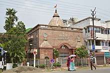
 Madhyamgram Chowmatha on Jessore Road | |
 Madhyamgram Location in West Bengal, India  Madhyamgram Madhyamgram (India) | |
| Coordinates: 22.70°N 88.45°E | |
| Country | |
| State | West Bengal |
| District | North 24 Parganas |
| Region | Greater Kolkata |
| Government | |
| • Type | Municipality |
| • Body | Madhyamgram Municipality |
| • Chairman | Rathin Ghosh[1] |
| Elevation | 15 m (49 ft) |
| Population (2011)[2] | |
| • Total | 196,127 |
| Languages | |
| • Official | Bengali[3][4] |
| • Additional official | English[3] |
| Time zone | UTC+5:30 (IST) |
| PIN | 700127, 700128, 700129, 700130,700155 |
| Telephone code | +91 33 |
| Vehicle registration | WB |
| Lok Sabha constituency | Barasat |
| Vidhan Sabha constituency | Madhyamgram |
History
Madhyamgram was one of the twelve feudal provinces of Bengal. It was under Pratapaditya Roy, ruler of Jessore during the Mughal Empire.
On 21[[]] December 1757 Mir Jafar, the Nawab of Bengal, presented twenty-four parganas to the East India Company as dowry which also included Madhyamgram, under Anwarpur Pargana, adjacent to Barasat.
The first railway line from Madhyamgram to Duttapukur was commissioned in 1882 and the station was called Chandipur. Madhyamgram was then named as Majher Gaon, probably because the area was situated between Badu (Chakradharpur Mouza) and Sajirhat (Guchuria Mouza).
The present narrow Noai Canal, now acting as a dividing border line between New Barrackpore and Madhyamgram, stretching from the South of Ganganagar to Sajirhat in the West used to be a wide river, once called Labanyabati, which through colloquial transformation became the Noai River, and after years of silt depositions, turned into Noai Canal.
At that time, Anwarpur Pargana was famous for its tobacco trade and a special sweet-smelling blended tobacco was manufactured in Madhyamgram.
Madhyamgram was also a big paddy growing area, and the Labanya River was a medium of navigation for the exportation of those products. Madhyamgram was also famous for its fine embroidery works that attracted appreciation from Delhi and Mumbai. Many Muslim families maintained a livelihood through those works.
Geography
Location
Madhyamgram is bounded by Barasat II in the east; Barasat II, Rajarhat (community development block), Bidhannagar Municipal Corporation and North Dum Dum in the south; New Barrackpore and Barrackpore II in the west and Barasat in the north.
Police station
Madhyamgram police station serves a population of 198,964. It has jurisdiction over Madhyamgram Municipal area and Barasat II CD Block.[6]
Climate
The climate is tropical, like the rest of the Gangetic West Bengal. The hallmark season is the Monsoon—which occurs from early June to mid September. The weather remains dry during the winter (mid-November to mid-February) and humid during summer.
Temperature: 41 °C in May (max) and 8.3 °C in January (min).
Demographics
Population
As per the 2011 Census of India, Madhyamgram had a total population of 196,127, of which 98,864 were males and 97,263 were females. Population in the age group of 0 to 6 years was 16,351. The total number of literates in Madhyamgram was 161,087. The effective literacy (7+) of population over 6 years of age was 89.60%. The Scheduled Castes and Scheduled Tribes population was 24,822 and 2,842 respectively. Madhyamgram had a total of 48942 households as of 2011.[2]
As of the 2001 Indian census,[7] Madhyamgram had a population of 198,964. Males constitute 51% of the population and females 49%. Madhyamgram has an average literacy rate of 76%, higher than the national average of 59.5%: male literacy is 80% and female literacy is 71%. In Madhyamgram, 10% of the population is under 6 years of age.
Kolkata Urban Agglomeration
The following Municipalities and Census Town in Barasat Sadar subdivision were part of Kolkata Urban Agglomeration in the 2011 census: Barasat (M), Madhyamgram (M), Rajarhat-Gopalpur (M) (merged with Bidhannagar Municipal Corporation in 2015) and Raigachhi (CT).[8]
Economy
There is a major textile mill and a rubber factory in this area. Famous Shopping Complex-cum-Multiplex Star Mall is also located here on Jessore Road. The mall was launched in 2008 and has a gross leasable area of 237,000 sqft.[9][10]
Transport

Madhyamgram is characterised by its close proximity to an airport (Kolkata Airport) (around 15 minutes). Madhyamgram is a famous 4-Point junction of Jessore Road (part of State Highway 12), Sodepur-Barasat Road and Badu Road.[11] East and west parts of Madhyamgram are connected with a Rail Overbridge (Madhyamgram Bridge), which was opened in 2006.[12]
Many private and governmental public buses serve the town. Taxi services are one of the most popular forms of transportion to reach nearby towns like Sodepur, New Barrackpore and Barasat. Rickshaws, three-wheeled pedalled vans and battery-operated e-rickshaws ("toto" vans) are also used for short distances.
Madhyamgram railway station on the Sealdah–Hasnabad–Bangaon–Ranaghat line serves the town.
Education
Vivekananda College is a degree college in Madhyamgram. The engineering college Camellia Institute of Technology and the management college Camellia School Of Business Management are also located here. It also has number of secondary and higher secondary schools.
Sports
Madhyamgram High School has won the Subroto Cup, an all-India inter-school soccer competition, seven times, which includes a hat-trick (in the years 1981, 1982 and 1983).[13]
References
- Official District Administration site Archived 15 January 2007 at the Wayback Machine
- "Census of India: Madhyamgram". www.censusindia.gov.in. Retrieved 16 October 2019.
- "Fact and Figures". Wb.gov.in. Retrieved 16 October 2019.
- "52nd REPORT OF THE COMMISSIONER FOR LINGUISTIC MINORITIES IN INDIA" (PDF). Nclm.nic.in. Ministry of Minority Affairs. p. 85. Archived from the original (PDF) on 25 May 2017. Retrieved 16 October 2019.
- District-wise list of statutory towns, Archived 19 March 2005 at the Wayback Machine
- "North 24 Parganas Dist. Police". Know Your Police Station. District Police. Retrieved 4 June 2018.
- "Census of India 2001: Data from the 2001 Census, including cities, villages and towns (Provisional)". Census Commission of India. Archived from the original on 16 June 2004. Retrieved 1 November 2008.
- "Provisional Population Totals, Census of India 2011" (PDF). Constituents of Urban Agglomeration Having Population Above 1 Lakh. Census of India 2011. Retrieved 30 May 2018.
- "Star Mall".
- "Star Mall Information".
- Google maps
- "Madhyamgram Bridge".
- Marmar Mukhopadhyay (21 July 2005). Total Quality Management in Education. SAGE Publications. p. 157. ISBN 978-0-7619-3368-7.
External links

North 24 Parganas district topics | |||||||||
|---|---|---|---|---|---|---|---|---|---|
| General |
| ||||||||
| Subdivisions | |||||||||
| Municipalities | |||||||||
| Community development blocks |
| ||||||||
| Rivers | |||||||||
| Transport |
| ||||||||
| Railway stations |
| ||||||||
| Institutes of higher learning |
| ||||||||
| Lok Sabha constituencies | |||||||||
| Vidhan Sabha constituencies |
| ||||||||
| Former Vidhan Sabha constituencies | |||||||||
| See also |
| ||||||||