Hooghly district
Hooghly district (/ˈhuːɡliː/) is one of the districts of the state of West Bengal in India. It can alternatively be spelt Hoogli or Hugli. The district is named after the Hooghly River.
Hooghly district | |
|---|---|
District of West Bengal | |
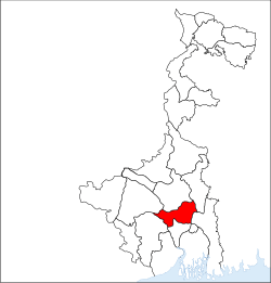 Location of Hooghly district in West Bengal | |
| Country | India |
| State | West Bengal |
| Division | Presidency |
| Headquarters | Chinsurah |
| Government | |
| • Lok Sabha constituencies | Arambagh (with 1 assembly segment in Paschim Medinipur), Hooghly, Serampore (with 2 assembly segments in Howrah district) |
| • Vidhan Sabha constituencies | Uttarpara, Sreerampur, Champdani, Singur, Chandannagar, Chunchura, Balagarh, Pandua, Saptagram, Chanditala, Jangipara, Haripal, Dhanekhali, Tarakeswar, Pursurah, Arambag, Goghat, Khanakul |
| Area | |
| • Total | 3,149 km2 (1,216 sq mi) |
| Population (2011) | |
| • Total | 5,519,145 |
| • Density | 1,800/km2 (4,500/sq mi) |
| Demographics | |
| • Literacy | 82.55% |
| • Sex ratio | 961 |
| Time zone | UTC+05:30 (IST) |
| Major highways | NH 2, NH 6, Grand Trunk Road |
| Average annual precipitation | 1,500 mm |
| Website | www |
The headquarters of the district are at Hooghly-Chinsura (Chuchura). There are four subdivisions: Chinsura Sadar, Serampore, Chandannagar, and Arambag.
History
The district of Hooghly derived its name from the town of Hooghly on the west bank of the Hooghly River about 40 km north of Kolkata. This town was a major river port for trade in India before colonialism.
The district has thousands of years of rich heritage as part of the Bengali kingdom of Bhurshut. The first European to reach this area was the Portuguese sailor Vasco da Gama. In 1536 Portuguese traders obtained a permit from Sultan Mahmud Shah to trade in this area. In those days the Hooghly River was the main route for transportation and Hooghly served as an excellent trading port.
Within a few decades, the town of Hooghly turned into a major commercial centre and the largest port in Bengal. Later in 1579–80 Emperor Akbar gave permission to a Portuguese captain Pedro Tavares to establish a city anywhere in the Bengal province. They chose Hooghly, and it became the first European settlement in Bengal. In 1599 the Portuguese traders built a convent and a church in Bandel. This is the first Christian church in Bengal known as ‘Bandel Church’ today.
The Portuguese traders started slave trading, robbery and converting natives into Christians by pressure. At one point they stopped paying taxes to the Mughal Empire. As a result, Emperor Shah Jahan ordered the then-ruler of Bengal province, Qasim Khan Juvayni, to block the city of Hooghly. This led to a war in which the Portuguese were defeated.
Among other European powers that came to Hooghly were the Dutch, the Danish, the British, the French, the Belgians and the Germans. Dutch traders centred their activities in the town Chuchura which is south of Hooghly. Chandannagar became the base of the French and the city remained under their control from 1816 to 1950. Similarly, the Danish establishment in settlement in Serampore (1755). All these towns are on the west bank of the Hooghly River and served as ports. Among these European countries, the British ultimately became most powerful.

Initially the British were based in and around the city of Hooghly like traders from other countries. In 1690 Job Charnock decided to shift the British trading centre from Hooghly-Chinsura to Calcutta. The reason behind this decision was the strategically safe location of Calcutta and its proximity to the Bay of Bengal. As a result, trade and commerce in the Bengal province shifted from the town of Hooghly to Calcutta. Hooghly lost its importance as Calcutta prospered.
After the Battle of Buxar this region was brought under direct British rule until India's independence in 1947. After independence, this district merged into the state of West Bengal.
Though the city of Hooghly is more than 500 years old, the district of Hooghly was formed in 1795 with the city of Hooghly as its headquarters. Later the headquarters shifted to the town of Chuchura. In 1843 the Howrah district was created from the southern portion of this district. And in 1872, the south-west portion of this district was merged into the Medinipur district. The last change in area occurred in 1966.
Tarakeswar Temple
The Taraknath temple, dedicated to the Hindu god Shiva worshiped as Taraknath, is a major pilgrimage spot in the town of Tarakeswar. Built in 1729, the temple is an ‘atchala’ structure of Bengal temple architecture with a ‘natmandir’ in front. Close by are the shrines of Kali and Lakshmi Narayan. Dudhpukur, a tank to the north of the Shiva temple is believed to fulfil the prayers of those taking a dip in it.
Pilgrims visit the temple throughout the year, especially on Mondays. Thousands of pilgrims visit Tarakeswar on the occasions of Shivaratri and ‘Gajan’, the former taking place in Phalgun (Feb-March) while the latter lasts for five days ending on the last day of Chaitra (mid-April). The month of Sravana (mid-July to mid-August) is seen to be auspicious for Shiva when celebrations are held on each Monday.
Gallery
 Hangseshwari temple, in Banshberia
 Antpur Radhagovindjiu Temple
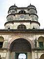 Hooghly Imambara
 Chandannagar Strand
 The back side of Imambara of Hooghly.
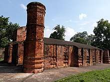 Sayed Jamaluddin Mosque in Saptagram
Geography
The district is flat, with no place having an elevation of more than 200 meters. The River Hooghly borders it to the east. Another major river is 'Damodar'.
The district is bordered by Howrah District to the south, Bardhaman District to the north, and to the east by the River Hooghly. Bankura District lies to the north-west, with Medinipur District to the south-west.

Economy
Hooghly is one of the most economically developed districts in West Bengal. It is the main jute cultivation, jute industry, and jute trade hub in the state. The jute mills are along the banks of the river Hooghly in Tribeni, Bhadreswar, Champdani and Sreerampur.
There are a number of industrial complexes including one of the largest car manufacturing plants in India, the Hindustan Motors plant in Uttarpara.
It was also home to the Singur Tata Nano controversy. Hindustan Motors plant was closed in 2014. Bandel Thermal power plant and Tribeni tissue plant (ITC) are running smoothly.
Divisions
Administrative subdivisions
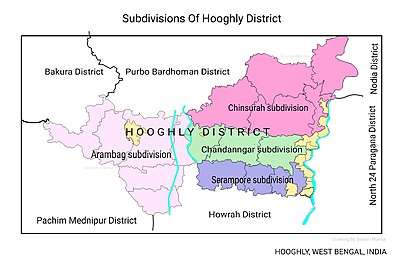
The district comprises four subdivisions: Chinsurah, Chandannagore, Srirampore and Arambagh.
- Chinsurah subdivision consists of two municipalities (Hugli-Chuchura and Bansberia) and five community development blocs: Balagarh, Chinsurah–Mogra, Dhaniakhali, Pandua and Polba–Dadpur.
- Chandannagore subdivision consists of Chandannagar municipal corporation and three municipalities (Bhadreswar, Champdani and Tarakeswar) and three community development blocs: Haripal, Singur and Tarakeswar.
- Srirampore subdivision consists of six municipalities (Serampore, Uttarpara Kotrung, Dankuni, Konnagar, Rishra and Baidyabati) and four community development blocks: Chanditala–I, Chanditala–II, Jangipara and Sreerampur Uttarpara.
- Arambagh subdivision consists of Arambag municipality and six community development blocks: Arambag, Khanakul–I, Khanakul–II, Goghat–I, Goghat–II and Pursurah.[1]
Hugli-Chuchura is the district headquarters. There are 23 police stations, 18 development blocks, 12 municipalities and 210 gram panchayats in this district.[1][2]
Other than municipality area, each subdivision contains community development blocks that are divided into rural areas and census towns. There are 41 urban units: 12 municipalities and 32 census towns.[2][3]
Chinsurah subdivision
- Two municipalities: Hugli-Chuchura and Bansberia
- Balagarh community development block consists of rural areas with 13 gram panchayats and four census towns: Jirat, Sripur, Badhagachhi, Mirdhanga.
- Chinsurah–Mogra community development block consists of rural areas with 10 gram panchayats and eight census towns: Kodalia, Raghunathpur, Madhusudanpur, Amodghata, Shankhanagar, Chak Bansberia, Kulihanda, Simla.
- Dhaniakhali community development block consists of rural areas only with 18 gram panchayats.
- Pandua community development block consists of rural areas with 15 gram panchayats and three census towns: Boinchi, Pandua and Batika.
- Polba–Dadpur community development block consists of rural areas only with 12 gram panchayats.
Chandannagore subdivision
- Chandannagar municipal corporation
- Three municipalities: Bhadreswar, Champdani, and Tarakeswar
- Haripal community development block consists of rural areas only with 15 gram panchayats.
- Singur community development block consists of rural areas with 16 gram panchayats and one census town: Singur.
- Tarakeswar community development block consists of rural areas only with 10 gram panchayats.
Serampore subdivision
- Six municipalities: Serampore, Uttarpara Kotrung, Konnagar, Rishra, Dankuni and Champdani
- Chanditala–I community development block consists of rural areas only with 9 gram panchayats and 2 census towns: Masat, Gangadharpur, Aniya, Bhagabatipur, Haripur, Krishnarampur, Kumirmorah, Nawabpur, Sheakhala.
- Chanditala–II community development block consists of rural areas with 11 gram panchayats and 10 census towns: Purba Tajpur, Kharsarai, Begampur, Chikrand, Pairagachha, Monoharpur, Barijhati, Garalgachha, Krishnapur and Mrigala.
- Jangipara community development block consists of rural areas only with 10 gram panchayats.
- Sreerampur Uttarpara community development block consists of rural areas with six gram panchayats and six census towns: Raghunathpur, Dakshin Rajyadharpur, Bamunari, Rishra, Nabagram and Kanaipur.
Arambagh subdivision
- One municipality: Arambag.
- Arambag community development block consists of rural areas only with 15 gram panchayats.
- Khanakul–I community development block consists of rural areas only with 13 gram panchayats.
- Khanakul–II community development block consists of rural areas only with 11 gram panchayats.
- Goghat–I community development block consists of rural areas only with 8 gram panchayats.
- Goghat–II community development block consists of rural areas only with 9 gram panchayats.
- Pursurah community development block consists of rural areas only with 8 gram panchayats.
Blocks map
 Arambag CD block map showing GP and urban areas
 Balagarh CD block showing GP areas
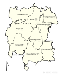 Chanditala-I CD block map showing GP areas
 Chanditala-II CD block map showing GP and urban areas
 Chinsurah-Mogra CD block map showing GP and urban areas
 Dhaniakhali CD block showing GP areas
 Goghat-I CD block map showing GP areas
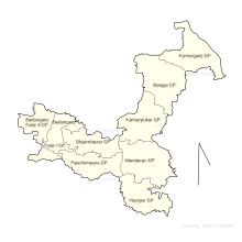 Goghat-II CD block showing GP areas
 Haripal CD block map showing GP areas
 Jangipara CD block map showing GP areas
 Khanakul-I CD block map showings GP areas
 Khanakul-II CD block Map showing GP areas
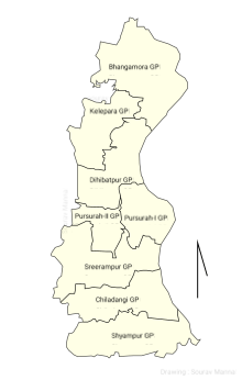 Pursurah CD block map showing GP areas
 Pandua CD block map showing GP areas
 Polba-Dadpur CD block map showing GP areas
 Singur CD block map showing GP and urban areas
 Seerampur-Uttarpara CD block map showing GP and urban areas
 Tarokeswr CD block map showing GP and urban areas
Assembly constituencies
The district is divided into 18 assembly constituencies:[4]
- Jangipara (assembly constituency no. 177),
- Chanditala (assembly constituency no. 178),
- Uttarpara (assembly constituency no. 179),
- Serampore (assembly constituency no. 180),
- Champdani (assembly constituency no. 181),
- Chandernagore (assembly constituency no. 189),
- Singur (assembly constituency no. 183),
- Haripal (assembly constituency no. 184),
- Tarakeswar (assembly constituency no. 185),
- Chinsurah (assembly constituency no. 186),
- Bansberia (assembly constituency no. 187),
- Balagarh (SC) (assembly constituency no. 188),
- Pandua (assembly constituency no. 189),
- Dhaniakhali (SC) (assembly constituency no. 191),
- Pursurah (assembly constituency no. 192),
- Khanakul (SC) (assembly constituency no. 193),
- Arambagh (assembly constituency no. 194) and
- Goghat (SC) (assembly constituency no. 195).
12 Balagarh, Dhaniakhali, Khanakul and Goghat constituencies are reserved for Scheduled Castes (SC) candidates. Along with two assembly constituencies from Howrah district, Jangipara, Chanditala, Uttarpara, Serampore and Champdani constituencies form the Serampore (Lok Sabha constituency). Chandernagore, Singur, Haripal, Chinsurah, Bansberia, Polba and Dhaniakhali constituencies form the Hooghly (Lok Sabha constituency).
Tarakeswar, Pursurah, Khankul, Arambag and Goghat constituencies are part of the Arambagh (Lok Sabha constituency), which contains two assembly segments in Paschim Medinipur district. Balagarh and Pandua constituencies are part of the Katwa (Lok Sabha constituency), which contains five assembly constituency from Bardhaman district.
Impact of delimitation of constituencies
As per order of the Delimitation Commission in respect of the delimitation of constituencies in the West Bengal, the district will be divided into 18 assembly constituencies:[5]
- Uttarpara (assembly constituency no. 185)
- Sreerampur (assembly constituency no. 186)
- Champdani (assembly constituency no. 187)
- Singur (assembly constituency no. 188)
- Chandannagar (assembly constituency no. 189)
- Chunchura (assembly constituency no. 190)
- Balagarh (SC) (assembly constituency no. 191)
- Pandua (assembly constituency no. 192)
- Saptagram (assembly constituency no. 193)
- Chanditala (assembly constituency no. 194)
- Jangipara (assembly constituency no. 195)
- Haripal (assembly constituency no. 196)
- Dhanekhali (SC) (assembly constituency no. 197)
- Tarakeswar (assembly constituency no. 198)
- Pursurah (assembly constituency no. 199)
- Arambag (SC) (assembly constituency no. 200)
- Goghat (SC) (assembly constituency no. 201)
- Khanakul (assembly constituency no. 202)
Balagarh, Dhanekhali, Arambag and Goghat constituencies will be reserved for Scheduled Castes (SC) candidates. Along with two assembly constituencies from Howrah district, Uttarpara, Sreerampur, Champdani, Chanditala and Jangipara constituencies will form the Sreerampur (Lok Sabha constituency). Singur, Chandannagar, Chunchura, Balagarh, Pandua, Saptagram and Dhanekhali constituencies will form the Hooghly (Lok Sabha constituency). Haripal, Tarakeswar, Pursurah, Arambag, Goghat and Khankul constituencies will be part of the Arambag (Lok Sabha constituency), which will contain one assembly segments in Paschim Medinipur district.
Police administration
Hooghly District comes under Burdwan Police Range. The police chief of the district is the superintendent of police. His office is in Chinsurah.
For the functioning of 23 police stations of the district, District Intelligence Branch, District Enforcement Branch and District Reserve Police Force SP, Hooghly is assisted by three additional superintendents:
- HQ: Having his office at Chinsurah, he looks after the Sadar Sub-Division and District Police Force, being assisted by Dy.S.P. (HQ) and Dy.S.P. (D&T).
- Industrial: He is in Serampore. He is the supervising officer for Serampore and Chandernagore Sub Divisions, assisted by SDPO: Serampore and SDPO: Chandernagore.
- Rural: He is in Arambagh and is the supervising officer for Arambagh Sub Division; being assisted by SDPO: Arambagh.
Transport
Rail
The railway communication of the district, especially at the suburban area, is very developed.
There are four junction stations in Hooghly:
- Bandel Junction railway station
- Dankuni Junction railway station
- Sheoraphuli railway station, Serampore
- Kamarkundu
The railway is under Howrah Division. The Howrah – New Delhi Rajdhani Route passes through the district, which is one of the most important routes of the country. This route comes under Howrah division and is under the jurisdiction of Sr Den/2/Hwh assisted by AEN/2/LLH. The first train of ER started its journey from Howrah to Hooghly on 14 August 1854 (First halt was Bally (Howrah) and second halt was Serampore). Hooghly station was announced as the heritage station.
Chinsurah railway station is very useful.
Demographics
According to the 2011 census Hooghly district has a population of 5,519,145,[6] roughly equal to the nation of Denmark[9] or the US state of Wisconsin.[10] This gives it a ranking of 16th in India (out of a total of 640).[6] The district has a population density of 1,753 inhabitants per square kilometre (4,540/sq mi).[6]
Its population growth rate over the decade 2001–2011 was 9.49%.[6] Hugli has a sex ratio of 958 females for every 1000 males,[6] and a literacy rate of 82.55%.[6]
| Historical population | ||
|---|---|---|
| Year | Pop. | ±% p.a. |
| 1901 | 1,076,416 | — |
| 1911 | 1,115,927 | +0.36% |
| 1921 | 1,105,907 | −0.09% |
| 1931 | 1,141,558 | +0.32% |
| 1941 | 1,415,934 | +2.18% |
| 1951 | 1,605,004 | +1.26% |
| 1961 | 2,231,288 | +3.35% |
| 1971 | 2,872,116 | +2.56% |
| 1981 | 3,557,306 | +2.16% |
| 1991 | 4,355,230 | +2.04% |
| 2001 | 5,041,976 | +1.47% |
| 2011 | 5,519,145 | +0.91% |
| source:[11] | ||
Education

There are 2992 primary schools, 408 high schools, 127 higher secondary schools, 22 colleges, and 6 technical institutes in Hooghly district.
The most notable institutions among them are:
- Hooghly Collegiate School, Estd. 1812
- Hooghly Mohsin College, Estd. 1836
- Sitapur Endowment Senior Madrasah - is established in 1751 as a part of Sitapur endowmant.
- Hooghly Madrasah - Haji Muhammad Mohsin established in 1817.[12]
- Furfura Fatehia Senior Madrasah Estd. 1902
- Government College of Engineering & Textile Technology Serampore
- Mahesh Sri Ramkrishna Ashram Vidyalaya (Higher Secondary)
- Saroj Mohan Institute of Technology, Guptipara
- Serampore College
- Serampore Girls' College
- Serampore Union Institution
- Akna Girl's High School
- Chatra Nandalal Institution
- Mahesh High School, Serampore
- Hooghly Branch (Govt) School
- St Joseph's Convent, Chandannagar
- Balagarh Bijoy Krishna Mahavidyalaya (Jirat College), Jirat
Historical places

- Kamarpukur is the birthplace of Sri Sri Ramakrishna dev.
- Tarakeswar is a renowned place of pilgrimage and the greatest centre of the Shiva sect in West Bengal.
- Serampore: The Ratha Yatra of Mahesh in Serampore is the oldest Ratha Yatra after Puri Ratha-Yatra. Serampore was the Danish colony. The first university in Asia was established in Serampore – Senate of Serampore College (University)
- Rishra: One of the most crowded cities has many different religions and industries like Aditya Birla's Jayashree textile. First jute mill of Asia was in Rishra. Arjuna Awardee Indian Footballer Sudhir Karmakar and Ex-Indian Football Captain Sishir Ghosh are from Rishra. Historical places to visit in Rishra Are Nilkuthi, Sidheshwari Kalibari, Bose House, Hesting jute mill, etc.
- Nalikul is famous for Raash Mela (রাস মেলা) & Rathayatra (রথযাত্রা) festivals. There is a big vegetable market.
- Bandel is famous for Bandel Church, West Bengal's oldest church. Bandel is the birthplace of the eminent writer Sarat Chandra Chattopadhyay.
- Chandannagar is an important town of Hooghly famous for Jagaddhatri puja, lighting work and French colonial monuments.
- Chinsurah is the district headquarters and a historical town of Hooghly. Bankim Chandra Chattopadhyay composed the "Vande Mataram," the national song of India, at Chinsurah. The Dutch villa is separated at Joraghat and Townguard. They are called 'Mondol Bari' as they are now under the aristocratic ownership of the Mondal family. One can see the Dutch lioness murals on the entrance doors and allied wooden motifs. In spite of such historical background, a major portion of the original Dutch villa at Townguard road, where once nationalist leaders used to hold meetings and conferences, was demolished and gone into the hands of builders/promoters. The back portion and the Joraghat Mondal house with Dutch acknowledgment are intact. The hierarchy of inheritance is becoming weak and the landmark assets need urgent preservation as well as heritage status application.
- Guptipara is famous for Rathayatra and Rashmela. There are few historical Terracotta temple in Brindabanchandra Math.
- The historical triple cities of Chandanagar-Chinsurah-Serampore are called Little Europe as these were all European colonies.
- Tribeni and Bansberia
- Khanakul birthplace of Raja Ram Mohan Roy.
- Furfura Sharif is the birthplace of the notable Sufi and social reformer Pir Abu Bakar.
See also
- Rathayatra of Mahesh, Serampore
References
- "Directory of District, Sub division, Panchayat Samiti/ Block and Gram Panchayats in West Bengal, March 2008". West Bengal. National Informatics Centre, India. 19 March 2008. Archived from the original on 25 February 2009. Retrieved 4 December 2008.
- "Municipal General Election 2005: Hooghly District". Official website of Hooghly district. Retrieved 13 December 2008.
- "Population, Decadal Growth Rate, Density and General Sex Ratio by Residence and Sex, West Bengal/ District/ Sub District, 1991 and 2001". West Bengal. Directorate of census operations. Archived from the original on 19 July 2011. Retrieved 4 December 2008.
- "General election to the Legislative Assembly, 2001–List of Parliamentary and Assembly Constituencies" (PDF). West Bengal. Election Commission of India. Archived from the original (PDF) on 4 May 2006. Retrieved 19 November 2008.
- "Press Note, Delimitation Commission" (PDF). Assembly Constituencies in West Bengal. Delimitation Commission. Retrieved 19 November 2008.
- "District Census 2011". Census2011.co.in. 2011. Retrieved 30 September 2011.
- http://www.censusindia.gov.in/2011census/C-16.html
- "DISTRIBUTION OF THE 22 SCHEDULED LANGUAGES-INDIA/STATES/UNION TERRITORIES - 2011 CENSUS" (PDF).
- US Directorate of Intelligence. "Country Comparison:Population". Retrieved 1 October 2011.
Denmark 5,529,888, July 2011 est.
- "2010 Resident Population Data". U. S. Census Bureau. Archived from the original on 19 October 2013. Retrieved 30 September 2011.
Wisconsin 5,686,986
- Decadal Variation In Population Since 1901
- TwoCircles.net. "Two-hundred-year-old Hooghly Madrasa facing closure – TwoCircles.net". Retrieved 1 February 2020.
External links
| Wikimedia Commons has media related to Hooghly. |
| Wikimedia Commons has media related to Map of CD Blocks in Hooghly District. |
- Hooghly District official homepage
- Hooghly specific information on West Bengal Portal
- Hooghly District map
- Hooghly District information
Places adjacent to Hooghly district | ||||||||||
|---|---|---|---|---|---|---|---|---|---|---|
| ||||||||||
| History |
| ||||||||||
|---|---|---|---|---|---|---|---|---|---|---|---|
| Geography |
| ||||||||||
| Governance |
| ||||||||||
| Division and Districts |
| ||||||||||
| Cities and towns |
| ||||||||||
| Culture |
| ||||||||||
| GI product |
| ||||||||||
| Demographics |
| ||||||||||
| People |
| ||||||||||