Begampur, India
Begampur is a census town in Chanditala II CD Block in Srirampore subdivision of Hooghly district in the state of West Bengal, India.[1]
Begampur | |
|---|---|
Census Town | |
 Begampur Location in West Bengal, India  Begampur Begampur (India) | |
| Coordinates: 22.7368°N 88.2518°E | |
| Country | |
| State | West Bengal |
| District | Hooghly |
| Nearest City | Serampore |
| Elevation | 15 m (49 ft) |
| Population (2011) | |
| • Total | 10,487 |
| Languages | |
| • Official | Bengali, English |
| Time zone | UTC+5:30 (IST) |
| PIN | 712306 |
| ISO 3166 code | IN-WB |
| Vehicle registration | WB |
| Lok Sabha constituency | Hooghly |
| Vidhan Sabha constituency | Singur |
| Website | wb |
Geography
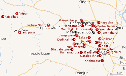 |
| Cities and towns in Chanditala I, Chanditala II and Jangipara CD Blocks in Srirampore subdivision in Hooghly district M: municipal city/ town, CT: census town, R: rural/ urban centre, Owing to space constraints in the small map, the actual locations in a larger map may vary slightly |
Location
Begampur is located at 22.7368°N 88.2518°E
Kharsarai, Tisa, Kapashanria, Jaykrishnapur, Purba Tajpur, Begampur, Baksa, Panchghara, Chikrand, Janai, Pairagachha, Naiti, Barijhati, Garalgachha and Krishnapur, all the census towns form a series from the northern part of Chanditala II CD Block to its southern part. The only municipality in the area, Dankuni, located outside the CD Block, occupies the south-east corner of the entire cluster.[2]
Urbanisation
Srirampore subdivision is the most urbanized of the subdivisions in Hooghly district. 73.13% of the population in the subdivision is urban and 26.88% is rural. The subdivision has 6 municipalities and 34 census towns. The municipalities are: Uttarpara Kotrung Municipality, Konnagar Municipality, Serampore Municipality, Baidyabati Municipality, Rishra Municipality and Dankuni Municipality. Amongst the CD Blocks in the subdivision, Uttarapara Serampore (census towns shown in a separate map) had 76% urban population, Chanditala I 42%, Chanditala II 69% and Jangipara 7% (census towns shown in the map above).[3][4]All places marked in the map are linked in the larger full screen map.
Demographics
As per 2011 Census of India, Begampur had a total population of 10,487 of which 5,405 (52%) were males and 5,082 (48%) were females. Population below 6 years was 802. The total number of literates in Begampur was 8,504 (87.81% of the population over 6 years).[4]
As of 2001 India census,[5] Begampur had a population of 9545. Males constitute 51% of the population and females 49%. Begampur has an average literacy rate of 75%, higher than the national average of 59.5%; with 53% of the literates being male and 47% being female. 9% of the population is under 6 years of age.
Dankuni Urban Agglomeration
As per the 2011 census, Dankuni Urban Agglomeration includes: Dankuni (M), Purba Tajpur (CT), Kharsarai (CT), Begampur (CT), Chikrand (CT), Pairagachha (CT), Barijhati (CT), Garalgachha (CT), Krishnapur (CT), Baruipara (CT), Borai (CT), Nawapara (CT), Basai (CT), Gangadharpur (CT), Manirampur (CT), Janai (CT), Kapashanria (CT), Jaykrishnapur (CT), Tisa (CT), Baksa (CT), Panchghara (CT) and Naiti (CT).[6]
Economy
Shantipur, Dhaniakhali, Begampur, and Farasdanga are the main cotton weaving centres in West Bengal which are involved in the weaving of fine-textured saris and dhotis. The saris of Begampur have deep and bright colours.[7] Begampur also produces the gorgeous jamdani saris.[8]
Around a total of 32 lakh people from all around the city commute to Kolkata daily for work. In the Howrah-Bardhaman (chord line) section there are 48 trains that carry commuters from 30 railway stations.[9]
Transport
Begampur railway station is situated 23 kilometres (14 mi) from Howrah on the Howrah-Bardhaman chord line and is part of the Kolkata Suburban Railway system.[10]
Education
Begampur High School is a coeducational higher secondary school at Begampur. It has arrangements for teaching Bengali, English, history, philosophy, political science, education, physics, chemistry, mathematics and bio science.[11][12]
Healthcare
Begampur has a Primary Health Centre with 6 beds.[13][14]
References
- "District-wise list of stautory towns". Census Commission of India. Archived from the original on 21 July 2011. Retrieved 28 January 2009.
- "Census of India 2011, West Bengal: District Census Handbook, Hooghly" (PDF). Map of Chanditala II CD Block, page 663. Directorate of Census Operations, West Bengal. Retrieved 4 October 2018.
- "District Statistical Handbook 2014 Hooghly". Table 2.2, 2.4(a). Department of Statistics and Programme Implementation, Government of West Bengal. Retrieved 3 October 2018.
- "C.D. Block Wise Primary Census Abstract Data(PCA)". 2011 census: West Bengal – District-wise CD Blocks. Registrar General and Census Commissioner, India. Retrieved 3 October 2018.
- "Census of India 2001: Data from the 2001 Census, including cities, villages and towns (Provisional)". Census Commission of India. Archived from the original on 16 June 2004. Retrieved 1 November 2008.
- "Constituents of urban Agglomerations Having Population 1 Lakh & above" (PDF). Provisional Population Totals, Census of India 2011. Retrieved 20 October 2018.
- "Crafts and Artisans of India". Textiles of West Bengal. craftandartisans.com. Archived from the original on 28 February 2009. Retrieved 28 January 2009.
- "World of the Indian Woman". Jamdani, the gorgeous saris of Bengal. Retrieved 28 January 2009.
- Dey, Teesta. "The Suburban Railway Network of Kolkata: A Geographical Apprisal" (PDF). eTraverse, the Indian journal of spatial science, 2012. Archived from the original (PDF) on 18 November 2017. Retrieved 8 October 2018.
- "36811 Howrah Bardhaman Local (via Chord)". indiarailinfo. Retrieved 6 October 2018.
- "Hooghly district exam venue". West Bengal Council of Higher Secondary Education. Retrieved 6 October 2018.
- "Begampur High School Hooghly". schoolspedia. Retrieved 6 October 2018.
- "Health & Family Welfare Department". Health Statistics. Government of West Bengal. Retrieved 4 October 2018.
- "Hooghly.gov.phc".
Cities, towns and locations in Hooghly District | |||||||||
|---|---|---|---|---|---|---|---|---|---|
| Cities, municipal and census towns |
| ||||||||
| Locations other than cities and towns |
| ||||||||
| Neighbourhoods | |||||||||
| Related topics |
| ||||||||