Saptagram
Saptagram (colloquially called Satgaon) was a major port, the chief city and sometimes capital of southern Bengal, in ancient and medieval times, the location presently being in the Hooghly district in the Indian state of West Bengal. It is about 4 km from Bandel, a major rail junction. By the early twentieth century, the place had dwindled to a group of insignificant huts.[1] The port had to be abandoned because of the silting up and consequent drying of the Saraswati River. It influenced the subsequent development and growth of Kolkata. H. E. A. Cotton writes, "Here then may be traced nucleus of the future city of Calcutta, and as time went on the silting up of the river opposite Satgaon still further favoured her fortunes."[1]
Etymology
The word Saptagram means seven villages. These are identified as Bansberia, Kristapur, Basudebpur, Nityanandapur, Sibpur, Sambachora and Baladghati.[2]
There is a mythological story attached to the name. King Priyabanta of Kannauj had seven sons – Agnitra, Medhatithi, Bapusman, Jyotisman, Dutisman, Saban and Bhabya. They were not happy with the royal life and so they set out in search of a place where they could carry out their meditation. When they came to the confluence of the Ganges, Jamuna and Saraswati, they liked the place and settled down in seven villages to a hermit's life. Thus grew Saptagram around the seven villages.[3]
Geography
Saraswati River, which used to take off from Hooghly River at Tribeni, 50 km north of Kolkata, ran parallel to the Hooghly River on its west.[4][5] Saraswati started drying up from the 17th century and ships, which navigated up the river, could no longer do so.[3]
Around the time when Bakhtiyar Khilji (1204–1206) came to Bengal, the region was divided into five parts – Rarh, Bagri, Vanga, Barendra and Mithila. Vanga was further subdivided into three parts – Lakhanabati, Subarnagram and Saptagram. When the frontiers of Bengal were expanded during Mughal rule, there were three prominent administrative zones in the area – Sirkar Satgaon, Sirkar Selimabad and Sirkar Mandaran.[3]
History
In Manasamangal by 15th-century poet Bipradas Pipilai
from Chandimangal by 16th-century poet Mukundaram[3]
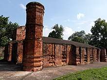
Earliest record suggests that the Muslim ruler Bahram Khan was first appointed the governor of Saptagram during 1324–1328 by Delhi Sultan Ghiyasuddin Tughlaq.[6][7] He had built a mosque at Saptagram collecting materials from many Hindu and Buddhist temples, thereby indicating the prosperity of Saptagram in the earlier Hindu and Buddhist periods.[8] It is the oldest mosque in Bengal.[9] There is another mosque named Sayed Jamaluddin Mosque which was built with terracotta ornamentation.[10]
When Bahram Khan was transferred to Sonargaon, Izzuddin Yahya was made the next governor of Saptagram in 1328. After his death in 1338, his deputy Shamsuddin Ilyas Shah took control and declared independence from Delhi.[11] Ilyas Shah annexed Lakhnauti in 1342 and Sonargaon in 1352 to his kingdom. Thus Saptagram became a part of whole unified Bengal for the first time in history.[11]
Portuguese settlement
The Portuguese called Saptagram Porto Pequeno (Little Haven); on the contrary Chittagong was Porto Grande (Great Haven). In 1533, the Portuguese Afonso de Melo arrived with five ships and a hundred men. They presented lavish gifts to the Sultan. However, instead of being pleased the Sultan put the Portuguese behind bars, because the gifts were stolen materials. A conflict situation arose. Messages were sent to the Portuguese governor at Goa. Chittagong port was set on fire. Diano Rebelo arrived at Saptagram with a force. Many thought that Sultan Ghiyasuddin Mahmud Shah would give a big fight. He did not. He released the Portuguese prisoners and granted them permission to trade at Chittagong and Saptagram. He had his own reasons; he wanted the support of the Portuguese in the internal struggle that was just unfolding.[3]
By 1535, the Portuguese were well settled in Saptagram. When Sher Khan attacked Saptagram, the Portuguese fought for the Sultan, but they withdrew their forces in 1538. The same year Sultan Ghiyasuddin Mahmud Shah was defeated. It was only after Sher Shah's death and the decline of Afghan supremacy that the Portuguese returned to Saptagram by around 1550.[3]
Travelers account
Traveler Ibn Battuta visited Satgaon in 1350.[12] From various records it is noted that local traders did not go abroad for trading but Arab, Persian and Turkish traders came to Saptagram for the purpose. The Portuguese started coming to Saptagram from the early 16th century.[3] Caesar Frederick, a Venetian who had travelled in the East from 1563 to 1581 and has left behind an account about some important cities, ports and business centres of India and of Bengal, mentions thirty to thirty five ships loaded with goods at Saptagram. Tomé Pires, a Portuguese traveller, did not visit Bengal but his work Suma Oriental written during 1512–1515 in India and Malacca gave an account of contemporary Bengal. He wrote, "It is a good city and rich where there are many merchants. It must have ten thousand inhabitants." Ralph Fitch, an English traveller and trader, mentioned "Satgaon is a fairy city of the Moors, and very plentiful of all things." In 1591, he thrilled London with the magnificent possibilities of Eastern commerce.[3][5]
Decline
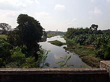
The silting of the river was taking its toll. Adi Ganga or present Tolly's Nullah was the outlet to the sea. The river was easily navigable for ocean-going ships up to Adi Ganga, beyond that only country boats operated. Betore on the western bank of the river had come up as a roaring trading centre. Many traders had started shifting to Hooghly. Gobindasharan Datta Chowdhury (also Raja Gobindasharan Dutta) made his way to the eastern bank of the river from Andul, and set up the village of Gobindapur, from 'Bada Rusa'. It was much later that Job Charnock came and landed at Sutanuti.[1] As the curtain wrung down over Saptagram, Kolkata started unfolding as a major metropolis.
Now, it is all quiet riverside, partly urbanised with an occasional factory chimney belching smoke in the distance. The Ishwar Gupta Setu, opened in 1989, linking Bandel with Kalyani offers a view of the Hooghly River.[9]
See also
- European colonies in India
- Saptagram (Vidhan Sabha constituency)
References
- Cotton, H.E.A., Calcutta Old and New, 1909/1980, p. 2, General Printers and Publishers Pvt. Ltd.
- "Temples of Bengal". Saptagram. hindubooks.org. Retrieved 5 August 2007.
- Patree, Purnendu (1995) [First published 1979]. Purano Kolkatar Kathachitra (in Bengali). Dey's Publishing. pp. 65–71. ISBN 81-7079-751-9.
- Gupta, Das; Prasad, Siva (1995). "The Site of Calcutta: Geology and Physiography". In Chaudhuri, Sukanta (ed.). Calcutta, the Living City. Vol. I. Oxford University Press. p. 17. ISBN 978-0-19-563696-3.
- Ray, Aniruddha (2012). "Satgaon". In Islam, Sirajul; Jamal, Ahmed A. (eds.). Banglapedia: National Encyclopedia of Bangladesh (Second ed.). Asiatic Society of Bangladesh.
- Khan, Muazzam Hussain (2012). "Tatar Khan". In Islam, Sirajul; Jamal, Ahmed A. (eds.). Banglapedia: National Encyclopedia of Bangladesh (Second ed.). Asiatic Society of Bangladesh.
- Bandopadhyay, Rakhaldas, Banglar Itihas (History of Bengal), 1971, (in Bengali), p. 8, Naba Bharat Publishers, 72 Mahatma Gandhi Road, Kolkata.
- Bandopadhyay, Rakhaldas, pp. 66–67
- Sengupta, Somen (23 October 2005). "Next weekend you can be at... Tribeni". The Telegraph. Retrieved 8 August 2007.
- "The Terracotta Mosques of Bengal". Retrieved 30 November 2018.
- Ahmed, ABM Shamsuddin (2012). "Ilyas Shah". In Islam, Sirajul; Jamal, Ahmed A. (eds.). Banglapedia: National Encyclopedia of Bangladesh (Second ed.). Asiatic Society of Bangladesh.
- Bandopadhyay, Rakhaldas, p. 81