Ichapore
Ichapore or Ichhapur is a locality in North Barrackpur Municipality of North 24 Parganas district in the Indian state of West Bengal. It is a part of the area covered by Kolkata Metropolitan Development Authority (KMDA). Ichhapur Defence Estate has two ordnance factories, the Rifle Factory Ishapore (RFI) and the Metal and Steel Factory (MSF) of the Ordnance Factories Board.
Ichapore Ichhapur | |
|---|---|
Neighbourhood | |
 Ichapore Location in West Bengal, India  Ichapore Ichapore (India) | |
| Coordinates: 22.81°N 88.37°E | |
| Country | |
| State | West Bengal |
| District | North 24 Parganas |
| Region | Greater Kolkata |
| Government | |
| • Type | Municipality |
| • Body | North Barrackpur Municipality |
| Elevation | 12 m (39 ft) |
| Languages | |
| • Official | Bengali, English |
| Time zone | UTC+5:30 (IST) |
| PIN | 743144 |
| Telephone code | +91 33 |
| Vehicle registration | WB |
| Lok Sabha constituency | Barrackpore |
| Vidhan Sabha constituency | Noapara |
| Website | north24parganas |
Geography
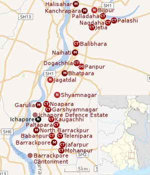 |
| Cities and towns in the northern portion of Barrackpore subdivision in North 24 Parganas district M: municipal city/ town, CT: census town, N: neighbourhood, OG: outgrowth Owing to space constraints in the small map, the actual locations in a larger map may vary slightly |
Location
Ichapore is located at 22.81°N 88.37°E. It has an average elevation of 12 m (39 ft).[1]
96% of the population of Barrackpore subdivision (partly presented in the map alongside) live in urban areas. In 2011, it had a density of population of 10,967 per km2 The subdivision has 16 municipalities and 24 census towns.[2]
For most of the cities/ towns information regarding density of population is available in the Infobox. Population data is not available for neighbourhoods. It is available for the entire municipal area and thereafter ward-wise.
All places marked on the map are linked in the full-screen map.
Ichapore is not identified in 2011 census as a separate location and may have been included in some other location.[3]In the Map of Barrackpore I CD Block on page 365 of District Census Handbook, Ichapore railway station and the entire area around Ichhapur Defence Estate is included in North Barrackpur municipality.[4]
Post Office
Ichapur has a non-delivery sub post office, with PIN 743144 in the North Presidency Division of North 24 Parganas district in Calcutta region. Other post offices with the same PIN are the Metal and Steel Factory, Anandamath, Ichapur Nawabganj, PS Bureau, Ichapur Rifle Factory and Kantadhar.[5][6]
References
- "Ichapore, India Page". West Bengal. Falling Rain Genomics. Retrieved 19 August 2008.
- "District Statistical Handbook". North 24 Parganas 2013, Tables 2.1, 2.2, 2.4b. Department of Statistics and Programme Implementation, Government of West Bengal. Retrieved 2 May 2018.
- "C.D. Block Wise Primary Census Abstract Data(PCA)". 2011 census: West Bengal – District-wise CD Blocks. Registrar General and Census Commissioner, India. Retrieved 23 March 2016.
- "District Census Handbook North Twenty Four Parganas, Census of India 2011, Series 20, Part XII A" (PDF). Map of Barrackpore I CD Block on Page 365. Directorate of Census Operations, West Bengal. Retrieved 21 June 2018.
- "Locate Post Offices". West Bengal. Postal Department. Retrieved 2 January 2017.
- "Ichapur PIN Code". pincodezip.in. Retrieved 11 July 2018.
External links
| Wikimedia Commons has media related to Ichhapur. |

North 24 Parganas district topics | |||||||||
|---|---|---|---|---|---|---|---|---|---|
| General |
| ||||||||
| Subdivisions | |||||||||
| Municipalities | |||||||||
| Community development blocks |
| ||||||||
| Rivers | |||||||||
| Transport |
| ||||||||
| Railway stations |
| ||||||||
| Institutes of higher learning |
| ||||||||
| Lok Sabha constituencies | |||||||||
| Vidhan Sabha constituencies |
| ||||||||
| Former Vidhan Sabha constituencies | |||||||||
| See also |
| ||||||||
| Kolkata Municipal Corporation |
|
|---|---|
| Kolkata Urban Agglomeration Outside KMC |
|
| |