Aushbati
Aushbati is a village in Chanditala I community development block of Srirampore subdivision in Hooghly district in the Indian state of West Bengal.[1]
Aushbati Ausbati | |
|---|---|
Village | |
 Aushbati Location in West Bengal, India  Aushbati Aushbati (India) | |
| Coordinates: 22.7483753°N 88.186575°E | |
| Country | |
| State | West Bengal |
| District | Hooghly |
| Government | |
| • Body | Gram panchayat |
| Population (2011) | |
| • Total | 2,246 |
| Languages | |
| • Official | Bengali, English |
| Time zone | UTC+5:30 (IST) |
| PIN | 712701 |
| ISO 3166 code | IN-WB |
| Vehicle registration | WB |
| Lok Sabha constituency | Serampore |
| Vidhan Sabha constituency | Chanditala |
| Website | wb |
Geography
Aushbati is located at: 22.7483753°N 88.186575°E.
Gram panchayat
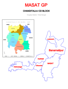
Villages and census towns in Masat gram panchayat are: Aushbati, Azabnagar, Banamalipur, Chhunche, Krishnanagar and Masat.[2]
Demographics
As per 2011 Census of India, Aushbati had a total population of 2,246 of which 1,140 (51%) were males and 1,106 (49%) were females. Population below 6 years was 250. The total number of literates in Aushbati was 1,525 (76.40% of the population over 6 years).[3]
Transport
Railway
Baruipara railway station, its nearest railway station, is on the Howrah-Bardhaman chord line and is a part of the Kolkata Suburban Railway system.[4][5]
Road
The main road is SH 15 (Ahilyabai Holkar Road). It is the main artery of the village and it is connected to NH 19 (old numbering NH 2)/ Durgapur Expressway.[5]
Bus
Private Bus
- 26 Bonhooghly - Champadanga
- 26A Serampore - Aushbati
Bus Routes without Numbers
- Howrah Station - Bandar (Dhanyaghori)
References
- "banglarbhumi.gov.in". WEST BENGAL ->HUGLI(হুগলী) ->CHANDITALA-I (চণ্ডীতলা-১) Mouza Information. Government of West Bengal. Archived from the original on 22 December 2016. Retrieved 6 October 2018.
- "Banamalipur". Indian Village Directory. Retrieved 12 October 2018.
- "C.D. Block Wise Primary Census Abstract Data(PCA)". 2011 census: West Bengal – District-wise CD Blocks. Registrar General and Census Commissioner, India. Retrieved 7 October 2018.
- "36811 Howrah Bardhaman Local (via Chord)". indiarailinfo. Retrieved 6 October 2018.
- Google maps
Cities, towns and locations in Hooghly District | |||||||||
|---|---|---|---|---|---|---|---|---|---|
| Cities, municipal and census towns |
| ||||||||
| Locations other than cities and towns |
| ||||||||
| Neighbourhoods | |||||||||
| Related topics |
| ||||||||