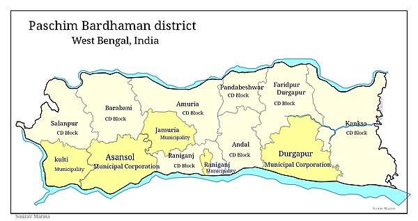
Salanpur (community development block)
Salanpur is a community development block that forms an administrative division in Asansol subdivision of Paschim Bardhaman district in the Indian state of West Bengal.
Salanpur | |
|---|---|
Community development block | |
 Salanpur Location in West Bengal | |
| Coordinates: 23°49′05″N 86°53′20″E | |
| Country | |
| State | West Bengal |
| District | Paschim Bardhaman |
| Parliamentary constituency | Asansol |
| Assembly constituency | Barabani |
| Area | |
| • Total | 52.14 sq mi (135.05 km2) |
| Elevation | 512 ft (156 m) |
| Population (2011) | |
| • Total | 160,357 |
| • Density | 3,100/sq mi (1,200/km2) |
| Time zone | UTC+5.30 (IST) |
| PIN | 713357 (Salanpur) 713364 (Rupnarayanpur Bazar) |
| Telephone/STD code | 0341 |
| Vehicle registration | WB-37, WB-38, WB-41, WB-42, WB-44 |
| Literacy Rate | 78.76 per cent |
| Website | http://bardhaman.gov.in/ |
Geography
Rupnarainpur, a gram panchayat in Salanpur CD Block, is located at 23°49′05″N 86°53′20″E.
Salanpur CD Block is part of the Ajay Damodar Barakar tract. This area is sort of an extension of the Chota Nagpur Plateau. It is a rocky undulating area with laterite soil, with the Ajay on the north, the Damodar on the south and the Barakar on the west. For ages the area was heavily forested and infested with plunderers and marauders. The discovery of coal, in the eighteenth century, led to industrialisation of the area and most of the forests have been cleared.[1][2]
Salanpur CD Block is bounded by Jamtara and Nala CD Blocks, in Jamtara district of Jharkhand, on the north, Barabani CD Block on the east, Asansol (municipal corporation) and after that Neturia CD Block, in Purulia district, on the south and Nirsa and Baliapur CD Blocks, in Dhanbad district of Jharkhand, on the west.[3]
Salanpur CD Block has an area of 135.05 km2. It has 1 panchayat samity, 11 gram panchayats, 96 gram sansads (village councils), 74 mouzas and 69 inhabited villages. Chittaranjan and Salanpur police stations serve this block.[4] Headquarters of this CD Block is at Rupnarayanpur.[5]
Nunia, a small stream about 40 km long has its origin near Adra village in the Salanpur area, flows through the Barabani area, past Asansol and joins the Damodar in the Raniganj area.[6]
Gram panchayats of Salanpur block/panchayat samiti are: Achhra, Alladi, Basudevpur-Jemari, Dendua, Ethora, Fulberia-Bolkunda, Jitpur-Uttarrampur, Kallya, Rupnarayanpur, Salanpur and Samdi.[7]
Demographics
Population
As per the 2011 Census of India Salanpur CD Block had a total population of 160,357, of which 101,360 were rural and 61,697 were urban. There were 83,796 (51%) males and 79,261 (49%) females. Population below 6 years was 17,118. Scheduled Castes numbered 39,294 (24.10%) and Scheduled Tribes numbered 17,084 (10.48%).[8]
As per 2001 census, Salanpur block had a total population of 156,338, out of which 82,741 were males and 73,597 were females. Salanpur block registered a population growth of 9.64 per cent during the 1991-2001 decade. Decadal growth for Bardhaman district was 14.36 per cent.[9] Decadal growth in West Bengal was 17.84 per cent.[10] Scheduled castes at 35,898 formed around one-fifth the population. Scheduled tribes numbered 17,143.[11]
Census Towns in Salanpur CD Block are (2011 census figures in brackets): Chittaranjan (39,098) and Hindusthan Cables Town (22,599).[8]
Large villages (with 4,000+ population) in Salanpur CD Block are (2011 census figures in brackets): Salanpur (4,739), Jemari (4,321), Ethora (4,547) and Kalya (703).[8]
Other villages in Salanpur CD Block include (2011census figures in brackets): Alladi (2,384), Dendua (2,297), Rupnarayanpur (2,242), Uttarrampur (1,331), Jitpur (1,532), Achhra (2,584), Phulberya (1,918), Bolkunda (1,351), Shyamdi (3,265) and Basudebpur (3,098).[8]
Literacy
As per the 2011 census the total number of literates in Salanpur CD Block was 114,940 (78.76% of the population over 6 years) out of which males numbered 64,520 (86.12% of the male population over 6 years) and females numbered 50,420 (70.99% of the female population over 6 years). The gender disparity (the difference between female and male literacy rates) was 15.13%.[8]
As per 2001 census, Salanpur block had a total literacy of 78.22 per cent for the 6+ age group. While male literacy was 87.07 per cent female literacy was 68.20 per cent. Bardhaman district had a total literacy of 70.18 per cent, male literacy being 78.63 per cent and female literacy being 60.95 per cent.[12]
See also – List of West Bengal districts ranked by literacy rate
| Literacy in CD Blocks of Bardhaman district |
|---|
| Bardhaman Sadar North subdivision |
| Ausgram I – 69.39% |
| Ausgram II – 68.00% |
| Bhatar – 71.56% |
| Burdwan I – 76.07% |
| Burdwan II – 74.12% |
| Galsi II – 70.05% |
| Bardhaman Sadar South subdivision |
| Khandaghosh – 77.28% |
| Raina I – 80.20% |
| Raina II – 81.48% |
| Jamalpur – 74.08% |
| Memari I – 74.10% |
| Memari II – 74.59% |
| Kalna subdivision |
| Kalna I – 75.81% |
| Kalna II – 76.25% |
| Manteswar – 73.08% |
| Purbasthali I – 77.59% |
| Purbasthali II – 70.35% |
| Katwa subdivision |
| Katwa I – 70.36% |
| Katwa II – 69.16% |
| Ketugram I – 68.00% |
| Ketugram II – 65.96% |
| Mongalkote – 67.97% |
| Durgapur subdivision |
| Andal – 77.25% |
| Faridpur Durgapur – 74.14% |
| Galsi I – 72.81% |
| Kanksa – 76.34% |
| Pandabeswar – 73.01% |
| Asansol subdivision |
| Barabani – 69.58% |
| Jamuria – 69.42% |
| Raniganj – 73.86% |
| Salanpur – 78.76% |
| Source: 2011 Census: CD Block Wise Primary Census Abstract Data |
Language and religion
As per census definition, mother-tongue is the language spoken in childhood by the person's mother to the person. As a mother-tongue, Bengali has decreased its share from 82.3% of the population of Bardhaman district in 1961 to 79.9% in 2001, Hindi has increased its share from 8.5% in 1961 to 10.9% in 2001 Santali has remained steady at around 4.9% during the period, and Urdu has increased its share from 2.4% in 1961 to 2.6% in 2001. Other mother-tongues spoken in 2001 were: Odiya (0.3%), Punjabi (0.2%), Koda/Kora (0.2%), Telugu (0.1%), Bhojpuri (0.1%), Nepali (0.1%) and Kurukh/ Oraon (0.1%).[13]
As of 2017, CD Block-wise/ other region-wise break-up of mother tongue is not available in census/ other official sources. There have been reports in the media about the Hindi speaking population being substantial in the Asansol (Lok Sabha constituency).[14][15] Bardhaman district provided attractive livelihood opportunities for immigrants from Bihar/ Jharkhand.[16]
According to the West Bengal Official Language Act 1961 and the West Bengal Official Language (Amendment Act) 2012, the Bengali language is to be used for official purposes in the whole of West Bengal. In addition to Bengali, the Nepali language is to be used for official purposes in the three hills subdivisions, namely Darjeeling, Kalimpong and Kurseong, in the district of Darjeeling, and Urdu is to be used for official purposes in district/subdivision/ block/ municipality where the population speaking Urdu exceeds 10% of the total population. The English language will continue to be used for official purposes as it was being used prior to the enactment of these laws.[17][18][19][20]
The West Bengal Official Language (Second Amendment) Bill, 2012, included Hindi, Santhali, Odiya and Punjabi as official languages if it is spoken by a population exceeding 10 per cent of the whole in a particular block or sub-division or a district. Subsequently, Kamtapuri, Rajbanshi and Kurmali were also included in the list of minority languages by the West Bengal Official Language (Second Amendment) Bill, 2018.[21][22] However, as of 2019, there is no official / other reliable information about the areas covered.
In the 2011 census Hindus numbered 153,776 and formed 94.31% of the population in Salanpur CD Block. Muslims numbered 5,825 and formed 3.57% of the population. Christians numbered 1,816 and formed 1.11% of the population. Others numbered 1,640 and formed 1.01% of the population.[23]
Rural poverty
As per poverty estimates obtained from household survey for families living below poverty line in 2005, rural poverty in Salanpur CD Block was 24.27%.[24]
Economy
Livelihood
Livelihood
in Salanpur CD Block
In Salanpur CD Block in 2011, amongst the class of total workers, cultivators numbered 2,291 and formed 4.41% of the total workers, agricultural labourers numbered 3,288 and formed 6.44%, household industry workers numbered 1,133 and formed 2.22% and other workers numbered 44.346 and formed 86.85%. Total workers numbered 51,058 and formed 31.31% of the total population, and non-workers numbered 111,999 and formed 68.69% of the population.[25]
Coalmines are spread across the Andal, Pandaveswar, Raniganj, Jamuria, Barabani and Salanpur region, including municipal areas. Livelihood in this region is coal-centred. The area does not produce much of agricultural products. Overall work participation rate, and female work participation rate, in the mining area are low. Interestingly the work participation rate in the predominantly agricultural rural areas of erstwhile Bardhaman district is higher than in the predominantly urbanised mining area. Human development in the mining area does not at all look good. However, in the composite livelihood index the mining area performs much better than the non-mining areas of erstwhile Bardhaman district. The decadal (1991-2001) change in composition of workers shows the growing pressure of population growth, as well as of migrants from adjacent Jharkhand.[26]
Note: In the census records a person is considered a cultivator, if the person is engaged in cultivation/ supervision of land owned by self/government/institution. When a person who works on another person's land for wages in cash or kind or share, is regarded as an agricultural labourer. Household industry is defined as an industry conducted by one or more members of the family within the household or village, and one that does not qualify for registration as a factory under the Factories Act. Other workers are persons engaged in some economic activity other than cultivators, agricultural labourers and household workers. It includes factory, mining, plantation, transport and office workers, those engaged in business and commerce, teachers, entertainment artistes and so on.[27]
Infrastructure
All 74 or 100% of mouzas in Salanpur CD Block were electrified by 31 March 2014.[28]
All 74 mouzas in Salanpur CD Block had drinking water facilities in 2013–14. There were 9 fertiliser depots, 3 seed stores and 32 fair price shops in the CD Block.[28]
Coal mining
Coal mining in India first started in the Raniganj Coalfield. In 1774, John Sumner and Suetonius Grant Heatly of the British East India Company found coal near Ethora, presently in Salanpur CD Block.[29]
See also – Salanpur Area and Sodepur Area of Eastern Coalfields
Mohanpur open cast project in Salanpur Area of Eastern Coalfields is undergoing expansion to 2.5 million tonnes per year.[30][31] Gourandi Extension In Salanpur Area of Eastern Coalfields has a mineable reserve of 15.44 million tonnes.[31]
With extensive underground mining for many years, this area has been facing the problem of land subsidence. About 361 villages under the Raniganj and Salanpur coalfield areas are the victims of subsidence.[32]
Industry
Chittaranjan Locomotive Works at Chittaranjan is one of the largest electric locomotive manufacturers in the world. Established in 1950, it produced steam locomotives up to 1972. It is named after the great Indian independence movement activist, Chittaranjan Das.[33]
The Rupnarayanpur unit of Hindustan Cables was closed on 1 February 2017.[34] Hindustan Cables was set up in 1952 at Rupnarayanpur. It later set up units at Hyderabad and Naini, Allahabad. Both the Rupnarayanpur and Hyderabad units, which produced polythene insulated jelly filled cables, had stopped producing in 2003, as BSNL and MTNL did not need such cables anymore.[35]
Bhushan Steel signed an agreement with the West Bengal government to set a 2 million tonne steel plant, with auxiliary facilities, at Salanpur, in 2007. The company expected to get around 2,500 acres of land acquired in the subsequent one year and start production in 2012.[36] With growing resistance to land acquisition the state government was not able to make much headway.[37] In 2012, Bhusan Steel put the project on hold.[38]
Agriculture
Although the Bargadari Act of 1950 recognised the rights of bargadars to a higher share of crops from the land that they tilled, it was not implemented fully. Large tracts, beyond the prescribed limit of land ceiling, remained with the rich landlords. From 1977 onwards major land reforms took place in West Bengal. Land in excess of land ceiling was acquired and distributed amongst the peasants.[39] Following land reforms land ownership pattern has undergone transformation. In 2013–14, persons engaged in agriculture in Salanpur CD Block could be classified as follows: bargadars 2.44%, patta (document) holders 37.94%, small farmers (possessing land between 1 and 2 hectares) 5.68%, marginal farmers (possessing land up to 1 hectare) 27.08% and agricultural labourers 26.86%.[28]
In 2003-04 net cropped area in Salanpur CD Block was 4,681 hectares and the area in which more than one crop was grown was 946 hectares.[40]
In 2013–14, Salanpur CD Block produced 17,215 tonnes of Aman paddy, the main winter crop, from 8,142 hectares. It also produced pulses.[28]
Banking
In 2013–14, Salanpur CD Block had offices of 7 commercial banks and 2 gramin banks.[28]
Transport
Salanpur CD Block has 6 originating/ terminating bus routes.[28]
| Asansol–Patna section | ||||||||||||||||||||||||||||||||||||||||||||||||||||||||||||||||||||||||||||||||||||||||||||||||||||||||||||||||||||||||||||||||||||||||||||||||||||||||||||||||||||||||||||||||||||||||||||||||||||||||||||||||||||||||||||||||||||||||||||||||||||||||||||||||||||||||||||||||||||||||||||||||||||||||||||||||||||||||||||||||||||||||||||||||||||||||||||||||||||||||||||||||||||||||||||||||||||||||||||||||||||||||||||||||||||||||||||||||||||||||||||||||||||||||||||||||||||||||||||||||||||||||||||||||||||||||||||||||||||||||||||||||||||||||||||||||||||||||||||||||||||||||||||||||||||||||||||||||||||||||||||||||||||||||||||||||||||||||||||||||||||||||||||
|---|---|---|---|---|---|---|---|---|---|---|---|---|---|---|---|---|---|---|---|---|---|---|---|---|---|---|---|---|---|---|---|---|---|---|---|---|---|---|---|---|---|---|---|---|---|---|---|---|---|---|---|---|---|---|---|---|---|---|---|---|---|---|---|---|---|---|---|---|---|---|---|---|---|---|---|---|---|---|---|---|---|---|---|---|---|---|---|---|---|---|---|---|---|---|---|---|---|---|---|---|---|---|---|---|---|---|---|---|---|---|---|---|---|---|---|---|---|---|---|---|---|---|---|---|---|---|---|---|---|---|---|---|---|---|---|---|---|---|---|---|---|---|---|---|---|---|---|---|---|---|---|---|---|---|---|---|---|---|---|---|---|---|---|---|---|---|---|---|---|---|---|---|---|---|---|---|---|---|---|---|---|---|---|---|---|---|---|---|---|---|---|---|---|---|---|---|---|---|---|---|---|---|---|---|---|---|---|---|---|---|---|---|---|---|---|---|---|---|---|---|---|---|---|---|---|---|---|---|---|---|---|---|---|---|---|---|---|---|---|---|---|---|---|---|---|---|---|---|---|---|---|---|---|---|---|---|---|---|---|---|---|---|---|---|---|---|---|---|---|---|---|---|---|---|---|---|---|---|---|---|---|---|---|---|---|---|---|---|---|---|---|---|---|---|---|---|---|---|---|---|---|---|---|---|---|---|---|---|---|---|---|---|---|---|---|---|---|---|---|---|---|---|---|---|---|---|---|---|---|---|---|---|---|---|---|---|---|---|---|---|---|---|---|---|---|---|---|---|---|---|---|---|---|---|---|---|---|---|---|---|---|---|---|---|---|---|---|---|---|---|---|---|---|---|---|---|---|---|---|---|---|---|---|---|---|---|---|---|---|---|---|---|---|---|---|---|---|---|---|---|---|---|---|---|---|---|---|---|---|---|---|---|---|---|---|---|---|---|---|---|---|---|---|---|---|---|---|---|---|---|---|---|---|---|---|---|---|---|---|---|---|---|---|---|---|---|---|---|---|---|---|---|---|---|---|---|---|---|---|---|---|---|---|---|---|---|---|---|---|---|---|---|---|---|---|---|---|---|---|---|---|---|---|---|---|---|---|---|---|---|---|---|---|---|---|---|---|---|---|---|---|---|---|---|---|---|---|---|---|---|---|---|---|---|---|---|---|---|---|---|---|---|---|---|---|---|---|---|---|---|---|---|---|---|---|---|---|---|---|---|---|---|---|---|---|---|---|---|---|---|---|---|---|---|---|---|---|---|---|---|---|---|---|---|---|---|---|---|---|---|---|---|---|---|---|---|---|---|---|---|---|---|---|---|---|---|---|---|---|---|---|---|---|---|---|---|---|---|---|---|---|---|---|---|---|---|---|---|---|---|---|---|---|---|---|---|---|---|---|---|---|---|---|---|---|---|---|---|---|---|---|---|---|---|---|---|---|---|---|---|---|---|---|---|---|---|---|---|---|---|---|---|
| ||||||||||||||||||||||||||||||||||||||||||||||||||||||||||||||||||||||||||||||||||||||||||||||||||||||||||||||||||||||||||||||||||||||||||||||||||||||||||||||||||||||||||||||||||||||||||||||||||||||||||||||||||||||||||||||||||||||||||||||||||||||||||||||||||||||||||||||||||||||||||||||||||||||||||||||||||||||||||||||||||||||||||||||||||||||||||||||||||||||||||||||||||||||||||||||||||||||||||||||||||||||||||||||||||||||||||||||||||||||||||||||||||||||||||||||||||||||||||||||||||||||||||||||||||||||||||||||||||||||||||||||||||||||||||||||||||||||||||||||||||||||||||||||||||||||||||||||||||||||||||||||||||||||||||||||||||||||||||||||||||||||||||||
The Asansol-Patna section of the Howrah-Delhi main line passes through this CD Block. There are stations at Salanpur and Rupnarayanpur,[41]
The Kolkata-Delhi NH 19 (old numbering NH 2) passes through this block.[42]
State Highway 5 (West Bengal) running from Rupnarayanpur (in Bardhaman district) to Junput (in Purba Medinipur district) originates from this block.[43]
Asansol-Chittaranjan road links to both NH 19 and Grand Trunk Road and thereafter it links to Jamtara in Jharkhand and from there to places such as Dumka and Karmatanr.[44]
Education
In 2013–14, Salanpur CD Block had 75 primary schools with 10,260 students, 4 middle schools with 379 students, 6 high schools with 3,634 students and 9 higher secondary schools with 7,894 students. Salanpur CD Block had 1 general college with 1,411 students, 5 technical/ professional institution with 730 students and 274 institutions for special and non-formal education with 9,079 students.[28]
Deshbandhu Mahavidyalaya was established at Chittaranjan in 1973. It is affiliated with the Kazi Nazrul University.[45]
Culture
Kalyaneshwari Temple is a 500-year-old centre of Shakti worship. Legend has it that human sacrifices were offered at Kalyaneshwari in the remote past. The present temple, however, is not very old and was constructed by Panchakot Raj. The temple of Goddess Kalyaneshwari is believed to fulfill the wishes of childless women.[46][47]
Healthcare
In 2014, Salanpur CD Block had 1 block primary health centre, 3 primary health centres, 2 medical institutions of central government/ PSUs and 2 private nursing homes with total 517 beds and 52 doctors (excluding private bodies). It had 13 family welfare sub centres. 10,229 patients were treated indoor and 117,995 patients were treated outdoor in the hospitals, health centres and subcentres of the CD Block.[28]
Pithaikeary Rural Hospital, with 30 beds, at Rupnarayanpur, is the major government medical facility in the Salanpur CD block. There are primary health centres at Dabor, PO Achra (with 10 beds), and Parbotpur, PO Samdi (with 2 beds).[48][49] Kasturba Gandhi Hospital at Chittaranjan functions with 150 beds.[50]
References
- "Census of India 2011, West Bengal: District Census Handbook, Barddhaman" (PDF). Physiography, pages 13-14. Directorate of Census Operations, West Bengal. Retrieved 23 January 2017.
- Chattopadhyay, Akkori, Bardhaman Jelar Itihas O Lok Sanskriti (History and Folk lore of Bardhaman District.), (in Bengali), Vol I, pp 14-15, Radical Impression. ISBN 81-85459-36-3
- "Tehsil Map of Barddhaman". CD Block/ Tehsil. Maps of India. Retrieved 23 January 2017.
- "District Statistical Handbook 2014 Burdwan". Tables 2.1, 2.2. Department of Statistics and Programme Implementation, Government of West Bengal. Archived from the original on 29 July 2017. Retrieved 22 January 2017.
- "District Census Handbook: Barddhaman" (PDF). Map of Barddhaman with CD Block HQs and Police Stations (on the fourth page). Directorate of Census Operations, West Bengal, 2011. Retrieved 22 January 2017.
- Chattopadhyay, Akkori, pp 26-27
- "Directory of District, Subdivision, Panchayat Samiti/ Block and Gram Panchayats in West Bengal". Bardhaman - Revised in March 2008. Panchayats and Rural Development Department, Government of West Bengal. Retrieved 30 January 2017.
- "C.D. Block Wise Primary Census Abstract Data(PCA)". 2011 census: West Bengal – District-wise CD Blocks. Registrar General and Census Commissioner, India. Retrieved 16 January 2017.
- "Provisional population totals, West Bengal, Table 4, Barddhaman District". Census of India 2001. Census Commission of India. Archived from the original on 28 September 2011. Retrieved 4 February 2017.
- "Provisional Population Totals, West Bengal. Table 4". Census of India 2001. Census Commission of India. Archived from the original on 27 September 2007. Retrieved 4 February 2017.
- "TRU for all Districts (SC & ST and Total)". Census 2001. Census Commission of India. Archived from the original on 19 July 2011. Retrieved 4 February 2017.
- "Provisional population totals, West Bengal, Table 5, Bardhaman District". Census of India 2001. Census Commission of India. Archived from the original on 2011-09-28. Retrieved 2011-08-26.
- "Census of India 2011, West Bengal: District Census Handbook, Barddhaman" (PDF). Mother-tongue: Table 11, page 51. Directorate of Census Operations, West Bengal. Retrieved 7 April 2018.
- "Red Corridors in West Bengal a Headache for EC". The New Indian Express, 7 May 2014. Retrieved 28 January 2017.
- "Hindi speaking voters 'Modi'fied, Didi looks for answers". Maps of India, 1 April 2014. Retrieved 28 January 2017.
- "District Human Development Report: Bardhaman" (PDF). Chapter I, Page 8. Development and Planning Department, Government of West Bengal, 2011. Retrieved 28 January 2017.
- "West Bengal Official Language Act 1961". Latest Laws.com. Retrieved 10 May 2020.
- "The West Bengal Official Language Act 1961". Advocate Tanmoy Law Library. Retrieved 10 May 2020.
- "The West Bengal Official Language Act, 1961" (PDF). Retrieved 10 May 2020.
- "Official status for Urdu in some West Bengal Areas". The Hindu, 2 April 2012. Retrieved 10 May 2020.
- "Multilingual Bengal". The Telegraph, 11 December 2012. Retrieved 15 January 2019.
- "Kamtapuri, Rajbanshi make it to the list of official languages in Bengal". Outlook, 28 February 2015. Retrieved 15 January 2019.
- "C1 Population by Religious Community". West Bengal. Registrar General and Census Commissioner, India. Retrieved 27 January 2017.
- "District Human Development Report: Bardhaman" (PDF). Table 4.2: Empirical Measurement of Rural Poverty in Bardhaman 2005, page 94. Development and Planning Department, Government of West Bengal, 2011. Retrieved 30 January 2017.
- "District Census Handbook Bardhaman, Census of India 2011, Series 20, Part XII A" (PDF). Page 96, Table 33: Distribution of Workers by Sex in Four Categories ofEconomic Activity in Sub-district 2011; Page 86, Table 30: Number and Percentage of Main Workers, Marginal Workers and Non-workers by sex in sub-districts, 2011. Directorate of Census Operations, West Bengal. Retrieved 22 September 2018.
- "District Human Development Report: Bardhaman". Pages 294-300. Department of Planning, Statistics and Programme monitoring, Government of West Bengal, 2011. Retrieved 22 September 2018.
- "District Census Handbook Bardhaman, Census of India 2011, Series 20, Part XII A" (PDF). Census Concepts and Definitions, Page 33. Directorate of Census Operations, West Bengal. Retrieved 22 September 2018.
- "District Statistical Handbook 2014 Bardhaman". Tables 2.7, 2.1, 8.2, 16.1, 17.2, 18.1, 18.2, 20.1, 21.2, 4.4, 3.1, 3.3 – arranged as per use. Department of Statistics and Programme Implementation, Government of West Bengal. Retrieved 30 January 2017.
- Akkori Chattopadhyay, Bardhaman Jelar Itihas O Lok Sanskriti , Vol I, pp. 46-51, (Bengali), Radical, 2001, ISBN 81-85459-36-3
- "Accepte Project Details". Ministry of Coal, Government of India. Retrieved 30 January 2017.
- "Planning". Eastern Coalfields Limited. Retrieved 30 January 2017.
- "Subsidence claims 20 houses near ECL hub". Bengal. The Statesman 28 November 2004. Archived from the original on 29 September 2007. Retrieved 2007-09-05.
- "Chittaranjan Locomotive Works". Indian Railways. Retrieved 5 February 2017.
- "आज से बंद होगी हिन्दुस्तान केबल्स फैक्ट्री (Hindustan Cables Factory To Be Closed From Today". Hindi. Hindustan.com, 1 February 2017. Retrieved 5 February 2017.
- "Government will offer 'attractive VRS' to Hindustan Cables emplyees: Minister". The Hindu Business Line, 3 January 2017. Retrieved 5 February 2017.
- "Bhusan Steel to invest Rs. 8,800 crore in West Bengal". Rebuilding Bharat. Retrieved 5 February 2017.
- "Salanpur land hearing put off". Business Standard, 29 November 2010. Retrieved 5 February 2017.
- "Bhusan Steel's Bengal Plant Land in Acquisition Trouble". The Economic Times, 3 January 2012. Retrieved 30 January 2017.
- "District Human Development Report: South 24 Parganas". (1) Chapter 1.2, South 24 Parganas in Historical Perspective, pages 7-9 (2) Chapter 3.4, Land reforms, pages 32-33. Development & Planning Department, Government of West Bengal, 2009. Retrieved 7 August 2016.
- "District Human Development Report, Bardhaman" (PDF). Table 3.10, Gross Cropped Area, Net Cropped Area and Cropping Intensity of different blocks of Bardhaman district 2003-04, Page 53. Development and Planning Department, Government of West Bengal, May 2011. Retrieved 30 January 2017.
- "73539 Andal-Jasidih DEMU". Time Table. indiarailinfo. Retrieved 5 February 2017.
- "Rationalisation of Numbering Systems of National Highways" (PDF). New Delhi: Department of Road Transport and Highways. Retrieved 5 February 2017.
- "List of State Highways in West Bengal". West Bengal Traffic Police. Retrieved 5 February 2017.
- Google maps
- "Deshbandhu Mahavidyalaya". DM. Retrieved 2 March 2017.
- Ghosh, Binoy, Paschim Banger Sanskriti, (in Bengali), part I, 1976 edition, p. 221, Prakash Bhaban
- "Kalyaneshwari Temple". india9.com. Retrieved 9 February 2017.
- "Health & Family Welfare Department" (PDF). Health Statistics – Rural Hospitals. Government of West Bengal. Retrieved 12 May 2020.
- "Health & Family Welfare Department" (PDF). Health Statistics – Primary Health Centres. Government of West Bengal. Retrieved 12 May 2020.
- "Health & Family Welfare Department" (PDF). Health Statistics - Hospitals. Government of West Bengal. Retrieved 12 May 2020.