Kumirmora
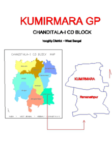
Kumirmora is a census town in Chanditala I CD Block in Srirampore subdivision of Hooghly district in the state of West Bengal, India.
Kumirmora | |
|---|---|
Census Town | |
 Kumirmora Location in West Bengal, India  Kumirmora Kumirmora (India) | |
| Coordinates: 22.6968602°N 88.2267446°E | |
| Country | |
| State | West Bengal |
| District | Hooghly |
| Nearest City | Serampore |
| Population (2011) | |
| • Total | 12,208 |
| Languages | |
| • Official | Bengali, English |
| Time zone | UTC+5:30 (IST) |
| Vehicle registration | WB |
| Lok Sabha constituency | Serampore |
| Vidhan Sabha constituency | Chanditala |
| Website | wb |
Geography
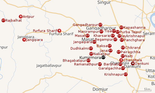 |
| Cities and towns in Chanditala I, Chanditala II and Jangipara CD Blocks in Srirampore subdivision in Hooghly district M: municipal city/ town, CT: census town, R: rural/ urban centre, Owing to space constraints in the small map, the actual locations in a larger map may vary slightly |
Location
Kumirmora is located at 22.6968602°N 88.2267446°E.
Gangadharpur, Manirampur, Masat, Jangalpara, Dudhkalmi, Nababpur, Bhagabatipur, Kumirmora and Ramanathpur form a cluster of census towns in Chanditala I CD Block.[1]
Urbanisation
Srirampore subdivision is the most urbanized of the subdivisions in Hooghly district. 73.13% of the population in the subdivision is urban and 26.88% is rural. The subdivision has 6 municipalities and 34 census towns. The municipalities are: Uttarpara Kotrung Municipality, Konnagar Municipality, Serampore Municipality, Baidyabati Municipality, Rishra Municipality and Dankuni Municipality. Amongst the CD Blocks in the subdivision, Uttarapara Serampore (census towns shown in a separate map) had 76% urban population, Chanditala I 42%, Chanditala II 69% and Jangipara 7% (census towns shown in the map above).[2][3]All places marked in the map are linked in the larger full screen map.
Demographics
As per 2011 Census of India Kumirmora had a total population of 12,208 of which 6,063 (50%) were males and 6,145 (50%) were females. Population below 6 years was 1,369. The total number of literates in Kumirmora was 9,053 (83.52 % of the population over 6 years).[3]
Transport
Railway and road
Janai Road railway station is the nearest railway station on the Howrah-Bardhaman chord of Kolkata Suburban Railway network. The main road is SH 15 (Ahilyabai Holkar Road). It is the main road of the town and is connected to NH 19 (old number NH 2).
Bus Routes
Private Bus Routes
- 26 Bonhooghly - Champadanga
- 26A Serampore - Aushbati
- 26C Bonhooghly - Jagatballavpur
Bus Routes without Numbers
- Howrah Station - Bandar (Dhanyaghori)
- Dakshineswar - Bhagabatipur
References
- "Census of India 2011, West Bengal: District Census Handbook, Hooghly" (PDF). Map of Chanditala I CD Block, page 649. Directorate of Census Operations, West Bengal. Retrieved 4 October 2018.
- "District Statistical Handbook 2014 Hooghly". Table 2.2, 2.4(a). Department of Statistics and Programme Implementation, Government of West Bengal. Retrieved 3 October 2018.
- "C.D. Block Wise Primary Census Abstract Data(PCA)". 2011 census: West Bengal – District-wise CD Blocks. Registrar General and Census Commissioner, India. Retrieved 3 October 2018.
Cities, towns and locations in Hooghly District | |||||||||
|---|---|---|---|---|---|---|---|---|---|
| Cities, municipal and census towns |
| ||||||||
| Locations other than cities and towns |
| ||||||||
| Neighbourhoods | |||||||||
| Related topics |
| ||||||||