Kanchrapara
Kanchrapara is a city and a municipality[1] of North 24 Parganas district in the Indian state of West Bengal. It is a part of the area covered by Kolkata Metropolitan Development Authority (KMDA).
Kanchrapara | |
|---|---|
City | |
.jpg) | |
 Kanchrapara Location in West Bengal, India  Kanchrapara Kanchrapara (India) | |
| Coordinates: 22.94563°N 88.43322°E | |
| Country | |
| State | West Bengal |
| District | North 24 Parganas |
| Region | Greater Kolkata |
| Government | |
| • Type | Municipality |
| • Body | Kanchrapara Municipality |
| • Chairman | Sudama Ray |
| Area | |
| • Total | 9.06 km2 (3.50 sq mi) |
| Elevation | 10 m (30 ft) |
| Population (2011) | |
| • Total | 129,576 |
| • Density | 14,000/km2 (37,000/sq mi) |
| Languages | |
| • Official | Bengali, English |
| Time zone | UTC+5:30 (IST) |
| PIN | 743145 |
| Telephone code | +91 33 |
| Vehicle registration | WB |
| Lok Sabha constituency | Barrackpore |
| Vidhan Sabha constituency | Bijpur |
| Website | north24parganas |
History
From early historical period, geographically, this area had been full of swamps, natural riverine lake, low land, water bodies sparse village-settlements surrounded by deep jungle infested with wild animals of all kinds. Barring a few pockets, the area was considered unfit for human habitation.
However, around this area, there were several dozen villages more or less prosperous, such as Mallickbaag, Kanchanpalli or Kanchrapara, Bhawanipur, Ghoshpara, Chandua and Kampa. This area underwent development from 1862- the Sealdaha Kusthia Broad Gauge Railway Line, through 1863- construction of a 132000 m² locomotive workshop and railway station on the northernmost tip of Bizpur Mouza, undertaken by Eastern Bengal State Railway. In 1914 a carriage and wagon shop were added. Subsequently, a planned Railway Township was laid and built to the East & South West of the Workshops with a wide range of infrastructure - roads, drains, bridges, street lights, internal Railway lines, parks, Institutes, Administrative Buildings, Technical School, Hospital, Co-operative shopping stores, Bazaar, playgrounds for football, Tennis, golf, theatre attached to each institute (Hindmarsh Institute, Bell Institute, Spalding Institute), Officers’ Club etc. The resulting population increase caused the construction of huts and pucca buildings, necessitating the expansion of Municipal infrastructure beyond the Railway area.
This city was named Kanchrapara since the Railway Station at Bijpur was named after the then village Kanchanpalli or Kanchrapara. It was prosperous economically and culturally, being the seat of many stalwarts of Baishnab literature and early Bengali literature, as well as famous Vaidyas.[2]
Geography
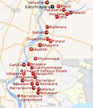 |
| Cities and towns in the northern portion of Barrackpore subdivision in North 24 Parganas district M: municipal city/ town, CT: census town, N: neighbourhood, OG: outgrowth Owing to space constraints in the small map, the actual locations in a larger map may vary slightly |
Location
Kanchrapara is located at 22.56°N 88.26°E.[3] It has an average elevation of 10 metres (32 feet).
Kanchrapara is bounded by Kalyani and Gayespur in Nadia district on the north, Jayanpur, Palladaha, Kanpa, Srotribati, Chandua and Jetia on the east and Halisahar on the south and west. Bijpur is a neighbourhood in Kanchrapara.[4][5]
96% of the population of Barrackpore subdivision (partly presented in the map alongside) lives in urban areas. In 2011, it had a density of population of 10,967 per km2 The subdivision has 16 municipalities and 24 census towns.[6]
For most of the cities/ towns information regarding density of population is available in the Infobox. Population data is not available for neighbourhoods. It is available for the entire municipal area and thereafter ward-wise.
All places marked on the map are linked in the full-screen map.
Neighbourhoods
Kanchrapara railway station is in the city's north-east. One enters the central market area through the Station Road, which is a two-lane road. Then is the central roundabout of the city, the city's heart - Gandhi More. One road from Gandhi More leads to the 1.5 km long Workshop Road off to the esteemed Kanchrapara Railway Workshop towards the south and another road, the backbone of Kanchrapara - Kabi Guru Rabindra (K.G.R.) Path, which is a 4 km long road running eastwards from Gandhi More till it merges with Rani Rashmani Ghat Road, at Bagmore, the city's easternmost locality.
Police station
Bijpur police station under Barrackpore Police Commissionerate has jurisdiction over Kanchrapara and Halisahar Municipal areas.[7][8]
Post Office
Kanchrapara has a delivery sub post office, with PIN 743145 in the North Presidency Division of North 24 Parganas district in Calcutta region. The other post offices with the same PIN are Bagermore, Binodnagar, Chandmari Road, Palashi, Kanchrapara Loco Shop, Barajonepur, Chendua, Majhipara and Saliadaha.[9]
Demographics
Population
| Population of Kanchrapara | |||
|---|---|---|---|
| Census | Population | %± | |
| 1921 | 10,332 | — | |
| 1931 | 15,005 | 45.2% | |
| 1941 | 24,015 | 60.0% | |
| 1951 | 56,668 | 136.0% | |
| 1961 | 68,966 | 21.7% | |
| 1971 | 78,768 | 14.2% | |
| 1981 | 98,816 | 25.5% | |
| 1991 | 111,602 | 12.9% | |
| 2001 | 135,198 | 21.1% | |
| 2011 | 129,576 | −4.2% | |
| Source:[10] | |||
As per the 2011 Census of India, Kanchrapara (municipal area + outgrowth) had a total population of 129,576, of which 65,436 (51%) were males and 64,140 (49%) were females. Population below 6 years was 9,947. The total number of literates in Kanchrapara was 108,092 (90.36% of the population over 6 years).[11]
As of 2001 India census,[12] Kanchrapara had a population of 126,118. Males constitute 52% of the population and females 48%. Kanchrapara has an average literacy rate of 81%, higher than the national average of 59.5%: male literacy is 86%, and female literacy is 76%. In Kanchrapara, 8% of the population is under 6 years of age.
Kolkata Urban Agglomeration
The following Municipalities, Census Towns and other locations in Barrackpore subdivision were part of Kolkata Urban Agglomeration in the 2011 census: Kanchrapara (M), Jetia (CT), Halisahar (M), Balibhara (CT), Naihati (M), Bhatpara (M), Kaugachhi (CT), Garshyamnagar (CT), Garulia (M), Ichhapur Defence Estate (CT), North Barrackpur (M), Barrackpur Cantonment (CB), Barrackpore (M), Jafarpur (CT), Ruiya (CT), Titagarh (M), Khardaha (M), Bandipur (CT), Panihati (M), Muragachha (CT) New Barrackpore (M), Chandpur (CT), Talbandha (CT), Patulia (CT), Kamarhati (M), Baranagar (M), South Dumdum (M), North Dumdum (M), Dum Dum (M), Noapara (CT), Babanpur (CT), Teghari (CT), Nanna (OG), Chakla (OG), Srotribati (OG) and Panpur (OG).[13]
Infrastructure
As per the District Census Handbook 2011, Kanchrapara Municipal city covered an area of 9.06 km2. Amongst the civic amenities it had 160.23 km of roads and both open and closed drains. Amongst the educational facilities It had 48 primary schools, 14 middle schools, 14 secondary schools, 14 senior secondary schools, 1 degree college for arts/science/commerce and 8 non-formal education centres. Amongst the social, recreational and cultural facilities it had 3 stadiums, 2 auditoriums/ community halls, 3 cinema/theatres, 6 public libraries and 6 reading rooms. It had 5 bank branches.[14]
Economy
Kanchrapara Railway Workshop
Kanchrapara Railway Workshop was established by Eastern Bengal Railway in 1863. It served the defence department for repairs to aircraft and manufacture of armoured cars and grenade shells during World War II. With the introduction of electric traction in eastern India in 1962, Kanchrapara Railway Workshop was made a base workshop for periodic overhauling of electric locomotives and electric multiple stock of Eastern Railway and South Eastern Railway. It ranks first among the Indian Railways workshops in terms of number of EMU coaches overhauled and second in terms of number of electric locomotives overhauled. The Loco Complex mainly deals with repair and overhaul of electric locomotives and EMU motor coaches. The Carriage Complex deals with periodical overhauling of suburban and mainline EMU trains, DEMU trains, non-AC coaches, accident relief train vans and 8 wheeler tower cars.[15]
Emergence of new retail brands
In the recent years, several developments have been made to the economy of this city. Many well known brands like, Sreeniketan, Peter England, Pantaloons, Bombay Dyeing, Pepe Jeans, London Bridge, Express Bazaar, Style Bazaar, Aditya Birla More, Hoffmen, Oxemberg, Adidas, Turtle, Prapti, City Life, Xiaomi, Samsung, Reliance Trends, Big Bazaar, Cosmo Bazaar, Bata, Priyo Gopal Bishoyee etc. have opened their showrooms and outlets in Kanchrapara. Several jewellery brands like, Senco Gold And Diamonds, P. C. Chandra Jewellers, Anjali Jewellers,M.P. Jewellers, etc. have also opened their showrooms here. The city has witnessed the arrival of several food chains, such as Mio Amore, Sugar and Spice, Dada Boudi'r Biriyani, Dominos and so on.
Timber Industry
Wooden furniture-making and timber harvesting are the major economic factors at Kanchrapara.[16]
Transport


* Airfield: Kanchrapara Airfield (for special military purpose).
* Railway: Kanchrapara railway station. EMU Trains, UP towards Krishnanagar City, Shantipur, Ranaghat, Chakdaha, Gede & Kalyani Simanta, DOWN towards Naihati, Barrackpore, Dumdum, Sealdah, Budge Budge, Princep Ghat & Majherhat. Lalgola Passenger & MEMU.
* Roads & Highway: Kalyani Expressway, Kabiguru Rabindra Path, Kanchrapara Jaguli Road connects to NH 12 (old numbering NH 34). Private buses running across the town consist of route no. 85 to Barrackpore, route no. 88 to Barasat, route no. 22 to Nimtala, route no. 27 to Kalyani Simanta.
* Private Bus: 85 Barrackpore Court - Shyamnagar - Naihati - Kanchrapara, 88 Barasat - Amdanga - Jaguli - Kanchrapara, 22 Kanchrapara - Haringhata - Nagarukhra - Nimtala, 27 Kanchrapara - Kalyani Simanta, E48 Kanchrapara - Jaguli - Barasat - New Town - Salt Lake Karunamoyee.
Culture
Kanchrapara has the Krishna-Raya Temple, dedicated to Lord Krishna, which is a point of attraction.[16] Other attractions of the town include religious temples like the Dakat Kali Mandir and Station Kali Bari.[19] [20]
Education
Kanchrapara contains several educational facilities.
There is a college named Kanchrapara College under the University of Kalyani.
Schools such as Kendriya Vidyalaya No.1 Kanchrapara and Kendriya Vidyalaya No.2 Kanchrapara are also present in the locality which are under the Ministry of Human Resource Development, Government of India. Other well known educational institutes are St.Joseph's School, Kanchrapara Harnett English Medium School (C.B.S.E), Kanchrapara Harnett High School for Boys, Kanchrapara Indian Girls' High School, Kanchrapara Sharada Devi Uchcha Baalika Vidyalaya, Jonepur High School for Boys, Jonepur Girls School, Kanchrapara High School (W.B.B.S.E.), Kanchrapara Albatross School, Kanchrapara Shree Mandhari High School (H.S) (Hindi Medium), Kanchrapara Janta High School (H.S) (Hindi Medium), Kanchrapara Ram Prasad High School (H.S) (Hindi Medium).
Healthcare
Kanchrapara Railway Hospital functions with 220 beds and Shibani Arogya Niketan with 8 beds.[21] In addition to historically old medical stores such as Durga Mohan Homeo Hall, Archana Pharmacy and Sarada Pharmacy, international brands like Apollo Pharmacy and Frank Ross Pharmacy sell various medicines. North 24 Parganas district has been identified as one of the areas where groundwater is affected by arsenic contamination.[22]
References
- District-wise list of statutory towns Archived 2005-03-19 at the Wayback Machine
- A BRIEF HISTORICAL SKETCH OF KANCHRAPARA MUNICIPAL TOWN
- Falling Rain Genomics, Inc - Kanchrapara
- "District Census Handbook North Twenty Four Parganas, Census of India 2011, Series 20, Part XII A" (PDF). Map of Barrackpore I CD Block on Page 365. Directorate of Census Operations, West Bengal. Retrieved 21 June 2018.
- "District Census Handbook: Nadia, Series 20 Part XII A" (PDF). Map of Chakdah CD Block on Page 511. Directorate of Census Operations, West Bengal, 2011. Retrieved 2 May 2017.
- "District Statistical Handbook". North 24 Parganas 2013, Tables 2.1, 2.2, 2.4b. Department of Statistics and Programme Implementation, Government of West Bengal. Retrieved 2 May 2018.
- "District Statistical Handbook". North 24 Parganas 2013, Tables 2.1, 2.2, 2.4b. Department of Statistics and Programme Implementation, Government of West Bengal. Retrieved 11 June 2018.
- "Barrackpore Police Commissionerate". List of Police Stations with telephone numbers. West Bengal Police. Archived from the original on 12 June 2018. Retrieved 11 June 2018.
- "Kanchrapara PIN Code". pincodezip.in. Retrieved 11 July 2018.
- "District Census Handbook North Twenty Four Parganas, Census of India 2011, Series 20, Part XII A" (PDF). Section II Town Directory, Pages 781-783 Statement I: Growth History, Pages 799-803. Directorate of Census Operations V, West Bengal. Retrieved 11 June 2018.
- "2011 Census – Primary Census Abstract Data Tables". West Bengal – District-wise. Registrar General and Census Commissioner, India. Retrieved 7 June 2018.
- "Census of India 2001: Data from the 2001 Census, including cities, villages and towns (Provisional)". Census Commission of India. Archived from the original on 16 June 2004. Retrieved 1 November 2008.
- "Provisional Population Totals, Census of India 2011" (PDF). Constituents of Urban Agglomeration Having Population Above 1 Lakh. Census of India 2011. Retrieved 7 June 2018.
- "District Census Handbook North Twenty Four Parganas, Census of India 2011, Series 20, Part XII A" (PDF). Section II Town Directory, Pages 781-783 Statement I: Growth History, Pages 799-803; Statement II: Physical Aspects and Location of Towns, Pages 791-794; Statement III: Civic and other Amenities, Pages 795-796; Statement IV: Medical Facilities 2009, Pages 803-805 Section: Educational, Recreational and Cultural Facilities. Directorate of Census Operations V, West Bengal. Retrieved 31 May 2018.
- "History of Kanchrapara Worksho". Eastern Railway. Retrieved 14 July 2018.
- India 9
- "Kolkata Metropolitan Development Authoity, Annual Report 2010-11". 1/1 Kolkata Metropolitan Area Map. KMDA. Retrieved 7 June 2018.
- "Kolkata Metropolitan Development Authority, Annual Report 2010-11". 1 / 2 Role of KMDA. KMDA. Retrieved 7 June 2018.
- https://juprojectblog.wordpress.com/2016/08/22/dakat-kali-mandir-at-kanchrapara/
- https://rangandatta.wordpress.com/2013/07/24/halisahar-and-kanchrapara-temples-and-pilgrimage/
- "Health & Family Welfare Department". Health Statistics. Government of West Bengal. Retrieved 27 June 2018.
- "Groundwater Arsenic contamination in West Bengal-India (19 years study)". Groundwater arsenic contamination status of North 24-Parganas district, one of the nine arsenic affected districts of West Bengal-India. SOES. Archived from the original on 27 September 2007. Retrieved 24 August 2007.
North 24 Parganas district topics | |||||||||
|---|---|---|---|---|---|---|---|---|---|
| General |
| ||||||||
| Subdivisions | |||||||||
| Municipalities | |||||||||
| Community development blocks |
| ||||||||
| Rivers | |||||||||
| Transport |
| ||||||||
| Railway stations |
| ||||||||
| Institutes of higher learning |
| ||||||||
| Lok Sabha constituencies | |||||||||
| Vidhan Sabha constituencies |
| ||||||||
| Former Vidhan Sabha constituencies | |||||||||
| See also |
| ||||||||
| Kolkata Municipal Corporation |
|
|---|---|
| Kolkata Urban Agglomeration Outside KMC |
|
| |