Fresno, California
| Fresno, California | |||
|---|---|---|---|
| City | |||
| City of Fresno | |||
 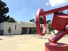 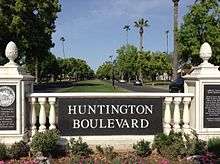  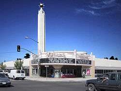 .jpg) Clockwise from top: Downtown Fresno skyline, Huntington Boulevard, Tower Theatre, Bulldog Stadium at night, Woodward Park, Fresno Art Museum | |||
| |||
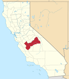
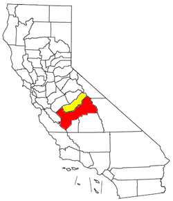
 Location of Fresno in Fresno County, California. | |||
 Fresno, California Location in the United States | |||
| Coordinates: 36°45′N 119°46′W / 36.750°N 119.767°WCoordinates: 36°45′N 119°46′W / 36.750°N 119.767°W | |||
| Country |
| ||
| State |
| ||
| County |
| ||
| Region | San Joaquin Valley | ||
| Railway station | 1872 | ||
| Incorporated | October 12, 1885[1] | ||
| Named for | Spanish for "ash tree" | ||
| Government | |||
| • Type | Mayor-Council | ||
| • Mayor | Lee Brand[2] | ||
| • City manager | Wilma Quan-Schecter[3] | ||
| • City council[4] |
Esmeralda Soria Steve Brandau Oliver Baines III Paul Caprioglio Luis Chavez Garry Bredefeld Clint Olivier | ||
| Area[5] | |||
| • City | 114.70 sq mi (297.07 km2) | ||
| • Land | 114.42 sq mi (296.34 km2) | ||
| • Water | 0.28 sq mi (0.73 km2) 0.31% | ||
| Elevation[6] | 308 ft (94 m) | ||
| Population (2010)[7] | |||
| • City | 494,665 | ||
| • Estimate (2017)[8] | 527,438 | ||
| • Rank |
1st in Fresno County 5th in California 34th in the United States | ||
| • Density | 4,562.76/sq mi (1,761.69/km2) | ||
| • Metro[9] | 972,297 | ||
| Demonym(s) | Fresnan | ||
| Time zone | UTC−8 (Pacific) | ||
| • Summer (DST) | UTC−7 (PDT) | ||
| ZIP codes[10] | 93650, 93701–93712, 93714–93718, 93720–93730, 93737, 93740, 93741, 93744, 93745, 93747, 93750, 93755, 93760, 93761, 93764, 93765, 93771–79, 93786, 93790–94, 93844, 93888 | ||
| Area code | 559 | ||
| FIPS code | 06-27000[11] | ||
| GNIS feature IDs | 277606, 2410546 | ||
| Website |
www | ||
Fresno (/ˈfrɛznoʊ/ FREZ-noh; Spanish for "ash tree") is a city in California, United States, and the county seat of Fresno County. It covers about 112 square miles (290 km2)[12] in the center of the San Joaquin Valley, the southern portion of California's Central Valley.
Named for the abundant ash trees lining the San Joaquin River, Fresno was founded in 1872 as a railway station of the Central Pacific Railroad before it was incorporated in 1885. The city has since become an economic hub of Fresno County and the San Joaquin Valley, with much of the surrounding areas in the Metropolitan Fresno region predominantly tied to large-scale agricultural production.
The population of Fresno grew from a 1960 census population of 134,000 to a 2000 census population of 428,000.[13] With a census-estimated 2017 population of 527,438,[8] Fresno is the fifth-most populous city in California, the most populous city in the Central Valley, the most populous inland city in California, and the 34th-most populous city in the nation.
Fresno is near the geographical center of California. It lies approximately 220 miles (350 km) north of Los Angeles, 170 miles (270 km) south of the state capital, Sacramento, and 185 miles (300 km) southeast of San Francisco. Yosemite National Park is about 60 miles (100 km) to the north, Kings Canyon National Park is 60 miles (100 km) to the east, and Sequoia National Park is 75 miles (120 km) to the southeast.
History
The original inhabitants of the San Joaquin Valley region were the Yokuts people and Miwok people, who engaged in trading with other Californian tribes of Native Americans including coastal peoples such as the Chumash of the Central California coast, with whom they are thought to have traded plant and animal products.
The first European to enter the San Joaquin Valley was Pedro Fages in 1772.[14] The county of Fresno was formed in 1856 after the California Gold Rush. It was named for the abundant ash trees (Spanish: fresno) lining the San Joaquin River. The county was much larger than it is today as part of Tulare County, comprising its current area plus all of what became Madera County and parts of what are now San Benito, Kings, Inyo, and Mono counties.
Millerton, then on the banks of the free-flowing San Joaquin River and close to Fort Miller, became the county seat after becoming a focal point for settlers. Other early county settlements included Firebaugh's Ferry, Scottsburg and Elkhorn Springs.
The San Joaquin River flooded on December 24, 1867, inundating Millerton. Some residents rebuilt, others moved. Flooding also destroyed the town of Scottsburg on the nearby Kings River that winter. Rebuilt on higher ground, Scottsburg was renamed Centerville.[15]
In 1867, Anthony "McQeen" Easterby purchased land bounded by the present Chestnut, Belmont, Clovis and California avenues, that today is called the Sunnyside district. Unable to grow wheat for lack of water, he hired sheep man Moses J. Church in 1871 to create an irrigation system. Building new canals and purchasing existing ditches, Church then formed the Fresno Canal and Irrigation Company, a predecessor of the Fresno Irrigation District.
In 1872, the Central Pacific Railroad established a station near Easterby's—by now a hugely productive wheat farm—for its new Southern Pacific line. Soon there was a store around the station and the store grew into the town of Fresno Station, later called Fresno. Many Millerton residents, drawn by the convenience of the railroad and worried about flooding, moved to the new community. Fresno became an incorporated city in 1885. By 1931 the Fresno Traction Company operated 47 streetcars over 49 miles of track.[16]
In 1877, William Helm made Fresno his home with a five-acre tract of land at the corner of Fresno and R streets. Helm was the largest individual sheep grower in Fresno County. In carrying his wool to market at Stockton, he used three wagons, each drawn by ten mules, and spent twelve days in making the round trip.[17]

Two years after the station was established, county residents voted to move the county seat from Millerton to Fresno. When the Friant Dam was completed in 1944, the site of Millerton became inundated by the waters of Millerton Lake. In extreme droughts, when the reservoir shrinks, ruins of the original county seat can still be observed.
In the nineteenth century, with so much wooden construction and in the absence of sophisticated firefighting resources, fires often ravaged American frontier towns. The greatest of Fresno's early-day fires, in 1882, destroyed an entire block of the city. Another devastating blaze struck in 1883.
In 1909, Fresno's first and oldest synagogue, Temple Beth Israel, was founded.
Fresno entered the ranks of the 100 most populous cities in the United States in 1960 with a population of 134,000. Thirty years later, in the 1990 census, it moved up to 47th place with 354,000, and in the census of 2000, it achieved 37th place with 428,000.[18]
The Fresno Municipal Sanitary Landfill was the first modern landfill in the United States, and incorporated several important innovations to waste disposal, including trenching, compacting, and the daily covering of trash with dirt. It was opened in 1937 and closed in 1987. Today, it has the unusual distinction of being a National Historic Landmark as well as a Superfund site.[19]
Before World War II, Fresno had many ethnic neighborhoods, including Little Armenia, German Town, Little Italy, and Chinatown. In 1940, the Census Bureau reported Fresno's population as 94.0% white, 3.3% black and 2.7% Asian.[20] (Incongruously, Chinatown was primarily a Japanese neighborhood and today Japanese-American businesses still remain). During 1942, Pinedale, in what is now North Fresno, was the site of the Pinedale Assembly Center, an interim facility for the relocation of Fresno area Japanese Americans to internment camps.[21] The Fresno Fairgrounds were also utilized as an assembly center.
Row crops and orchards gave way to urban development particularly in the period after World War II; this transition was particularly vividly demonstrated in locations such as the Blackstone Avenue corridor.
In September 1958, Bank of America launched a new product called BankAmericard in Fresno. After a troubled gestation during which its creator resigned, BankAmericard went on to become the first successful credit card; that is, a financial instrument that was usable across a large number of merchants and also allowed cardholders to revolve a balance (earlier financial products could do one or the other but not both). In 1976, BankAmericard was renamed and spun off into a separate company known today as Visa Inc.
The dance style commonly known as popping evolved in Fresno in the 1970s.[22]
In the 1970s, the city was the subject of a song, "Walking Into Fresno", written by Hall Of Fame guitarist Bill Aken and recorded by Bob Gallion of the world-famous "WWVA Jamboree" radio and television show in Wheeling, West Virginia. Aken, adopted by Mexican-American movie actress Lupe Mayorga, grew up in the neighboring town of Madera and his song chronicled the hardships faced by the migrant farm workers he saw as a child. Aken also made his first TV appearance playing guitar on the old country-western show at The Fresno Barn.
Fictional residents of the town were portrayed in a 1986 comedic miniseries titled "Fresno", featuring Carol Burnett, Dabney Coleman, Teri Garr and Charles Grodin, along with numerous other celebrities. The mini series was presented as a parody of the prime time soap operas popular in the 1980s.
In 1995, the Federal Bureau of Investigation's Operation Rezone sting resulted in several prominent Fresno and Clovis politicians being charged in connection with taking bribes in return for rezoning farmland for housing developments. Before the sting brought a halt to it, housing developers could buy farmland cheaply, pay off council members to have it rezoned, and make a large profit building and selling inexpensive housing. Sixteen people were eventually convicted as a result of the sting.[23]
Geography
Fresno is at 36°44′52″N 119°46′21″W / 36.74778°N 119.77250°W.[24] having a total area of 112.3 square miles (291 km2) with 99.69% land covering 112.0 square miles (290 km2), and 0.31% water, 0.4 square miles (1.0 km2).
Fresno's location, very near the geographical center of California, places the city a comfortable distance from several of the major recreation areas and urban centers in the state. Just 60 mi (97 km) south of Yosemite National Park, it is the nearest major city to the park. Likewise, Sierra National Forest is 40 mi (64 km), Kings Canyon National Park is 60 mi (97 km) and Sequoia National Park is 75 mi (121 km). The city is located near some beautiful Sierra Nevada lakes including Bass Lake, Shaver Lake, and Huntington Lake. Fresno is also only two and a half hours from Monterey, Carmel, Big Sur and the central coast.
Because Fresno sits at the junction of Highways 41 and 99 (41 is Yosemite National Park's southern access road, and 99 branches east from Interstate 5 to serve the urban centers of the San Joaquin Valley), the city is a major gateway for Yosemite visitors coming from Los Angeles. The city also serves as an entrance into Sierra National Forest via highway 168, and Sequoia and Kings Canyon National Parks via Highway 180.
Fresno has three large public parks, two in the city limits and one in county land to the southwest. Woodward Park, which features the Shinzen Japanese Gardens, numerous picnic areas and several miles of trails, is in North Fresno and is adjacent to the San Joaquin River Parkway. Roeding Park, near Downtown Fresno, is home to the Fresno Chaffee Zoo, and Rotary Storyland and Playland. Kearney Park is the largest of the Fresno region's park system and is home to historic Kearney Mansion and plays host to the annual Civil War Revisited, the largest reenactment of the Civil War in the west coast of the U.S.[25][26]
In its 2013 ParkScore ranking, The Trust for Public Land, a national land conservation organization, reported that Fresno had the worst park system among the 50 most populous U.S. cities.[27] The survey measures median park size, park acres as percent of city area, residents' access to parks, spending on parks per resident, and playgrounds per 10,000 residents.
Neighborhoods
Downtown
Fresno was born with the establishment of the then Central Pacific Railroad Depot in 1872. In 1889 Southern Pacific Railroad, which had acquired Central Pacific, constructed a new depot on the original depot site. The brick Queen Anne style depot was a jewel for the city and is currently one of Fresno's oldest standing buildings. In 1971, 99 years after it first opened for business on its current site, the Depot closed its rail operations due to the decline in business.[28]
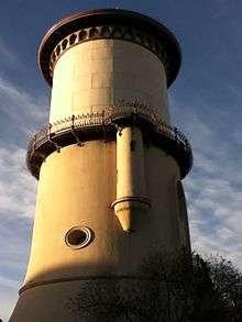
Between the 1880s and World War II, Downtown Fresno flourished, filled with electric Street Cars,[29] and contained some of the San Joaquin Valley's most beautiful architectural buildings.[30] Among them, the original Fresno County Courthouse (demolished), the Fresno Carnegie Public Library (demolished), the Fresno Water Tower, the Bank of Italy Building, the Pacific Southwest Building, the San Joaquin Light and Power Building (currently known as the Grand 1401), and the Hughes Hotel (burned down), to name a few.
Fulton Street in Downtown Fresno was Fresno's main financial and commercial district before being converted into one of the nation's first pedestrian malls in 1964.[31] Renamed the Fulton Mall, the area contains the densest collection of historic buildings in Fresno. While the Fulton Mall corridor has suffered a sharp decline from its heyday, the Mall includes some of the finest public art pieces in the country, including a casting of Pierre-Auguste Renoir's bronze "The Washer Woman", reportedly the only one of the six castings that one can walk up to and touch. Current plans call for the reopening of the Fulton Mall to automobile traffic. The public art pieces will be restored and placed near their current locations and will feature wide sidewalks (up to 28' on the east side of the street) to continue with the pedestrian friendly environment of the district.[32]
Sunnyside
The neighborhood of Sunnyside is on Fresno's far southeast side, bounded by Chestnut Avenue to the West. Its major thoroughfares are Kings Canyon Avenue and Clovis Avenue. Although parts of Sunnyside are within the City of Fresno, much of the neighborhood is a "county island" within Fresno County. Largely developed in the 1950s through the 1970s, it has recently experienced a surge in new home construction. It is also the home of the Sunnyside Country Club, which maintains a golf course designed by William P. Bell.
Tower District

The popular neighborhood known as the Tower District is centered around the historic Tower Theatre, which is included on the National List of Historic Places.[33] The theater was built in 1939 and is at Olive and Wishon Avenues in the heart of the Tower District. (The name of the theater refers to a well-known landmark water tower, which is actually in another nearby area). The Tower District neighborhood is just north of downtown Fresno proper, and one-half mile south of Fresno City College.[34] Although the neighborhood was previously known as a residential area, the early commercial establishments of the Tower District began with small shops and services that flocked to the area shortly after World War II. The character of small local businesses largely remains today. To some extent, the businesses of the Tower District were developed due to the proximity of the original Fresno Normal School, (later renamed California State University at Fresno). In 1916 the college moved to what is now the site of Fresno City College one-half mile north[35] of the Tower District.
This vibrant and culturally diverse area of retail businesses and residences experienced a renewal after a significant decline in the late 1960s and 1970s. After decades of neglect and suburban flight, the neighborhood revival followed the re-opening of the Tower Theatre in the late 1970s, which at that time showed second and third run movies, along with classic films. Roger Rocka's Dinner Theater & Good Company Players also opened nearby in 1978,[36] at Olive and Wishon Avenues. Fresno native Audra McDonald performed in the leading roles of Evita and The Wiz at the theater while she was a high school student. McDonald subsequently became a leading performer on Broadway in New York City and a Tony award-winning actress. Also in the Tower District is Good Company Players' 2nd Space Theatre.
The Tower District is a hub for community events such as Jamaica My Weekend, Mardi Gras in February, Gay Pride Parade, car shows, A Taste of The Tower, Halloween in the Tower, and the Farmer's Market opened on the North-West Corner of Olive and Van Ness.
The neighborhood features restaurants, live theater and nightclubs, as well as several independent shops and bookstores, currently operating on or near Olive Avenue, and all within a few hundred feet of each other. Since renewal, the Tower District has become an attractive area for restaurant and other local businesses. Today, the Tower District is also known as the center of Fresno's LGBT and hipster Communities.;[37] Additionally, Tower District is also known as the center of Fresno's local punk/goth/deathrock and heavy metal community.
The area is also known for its early twentieth century homes, many of which have been restored in recent decades. The area includes many California Bungalow and American Craftsman style homes, Spanish Colonial Revival Style architecture, Mediterranean Revival Style architecture, Mission Revival Style architecture, and many Storybook houses designed by Fresno architects, Hilliard, Taylor & Wheeler. The residential architecture of the Tower District contrasts with the newer areas of tract homes urban sprawl in north and east areas of Fresno.
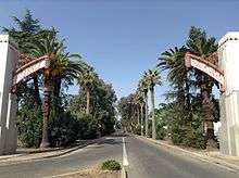
Huntington Boulevard
Homes from the early 20th century line this boulevard in the heart of the historic Alta Vista Tract. The section of Huntington Boulevard between First Street on the west to Cedar Avenue on the east is the home to many large, stately homes. The original development of this area began circa 1910, on 190 acres of what had been an alfalfa field. The Alta Vista Tract, as the land would become known, was mapped by William Stranahan for the Pacific Improvement Corporation, and was officially platted in 1911. The tract's boundaries were Balch Avenue on the south, Cedar Avenue on the east, the rear property line of Platt Avenue (east of Sixth Street) and Platt Avenue (west of Sixth Street) on the north, and First Street on the west. The subdivision was annexed to the city in January 1912, in an election that was the first in which women voted in the community. At the time of its admission to the city, the Alta Vista Tract was uninhabited but landscaped, although the trees had to be watered by tank wagon. In 1914 developers Billings & Meyering acquired the tract, completed street development, provided the last of the necessary municipal improvements including water service, and began marketing the property with fervor. A mere half decade later the tract had 267 homes. This rapid development was no doubt hastened by the Fresno Traction Company right-of-way along Huntington Boulevard, which provided streetcar connections between downtown and the County Hospital.
The surrounding streets, Kerckhoff and Balch Avenues (which are part of the original Alta Vista tract), have homes from the Arts and Crafts era, which, like the downtown, are being renovated and brought back to their historic roots. During Christmas, the homes along the boulevard are adorned with lights and decorations. The nation's tallest living Christmas Tree, at Huntington and 6th Street, is the highlight of the event.
Huntington Boulevard has been referred to as Fresno's "anti-gated community".[38]
Van Ness Extension
North of Shaw Avenue, Van Ness continues as the Van Ness Extension, between Marks Avenue and West Avenue. Van Ness Extension is considered the most prestigious neighborhood in the city, and boasts some of Fresno's most elaborate homes and most affluent citizens. Residents include many notable doctors, business owners, entrepreneurs, and stock traders.
West Side
The "West Side" of Fresno, also often called "Southwest Fresno", is one of the oldest neighborhoods in the city. The neighborhood lies southwest of the 99 freeway (which divides it from Downtown Fresno), west of the 41 freeway and south of Nielsen Ave (or the newly constructed 180 Freeway), and extends to the city limits to the west and south. The neighborhood is traditionally considered to be the center of Fresno's African-American community. It is culturally diverse and also includes significant Mexican-American and Asian-American (principally Hmong or Laotian) populations.
The neighborhood includes Kearney Boulevard, named after early 20th century entrepreneur and millionaire M. Theo Kearney, which extends from Fresno Street in Southwest Fresno about 20 mi (32 km) west to Kerman, California. A small, two-lane rural road for most of its length, Kearney Boulevard is lined with tall palm trees. The roughly half-mile stretch of Kearney Boulevard between Fresno Street and Thorne Ave was at one time the preferred neighborhood for Fresno's elite African-American families. Another section, Brookhaven, on the southern edge of the West Side south of Jensen and west of Elm, was given the name by the Fresno City Council in an effort to revitalize the neighborhood's image. The isolated subdivision was for years known as the "Dogg Pound" in reference to a local gang, and as of late 2008 was still known for high levels of violent crime.
While many homes in the neighborhood date back to the 1930s or before, the neighborhood is also home to several public housing developments built between the 1960s and 1990s by the Fresno Housing Authority. The US Department of Housing and Urban Development has also built small subdivisions of single-family homes in the area for purchase by low-income working families. There have been numerous attempts to revitalize the neighborhood, including the construction of a modern shopping center on the corner of Fresno and B streets, an aborted attempt to build luxury homes and a golf course on the western edge of the neighborhood, and some new section 8 apartments have been built along Church Ave west of Elm St. Cargill Meat Solutions and Foster Farms both have large processing facilities in the neighborhood, and the stench from these (and other small industrial facilities) has long plagued area residents. The Fresno Chandler Executive Airport is also on the West Side. Due to its position on the edge of the city and years of neglect by developers, it is not a true "inner-city" neighborhood, and there are many vacant lots, strawberry fields and vineyards throughout the neighborhood. The neighborhood has very little retail activity, aside from the area near Fresno Street and State Route 99 Freeway (Kearney Palm Shopping Center, built in the late 1990s) and small corner markets scattered throughout.
Woodward Park
In the north eastern part of Fresno, Woodward Park was founded by the late Ralph Woodward, a long-time Fresno resident. He bequeathed a major portion of his estate in 1968 to provide a regional park and bird sanctuary in Northeast Fresno. The park lies on the South bank of the San Joaquin River between Highway 41 and Friant Road. The initial 235 acres (0.95 km2), combined with additional acres acquired later by the city, brings the park to a sizable 300 acres (1.2 km2).[39] Now packed with amenities, Woodward Park is the only Regional Park of its size in the Central Valley. The Southeast corner of the park harbors numerous bird species offering bird enthusiasts an excellent opportunity for viewing. The park has a multi-use amphitheatre that seats up to 2,500 people, authentic Japanese Garden, fenced dog park, two-mile (3 km) equestrian trail, exercise par course, three children's playgrounds, a lake, 3 small ponds, 7 picnic areas and five miles (8 km) of multipurpose trails that are part of the San Joaquin River Parkway's Lewis S. Eaton Trail. When complete, the Lewis S. Eaton trail system will cover 22 miles (35 km) between Highway 99 and Friant Dam. The park's numerous picnic tables make for a great picnic destination and a convenient escape from city life. The park's amphetheatre was renovated in 2010, and has hosted performances by acts such as Deftones, Tech N9ne, and Sevendust as well as numerous others. The park is open April through October, 6am to 10pm and November through March, 6am to 7pm. Woodward Park is home to the annual CIF (California Interscholastic Federation) State Championship cross country meet, which takes place in late November. It is also the home of the Woodward Shakespeare Festival which began performances in the park in 2005.[40]
Sierra Sky Park
Formed in 1946, Sierra Sky Park Airport is a residential airport community born of a unique agreement in transportation law to allow personal aircraft and automobiles to share certain roads. Sierra Sky Park was the first aviation community to be built and there are now numerous such communities across the United States and around the world. Developer William Smilie created the nation's first planned aviation community. Still in operation today, the public use airport provides a unique neighborhood that spawned interest and similar communities nationwide.
Climate
Fresno is marked by a semi-arid climate (Köppen BSk/BSh), with mild, moist winters and very hot, dry summers, thus displaying Mediterranean characteristics.[41] December and January are the coldest months, and average around 46.5 °F (8.1 °C), and there are 14 nights with freezing lows annually, with the coldest night of the year typically bottoming out around 30 °F (−1.1 °C).[42] July is the warmest month, averaging 83.0 °F (28.3 °C); normally, there are 32 days of 100 °F (37.8 °C)+ highs and 106 days of 90 °F (32.2 °C)+ highs, and in July and August, there are only three or four days where the high does not reach 90 °F (32.2 °C). Summers provide considerable sunshine, with July exceeding 96 percent of the total possible sunlight hours; conversely, January is the lowest with only 46 percent of the daylight time in sunlight because of tule fog. However, the year averages 81% of possible sunshine, for a total of 3550 hours.[43] Average annual precipitation is around 11.5 inches (292.1 mm), which, by definition, would classify the area as a semidesert. Most of the wind rose direction occurrences derive from the northwest, as winds are driven downward along the axis of the California Central Valley; in December, January and February there is an increased presence of southeastern wind directions in the wind rose statistics.[44] Fresno meteorology was selected in a national U.S. Environmental Protection Agency study for analysis of equilibrium temperature for use of ten-year meteorological data to represent a warm, dry western United States locale.[45]
| Climate data for Fresno, California (Fresno Airport), 1981–2010 normals, extremes 1881–present[lower-alpha 1] | |||||||||||||
|---|---|---|---|---|---|---|---|---|---|---|---|---|---|
| Month | Jan | Feb | Mar | Apr | May | Jun | Jul | Aug | Sep | Oct | Nov | Dec | Year |
| Record high °F (°C) | 78 (26) |
84 (29) |
90 (32) |
101 (38) |
110 (43) |
112 (44) |
115 (46) |
113 (45) |
111 (44) |
102 (39) |
90 (32) |
77 (25) |
115 (46) |
| Average high °F (°C) | 54.8 (12.7) |
61.6 (16.4) |
67.6 (19.8) |
74.6 (23.7) |
84.1 (28.9) |
92.0 (33.3) |
98.4 (36.9) |
97.1 (36.2) |
90.9 (32.7) |
79.5 (26.4) |
65.1 (18.4) |
54.9 (12.7) |
76.7 (24.8) |
| Average low °F (°C) | 38.3 (3.5) |
41.5 (5.3) |
45.6 (7.6) |
49.4 (9.7) |
56.2 (13.4) |
62.4 (16.9) |
67.6 (19.8) |
66.2 (19) |
61.5 (16.4) |
53.0 (11.7) |
43.4 (6.3) |
38.0 (3.3) |
51.9 (11.1) |
| Record low °F (°C) | 17 (−8) |
24 (−4) |
26 (−3) |
32 (0) |
36 (2) |
42 (6) |
50 (10) |
49 (9) |
37 (3) |
27 (−3) |
26 (−3) |
18 (−8) |
17 (−8) |
| Average precipitation inches (mm) | 2.19 (55.6) |
2.03 (51.6) |
2.03 (51.6) |
0.95 (24.1) |
0.43 (10.9) |
0.21 (5.3) |
0.01 (0.3) |
0.01 (0.3) |
0.17 (4.3) |
0.63 (16) |
1.07 (27.2) |
1.77 (45) |
11.50 (292.1) |
| Average precipitation days (≥ 0.01 in) | 7.6 | 8.6 | 7.5 | 4.5 | 2.2 | 0.7 | 0.2 | 0.3 | 1.0 | 2.5 | 5.5 | 7.5 | 48.1 |
| Average relative humidity (%) | 83.3 | 77.2 | 68.9 | 57.4 | 47.3 | 41.9 | 39.2 | 44.7 | 50.0 | 58.5 | 74.1 | 84.2 | 60.6 |
| Mean monthly sunshine hours | 141.5 | 196.9 | 286.2 | 335.5 | 398.9 | 412.2 | 428.2 | 399.6 | 345.9 | 302.3 | 189.9 | 127.1 | 3,564.2 |
| Percent possible sunshine | 46 | 65 | 77 | 85 | 91 | 94 | 96 | 95 | 93 | 87 | 62 | 42 | 80 |
| Source: NOAA (relative humidity and sun 1961–1990)[46][47][48], Weather.com[49] | |||||||||||||
The official record high temperature for Fresno is 115 °F (46.1 °C), set on July 8, 1905, while the official record low is 17 °F (−8 °C), set on January 6, 1913.[50] The average windows for temperatures to exceed 100 °F (37.8 °C) are June 1 through September 13; for temperatures in excess of 90 °F (32.2 °C), April 26 through October 9; and for freezing temperatures, December 10 through January 28, although no freeze occurred during the 1983/1984 winter season.[50] Annual rainfall has ranged from 23.57 inches (598.7 mm) in the "rain year" from July 1982 to June 1983 down to 4.43 inches (112.5 mm) from July 1933 to June 1934. The most rainfall in one month was 9.54 inches (242.3 mm) in November 1885 and the most rainfall in 24 hours 3.55 inches (90.2 mm) on November 18, 1885. Measurable precipitation falls on an average of 48 days annually. Snow is a rarity; the heaviest snowfall at the airport was 2.2 inches (0.06 m) on January 21, 1962.[51]
Demographics
| Historical population | |||
|---|---|---|---|
| Census | Pop. | %± | |
| 1880 | 1,112 | — | |
| 1890 | 10,818 | 872.8% | |
| 1900 | 12,470 | 15.3% | |
| 1910 | 24,892 | 99.6% | |
| 1920 | 45,086 | 81.1% | |
| 1930 | 52,513 | 16.5% | |
| 1940 | 60,685 | 15.6% | |
| 1950 | 91,669 | 51.1% | |
| 1960 | 133,929 | 46.1% | |
| 1970 | 165,655 | 23.7% | |
| 1980 | 217,491 | 31.3% | |
| 1990 | 354,202 | 62.9% | |
| 2000 | 427,652 | 20.7% | |
| 2010 | 494,665 | 15.7% | |
| Est. 2017 | 527,438 | [8] | 6.6% |
| U.S. Decennial Census[52] | |||
| Racial composition | 2010[53] | 1990[20] | 1970[20] | 1940[20] |
|---|---|---|---|---|
| White | 50.6% | 59.2% | 86.7% | 94.0% |
| —Non-Hispanic | 30.0% | 49.4% | 72.6%[54] | n/a |
| Black or African American | 8.3% | 8.3% | 9.6% | 3.3% |
| Hispanic or Latino (of any race) | 46.9% | 29.9% | 16.1%[54] | n/a |
| Asian | 12.6% | 12.5% | 2.0% | 2.7% |
Fresno is the larger principal city of the Fresno-Madera CSA, a Combined Statistical Area that includes the Fresno (Fresno County) and Madera (Madera County) metropolitan areas,[55][56] which had a combined population of 922,516 at the 2000 census.[11]
2010
The 2010 United States Census[57] reported that Fresno had a population of 494,665. The population density was 4,404.5 people per square mile (1,700.6/km²). The racial makeup of Fresno was 245,306 (49.6%) White, 40,960 (8.3%) African American, 8,525 (1.7%) Native American, 62,528 (12.6%) Asian (3.6% Hmong, 1.7% Indian, 1.2% Filipino, 1.2% Laotian, 1.0% Thai, 0.8% Cambodian, 0.7% Chinese, 0.5% Japanese, 0.4% Vietnamese, 0.2% Korean), 849 (0.2%) Pacific Islander, 111,984 (22.6%) from other races, and 24,513 (5.0%) from two or more races. Hispanic or Latino of any race were 232,055 persons (46.9%). Among the Hispanic population, 42.7% of the total population are Mexican, 0.4% Salvadoran, and 0.4% Puerto Rican. Non-Hispanic Whites were 30.0% of the population in 2010,[53] down from 72.6% in 1970.[20]
.png)
The Census reported that 485,798 people (98.2% of the population) lived in households, 4,315 (0.9%) lived in non-institutionalized group quarters, and 4,552 (0.9%) were institutionalized.
There were 158,349 households, of which 68,511 (43.3%) had children under the age of 18 living in them, 69,284 (43.8%) were opposite-sex married couples living together, 30,547 (19.3%) had a female householder with no husband present, 11,698 (7.4%) had a male householder with no wife present. There were 12,843 (8.1%) unmarried opposite-sex partnerships, and 1,388 (0.9%) same-sex married couples or partnerships. 35,064 households (22.1%) were made up of individuals and 12,344 (7.8%) had someone living alone who was 65 years of age or older. The average household size was 3.07. There were 111,529 families (70.4% of all households); the average family size was 3.62.
The age distribution of the population shows 148,823 people (30.1%) under the age of 18, 62,601 people (12.7%) aged 18 to 24, 135,076 people (27.3%) aged 25 to 44, 102,064 people (20.6%) aged 45 to 64, and 46,101 people (9.3%) who were 65 years of age or older. The median age was 29.3 years. For every 100 females, there were 96.7 males. For every 100 females age 18 and over, there were 93.5 males.
There were 171,288 housing units at an average density of 1,525.2 per square mile (588.9/km²), of which 158,349 were occupied, of which 77,757 (49.1%) were owner-occupied, and 80,592 (50.9%) were occupied by renters. The homeowner vacancy rate was 2.6%; the rental vacancy rate was 7.6%. 235,430 people (47.6% of the population) lived in owner-occupied housing units and 250,368 people (50.6%) lived in rental housing units.
2000
As of the census[11] of 2000, there were 427,652 people, 140,079 households, and 97,915 families residing in the city. The population density was 4,097.9 people per square mile (1,582.2/km²). There were 149,025 housing units at an average density of 1,427.9 square miles (3,698 km2). The racial makeup of the city was 50.2% White, 8.4% Black or African American, 1.6% Native American, 11.2% Asian (about a third of which is Hmong), 0.1% Pacific Islander, 23.4% from other races, and 5.2% from two or more races. Hispanic or Latino of any race were 39.9% of the population.
There were 140,079 households of which 40.4% had children under the age of 18 living with them, 46.1% were married couples living together, 17.6% had a female householder with no husband present, and 30.1% were non-families. 23.3% of all households were made up of individuals and 7.9% had someone living alone who was 65 years of age or older. The average household size was 2.99 and the average family size was 3.57.
In the city, the age distribution of the population shows 32.9% under the age of 18, 11.8% from 18 to 24, 28.8% from 25 to 44, 17.2% from 45 to 64, and 9.3% who were 65 years of age or older. The median age was 28 years. For every 100 females, there were 96.6 males. For every 100 females age 18 and over, there were 93.0 males.
The median income for a household in the city was $32,236, and the median income for a family was $35,892. Males had a median income of $32,279 versus $26,551 for females. The per capita income for the city was $15,010. About 20.5% of families and 26.2% of the population were below the poverty line, including 36.5% of those under age 18 and 10.7% of those age 65 or over.
The population as of July 1, 2007 was estimated to be 470,508 by the US Census Bureau's Population Estimates Program.[58] The Fresno Metropolitan Statistical Area population was estimated at 899,348.[59]
Hmong population
The Fresno Hmong community, along with that of Minneapolis/St. Paul, is one of the largest two urban U.S. Hmong communities.[60]
Economy
Fresno serves as the economic hub of Fresno County and California's San Joaquin Valley. The unincorporated area and rural cities surrounding Fresno remain predominantly tied to large-scale agricultural production.
In 1958, Fresno was selected by Bank of America to first launch the BankAmericard credit card, which was later renamed Visa.
Companies based in Fresno include Valley Yellow Pages, Zacky Farms, California Ag Today Media and Saladino's.
According to the City's 2015 Comprehensive Annual Financial Report,[61] the top employers in the city are:
| # | Employer | # of Employees |
|---|---|---|
| 1 | Community Medical Centers | 4,789 |
| 2 | City of Fresno | 2,938 |
| 3 | Saint Agnes Medical Center | 2,400 |
| 4 | Kaiser Permanente | 2,000 |
| 5 | California State University, Fresno | 1,562 |
| 6 | State Center Community College District | 1,178 |
| 7 | Cargill Meat Solutions Corporation | 1,150 |
| 8 | Fresno Economic Opportunities Commission | 973 |
| 9 | AmeriGuard Security Services | 567 |
| 10 | Guarantee Real Estate | 544 |
| 11 | Geil Enterprises, Inc. | 500 |
Culture
Performing arts and music
- Artists' Repertory Theatre
- Children's Musical Theatreworks
- Center State Productions
- Fresno Grand Opera
- Fresno Philharmonic
- Roger Rocka's Dinner Theater & 2nd Space Theatre (Good Company Players)
- Youth Orchestras of Fresno
- Rogue Festival
- Woodward Shakespeare Festival
Historic theaters
- Azteca Theater
- Crest Theatre
- Liberty Theatre – currently Victory Church
- Tower Theatre – Tower Theatre for the Performing Arts
- Warnors Theatre – Warnor's Center for the Performing Arts
- Wilson Theatre – currently Cornerstone Church
- Veteran's Memorial Auditorium
- Hardy's Theatre
- Country Squire Theatre 1st & Ashlan
- Fig Garden Cinema
Museums and other attractions
- African-American Museum of the San Joaquin Valley
- Arte Américas
- Armenian Museum of Fresno
- Discovery Center
- Forestiere Underground Gardens
- Fresno Art Museum
- Kearney Mansion Museum
- Legion of Valor Museum
- Meux Home Museum
- Old Fresno Water Tower Tourist Center
- Fresno Chaffee Zoo
- Sierra Endangered Cat Haven (Fresno County)
Regular events

- Armenian Grape Blessing (August)[62]
- ArtHop (twice a month)[63]
- The Big Fresno Fair, 12 days October, the largest event in the Central Valley attracting over 600,000 visitors[64]
- Taco Truck Throwdown[65]
- Cinco de Mayo at Fulton Mall
- Christmas Tree Lane Every December[66][67]
- Fiestas Patrias at Fulton Mall Usually in September
- Fresno County Blossom Trail Late February to April
- Fresno Film Festival November
- Fresno LGBT Pride Parade, every June, first held in 1991[68]
- Fresno Greek Fest Late August
- Grizzly Fest April/May[69]
- Fresno Hmong New Year December 26-January 1
- Fresno Maker Month April
- Miss California Pageant Usually in June
- Reel Pride Gay & Lesbian Film Festival September
- Rogue Festival March
- Sudz in the City October
- Swede Fest November
- Vintage Days March or April
Sports
Fresno has no teams in any of the five major sports leagues: (NFL) football, (MLB) baseball, (NBA) basketball, (NHL) hockey or (MLS) soccer. Below are Fresno-based sports organizations.
| Club | Sport | Founded | League (and level) | Venue |
|---|---|---|---|---|
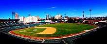
| Fresno Grizzlies | Baseball | 1998 | Pacific Coast League (Triple-A) | Chukchansi Park |
| Fresno FC[70] | Soccer | 2017 | United Soccer League (Division 2) | Chukchansi Park |
| Fresno FC U-23[lower-alpha 2] | Soccer | 2003 | Premier Development League (Division 4) | Fresno State Soccer & Lacrosse Stadium |
| Fresno Monsters | Ice hockey | 2009 | Western States Hockey League (Tier II junior) | Selland Arena |
- The Save Mart Center at Fresno State is a multi-purpose arena on the campus of the California State University, Fresno. It is home to the Fresno State Bulldogs basketball team and, for the first five seasons in the ECHL (2003–08) hosted the Fresno Falcons ice hockey team. It also hosts a wide range of musical acts and other events.
- Also on the campus of Fresno State is Bulldog Stadium, a 41,031 seat football stadium. It is home to the Fresno State Bulldogs football program.
- Next to Bulldog Stadium is Pete Beiden Field. It is home to the Fresno State Bulldogs baseball program and was home to the Fresno Grizzlies before their move to Chukchansi Park in Downtown Fresno.
- Fresno's Woodward Park is the location of the CIF Cross Country State Championships, where high schoolers from around the state compete. Additionally the BMX course in the park plays host to the National Bicycle League State Championships.
- Ratcliffe Stadium, on the campus of Fresno City College, is a 13,000 seat track and field stadium. The stadium played host to the West Coast Relays. It is home to the college's football program and is also host to high school football games and track and field events.
- The Fresno Yacht Club established in 1959 hosts the High Sierra Regatta on Huntington Lake every July (barring extreme drought) and regular sailing on Millerton Lake.[71][72]
Government
Fresno has a modified strong-mayor form of local government and seven City Council members (Legislative branch) elected for no more than two 4-year terms. The City Council and the mayor are nonpartisan, not affiliated with any political party. Alan Autry was first elected in November 2000, reelected on March 2, 2004, and served until January 2009. Ashley Swearengin was sworn in as Mayor on January 6, 2009 and reelected in 2012. Lee Brand was sworn in as Mayor on January 3, 2017.
President, Board of Trustees
Prior to 1901, Fresno was governed by a board of trustees.[73]
- William Faymonville – October 27, 1885 to April 25, 1887
- W.L. Graves – April 25, 1887 to October 31, 1887
- A.M. Clark – October 31, 1887 to April 15, 1889
- A.J. Pedlar – April 15, 1889 to unknown
- C.J. Craycroft – October 27, 1895 to 1901
Mayor
|
|
|
† Died in office
City Council
The Fresno City Council is made up of seven members, elected by district:[4]
- District 1 (west-central) – Esmeralda Soria
- District 2 (northwest) – Steve Brandau
- District 3 (southwest and downtown) – Oliver Baines III
- District 4 (east-central) – Paul Caprioglio
- District 5 (southeast) – Luis Chavez
- District 6 (northeast) – Garry Bredefeld
- District 7 (central) – Clinton Olivier
The City Council meets at Fresno City Hall.
City departments
|
|
|
Courts

Fresno is the county seat of Fresno County. It maintains the main county courthouse on Van Ness in the Fresno County Plaza for criminal and some civil court cases.
The United States District Court, Eastern District of California, has one of its six divisions based in the Robert E. Coyle Courthouse. The new courthouse replaced the B.F. Sisk Federal Building in 2006 because it did not have enough space for the growing Fresno Division. After extensive renovation, the building reopened in November 2010 as the B.F. Sisk Courthouse serving the Fresno County Superior Court.
Fresno is also the seat of the Fifth Appellate District of the State of California Court of Appeal where a new courthouse was built in the old Armenian Town section of downtown Fresno in 2007 across from the Fresno Convention Center. The Fifth District Court of Appeal Courthouse is named after former State Senator and Associate Justice of the Fifth District, George N. Zenovich.
Politics

According to Fresno County Registrar of Voters, the majority of registered voters in both the city and county of Fresno are registered to the Democratic Party. According to the county registrar's official final reportU.S. President Barack Obama carried the county 49.99% in the 2008 United States presidential election.
State and federal representation
The citizens of Fresno are represented in the California State Senate by Republican Andy Vidak in District 14 and Republican Tom Berryhill in District 8.[78] They are represented in the California State Assembly by Republican Jim Patterson in District 23 and Democrat Joaquin Arambula in District 31.[79]
The citizens of Fresno are represented in the United States House of Representatives by Democrat Jim Costa in District 16[80] and Republican Devin Nunes in District 22.[81]
Education
Four-year institutions
California State University, Fresno is the main state school in Fresno though the University of California, Merced has its Fresno Center[83] and the University of California, San Francisco has its Fresno Medical Education Program[84]
Private institutions include
- Alliant International University (For Profit)
- California Christian College (Private/Freewill Baptist)
- Fresno Pacific University (Private/Mennonite Brethren)
- Kaplan College, Fresno campus (formerly Maric College)
- National University, Fresno campus
- University of Phoenix (Private) (For Profit)
- DeVry University (Private) (For Profit, Career)
Two-year institutions
Public community colleges include Fresno City College and Clovis Community College.
Career colleges
Public K-12 schools
Most of Fresno is in the Fresno Unified School District though small portions are served by the Clovis Unified School District, Central Unified School District, Washington Union Unified School district and Orange Center Elementary School District.
Private K-12 schools
- Fresno Christian High School (Evangelical Christian)
- San Joaquin Memorial High School (Roman Catholic)
Fresno Adventist Academy
Media
Newspapers
- The Business Journal
- The Fresno Bee
Magazines
- Fresno Magazine
Radio
- KMJ, AM 580 and FM 105.9, was Fresno's first radio station; it began broadcasting in 1922. Over the years its powerful 50,000-watt signal could clearly be heard throughout much of California.
- KFIG AM 940, 50,000-watt affiliate of ESPN radio and also the flagship station for Fresno State University football and men's basketball
- KYNO AM 1430, 5,000-watt oldies station and flagship for the Pacific Coast League Fresno Grizzlies
- 88.1 KFCF is Fresno's Pacifica station, and one of Fresno's few non-commercial, non-corporate radio stations.
- 89.3 KVPR, provides National Public Radio Programming & classical music throughout the Central California region.
- 90.7 KFSR is another non-commercial, non-corporate station that plays a full spectrum format, including Jazz, eclectic, Armenian, and others. Based on the CSUF campus.
- 94.9 KBOS-FM More commonly known as B95 – Fresno's Hip-Hop Station
Television
To avoid interference with existing VHF television stations in the San Francisco Bay Area and those planned for Chico, Sacramento, Salinas, and Stockton, the Federal Communications Commission decided that Fresno would be a UHF island (only have UHF television stations). The very first Fresno television station to begin broadcasting was KMJ-TV, which debuted on June 1, 1953. KMJ-TV is now known as NBC affiliate KSEE. Other Fresno stations include ABC O&O KFSN-TV, CBS affiliate KGPE, The CW affiliate KFRE-TV, FOX affiliate KMPH-TV, MNTV affiliate KAIL, PBS affiliate KVPT, Telemundo O&O KNSO, Univision O&O KFTV-DT, and Estrella TV affiliate KGMC.
In partnership with the City of Clovis, the City of Fresno opened the Community Media Access Collaborative (CMAC) in April 2012, a public, education and government access television station.
Transportation
Highways
Fresno is served by State Route 99, the main north/south freeway that connects the major population centers of the California Central Valley. State Route 168, the Sierra Freeway, heads east to the city of Clovis and Huntington Lake. State Route 41 (Yosemite Freeway/Eisenhower Freeway) comes into Fresno from Atascadero in the south, and then heads north to Yosemite National Park. State Route 180 (Kings Canyon Freeway) comes from the west via Mendota, and then east through the city of Reedley to Kings Canyon National Park.
Fresno is the largest U.S. city not directly linked to an Interstate highway.[85] When the Interstate Highway System was created in the 1950s, the decision was made to build what is now Interstate 5 on the west side of the Central Valley, and thus bypass many of the population centers in the region, instead of upgrading what is now State Route 99.[86] Due to rapidly rising population and traffic in cities along SR 99, as well as the desirability of Federal funding, much discussion has been made to upgrade it to interstate standards and eventually incorporate it into the interstate system, most likely as Interstate 9. Major improvements to signage, lane width, median separation, vertical clearance, and other concerns are currently underway.
Airports
Fresno Yosemite International Airport (FAT), formerly known as Fresno Air Terminal, provides regularly scheduled commercial airline service. The airport serves an estimated 1.3 million passengers annually.
Fresno Chandler Executive Airport (FCH) is 2 mi (3.2 km) southwest of Downtown Fresno. Built in the 1920s by the Works Projects Administration, it is one of the oldest operational airports in California. The airport currently serves as a general aviation airport.
Sierra Sky Park Airport in Northwest Fresno is a privately owned airport, but is open to the public. The airport was America's first aviation community. Extra-wide streets surrounding the airport allow for residents of the community to land, taxi down extra-wide avenues, and park in the driveway at home.[87]
Rail
Passenger rail service is provided by Amtrak San Joaquins. The main passenger rail station is the recently renovated historic Santa Fe Railroad Depot in Downtown Fresno. The Bakersfield-Stockton mainlines of the Burlington Northern Santa Fe Railway and Union Pacific Railroad railroads cross in Fresno, and both railroads maintain railyards within the city; the San Joaquin Valley Railroad also operates former Southern Pacific branch lines heading west and south out of the city. The city of Fresno is planned to serve the future California High Speed Rail.[88]
Public transportation
Public transit is provided by the Fresno Area Express (FAX). It consists entirely of buses serving the greater Fresno metropolitan area. Intercity and long-distance bus service is provided by Greyhound and Orange Belt Stages. Beginning May 2015, Fresno has also been served by the Yosemite Area Regional Transportation System, with connecting routes available in the Yosemite Valley.[89][90]
The city once provided trolley service during the late 19th and early 20th century. Known as the Fresno City Railway Company and later the Fresno Traction Company, the service operated horse-drawn streetcars from 1887 to 1901. Electric streetcars were introduced in 1903. The electric streetcars were used until 1939.[91]
Notable people
Military units
US Army
Army Maintenance Support Activity 14, 63rd Regional Support Command.
729 Transportation Company, 63rd Regional Support Command.
924 Training Camp Detachment, 63rd Regional Support Command.
All at the US Army Reserve Center at the Fresno Yosemite International Airport.[92]
US Marine Corps
Detachment Alpha, Marine Wing Support Squadron 473, Marine Wing Support Group 47, 4th Marine Aircraft Wing[93]
Formerly at The Fresno Yosemite International Airport. The unit is now based out of Lemoore Naval Air Station in Lemoore, California, about 30 miles outside Fresno.
US Navy
Naval Air Station Lemoore, the Navy's west coast Master Jet Base is 30 miles (48 km) south of downtown Fresno.
US Air Force
No known units.
California Army National Guard
40th Aviation Brigade, 40th Infantry Division.[94] Located at Hammer Army Air Field Armory.
Echo Company, 79th Brigade Support Battalion, 79th Infantry Brigade Combat Team, 40th Infantry Division.
1106th Aviation Classification Repair Depot, 1106th Theater Aviation Maintenance Sustainment Group.[95] Located at the Aviation Classification Repair Depot on the Fresno Yosemite International Airport.
Detachment 1, 649th MP Company, 185th Military Police Battalion, 49th Military Police Brigade. Located at the Army National Guard Armory on the Fresno Fairgrounds.
California Air National Guard
144th Fighter Wing.[95] Located at the Fresno Air National Guard Base at Fresno Yosemite International Airport.
California State Military Reserve
40th Combat Aviation Brigade (CAB).
100th Troop Command Support Brigade.
1st Task Force Civil Support, Regional Support Command – North.[96]
At The Fresno Armed Forces Reserve Center adjacent to Hammer Army Air Field Armory.
Twin towns – sister cities
Fresno has eight sister and friendship cities:[97] The latest in January 2016 is Châteauroux in central France.[98] The others are Afula-Gilboa in Israel since 1973, Etchmiadzin in Armenia since 2009,[99] Kōchi in Japan, Taishan in China, Verona in Italy, Torreón in Mexico, and Münster in Germany.[100]
The Shinzen Friendship Garden in Woodward Park was dedicated in 1981 to honor the relationship with Kōchi.[101]
See also
Notes
- ↑ Official records for Fresno kept September 1881 to 15 August 1887 at downtown, 16 August 1887 to June 1939 at Fresno City Offices, July 1939 to 20 August 1949 at Chandler Field, and at Fresno Yosemite Int'l since 21 August 1949. For more information, see Threadex
- ↑ The Fresno Fuego FC has existed since 2003 but has been acquired by the new Fresno FC and renamed Fresno FC U-23
References
- ↑ "California Cities by Incorporation Date". California Association of Local Agency Formation Commissions. Archived from the original (Word) on November 3, 2014. Retrieved April 6, 2013.
- ↑ "Mayor's Office". City of Fresno. Retrieved April 6, 2013.
- ↑ "City Manager". City of Fresno. Retrieved 15 July 2017.
- 1 2 "Fresno City Council". City of Fresno. City of Fresno. Retrieved 9 July 2017.
- ↑ "2016 U.S. Gazetteer Files". United States Census Bureau. Retrieved Jul 19, 2017.
- ↑ "Fresno". Geographic Names Information System. United States Geological Survey.
- ↑ https://www.census.gov/quickfacts/table/PST045214/0627000
- 1 2 3 "American FactFinder". Retrieved May 26, 2018.
- ↑ "Archived copy". Archived from the original on July 17, 2015. Retrieved 2015-09-26.
- ↑ "ZIP Code(tm) Lookup". United States Postal Service. Retrieved November 23, 2014.
- 1 2 3 "American FactFinder". United States Census Bureau. Archived from the original on September 11, 2013. Retrieved 2008-01-31.
- ↑ "2010 Census U.S. Gazetteer Files – Places – California". United States Census Bureau.
- ↑ "Population of the 100 Largest Cities and Other Urban Places in the United States: 1790 TO 1990". U.S. Census Bureau. Retrieved 2010-07-02.
- ↑ Capace, Nancy (1999). Encyclopedia of California. North American Book Dist LLC. Page 410. ISBN 9780403093182.
- ↑ Durham, David L. (1998). California's Geographic Names: A Gazetteer of Historic and Modern Names of the State. Clovis, Calif.: Word Dancer Press. p. 1014-1015. ISBN 1-884995-14-4.
- ↑ Demoro, Harre W. (1986). California's Electric Railways. Glendale, California: Interurban Press. p. 201. ISBN 0-916374-74-2.
- ↑ History of the State of California and Biographical Record of the San Joaquin Valley, California.
- ↑ "U.S. Census Bureau, Population of the 100 Largest Cities and Other Urban Places in the United States: 1790 TO 1990". Retrieved 2010-07-02.
- ↑ Kevin Enns-Rempel; John Edward Powell. "Fresno Sanitary Landfill (1937)". HistoricFresno.org. Retrieved 2007-04-23.
- 1 2 3 4 5 "California – Race and Hispanic Origin for Selected Cities and Other Places: Earliest Census to 1990". U.S. Census Bureau. Archived from the original on August 6, 2012. Retrieved April 22, 2012.
- ↑ "Pinedale Assembly Center, California". U.S. National Park Service. Archived from the original on April 7, 2007. Retrieved April 23, 2007.
- ↑ Holman, Michael (October 1984). "History". Breaking and the New York City Breakers. Freundlich Books. ISBN 0-88191-016-3. Archived from the original on October 19, 2007. Retrieved May 15, 2007.
- ↑ Jim Boren (December 12, 2002). "Lessons learned from Rezone can't be forgotten". The Fresno Bee. Archived from the original on December 28, 2002. Retrieved 2007-04-23.
- ↑ U.S. Geological Survey Geographic Names Information System: Fresno, California
- ↑ "Civil War Revisited Wraps Up". ABC30.com. October 10, 2005. Retrieved 2007-03-06.
- ↑ "The Civil War Revisited". Fresno Historical Society. Archived from the original on June 10, 2013. Retrieved 2007-03-06.
- ↑ "City Profiles: Fresno". "The Trust for Public Land". Retrieved on 10 July 2013.
- ↑ http://historicfresno.org/nrhp/sprr.htm
- ↑ http://historical.fresnobeehive.com/2010/05/fresno-street-cars/
- ↑ http://historical.fresnobeehive.com/2009/06/mariposa-street/
- ↑ http://historical.fresnobeehive.com/2009/11/before-fulton-mall/
- ↑ http://www.thebusinessjournal.com/news/government-and-politics/17972-fulton-mall-project-to-shift-into-gear-next-month%5Bpermanent+dead+link%5D
- ↑ "building # 92001276 on the national register of historic places". Nationalregisterofhistoricplaces.com. Retrieved 2010-07-02.
- ↑ "Fresno's Historic Tower Theatre". Tower2000.com. Retrieved 2010-07-02.
- ↑ "The Old Administration Building at Fresno City College :: A Legacy Renewed". Oabalegacyrenewed.com. Archived from the original on August 20, 2008. Retrieved 2010-07-02.
- ↑ "Roger Rocka's Dinner Theater | Home of Good Company Players". Retrieved 2016-08-08.
- ↑ The Collegian » Remembering the life of a 'corporate sellout'
- ↑ Archived December 18, 2014, at the Wayback Machine.
- ↑ "Woodward Park". City of Fresno. Retrieved September 9, 2014.
- ↑ Munro, Donald (June 19, 2014). "Woodward Shakespeare Festival turns 10; its revels play on". The Fresno Bee. Archived from the original on September 11, 2014. Retrieved September 9, 2014.
- ↑ "Fresno, California Climate Summary". RSS Feeds World Weather. Retrieved 2007-03-06.
- ↑ The Arbor Day Foundation. Arborday.org. Retrieved on 2013-07-29.
- ↑ "Climatological Normals of Fresno". Hong Kong Observatory. Retrieved 2010-05-13.
- ↑ "Fresno, California Wind Direction Diagram". Causes of Haze Assessment. 2002. Archived from the original on September 12, 2006. Retrieved 2007-03-06.
- ↑ Hogan, C. Michael; Patmore, Leda C.; Harry Seidman (August 1973). "Statistical Prediction of Dynamic Thermal Equilibrium Temperatures using Standard Meteorological Data Bases". EPA-660/2-73-003. U.S. Environmental Protection Agency. Retrieved 2007-03-06.
- ↑ "NowData – NOAA Online Weather Data". National Oceanic and Atmospheric Administration. Retrieved 2012-12-03.
- ↑ "Station Name: CA FRESNO YOSEMITE INTL AP". National Oceanic and Atmospheric Administration. Retrieved 2014-04-22.
- ↑ "WMO Climate Normals for FRESNO/AIR TERMINAL CA 1961–1990". National Oceanic and Atmospheric Administration. Retrieved 2014-03-11.
- ↑ "Average Weather for Fresno, CA – Temperature and Precipitation". The Weather Channel. Retrieved 2011-09-20.
- 1 2 "NowData - NOAA Online Weather Data". National Oceanic and Atmospheric Administration. Retrieved 2012-12-03.
- ↑ "FRESNO WSO AP, CALIFORNIA – Climate Summary". Wrcc.dri.edu. Retrieved 2010-07-02.
- ↑ "Census of Population and Housing". Census.gov. Archived from the original on May 12, 2015. Retrieved June 4, 2015.
- 1 2 "Fresno (city), California". State & County QuickFacts. U.S. Census Bureau. Archived from the original on April 27, 2012. Retrieved April 22, 2012.
- 1 2 From 15% sample
- ↑ Metropolitan Statistical Areas and Components Archived May 26, 2007, at the Wayback Machine., Office of Management and Budget, 2007-05-11. Retrieved 2008-08-01.
- ↑ Combined Statistical Areas and Component Core Based Statistical Areas Archived June 29, 2007, at the Wayback Machine., Office of Management and Budget, 2007-05-11. Retrieved 2008-08-01.
- ↑ "2010 Census Interactive Population Search: CA – Fresno city". U.S. Census Bureau. Retrieved July 12, 2014.
- ↑ "Table 1: Annual Estimates of the Population for Incorporated Places Over 100,000, Ranked by July 1, 2007 Population: April 1, 2000 to July 1, 2007". 2007 Population Estimates. United States Census Bureau, Population Division. 2008-07-10. Archived from the original (CSV) on July 23, 2008. Retrieved 2008-12-01.
- ↑ "Table 1. Annual Estimates of the Population of Metropolitan and Micropolitan Statistical Areas: April 1, 2000 to July 1, 2007". US Census Bureau, Population Division. 2008-03-27. Archived from the original on July 9, 2010. Retrieved 2008-12-01.
- ↑ Lor, Yang. "Hmong Political Involvement in St. Paul, Minnesota and Fresno, California" (Archive). Hmong Studies Journal. Volume 10, p. 1-53. Available at EBSCOHost – p. 1.
- ↑ City of Fresno, California Comprehensive Annual Financial Report, for the Year ended June 30, 2015 Archived September 16, 2016, at the Wayback Machine.
- ↑ "Grapes, 'queen of fruits,' to reign Sunday at Armenian festival". The Fresno Bee. Retrieved 3 August 2016.
- ↑ "ArtHop™". Fresno Arts Council. 14 February 2013. Retrieved 9 March 2018.
- ↑ "Big Fresno Fair announces new weekend youth admissions policy". ABC30 Fresno. 28 September 2017. Retrieved 9 March 2018.
- ↑ Tehee, Joshua (25 July 2017). "7 things to know to improve your experience at this weekend's Taco Truck Throwdown". Fresno Bee. Retrieved 9 March 2018.
- ↑ "Christmas Tree Lane – A Fresno Tradition Since 1920". www.christmastreelane.com. Retrieved 9 March 2018.
- ↑ Rodriguez, Robert (30 November 2017). "Grab the family – Christmas Tree Lane about to open". Fresno Bee. Retrieved 9 March 2018.
- ↑ Castillo, Andrea (4 June 2015). "Fresno GLBT Pride Parade a celebration of culture, history". fresnobee. Retrieved 9 March 2018.
- ↑ "City leaders plan to change annual music festival's venue". ABC30 Fresno. 23 January 2018. Retrieved 9 March 2018.
- ↑ Staff, USLSoccer.com (26 July 2017). "Fresno Football Club to Join USL in 2018". United Soccer League. Retrieved 26 June 2018.
- ↑ Warszawski, Marek (7 July 2016). "High Sierra Regatta sails back to Huntington Lake after dry years". Fresno Bee. Retrieved 26 June 2018.
- ↑ "Fresno Yacht Club History". Fresno Yacht Club. Fresno Yacht Club. Retrieved 26 June 2018.
- ↑ "Mayors of U.S. Cities A–L". WorldStatesmen.org. August 1, 2010. Retrieved August 1, 2010.
- 1 2 3 4 5 6 7 8 9 "Organizational Chart" (PDF). City of Fresno. June 24, 2014. Archived from the original (PDF) on July 10, 2014. Retrieved December 20, 2014.
- ↑ "Fresno Finance". City of Fresno. Fresno, California. Retrieved 10 July 2017.
- ↑ Sheehan, Tim (19 December 2016). "Fresno parks chief steps down; search for replacement begins". The Fresno Bee. The Fresno Bee. Archived from the original on 21 December 2016.
- ↑ "City of Fresno Announces New Transportation Director". City of Fresno. Fresno, California. September 25, 2017.
- ↑ "Communities of Interest – City". California Citizens Redistricting Commission. Archived from the original on October 23, 2015. Retrieved November 30, 2014.
- ↑ "Members Assembly". State of California. Retrieved April 6, 2013.
- ↑ "California's 16th Congressional District - Representatives & District Map". Civic Impulse, LLC. Retrieved April 6, 2013.
- ↑ "California's 22nd Congressional District - Representatives & District Map". Civic Impulse, LLC. Retrieved April 6, 2013.
- ↑ History Archived August 20, 2008, at the Wayback Machine., SCCC Foundation: Old Administration Building. Retrieved August 3, 2009.
- ↑ "Fresno Center". UC Merced. Retrieved 8 July 2017.
- ↑ "UCSF Fresno". www.fresno.ucsf.edu. Retrieved 8 July 2017.
- ↑ "American FactFinder". U.S. Census Bureau. Archived from the original on September 11, 2013.
- ↑ Highways-Routes 1-8. California Highways. Accessed 2011-01-01
- ↑ "The Front-Door Fliers". Time Magazine. December 10, 1965. Retrieved 2007-01-22.
- ↑ "High Speed Train Project". DEPARTMENT OF TRANSPORTATION. Archived from the original on 2011-10-02.
- ↑ Wilkinson, Brian (2015-05-22). "Fresno-Yosemite bus service begins Saturday". Sierra Star. Retrieved 2015-05-27.
- ↑ George, Carmen (2015-05-20). "New bus route from Fresno to Yosemite starts Saturday". Fresno Bee. Retrieved 2015-05-27.
- ↑ "Fulton Berry's Street: From Street Cars To No Cars At All, Almost". Fresno Historical Society. Archived from the original on February 23, 2007. Retrieved 2007-06-06.
- ↑ John Pike. "63rd Regional Readiness Command". Globalsecurity.org. Retrieved 2010-07-02.
- ↑ "Official Website for Marine Wing Support Squadron 473 Detachment Alpha". Mfr.usmc.mil. Archived from the original on March 29, 2008. Retrieved 2010-07-02.
- ↑ "Where Are The Divisions". Strategypage.com. 2004-11-08. Archived from the original on February 20, 2010. Retrieved 2010-07-02.
- 1 2 John Pike. "Fresno Air National Guard Base". Globalsecurity.org. Retrieved 2010-07-02.
- ↑ "Unit Contacts". Calguard.ca.gov. Retrieved 2014-05-04.
- ↑ "Sister Cities International of Fresno". Retrieved 19 July 2017.
- ↑ "CHÂTEAUROUX, FRANCE". fresnosistercities. Retrieved 19 July 2017.
- ↑ Demirchian, Evelyn K. (1 December 2009). "City of Fresno Announces Establishment of Sister City Ties with Etchmiadzin". Hye Sharzhoom. Retrieved 19 July 2017.
- ↑ "Fresno". Sister Cities International.
- ↑ "History". Shinzen Japanese Garden. Retrieved 19 July 2017.
Bibliography
External links
- Official website

- Fresno, California at Curlie (based on DMOZ)
- Community Service Club: North Fresno Rotary Club of Fresno