Pingryville, Massachusetts
| Pingryville, Massachusetts | |
|---|---|
| Village | |
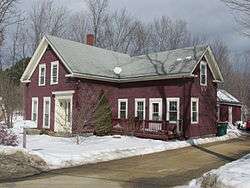 L'Ecole de Ballet on Willow Road | |
 Pingryville, Massachusetts | |
| Coordinates: 42°33′06″N 71°32′11″W / 42.55167°N 71.53639°WCoordinates: 42°33′06″N 71°32′11″W / 42.55167°N 71.53639°W | |
| Country | United States |
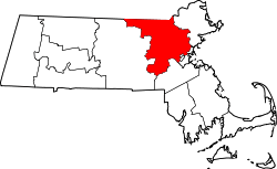
| State | Massachusetts |
| County | Middlesex |
| Towns | Ayer, Littleton |
| Elevation | 253 ft (77 m) |
| Time zone | UTC-5 (Eastern (EST)) |
| • Summer (DST) | UTC-4 (EDT) |
| ZIP code | 01460[1] |
| Area code(s) | 978 & 351 |
| GNIS feature ID | 611156[2] |
Pingryville is a village in the towns of Ayer and Littleton, Middlesex County, Massachusetts, United States. Massachusetts Route 2A and Massachusetts Route 110 pass through the community.[3] It is named after John Pingry VIII (1799-1860) who was a local farmer and deacon of the church.[4]
The community was mentioned in the song "Massachusetts" by Norwegian comedy duo Ylvis.[5]
References
- ↑ United States Postal Service (2012). "USPS - Look Up a ZIP Code". Retrieved 2012-02-15.
- ↑ "Pingryville". Geographic Names Information System. United States Geological Survey.
- ↑ Massachusetts Official Transportation Map (PDF) (Map). Massachusetts Department of Transportation. 2012.
- ↑ Pingry, William M (1881). A genealogical record of the descendants of Moses Pengry, of Ipswich, Mass., so far as ascertained. Ludlow VT: Warner & Hyde. pp. 35–36. Retrieved 16 August 2018.
- ↑ Reed, James (October 23, 2013). "'Massachusetts,' new song by Ylvis, takes off, falls flat". The Boston Globe. Retrieved January 16, 2014.
This article is issued from
Wikipedia.
The text is licensed under Creative Commons - Attribution - Sharealike.
Additional terms may apply for the media files.