Begampur, India
| Begampur | |
|---|---|
| Census town | |
 Begampur Location in West Bengal, India  Begampur Begampur (India) | |
| Coordinates: 22°44′12″N 88°15′06″E / 22.7368°N 88.2518°ECoordinates: 22°44′12″N 88°15′06″E / 22.7368°N 88.2518°E | |
| Country |
|
| State | West Bengal |
| District | Hooghly |
| Nearest City | Serampore |
| Government | |
| • Type | Gram Panchayat |
| • Body | Nagar Palika |
| Elevation | 15 m (49 ft) |
| Population (2011) | |
| • Total | 10,487 |
| Languages | |
| • Official | Bengali, English |
| Time zone | UTC+5:30 (IST) |
| ISO 3166 code | IN-WB |
| Vehicle registration | WB |
| Lok Sabha constituency | Hooghly |
| Vidhan Sabha constituency | Singur |
| Website |
wb |
Begampur is a census town and a gram panchayat in Chanditala II CD Block in Srirampore subdivision of Hooghly district in the state of West Bengal, India. It is under Chanditala police station.[1]
Geography
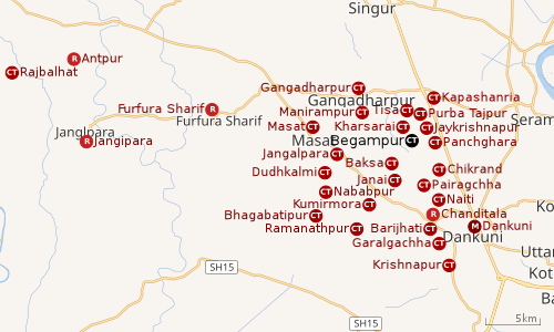 |
| Cities and towns in Chanditala I, Chanditala II and Jangipara CD Blocks in Srirampore subdivision in Hooghly district M: municipal city/ town, CT: census town, R: rural/ urban centre, Owing to space constraints in the small map, the actual locations in a larger map may vary slightly |
Location
Begampur is located at 22°44′12″N 88°15′06″E / 22.7368°N 88.2518°E
Kharsarai, Tisa, Kapashanria, Jaykrishnapur, Purba Tajpur, Begampur, Baksa, Panchghara, Chikrand, Janai, Pairagachha, Naiti, Barijhati, Garalgachha and Krishnapur, all the census towns form a series from the northern part of Chanditala II CD Block to its southern part. The only municipality in the area, Dankuni, located outside the CD Block, occupies the south-east corner of the entire cluster.[2]
Urbanisation
Srirampore subdivision is the most urbanized of the subdivisions in Hooghly district. 73.13% of the population in the subdivision is urban and 26.88% is rural. The subdivision has 6 municipalities and 34 census towns. The municipalities are: Uttarpara Kotrung Municipality, Konnagar Municipality, Serampore Municipality, Baidyabati Municipality, Rishra Municipality and Dankuni Municipality. Amongst the CD Blocks in the subdivision, Uttarapara Serampore (census towns shown in a separate map) had 76% urban population, Chanditala I 42%, Chanditala II 69% and Jangipara 7% (census towns shown in the map above).[3][4]All places marked in the map are linked in the larger full screen map.
Demographics
As per 2011 Census of India, Begampur had a total population of 10,487 of which 5,405 (52%) were males and 5,082 (48%) were females. Population below 6 years was 802. The total number of literates in Begampur was 8,504 (87.81% of the population over 6 years).[4]
As of 2001 India census,[5] Begampur had a population of 9545. Males constitute 51% of the population and females 49%. Begampur has an average literacy rate of 75%, higher than the national average of 59.5%; with 53% of the literates being male and 47% being female. 9% of the population is under 6 years of age.
Economy
Shantipur, Dhaniakhali, Begampur, and Farasdanga are the main cotton weaving centres in West Bengal which are involved in the weaving of fine-textured saris and dhotis. The saris of Begampur have deep and bright colours.[6] Begampur also produces the gorgeous jamdani saris.[7]
Around a total of 32 lakh people from all around the city commute to Kolkata daily for work. In the Howrah-Bardhaman (chord line) section there are 48 trains that carry commuters from 30 railway stations.[8]
Transport
Begampur is 23 kilometres (14 mi) from Howrah on the Howrah-Bardhaman chord line and is part of the Kolkata Suburban Railway system.[9]
Education
Begampur High School is a coeducational higher secondary school at Begampur. It has arrangements for teaching Bengali, English, history, philosophy, political science, education, physics, chemistry, mathematics and bio science.[10][11]
Healthcare
Begampur has a Primary Health Centre with 6 beds.[12][13]
References
- ↑ "District-wise list of stautory towns". Census Commission of India. Archived from the original on 2011-07-21. Retrieved 2009-01-28.
- ↑ "Census of India 2011, West Bengal: District Census Handbook, Hooghly" (PDF). Map of Chanditala II CD Block, page 663. Directorate of Census Operations, West Bengal. Retrieved 4 October 2018.
- ↑ "District Statistical Handbook 2014 Hooghly". Table 2.2, 2.4(a). Department of Statistics and Programme Implementation, Government of West Bengal. Retrieved 3 October 2018.
- 1 2 "C.D. Block Wise Primary Census Abstract Data(PCA)". 2011 census: West Bengal – District-wise CD Blocks. Registrar General and Census Commissioner, India. Retrieved 3 October 2018.
- ↑ "Census of India 2001: Data from the 2001 Census, including cities, villages and towns (Provisional)". Census Commission of India. Archived from the original on 2004-06-16. Retrieved 2008-11-01.
- ↑ "Crafts and Artisans of India". Textiles of West Bengal. craftandartisans.com. Archived from the original on 28 February 2009. Retrieved 2009-01-28.
- ↑ "World of the Indian Woman". Jamdani, the gorgeous saris of Bengal. Retrieved 2009-01-28.
- ↑ Dey, Teesta. "The Suburban Railway Network of Kolkata: A Geographical Apprisal" (PDF). eTraverse, the Indian journal of spatial science, 2012. Retrieved 8 October 2018.
- ↑ "36811 Howrah Bardhaman Local (via Chord)". indiarailinfo. Retrieved 6 October 2018.
- ↑ "Hooghly district exam venue". West Bengal Council of Higher Secondary Education. Retrieved 6 October 2018.
- ↑ "Begampur High School Hooghly". schoolspedia. Retrieved 6 October 2018.
- ↑ "Health & Family Welfare Department". Health Statistics. Government of West Bengal. Retrieved 4 October 2018.
- ↑ "Hooghly.gov.phc".