Rissa, Norway
| Rissa kommune | |||
|---|---|---|---|
| Former municipality | |||
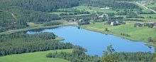
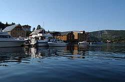 View of the harbour at Råkvåg | |||
| |||
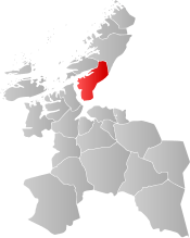 Rissa within Sør-Trøndelag | |||
| Coordinates: 63°39′20″N 10°02′23″E / 63.65556°N 10.03972°ECoordinates: 63°39′20″N 10°02′23″E / 63.65556°N 10.03972°E | |||
| Country | Norway | ||
| County | Sør-Trøndelag | ||
| District | Fosen | ||
| Established | 1860 | ||
| Disestablished | 1 Jan 2018 | ||
| Administrative centre | Årnset | ||
| Area | |||
| • Total | 621.37 km2 (239.91 sq mi) | ||
| • Land | 587.85 km2 (226.97 sq mi) | ||
| • Water | 33.52 km2 (12.94 sq mi) | ||
| Area rank | #179/426 in Norway | ||
| *Area at municipal dissolution. | |||
| Population (2017) | |||
| • Total | 6,628 | ||
| • Rank | #158/426 in Norway | ||
| • Density | 11.3/km2 (29/sq mi) | ||
| • Change (10 years) | 4.1% | ||
| Demonym(s) | Rissværing[1] | ||
| Time zone | UTC+01:00 (CET) | ||
| • Summer (DST) | UTC+02:00 (CEST) | ||
| ISO 3166 code | NO-1624 | ||
| Official language form | Neutral | ||
| Preceded by | Stadsbygd in 1860 | ||
| Succeeded by | Indre Fosen in 2018 | ||

Rissa is a former municipality in the old Sør-Trøndelag county in Norway in the Fosen region. The municipality existed from 1860 until its dissolution on 1 January 2018 when it became part of the municipality of Indre Fosen in Trøndelag county. The administrative centre of the municipality was the village of Årnset. Other villages in the municipality included Askjem, Hasselvika, Husbysjøen, Rørvika, Råkvåg, and Stadsbygd.
The 621-square-kilometre (240 sq mi) municipality was the 179th largest by area out of the then 426 municipalities in Norway. Rissa was the 158th most populous municipality in Norway with a population of 6,628. The municipality's population density was 11.3 inhabitants per square kilometre (29/sq mi) and its population had increased by 4.1% over the last decade.[2]
General information
The municipality of Rissen was established in 1860 when it was separated from the big municipality of Stadsbygd. Initially, Rissen had 3,733 residents. The spelling was later changed to Rissa. On 1 January 1905, the southwestern district of Lensvik (population: 1,019) on the west side of the Trondheimsfjord was separated from Rissa to form a municipality of its own. This left Rissa with 3,394 residents. During the 1960s, there were many municipal mergers across Norway due to the work of the Schei Committee. On 1 January 1964, most of Stadsbygd municipality (except for the Ingdalen area) and the southern part of the municipality of Stjørna were merged with Rissa to form a new, enlarged municipality of Rissa.[3]
On 1 January 2018, the neighboring municipalities of Rissa and Leksvik merged to form the new municipality of Indre Fosen which became part of the new Trøndelag county on the same date.[4]
Name
The Old Norse form of the name was Rissi. This was probably the old name of the brackish basin of Botn (literally "the bottom" of the fjord). Even though this is a heavily land-locked fjord with a river-like inlet from the Trondheimsfjord (it was probably a shallow bay in prehistoric times). The name is probably derived from the verb rísa which means "raise" or "rise". (The average water level of Botnen is today about 1.7 metres (5 ft 7 in) above mean sea level and the surface water is almost fresh from accumulated internal runoff.) The name of the municipality was historically spelled Rissen.[5]
Coat of arms
The coat of arms was from modern times; they were granted on 23 January 1987. The arms show a silver crown on a green background. The crown is that of Skule Bårdsson as it is depicted on an old tombstone at the Nidaros Cathedral. Bårdsson was the founder of Rein kloster and the accompanying farm and Rein estate, which lies in the municipality. The crown is a typical headdress used by the medieval Norwegian Dukes.[6]
Churches
The Church of Norway had four parishes (sokn) within the municipality of Rissa. It was part of the Fosen prosti (deanery) in the Diocese of Nidaros.
| Parish (Sokn) | Church Name | Location of the Church | Year Built |
|---|---|---|---|
| Hasselvika | Hasselvika Church | Hasselvika | 1951 |
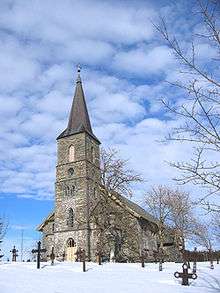
| Rissa | Rissa Church | Leira | 1888 |
| Rein Church | Reinsgrenda | 1932 | |
| Stadsbygd | Stadsbygd Church | Stadsbygd | 1842 |
| Sør-Stjørna | Ramsvik Church | Råkvåg | 1909 |
| Frengen Church | Frengen | 1972 |
History
In April 1978, Rissa was home to a quick-clay landslide which encompassed an area of 330,000 square metres (3,600,000 sq ft) and sent 6,000,000 cubic metres (7,800,000 cu yd) of clay from the Årnset area on the shore into Botn, causing a miniature tsunami on the north shore in Leira. This slide is particularly famous because a large portion of the slide happened to be recorded on film by two amateur photographers.
Government
The municipal government of Rissa was responsible for primary education (through 10th grade), outpatient health services, senior citizen services, unemployment and other social services, zoning, economic development, and municipal roads. The municipality is governed by a municipal council of elected representatives, which in turn elect a mayor.
Municipal council
The final municipal council (Kommunestyre) of Rissa that was elected to represent the municipality was made up of 23 representatives that were elected to four year terms. The last council party breakdown was as follows:[7]
| Party Name | Name in Norwegian | Number of representatives | |
|---|---|---|---|
| Labour Party | Arbeiderpartiet | 5 | |
| Progress Party | Fremskrittspartiet | 1 | |
| Conservative Party | Høyre | 7 | |
| Christian Democratic Party | Kristelig Folkeparti | 1 | |
| Green Party | Miljøpartiet De Grønne | 1 | |
| Pensioners' Party | Pensjonistpartiet | 2 | |
| Centre Party | Senterpartiet | 4 | |
| Socialist Left Party | Sosialistisk Venstreparti | 1 | |
| Liberal Party | Venstre | 1 | |
| Total number of members: | 23 | ||
Geography
The municipality is located on the southern end of the Fosen peninsula along the Trondheimsfjord and the Stjørnfjord. The large lake Storvatnet lies on the eastern border with Lensvik. To the north were the municipalities of Åfjord, Bjugn, and Ørland.
The Flakk–Rørvik Ferry crosses the Trondheimsfjord and connected the village of Rørvik with the city of Trondheim.
See also
References
- ↑ "Navn på steder og personer: Innbyggjarnamn" (in Norwegian). Språkrådet. Retrieved 2015-12-01.
- ↑ Statistisk sentralbyrå (2017). "Table: 06913: Population 1 January and population changes during the calendar year (M)" (in Norwegian). Retrieved 2017-10-07.
- ↑ Jukvam, Dag (1999). "Historisk oversikt over endringer i kommune- og fylkesinndelingen" (PDF) (in Norwegian). Statistisk sentralbyrå.
- ↑ "Om Indre Fosen" (in Norwegian). Retrieved 2017-10-07.
- ↑ Rygh, Oluf (1901). Norske gaardnavne: Søndre Trondhjems amt (in Norwegian) (14 ed.). Kristiania, Norge: W. C. Fabritius & sønners bogtrikkeri. p. 101.
- ↑ Norske Kommunevåpen (1990). "Nye kommunevåbener i Norden". Retrieved 27 October 2008.
- ↑ "Table: 04813: Members of the local councils, by party/electoral list at the Municipal Council election (M)" (in Norwegian). Statistics Norway. 2015.
External links
| Wikimedia Commons has media related to Rissa, Sør-Trøndelag. |

| |||||||
| |||||||
| |||||||

| Authority control |
|---|