Tydal
| Tydal kommune | |||
|---|---|---|---|
| Municipality | |||
 | |||
| |||
 Tydal within Trøndelag | |||
| Coordinates: 63°01′06″N 11°48′54″E / 63.01833°N 11.81500°ECoordinates: 63°01′06″N 11°48′54″E / 63.01833°N 11.81500°E | |||
| Country | Norway | ||
| County | Trøndelag | ||
| District | Neadalen | ||
| Established | 1 Jan 1901 | ||
| Administrative centre | Ås | ||
| Government | |||
| • Mayor (2015) | Ole Bjarne Østby (Sp) | ||
| Area | |||
| • Total | 1,329.21 km2 (513.21 sq mi) | ||
| • Land | 1,217.06 km2 (469.91 sq mi) | ||
| • Water | 112.15 km2 (43.30 sq mi) 8.4% | ||
| Area rank | #69 in Norway | ||
| Population (2017) | |||
| • Total | 861 | ||
| • Rank | #408 in Norway | ||
| • Density | 0.7/km2 (2/sq mi) | ||
| • Change (10 years) | 0.2% | ||
| Demonym(s) | Tydaling[1] | ||
| Time zone | UTC+01:00 (CET) | ||
| • Summer (DST) | UTC+02:00 (CEST) | ||
| ISO 3166 code | NO-5033 | ||
| Official language form | Bokmål | ||
| Website |
tydal | ||

Tydal is a municipality in Trøndelag county, Norway. The administrative centre of the municipality is the village of Ås. Other villages include Østby, Gressli, Aunet, and Stugudalen. There is a school and a kindergarten in Tydal.
The inhabitants of Tydal earn a living in farming, forestry, energy production, and tourism. During Easter, the number of people in Tydal increases by up to 5,000 people. Many people from Trondheim celebrate their holidays in the 1,400 cabins located throughout the municipality of Tydal.
The 1,329-square-kilometre (513 sq mi) municipality is the 69th largest by area out of the 422 municipalities in Norway. Tydal is the 408th most populous municipality in Norway with a population of 861. The municipality's population density is 0.7 inhabitants per square kilometre (1.8/sq mi) and its population has increased by 0.2% over the last decade.[2]
General information
The municipality of Tydal was established on 1 January 1901 when it was separated from the large municipality of Selbu. The initial population of Tydal was 881. The municipal borders have not changed since that time.[3] On 1 January 2018, the municipality switched from the old Sør-Trøndelag county to the newly created Trøndelag county.
Name
The municipality (originally the parish) is named after the Tya River. The first element of the name Tydal comes from the Old Norse: Þý, the old river name, which has no known meaning, and the last element (Old Norse: dalr) is means "valley" or "dale". The name was historically spelled Thidalen or Tydalen.[4]
Coat of arms
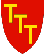
The coat of arms is from modern times; they were granted on 7 February 1997. It shows three gold Anthony's crosses on a red background. This was chosen to represent a power line and the letter T, representing the name of the municipality and the importance of hydroelectric power generation in Tydal.[5]
Churches
The Church of Norway has one parish (sokn) within the municipality of Tydal. It is part of the Stjørdal prosti (deanery) in the Diocese of Nidaros.
| Parish (Sokn) | Church Name | Location of the Church | Year Built |
|---|---|---|---|
| Tydal | Tydal Church | Aunet | 1696 |
| Stugudal Chapel | Stugudalen | 1957 |
Government
All municipalities in Norway, including Tydal, are responsible for primary education (through 10th grade), outpatient health services, senior citizen services, unemployment and other social services, zoning, economic development, and municipal roads. The municipality is governed by a municipal council of elected representatives, which in turn elect a mayor. The municipality falls under the Sør-Trøndelag District Court and the Frostating Court of Appeal.
Municipal council
The municipal council (Kommunestyre) of Tydal is made up of 17 representatives that are elected to four year terms. Currently, the party breakdown is as follows:[6]
| Party Name | Name in Norwegian | Number of representatives | |
|---|---|---|---|
| Centre Party | Senterpartiet | 12 | |
| Local Lists | Lokale lister | 5 | |
| Total number of members: | 17 | ||
Geography

Tydal covers an area of 1,330 square kilometres (510 sq mi). The rivers Tya River and Nea River (together forming the Nea-Nidelvvassdraget watershed) flow through Tydal on their way towards Trondheimsfjorden. Tydal is situated about 260 metres (850 ft) above sea level, and the highest mountain is 1,762 metres (5,781 ft) tall.
In the southwest, the lake Nesjøen lies just west of the Sylan mountain range with the mountain Storsylen. In the north, the Skarvan and Roltdalen National Park is home to the mountain Fongen.
Transportation
Tydal is halfway between Røros and Trondheim, with Norwegian national road 705 as the most important road through Tydal. Trondheim Airport, Værnes is one hour of driving away. There are daily bus connections to Trondheim, Værnes as well as to Røros.
References
- ↑ "Navn på steder og personer: Innbyggjarnamn" (in Norwegian). Språkrådet. Retrieved 2015-12-01.
- ↑ Statistisk sentralbyrå (2017). "Table: 06913: Population 1 January and population changes during the calendar year (M)" (in Norwegian). Retrieved 2017-10-08.
- ↑ Jukvam, Dag (1999). "Historisk oversikt over endringer i kommune- og fylkesinndelingen" (PDF) (in Norwegian). Statistisk sentralbyrå.
- ↑ Rygh, Oluf (1901). Norske gaardnavne: Søndre Trondhjems amt (in Norwegian) (14 ed.). Kristiania, Norge: W. C. Fabritius & sønners bogtrikkeri. p. 392.
- ↑ "Kommunevåpen" (in Norwegian). Tydal kommune. Retrieved 2008-10-28.
- ↑ "Table: 04813: Members of the local councils, by party/electoral list at the Municipal Council election (M)" (in Norwegian). Statistics Norway. 2015.
External links
| Wikimedia Commons has media related to Tydal. |

- Municipal fact sheet from Statistics Norway (in Norwegian)
| |||||||
| |||||||
| |||||||

| Authority control |
|---|