Nærøy
| Nærøy kommune | |||
|---|---|---|---|
| Municipality | |||
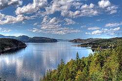 View of the Opløfjord in Nærøy | |||
| |||
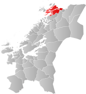 Nærøy within Trøndelag | |||
| Coordinates: 64°56′01″N 11°46′47″E / 64.93361°N 11.77972°ECoordinates: 64°56′01″N 11°46′47″E / 64.93361°N 11.77972°E | |||
| Country | Norway | ||
| County | Trøndelag | ||
| District | Namdalen | ||
| Established | 1 Jan 1838 | ||
| Administrative centre | Kolvereid | ||
| Government | |||
| • Mayor (1999) | Steinar Aspli (Sp) | ||
| Area | |||
| • Total | 1,067.54 km2 (412.18 sq mi) | ||
| • Land | 1,013.89 km2 (391.47 sq mi) | ||
| • Water | 53.65 km2 (20.71 sq mi) 5% | ||
| Area rank | #96 in Norway | ||
| Population (2017) | |||
| • Total | 5,138 | ||
| • Rank | #198 in Norway | ||
| • Density | 5.1/km2 (13/sq mi) | ||
| • Change (10 years) | 1.3% | ||
| Demonym(s) | Nærøyværing[1] | ||
| Time zone | UTC+01:00 (CET) | ||
| • Summer (DST) | UTC+02:00 (CEST) | ||
| ISO 3166 code | NO-5051 | ||
| Official language form | Bokmål | ||
| Website |
naroy | ||

Nærøy is a municipality in Trøndelag county, Norway. Nærøy is part of the Namdalen region. Norway's smallest town, Kolvereid, is the administrative centre of the municipality. Some villages in Nærøy include Abelvær, Foldereid, Gravvik, Lund, Ottersøy, Salsbruket, Steine, and Torstad.
The 1,068-square-kilometre (412 sq mi) municipality is the 96th largest by area out of the 422 municipalities in Norway. Nærøy is the 198th most populous municipality in Norway with a population of 5,138. The municipality's population density is 5.1 inhabitants per square kilometre (13/sq mi) and its population has increased by 1.3% over the last decade.[2]
General information
Nærøy was established as a municipality on 1 January 1838 (see formannskapsdistrikt). On 1 July 1869, the western island district was separated from Nærøy to become the new municipality of Vikten. This left Nærøy with 1,477 residents. On 1 January 1902, an unpopulated area of Kolvereid was transferred to Nærøy municipality.
During the 1960s, there were many municipal mergers across Norway due to the work of the Schei Committee. On 1 January 1964, the neighboring municipalities of Kolvereid (population: 2,426), Nærøy (population: 2,182), Gravvik (population: 816), and the western two-thirds of Foldereid were merged to form the new, larger municipality of Nærøy.[3]
On 8 June 2017, the Norwegian Parliament, the Storting, voted to merge the municipalities of Leka, Vikna, Nærøy, and Bindal to form one, large municipality effective 1 January 2020.[4] Leka and Bindal municipalities rejected the merger, but Vikna and Nærøy will merge on that date to form the new municipality of Nærøysund.[5]
On 1 January 2018, the municipality of Nærøy switched from the old Nord-Trøndelag county to the new Trøndelag county.
Name
The Old Norse form of the name was Njarðøy. The first element is maybe the stem form of the name of the Norse god Njord (but it is suspicious that it is not in the genitive case). The last element is øy which means "island". Historically, the name has had varying spellings such as Nærø or Nærøen.[6][7]
Coat of arms
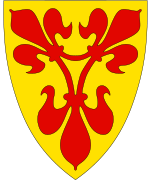
The coat of arms is from modern times; they were granted on 22 May 1987. The arms are based on the seal of King Håkon Magnusson from 1344, on a document in which the King granted several rights to the local farmers. The seal shows the St. Mary in a portal decorated with fleur-de-lis, the symbol of the St. Mary. The arms show a combination of three fleur-de-lis on a gold background. The fleur-de-lis design is red, since the local water lilies generally have a red color.[8]
Churches
The Church of Norway has four parishes (sokn) within the municipality of Nærøy. It is part of the Namdal prosti (deanery) in the Diocese of Nidaros.
| Parish (Sokn) | Church Name | Location of the Church | Year Built |
|---|---|---|---|
| Foldereid | Foldereid Church | Foldereid | 1863 |
| Gravvik | Gravvik Church | Gravvik | 1875 |
| Kolvereid | Kolvereid Church | Kolvereid | 1874 |
| Lund Chapel | Lund | 1965 | |
| Salsbruket Chapel | Salsbruket | 1950 | |
| Nærøy | Lundring Church | Lundring | 1885 |
| Steine Chapel | Steine | 1911 | |
| Torstad Chapel | Torstad | 1936 |
Geography
The municipality is located in the northwestern part of Trøndelag county, along the Foldafjord. It includes the islands of Austra and Gjerdinga and the Kvingra peninsula. Several large lakes are located in the municipality including Mjosundvatnet, Salsvatnet, and Storvatnet.
Government
All municipalities in Norway, including Nærøy, are responsible for primary education (through 10th grade), outpatient health services, senior citizen services, unemployment and other social services, zoning, economic development, and municipal roads. The municipality is governed by a municipal council of elected representatives, which in turn elect a mayor. The municipality falls under the Namdal District Court and the Frostating Court of Appeal.
Municipal council
The municipal council (Kommunestyre) of Nærøy is made up of 27 representatives that are elected to four year terms. Currently, the party breakdown is as follows:[9]
| Party Name | Name in Norwegian | Number of representatives | |
|---|---|---|---|
| Labour Party | Arbeiderpartiet | 9 | |
| Progress Party | Fremskrittspartiet | 2 | |
| Conservative Party | Høyre | 3 | |
| Christian Democratic Party | Kristelig Folkeparti | 1 | |
| Centre Party | Senterpartiet | 10 | |
| Socialist Left Party | Sosialistisk Venstreparti | 1 | |
| Liberal Party | Venstre | 1 | |
| Total number of members: | 27 | ||
Transportation
Norwegian County Road 17 crosses the northeastern part of the municipality. There is a large network of bridges in the municipality that connect islands and cross fjords. Most notably is the Marøysund Bridge and Nærøysund Bridge which connect Nærøy to Vikna to the west. Also Hestøy Bridge and Smines Bridge connect the village of Lund to Fosnes municipality to the south.
Media gallery
 Skrøyvstad waterfall in Nærøy
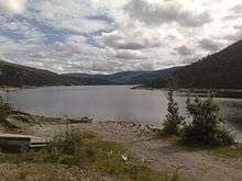 View of Mjøsund
 Torfjellet; pine clad hills and narrow bays and fjords are typical here
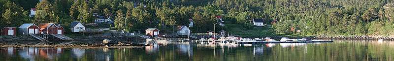 Panorama of the Langnes area in Salsbruket
 View of the Nærøysund Bridge
See also
References
- ↑ "Navn på steder og personer: Innbyggjarnamn" (in Norwegian). Språkrådet. Retrieved 2015-12-01.
- ↑ Statistisk sentralbyrå (2017). "Table: 06913: Population 1 January and population changes during the calendar year (M)" (in Norwegian). Retrieved 2017-09-26.
- ↑ Jukvam, Dag (1999). "Historisk oversikt over endringer i kommune- og fylkesinndelingen" (PDF) (in Norwegian). Statistisk sentralbyrå.
- ↑ "Kommunesammenslåing Nærøy, Vikna, Leka, og Bindal" (PDF) (in Norwegian). Leka kommune. 2017-08-21. Retrieved 2017-09-26.
- ↑ "Navn på ny kommune" (in Norwegian). Vikna kommune. 2018-02-05. Retrieved 2018-04-29.
- ↑ Store norske leksikon. "Nærøy – Nord-Trøndelag" (in Norwegian). Retrieved 2011-10-03.
- ↑ Rygh, Oluf (1903). Norske gaardnavne: Nordre Trondhjems amt (dokpro.uio.no) (in Norwegian) (15 ed.). Kristiania, Norge: W. C. Fabritius & sønners bogtrikkeri. p. 354.
- ↑ "Civic heraldry of Norway - Norske Kommunevåpen". Heraldry of the World. Retrieved 2018-04-29.
- ↑ "Table: 04813: Members of the local councils, by party/electoral list at the Municipal Council election (M)" (in Norwegian). Statistics Norway. 2015.
External links
| Wikimedia Commons has media related to Nærøy. |

- Municipal fact sheet from Statistics Norway (in Norwegian)
| |||||||
| |||||||
| |||||||
