Malvik
| Malvik kommune | |||
|---|---|---|---|
| Municipality | |||
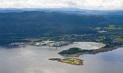 View of Muruvik in Malvik | |||
| |||
 Malvik within Trøndelag | |||
| Coordinates: 63°22′22″N 10°45′03″E / 63.37278°N 10.75083°ECoordinates: 63°22′22″N 10°45′03″E / 63.37278°N 10.75083°E | |||
| Country | Norway | ||
| County | Trøndelag | ||
| District | Trondheim Region | ||
| Established | 1891 | ||
| Administrative centre | Hommelvik | ||
| Government | |||
| • Mayor (2015) | Ingrid Aune (Ap) | ||
| Area | |||
| • Total | 168.44 km2 (65.04 sq mi) | ||
| • Land | 161.87 km2 (62.50 sq mi) | ||
| • Water | 6.57 km2 (2.54 sq mi) 3.9% | ||
| Area rank | #348 in Norway | ||
| Population (2017) | |||
| • Total | 13,820 | ||
| • Rank | #85 in Norway | ||
| • Density | 85.4/km2 (221/sq mi) | ||
| • Change (10 years) | 12.2% | ||
| Demonym(s) | Malvikbygg[1] | ||
| Time zone | UTC+01:00 (CET) | ||
| • Summer (DST) | UTC+02:00 (CEST) | ||
| ISO 3166 code | NO-5031 | ||
| Official language form | Bokmål | ||
| Website |
malvik | ||

Malvik is a municipality in Trøndelag county, Norway. It is part of the Trondheim Region. The administrative center of the municipality is the village of Hommelvik. Other villages in Malvik include Muruvika, Smiskaret, Sneisen, Vikhammer, and Hundhammeren.
While "Malvik" refers to the municipality as a whole, it also refers to the urban area of Malvik. The villages of Hundhammeren, Vikhammer, Saksvik (all in Malvik), and Væretrøa (in Trondheim) together form an urban area that is also called Malvik. The 2.63-square-kilometre (650-acre) urban area has a population (2017) of 6,949 which gives the area a population density of 2,642 inhabitants per square kilometre (6,840/sq mi).[2] This area is the most populous urban area in the municipality.[3]
The 168-square-kilometre (65 sq mi) municipality is the 348th largest by area out of the 422 municipalities in Norway. Malvik is the 85th most populous municipality in Norway with a population of 13,820. The municipality's population density is 85.4 inhabitants per square kilometre (221/sq mi) and its population has increased by 12.2% over the last decade.[4]
General information
The municipality of Malvik was established in 1891 when it was separated from the large municipality of Strinda. On 1 January 1914, a small area of Lånke (population: 38) was transferred to Malvik. On 1 July 1953, a small area of Malvik (population: 37) was transferred to the neighboring municipality of Strinda.[5] On 1 January 2018, the municipality switched from the old Sør-Trøndelag county to the new Trøndelag county.
Name
The municipality (originally the parish) is named after the old Malvik farm (Old Norse: Manvík), since the first Malvik Church was built there. The first element is probably the word mǫn (stem form man-) which means "mane", referring to a mountain ridge behind the farm. (Mana which means "the mane" is a common name for many mountains in Norway, where the form of the mountain is compared with the mane of a horse.) The last element (Old Norse: Vík) is identical with the word vik which means "inlet".[6]
Coat of arms
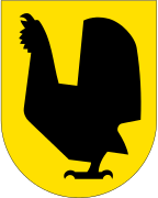
The coat of arms is from modern times; they were granted on 23 July 1982. The yellow arms show a black capercaillie, chosen as a symbol for the rich nature in the area.[7]
Churches
The Church of Norway has two parishes (sokn) within the municipality of Malvik. It is part of the Stjørdal prosti (deanery) in the Diocese of Nidaros.
| Parish (Sokn) | Church Name | Location of the Church | Year Built |
|---|---|---|---|
| Hommelvik | Hommelvik Church | Hommelvik | 1886 |
| Mostadmark Chapel | Sneisen | 1986 | |
| Malvik | Malvik Church | Malvik | 1846 |
Geography
Malvik is just to the east of the city of Trondheim, one of Norway's largest cities. Many people in Malvik have their place of employment in Trondheim, though there is some local industry in Malvik itself.
The northern part of Malvik lies along the Trondheimsfjord, and it is along this coastal section that the vast majority of the population lives, and where schools, and places of employment are located. The municipal center is Hommelvik, situated about 25 kilometres (16 mi) east of Trondheim, and it has long been the main population area in Malvik. In the last few decades the area around Vikhammer and Hundhammeren (about 10 kilometres or 6.2 miles to the west) has grown larger than Hommelvik. The area has many new housing areas, businesses, and shopping. Collectively, the new area is referred to as the Malvik urban area.[2]
The southern part of the municipality consists mostly of farming and forest areas, with many attractive areas for hiking and cross-country skiing. The Homla river runs north to the Trondheimsfjord. The lake Jonsvatnet lies on the western border of the municipality.
In the southeastern part of Malvik there is the Jøsås exclaves. Three farmsteads, Øvre Jøsås, Store Jøsås, and Lille Jøsås belonging to Malvik municipality are exclaved inside Stjørdal municipality in two different exclaves. Øvre Jøsås and Store Jøsås are located in one exclave (the western one) while Lille Jøsås is making another exclave (the eastern one). The exclaves only have road access to Malvik municipality even though they are inside Stjørdal's borders. The distance between the two exclaves is very small, only about 8 metres (26 ft) at the nearest.[8]
Government
All municipalities in Norway, including Malvik, are responsible for primary education (through 10th grade), outpatient health services, senior citizen services, unemployment and other social services, zoning, economic development, and municipal roads. The municipality is governed by a municipal council of elected representatives, which in turn elect a mayor. The municipality falls under the Sør-Trøndelag District Court and the Frostating Court of Appeal.
Municipal council
The municipal council (Kommunestyre) of Malvik is made up of 31 representatives that are elected to four year terms. Currently, the party breakdown is as follows:[9]
| Party Name | Name in Norwegian | Number of representatives | |
|---|---|---|---|
| Labour Party | Arbeiderpartiet | 12 | |
| Progress Party | Fremskrittspartiet | 3 | |
| Conservative Party | Høyre | 5 | |
| Christian Democratic Party | Kristelig Folkeparti | 1 | |
| Green Party | Miljøpartiet De Grønne | 2 | |
| Pensioners' Party | Pensjonistpartiet | 1 | |
| Centre Party | Senterpartiet | 3 | |
| Socialist Left Party | Sosialistisk Venstreparti | 1 | |
| Liberal Party | Venstre | 2 | |
| Local Lists | Lokale lister | 1 | |
| Total number of members: | 31 | ||
Transportation
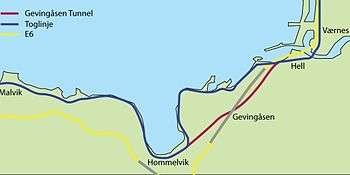
To the east of Malvik is the municipality of Stjørdal, which includes Trondheim Airport, Værnes. The airport has frequent connections to many locations in Norway, and a growing range of direct air links abroad (currently including London, Amsterdam, Copenhagen, Stockholm, and Prague). The proximity of this airport means that Malvik, though a small community in a relatively isolated location, has rather good transport connections very close at hand. The European route E6 highway runs through Malvik and it has several tunnels, the longest of which is the Hell Tunnel.
The Nordland Line runs from Trondheim to Bodø (further north in Norway) and the Meråker Line runs east to Sweden. The railroad winds its way along the coast of the Trondheimsfjord in Malvik, and is a very scenic and pleasant journey. Malvik has two railway stations: Vikhammer Station and Hommelvik Station. The Gevingåsen Tunnel is being built to shorten the rail trip from Trondheim to Stjørdal. A side effect of this is that the scenic attractiveness of the trip will be somewhat reduced, as part of the section along the fjord will no longer form part of the trip. The railway junction where the line splits for Bodø or Sweden is just to the east of Malvik, at a small settlement called Hell. The station is well known to railway enthusiasts from its odd name (for English language speakers). It is indeed possible, in Malvik, to purchase "a single ticket to Hell" or a return "to Hell and back".
Notable residents
- Johan Nygaardsvold (1879–1952), Norway's prime minister from 1935 to 1945,
- Kåre Ingebrigtsen (1965–), football player (Rosenborg BK)
- Ingvild Vaggen Malvik (1971–), Politician (SV)
References
- ↑ "Navn på steder og personer: Innbyggjarnamn" (in Norwegian). Språkrådet. Retrieved 2015-12-01.
- 1 2 Statistisk sentralbyrå (1 January 2017). "Urban settlements. Population and area, by municipality".
- ↑ Olsen Haugen, Morten, ed. (2017-09-12). "Vikhammer". Store norske leksikon (in Norwegian). Kunnskapsforlaget. Retrieved 2018-03-22.
- ↑ Statistisk sentralbyrå (2017). "Table: 06913: Population 1 January and population changes during the calendar year (M)" (in Norwegian). Retrieved 2017-10-08.
- ↑ Jukvam, Dag (1999). "Historisk oversikt over endringer i kommune- og fylkesinndelingen" (PDF) (in Norwegian). Statistisk sentralbyrå.
- ↑ Rygh, Oluf (1901). Norske gaardnavne: Søndre Trondhjems amt (in Norwegian) (14 ed.). Kristiania, Norge: W. C. Fabritius & sønners bogtrikkeri. p. 356.
- ↑ "Civic heraldry of Norway - Norske Kommunevåpen". Heraldry of the World. Retrieved 2018-03-22.
- ↑ Jan S. Krogh. "Domestic enclaves/exclaves of Norway". Retrieved 2011-03-11.
- ↑ "Table: 04813: Members of the local councils, by party/electoral list at the Municipal Council election (M)" (in Norwegian). Statistics Norway. 2015.
External links


- Municipal Homepage (in Norwegian)
- Municipal fact sheet from Statistics Norway (in Norwegian)
| |||||||
| |||||||
| |||||||

| Authority control |
|---|