Osen
| Osen kommune | |||
|---|---|---|---|
| Municipality | |||
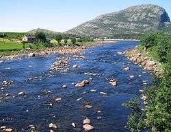 View of the Osen river | |||
| |||
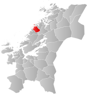 Osen within Trøndelag | |||
| Coordinates: 64°17′52″N 10°30′48″E / 64.29778°N 10.51333°ECoordinates: 64°17′52″N 10°30′48″E / 64.29778°N 10.51333°E | |||
| Country | Norway | ||
| County | Trøndelag | ||
| District | Fosen | ||
| Established | 1 June 1892 | ||
| Administrative centre | Steinsdalen | ||
| Government | |||
| • Mayor (2015) | John Einar Høvik (Ap) | ||
| Area | |||
| • Total | 387.18 km2 (149.49 sq mi) | ||
| • Land | 369.69 km2 (142.74 sq mi) | ||
| • Water | 17.49 km2 (6.75 sq mi) 4.5% | ||
| Area rank | #242 in Norway | ||
| Population (2017) | |||
| • Total | 978 | ||
| • Rank | #397 in Norway | ||
| • Density | 2.6/km2 (7/sq mi) | ||
| • Change (10 years) | -6.9% | ||
| Demonym(s) | Osing[1] | ||
| Time zone | UTC+01:00 (CET) | ||
| • Summer (DST) | UTC+02:00 (CEST) | ||
| ISO 3166 code | NO-5020 | ||
| Official language form | Bokmål | ||
| Website |
osen | ||


Osen is a municipality in Trøndelag county, Norway. It is part of the Fosen region. The administrative centre of the municipality is the village of Steinsdalen. Osen is one of two Norwegian municipalities that do not have any non-western immigrants as of 1 January 2008.[2]
The 387-square-kilometre (149 sq mi) municipality is the 242nd largest by area out of the 422 municipalities in Norway. Osen is the 397th most populous municipality in Norway with a population of 978. The municipality's population density is 2.6 inhabitants per square kilometre (6.7/sq mi) and its population has decreased by 6.9% over the last decade.[3]
General information

The municipality of Osen was established on 1 June 1892 when the old municipality of Bjørnør was split into three new municipalities: Osen (population: 1,575), Roan (population: 2,069), and Stoksund (population: 1,122). The municipal boundaries have not changed since.[4] On 1 January 2018, the municipality switched from the old Sør-Trøndelag county to the new Trøndelag county.
Name
The municipality (originally the parish) is named after the old Osen farm (Old Norse: Óss), since the first church was built there. The name is identical with the word óss which means "mouth of a river" (here Steinselva). Osen ("the Os") is a later finite form of óss.[5]
Coat of arms
The coat of arms is from modern times; they were granted on 27 March 1987, and is a copy of an old petroglyph. The arms show a part of a fishing net placed over the blue shield. The arms simply indicate the importance of fishing for the community. Several different arms were designed, all with fisheries as the main theme, but the council finally chose this one, which is unique among civic heraldry.[6]
Churches
The Church of Norway has one parish (sokn) within the municipality of Osen. It is part of the Fosen prosti (deanery) in the Diocese of Nidaros.
| Parish (Sokn) | Church Name | Location of the Church | Year Built |
|---|---|---|---|
| Osen | Osen Church | Steinsdalen | 1877 |
| Seter Chapel (Osen) | Seter | 1969 |
History
Osen was used as a satellite prison camp during the World War Two, mainly for Yugoslavian population.
Government
All municipalities in Norway, including Osen, are responsible for primary education (through 10th grade), outpatient health services, senior citizen services, unemployment and other social services, zoning, economic development, and municipal roads. The municipality is governed by a municipal council of elected representatives, which in turn elect a mayor. The municipality falls under the Fosen District Court and the Frostating Court of Appeal.
Municipal council
The municipal council (Kommunestyre) of Osen is made up of 15 representatives that are elected to four year terms. Currently, the party breakdown is as follows:[7]
| Party Name | Name in Norwegian | Number of representatives | |
|---|---|---|---|
| Labour Party | Arbeiderpartiet | 5 | |
| Progress Party | Fremskrittspartiet | 1 | |
| Conservative Party | Høyre | 1 | |
| Centre Party | Senterpartiet | 3 | |
| Local Lists | Lokale lister | 5 | |
| Total number of members: | 15 | ||
Geography
The municipality of Osen is located to the north of Roan and the ocean lies to the west.
Most of the residents live in the Steinsdalen valley or along the coast. The northern part of the municipality has no direct road connection to the rest of the municipality, but is connected to the municipality of Flatanger to the north.
The Kya lighthouse and Buholmråsa lighthouse lie in the ocean in the western part of the municipality.
See also
References
- ↑ "Navn på steder og personer: Innbyggjarnamn" (in Norwegian). Språkrådet. Retrieved 2015-12-01.
- ↑ "Tabell 10 Innvandrerbefolkningen, etter vestlig og ikke-vestlig landbakgrunn og kommune" (in Norwegian). Statistics Norway. 1 January 2008. Archived from the original on 13 September 2008.
- ↑ Statistisk sentralbyrå (2017). "Table: 06913: Population 1 January and population changes during the calendar year (M)" (in Norwegian). Retrieved 2017-10-07.
- ↑ Jukvam, Dag (1999). "Historisk oversikt over endringer i kommune- og fylkesinndelingen" (PDF) (in Norwegian). Statistisk sentralbyrå.
- ↑ Rygh, Oluf (1901). Norske gaardnavne: Søndre Trondhjems amt (in Norwegian) (14 ed.). Kristiania, Norge: W. C. Fabritius & sønners bogtrikkeri. p. 3.
- ↑ "Civic heraldry of Norway - Norske Kommunevåpen". Heraldry of the World. Retrieved 2018-05-05.
- ↑ "Table: 04813: Members of the local councils, by party/electoral list at the Municipal Council election (M)" (in Norwegian). Statistics Norway. 2015.
External links


- Municipal fact sheet from Statistics Norway (in Norwegian)
| |||||||
| |||||||
| |||||||
