Flatanger
| Flatanger kommune | |||
|---|---|---|---|
| Municipality | |||
 | |||
| |||
 Flatanger within Trøndelag | |||
| Coordinates: 64°25′11″N 10°54′28″E / 64.41972°N 10.90778°ECoordinates: 64°25′11″N 10°54′28″E / 64.41972°N 10.90778°E | |||
| Country | Norway | ||
| County | Trøndelag | ||
| District | Namdalen | ||
| Established | 1871 | ||
| Administrative centre | Lauvsnes | ||
| Government | |||
| • Mayor (2011) | Olav Jørgen Bjørkås (Sp) | ||
| Area | |||
| • Total | 458.71 km2 (177.11 sq mi) | ||
| • Land | 433.52 km2 (167.38 sq mi) | ||
| • Water | 25.19 km2 (9.73 sq mi) 7.3% | ||
| Area rank | #221 in Norway | ||
| Population (2017) | |||
| • Total | 1,090 | ||
| • Rank | #387 in Norway | ||
| • Density | 2.5/km2 (6/sq mi) | ||
| • Change (10 years) | -6.7% | ||
| Demonym(s) | Flatangring[1] | ||
| Time zone | UTC+01:00 (CET) | ||
| • Summer (DST) | UTC+02:00 (CEST) | ||
| ISO 3166 code | NO-5049 | ||
| Official language form | Neutral | ||
| Website |
flatanger | ||


Flatanger is a municipality in Trøndelag county, Norway. It is part of the Namdalen region. The administrative centre of the municipality is the village of Lauvsnes. Other villages include Jøssund, Hasvåg, and Vik.
The 459-square-kilometre (177 sq mi) municipality is the 221st largest by area out of the 422 municipalities in Norway. Flatanger is the 387th most populous municipality in Norway with a population of 1,090. The municipality's population density is 2.5 inhabitants per square kilometre (6.5/sq mi) and its population has decreased by 6.7% over the last decade.[2]
Flatanger is also known for having some of the most difficult sport climbing routes in the world.
General information
Flatanger was established as a municipality in the old Nord-Trøndelag county on 1 January 1871 when it was separated from the large municipality of Fosnes. Initially, Flatanger had 1,472 residents. It is one of the few municipalities in Norway whose boundaries have not changed since it was established.[3] In 2018, it became part of the new Trøndelag county.
Name
The municipality is named after the old name for one of the fjords in the area, but it is not known which one. The name is composed of two parts: flat, which probably means "shallow water", and angr, which means "fjord or inlet".[4][5]
Coat of arms
The coat of arms is from modern times; they were granted on 12 October 1990. The arms show three silver or white chevrons on a green background. The design was chosen to represent the bow of a boat, seen from the front, since boats have a great historical significance in this coastal fishing community.[6]
Churches
The Church of Norway has one parish (sokn) within the municipality of Flatanger. It is part of the Namdal prosti (deanery) in the Diocese of Nidaros.
| Parish (Sokn) | Church Name | Location of the Church | Year Built |
|---|---|---|---|
| Flatanger | Vik Church | Vik | 1873 |
| Løvøy Church | Lauvøya | 1871 |
Geography
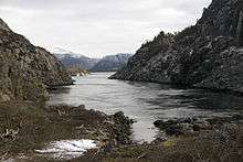
The municipality consists mostly of mainland, but also includes almost 1,400 islands of various sizes. Some of the major islands include Bjørøya, Lauvøya, Villa, Halmøya, and Kvernøya. Ellingråsa Lighthouse is located on the island of Bjørøya and Villa Lighthouse is on Villa. These islands all lie on the south side of the Folda firth. The Namsenfjorden forms part of the northern boundary of the municipality. The municipality falls under the Namdal District Court and the Frostating Court of Appeal.
Government
All municipalities in Norway, including Flatanger, are responsible for primary education (through 10th grade), outpatient health services, senior citizen services, unemployment and other social services, zoning, economic development, and municipal roads. The municipality is governed by a municipal council of elected representatives, which in turn elect a mayor.
Municipal council
The municipal council (Kommunestyre) of Flatanger is made up of 15 representatives that are elected to four year terms. Currently, the party breakdown is as follows:[7]
| Party Name | Name in Norwegian | Number of representatives | |
|---|---|---|---|
| Labour Party | Arbeiderpartiet | 3 | |
| Progress Party | Fremskrittspartiet | 2 | |
| Conservative Party | Høyre | 2 | |
| Centre Party | Senterpartiet | 4 | |
| Socialist Left Party | Sosialistisk Venstreparti | 2 | |
| Liberal Party | Venstre | 2 | |
| Total number of members: | 15 | ||
Politics
In the 2007 municipal elections, Flatanger had the highest vote for the Venstre party in all of Norway, at 42.9 per cent.
Rock Climbing
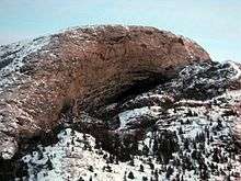
Flatanger is home to some of the world's hardest sport climbs, particularly in Hanshelleren Cave near town. Change, given the grade 9b+/5.15c+, was first redpointed by Adam Ondra on 4 October 2012. Ondra also redpointed the first, and to date only, 9c climbing route in the world in Flatanger on 3 September 2017. The route was originally named Project Hard by Ondra because of its many difficulties, but after completion - when it was no longer a project - he renamed it Silence.[8][9]

Famous people from Flatanger
- Brede Moe, a footballer
- Adolf Ribsskog, a school man and mayor
- Ole Konrad Ribsskog, a school man and mayor
- Toralf Sandø, a theater director and actor
- Julie Dahle Aagård, a singer
References
- ↑ "Navn på steder og personer: Innbyggjarnamn" (in Norwegian). Språkrådet. Retrieved 2015-12-01.
- ↑ Statistisk sentralbyrå (2017). "Table: 06913: Population 1 January and population changes during the calendar year (M)" (in Norwegian). Retrieved 2017-09-25.
- ↑ Jukvam, Dag (1999). "Historisk oversikt over endringer i kommune- og fylkesinndelingen" (PDF) (in Norwegian). Statistisk sentralbyrå.
- ↑ Store norske leksikon. "Flatanger" (in Norwegian). Retrieved 2011-08-18.
- ↑ Rygh, Oluf (1903). Norske gaardnavne: Nordre Trondhjems amt (dokpro.uio.no) (in Norwegian) (15 ed.). Kristiania, Norge: W. C. Fabritius & sønners bogtrikkeri. p. 344.
- ↑ "Civic heraldry of Norway - Norske Kommunevåpen". Heraldry of the World. Retrieved 2018-04-18.
- ↑ "Table: 04813: Members of the local councils, by party/electoral list at the Municipal Council election (M)" (in Norwegian). Statistics Norway. 2015.
- ↑ "Adam Ondra climbs world's first 9c at Flatanger in Norway". 2017-09-04.
- ↑ "Facebook photo". 2017-09-08.
External links


- Municipal fact sheet from Statistics Norway (in Norwegian)
| |||||||
| |||||||
| |||||||

| Authority control |
|---|