Sør-Trøndelag
| Sør-Trøndelag fylke | ||
|---|---|---|
| County | ||
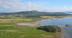 Isle Bruholmen with parts of Austrått and Rusaset by the mid-2000's | ||
| ||
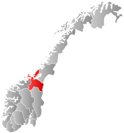 Sør-Trøndelag within Norway | ||
| Country | Norway | |
| County | Sør-Trøndelag | |
| Region | Trøndelag | |
| County ID | NO-16 | |
| Administrative centre | Trondheim | |
| Government | ||
| • Governor | Brit Skjelbred | |
| • County mayor |
Tore O. Sandvik Arbeiderpartiet | |
| Area | ||
| • Total | 18,848 km2 (7,277 sq mi) | |
| • Land | 17,830 km2 (6,880 sq mi) | |
| Area rank | # in Norway, 5.86% of Norway's land area | |
| Population (2017) | ||
| • Total | 317,363[1] | |
| • Rank | 5 (5.90% of country) | |
| • Density | 15/km2 (40/sq mi) | |
| • Change (10 years) | 5.8 % | |
| Demonym(s) | Sørtrønder | |
| Time zone | UTC+01 (CET) | |
| • Summer (DST) | UTC+02 (CEST) | |
| Official language form | Neutral | |
| Income (per capita) | 139,200 NOK | |
| GDP (per capita) | 243,281 NOK (2001) | |
| GDP national rank | 5 (4.23% of country) | |
| Website |
www | |
|
| ||

Sør-Trøndelag [ˈsøːr ²trøndəlɑːɡ] (![]()
The regions was divided into two administrative counties in 1804. In 2016, the two county councils voted to merge into a single county on 1 January 2018.[3]
Name
| Historical population | ||
|---|---|---|
| Year | Pop. | ±% |
| 1951 | 197,687 | — |
| 1961 | 211,819 | +7.1% |
| 1971 | 234,022 | +10.5% |
| 1981 | 244,760 | +4.6% |
| 1991 | 251,076 | +2.6% |
| 2001 | 264,865 | +5.5% |
| 2011 | 294,066 | +11.0% |
| Source: SSB.no, Statistics Norway.[4] | ||
The name Sør-Trøndelag was created in 1919. It means '(the) southern (part of) Trøndelag'.
Until 1919 the name of the county was Søndre Trondhjems amt. The meaning of this name was '(the) southern (part of) Trondhjems amt'. (The old Trondhjems amt, created in 1662, was divided in 1804. Trondhjem is the old form of Trondheim.)
See also Nord-Trøndelag
Coat-of-arms
The coat-of-arms was from modern times (1983) - but it had old roots: it was the seal of Gaute Ivarsson, archbishop of Trondheim 1475-1510.
Geography
Sør-Trøndelag consisted of 25 municipalities and had a total area of 18,848 square kilometres (7,277 sq mi). Trondheim is the largest city and the county’s administrative center.
The broad and long Trondheimsfjord is at the center of this county, although the coastal areas stretch somewhat further north. The mountain ranges Dovrefjell and Trollheimen are located in the south, while the Fosen peninsula is located north of the fjord. The highest mountain is the 1,985-metre (6,512 ft) tall Storskrymten, which is located in the county border between Møre og Romsdal, Oppland, and Trondelag. Its longest river is Orkla which runs through Trøndelag and Hedmark.
Several of the best salmon rivers in Europe are located in the county, the largest and most famous being Gaula and Orklaelva. Dovrefjell–Sunndalsfjella National Park, Forollhogna National Park, Skarvan and Roltdalen National Park and Femundsmarka National Park are located, or partly located, in the county.[5]
History
People have lived in this region for thousands of years (see Rock carvings in Central Norway, Nøstvet and Lihult cultures and Corded Ware culture). The fertile lowland bordering the Trondheimsfjord was probably the most important power centre in the Viking Age. Oretinget was an assembly hall located alongside the Nid River in Trondheim that served as the coronation place for Viking kings such as Harald Fairhair (865 to 933 AD) and his son Haakon I the Good. Nidaros (the former name of Trondheim) served as Norway's capital during the Viking era up until the early part of the 13th century.
Trondheim was the seat of the archbishop for several centuries, and an important pilgrimage destination following the death of St Olav in 1030.
Røros, in the southeastern part of the county, is a well-preserved mining town on a mountain plateau, and is a Unesco World Heritage Site.
Economy
Mining in Røros and Løkken in Meldal lasted for about 300 years, and Thamshavnbanen, the old electric railway from Orkdal to Løkken, is still usable. The constant fires used to crack the rock in the mines demanded vast amounts of firewood; the montane forests on the mountain plateau near Røros still have not fully recovered. Along the coast, fishing has always been important. Farming was and still is important in the whole county, with the most economical important agriculture taking place in the fertile lowland valleys, such as in Melhus, Orkdal, Skaun, Midtre Gauldal, Malvik and Trondheim, but also near the outer seaboard, such as in Ørland and Rissa. The city of Trondheim has always been at the centre of this area, with administrative functions, as well as industry based on agricultural produce, and more recently education, high-tech business and healthcare.
Transportation
Sør-Trøndelag is connected to the other counties by the European Route 6 (E6) which passes by Trondheim and connects Oslo in the south and runs north along the coast and terminates just east of Kirkenes in Finnmark. European route E39 connects Sør-Trøndelag to Møre og Romsdal.
There are two airports in Sør-Trøndelag: Røros airport and Ørland airport. Trondheim’s airport, Værnes, is actually located in Stjørdal in Nord-Trøndelag.
There are local trains that connect several municipalities; there are also trains that connect Trondheim to Oslo, Bodø, Røros, and Steinskjer in Norway, as well as Storlien in Sweden.[6][7]
Hurtigruten's coastal liner has daily, early- to mid-morning stops in Trondheim on both north- and south-bound trips.[8] There are also frequent commuter boats that connect smaller communities including some that connect Trondheim to Vanviken as well as other ports of call including: Brekstad; Kjørsvikbugen; Volden, Hitra; and Kristiansund.[9][10]
Additionally, during the summer months larger cruise ships stop in Trondheim.
Climate
The weather is very much decided by the direction of the wind; southerlies and easterlies bring sunny weather, while westerlies bring precipitation with mild weather in winter and cool rainy weather in summer. Northwesterlies bring the worst weather with snow in winter (often sleet or rain on the coast). Average yearly precipitation varies from 2,000 mm in some areas of Fosen, to 850 mm in Trondheim and only 500 mm in Oppdal. The interior areas at somewhat higher elevations have cold winters with reliable snow cover, while the coastal areas have a maritime climate with mild and more windy winters. Sula in Frøya municipality has an average of 1.5 °C (34 °F) in the coldest month.[11] Røros, at an altitude of 628 m (2,000 ft), has a January average of -11.2 °C (12 °F;[11] Summer temperatures do not differ that much; sheltered lowlands a bit inland will have the warmest summers. Base period 1961-1990.
Gallery
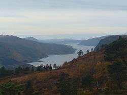 Vinjefjorden in Hemne.
 Nidaros Cathedral, Trondheim
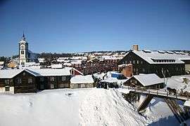 Rørosmartna - Røros winter market; February 2007
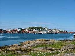 Sula island in Frøya municipality
Municipalities
| Rank | Name | Inhabitants[14] | Area km2 |
|---|---|---|---|
| 1 | 176,008 | 324 | |
| 2 | 14,841 | 660 | |
| 3 | 12,550 | 162 | |
| 4 | 11,276 | 567 | |
| 5 | 6,626 | 213 | |
| 6 | 6,603 | 2,207 | |
| 7 | 6,442 | 590 | |
| 8 | 6,012 | 1,817 | |
| 9 | 5,801 | 177 | |
| 10 | 5,576 | 1,764 | |
| 11 | 5,121 | 73 | |
| 12 | 4,548 | 356 | |
| 13 | 4,314 | 230 | |
| 14 | 4,256 | 646 | |
| 15 | 4,207 | 638 | |
| 16 | 4,004 | 1,147 | |
| 17 | 3,929 | 597 | |
| 18 | 3,220 | 900 | |
| 19 | 2,622 | 929 | |
| 20 | 2,064 | 1,177 | |
| 21 | 1,719 | 297 | |
| 22 | 1,033 | 371 | |
| 23 | 999 | 357 | |
| 24 | 998 | 490 | |
| 25 | 859 | 1,221 | |
| Total | 290,547 | 18,848 |
| Wikimedia Commons has media related to Sør-Trøndelag. |
| Wikivoyage has a travel guide for Sør-Trøndelag. |
References
- ↑ https://www.citypopulation.de/php/norway-admin.php?adm1id=16
- ↑ "History Trøndelag". Retrieved 21 May 2015.
- ↑ Hofstad, Sigrun. 2016. Her bankes det for et samlet Trøndelag. NRK (April 27).
- ↑ "Projected population - Statistics Norway". Statbank.ssb.no. Archived from the original on 2012-05-26. Retrieved 2013-07-01.
- ↑ Haugan, Trygve B., ed. (1940). Det Nordlige Norge Fra Trondheim Til Midnattssolens Land (in Norwegian). Trondheim: Reisetrafikkforeningen for Trondheim og Trøndelag.
- ↑ "Trønderbanen – Lokaltog i Trondheim og Trøndelag". NSB. Retrieved 20 May 2015.
- ↑ "Transport". City of Trondheim. Retrieved 20 May 2015.
- ↑ "Hurtigruten Havner". Hurtigruten. Retrieved 20 May 2015.
- ↑ "Trondheim - Brekstad - Kristiansund". Fosen Namsos Sjø. Retrieved 20 May 2015.
- ↑ Ham, Anthony; Roddis, Miles; Lundgren, Kari (2008). Norway. Lonely Planet. p. 285. ISBN 1741045797.
- 1 2 MET.no, kommuner Temperaturnormaler/Nedbørnormaler for Frøya i perioden 1961 - 1990 (in Norwegian)
- ↑ "Statistics Norway - Church of Norway". Statbank.ssb.no. Archived from the original on 2012-07-16. Retrieved 2013-07-01.
- ↑ Statistics Norway - Members of religious and life stance communities outside the Church of Norway, by religion/life stance. County. 2006-2010 Archived June 29, 2011, at the Wayback Machine.
- ↑ Statistics Norway (1 January 2010). "www.ssb.no".