Hitra
| Hitra kommune | |||||
|---|---|---|---|---|---|
| Municipality | |||||
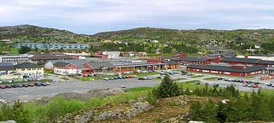 View of Fillan in Hitra | |||||
| |||||
 Hitra within Trøndelag | |||||
| Coordinates: 63°32′50″N 08°51′17″E / 63.54722°N 8.85472°ECoordinates: 63°32′50″N 08°51′17″E / 63.54722°N 8.85472°E | |||||
| Country | Norway | ||||
| County | Trøndelag | ||||
| District | Fosen | ||||
| Established | 1 Jan 1838 | ||||
| Administrative centre | Fillan | ||||
| Government | |||||
| • Mayor (2007) | Ole L. Haugen (Ap) | ||||
| Area | |||||
| • Total | 680.39 km2 (262.70 sq mi) | ||||
| • Land | 643.88 km2 (248.60 sq mi) | ||||
| • Water | 36.51 km2 (14.10 sq mi) 5.4% | ||||
| Area rank | #165 in Norway | ||||
| Population (2017) | |||||
| • Total | 4,659 | ||||
| • Rank | #214 in Norway | ||||
| • Density | 7.2/km2 (19/sq mi) | ||||
| • Change (10 years) | 15.7% | ||||
| Demonym(s) |
Hitraværing Hitterværing[1] | ||||
| Time zone | UTC+01:00 (CET) | ||||
| • Summer (DST) | UTC+02:00 (CEST) | ||||
| ISO 3166 code | NO-5013 | ||||
| Official language form | Neutral | ||||
| Website |
hitra | ||||


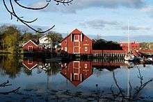
Hitra is a municipality in Trøndelag county, Norway. The municipality covers the island of Hitra and hundreds smaller islands, islets, and skerries. It is part of the Fosen region. The administrative centre of the municipality is the village of Fillan. Other villages include Andersskogan, Ansnes, Forsnes, Hestvika, Knarrlagsund, Kvenvær, Melandsjøen, Nordbotn, Sandstad, and Ulvan.
The 680-square-kilometre (260 sq mi) municipality is the 165th largest by area out of the 422 municipalities in Norway. Hitra is the 214th most populous municipality in Norway with a population of 4,659. The municipality's population density is 7.2 inhabitants per square kilometre (19/sq mi) and its population has increased by 15.7% over the last decade.[2]
Hitra is famous in Norway for its large and dense population of Red Deer (as symbolised in its coat of arms — see image right). Hitra is a member of the International Island Games Association.
General information

Hitra was established as a municipality on 1 January 1838 (see formannskapsdistrikt). On 1 January 1877, the northern district of Frøya (population: 3,949) was separated from Hitra to form a municipality of its own. On 1 January 1886, the southern and eastern parts of Hitra were separated into a new municipality of Fillan. This left Hitra with 2,241 residents. Then on 1 January 1913, the western part of Hitra was separated to form the new municipality of Kvenvær. This left Hitra with 1,439 residents. During the 1960s, there were many municipal mergers across Norway due to the work of the Schei Committee. On 1 January 1964, the municipalities of Hitra, Kvenvær, Fillan, and Sandstad were merged to form a new, larger Hitra municipality. Prior to the merger, Hitra had 1,344 residents.[3]
On 1 January 2018, the municipality switched from the old Sør-Trøndelag county to the new Trøndelag county.
On 1 January 2020, the island of Hemnskjela and the northwestern corner of the mainland municipality of Snillfjord will be merged into Hitra.[4][5]
Name
The Old Norse form of the name was Hitr. The name is probably derived from a word with the meaning "split" or "cleft" (referring to the many inlets of the island). Until 1918, the name of the island and municipality was spelled Hitteren.[6]
Coat of arms
The coat of arms is from modern times. They were granted on 7 August 1987. The arms show the head of a Red Deer in silver on a blue background. It symbolizes one of Northern Europe's largest populations of red deer which is located in the municipality.[7]
Churches
The Church of Norway has four parishes (sokn) within the municipality of Hitra. It is part of the Orkdal prosti (deanery) in the Diocese of Nidaros.
| Parish (Sokn) | Church Name | Location of the Church | Year Built |
|---|---|---|---|
| Hitra | Hitra Church | Melandsjøen | 1927 |
| Dolm Church | Dolmøya | 1188 | |
| Fillan | Fillan Church | Fillan | 1789 |
| Nordbotn Church | Nordbotn | 1900 | |
| Kvenvær | Kvenvær Church | Kvenvær | 1909 |
| Forsnes Chapel | Forsnes | 1935 | |
| Sandstad | Sandstad Church | Sandstad | 1888 |
Government
All municipalities in Norway, including Hitra, are responsible for primary education (through 10th grade), outpatient health services, senior citizen services, unemployment and other social services, zoning, economic development, and municipal roads. The municipality is governed by a municipal council of elected representatives, which in turn elect a mayor. The municipality falls under the Fosen District Court and the Frostating Court of Appeal.
Municipal council
The municipal council (Kommunestyre) of Hitra is made up of 23 representatives that are elected to four year terms. Currently, the party breakdown is as follows:[8]
| Party Name | Name in Norwegian | Number of representatives | |
|---|---|---|---|
| Labour Party | Arbeiderpartiet | 9 | |
| Progress Party | Fremskrittspartiet | 2 | |
| Conservative Party | Høyre | 2 | |
| Christian Democratic Party | Kristelig Folkeparti | 1 | |
| Green Party | Miljøpartiet De Grønne | 1 | |
| Pensioners' Party | Pensjonistpartiet | 4 | |
| Centre Party | Senterpartiet | 2 | |
| Socialist Left Party | Sosialistisk Venstreparti | 1 | |
| Liberal Party | Venstre | 1 | |
| Total number of members: | 23 | ||
Geography


Hitra is the seventh largest island of mainland Norway, and is bordered by Frøya to the north. It lies between the Trondheimsleia and the Frøyfjorden. The 345-metre (1,132 ft) tall Mørkdalstuva is the highest point on the island.
Other than the large island of Hitra, there are many other islands in the municipality, notably Fjellværsøya, Ulvøya, Dolmøya, Helgbustadøya, and Bispøyan. The Børøyholmen Lighthouse and Terningen Lighthouse are located in the Trondheimsleia in the southeast part of Hitra municipality.
Transportation
The company Kystekspressen runs westamaran services from Trondheim and Kristiansund. The 5,610-metre (3.5 mi) long undersea tunnel called the Hitratunnelen connects Hitra to the mainland to the south and the 5,305-metre (3.3 mi) long Frøya Tunnel connects Hitra to Frøya to the north.
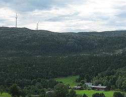
Energy
There is a wind farm in the central part of the island, Hitra Wind Farm, founded in 2004, which has 24 wind turbines which produce a total of 55 megawatts (74,000 hp).
See also
References
- ↑ "Navn på steder og personer: Innbyggjarnamn" (in Norwegian). Språkrådet. Retrieved 2015-12-01.
- ↑ Statistisk sentralbyrå (2017). "Table: 06913: Population 1 January and population changes during the calendar year (M)" (in Norwegian). Retrieved 2017-10-05.
- ↑ Jukvam, Dag (1999). "Historisk oversikt over endringer i kommune- og fylkesinndelingen" (PDF) (in Norwegian). Statistisk sentralbyrå.
- ↑ "Velkommen Snillfjordinger" (in Norwegian). Retrieved 2017-10-05.
- ↑ "Veien videre- Hitra, Snillfjord" (in Norwegian). Snillfjord kommune. Retrieved 2017-10-05.
- ↑ Rygh, Oluf (1901). Norske gaardnavne: Søndre Trondhjems amt (in Norwegian) (14 ed.). Kristiania, Norge: W. C. Fabritius & sønners bogtrikkeri. p. 63.
- ↑ "Sør-Trøndelag fylke". Retrieved 2008-10-28.
- ↑ "Table: 04813: Members of the local councils, by party/electoral list at the Municipal Council election (M)" (in Norwegian). Statistics Norway. 2015.
External links
| Wikimedia Commons has media related to Hitra. |
| Wikivoyage has a travel guide for Trøndelag. |
- Hitra Windpark (in Norwegian)
- Municipal fact sheet from Statistics Norway (in Norwegian)
| |||||||
| |||||||
| |||||||

| Authority control |
|---|