Meråker
| Meråker kommune | |||
|---|---|---|---|
| Municipality | |||
 View of the Meråker valley | |||
| |||
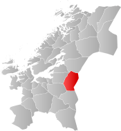 Meråker within Trøndelag | |||
| Coordinates: 63°26′17″N 11°50′58″E / 63.43806°N 11.84944°ECoordinates: 63°26′17″N 11°50′58″E / 63.43806°N 11.84944°E | |||
| Country | Norway | ||
| County | Trøndelag | ||
| District | Stjørdalen | ||
| Established | 1 Jan 1874 | ||
| Administrative centre | Midtbygda | ||
| Government | |||
| • Mayor (2015) | Kari Anita Furunes (Sp) | ||
| Area | |||
| • Total | 1,273.42 km2 (491.67 sq mi) | ||
| • Land | 1,188.28 km2 (458.80 sq mi) | ||
| • Water | 85.14 km2 (32.87 sq mi) 6.7% | ||
| Area rank | #74 in Norway | ||
| Population (2017) | |||
| • Total | 2,508 | ||
| • Rank | #296 in Norway | ||
| • Density | 2.1/km2 (5/sq mi) | ||
| • Change (10 years) | 0.0% | ||
| Demonym(s) | Meråkerbygg[1] | ||
| Time zone | UTC+01:00 (CET) | ||
| • Summer (DST) | UTC+02:00 (CEST) | ||
| ISO 3166 code | NO-5034 | ||
| Official language form | Bokmål | ||
| Website |
meraker | ||

Meråker is a municipality in Trøndelag county, Norway. It is part of the Stjørdalen region. The administrative centre of the municipality is the village of Midtbygda which is about 20 kilometres (12 mi) west of Storlien in Sweden and 46 kilometres (29 mi) east of the town of Stjørdalshalsen in neighboring Stjørdal municipality. Other villages in Meråker include Gudåa, Kopperå, and Stordalen.
The municipality markets itself as a recreational area. The main areas of employment are in industry and agriculture. The municipality is noted for its characteristic dialect.
The 1,273-square-kilometre (492 sq mi) municipality is the 74th largest by area out of the 422 municipalities in Norway. Meråker is the 296th most populous municipality in Norway with a population of 2,508. The municipality's population density is 2.1 inhabitants per square kilometre (5.4/sq mi) and its population has increased by 0.0% over the last decade.[2]
General information
The municipality of Meråker was established on 1 January 1874 when the old municipality of Øvre Stjørdal was divided into two: Hegra (population: 3,409) and Meråker (population: 1,861). The municipal borders have not changed since then.[3] On 1 January 2018, the municipality switched from the old Nord-Trøndelag county to the new Trøndelag county.
Name
The municipality (originally the parish) is named after the old Meråker farm (spelled "Mørakre" around 1430), since the first Meråker Church was built there. The meaning of the first element is uncertain (maybe merr which means "mare" or mýrr which means "bog" or "marsh") and the last element is akr which means "field" or "acre".[4]
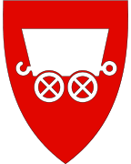
Coat of arms
The coat of arms is from modern times; they were granted on 28 September 1990. Traditionally, mining has played a major role in the area and has been of great economic importance for Meråker. Thus a silver mining cart on a red background as a symbol for the municipality was an obvious decision. The cart depicted in the arms, however, is officially described as a cart, not a mining cart.[5]
Churches
The Church of Norway has one parish (sokn) within the municipality of Meråker. It is part of the Stjørdal prosti (deanery) in the Diocese of Nidaros.
| Parish (Sokn) | Church Name | Location of the Church | Year Built |
|---|---|---|---|
| Meråker | Meråker Church | Midtbygda | 1874 |
| Kopperå Chapel | Kopperå | 1936 | |
| Stordalen Chapel | Stordalen | 1863 |
History
Meråker Smelter
In 1898, a carbide factory was opened at Kopperå, later this factor was rebuilt as a silicon smelter. The smelter was in operation until June 2006. Its main product was microsilica which is used as an additive to cement.
Geography
Meråker is a landlocked municipality in the central part of Trøndelag county. To the north is the municipality of Verdal, to the west is Stjørdal, to the south is Selbu and Tydal, and to the east is Sweden.
There are three major lakes in Meråker: Feren, Fjergen, and Funnsjøen. The river Stjørdalselva runs through the municipality towards the Trondheimsfjord. The river Rotla begins in the southern part of Meråker. The mountain Fongen sits on the southern border with Tydal and Selbu.
Government
All municipalities in Norway, including Meråker, are responsible for primary education (through 10th grade), outpatient health services, senior citizen services, unemployment and other social services, zoning, economic development, and municipal roads. The municipality is governed by a municipal council of elected representatives, which in turn elect a mayor. The municipality falls under the Inntrøndelag District Court and the Frostating Court of Appeal.
Municipal council
The municipal council (Kommunestyre) of Meråker is made up of 21 representatives that are elected to four year terms. Currently, the party breakdown is as follows:[6]
| Party Name | Name in Norwegian | Number of representatives | |
|---|---|---|---|
| Labour Party | Arbeiderpartiet | 6 | |
| Progress Party | Fremskrittspartiet | 1 | |
| Centre Party | Senterpartiet | 4 | |
| Socialist Left Party | Sosialistisk Venstreparti | 1 | |
| Liberal Party | Venstre | 3 | |
| Local Lists | Lokale lister | 6 | |
| Total number of members: | 21 | ||
Transportation
The European route E14 highway runs east to west through the municipality connecting to Trondheim Airport, Værnes about 40 kilometres (25 mi) to the west. The Meråker Line railway follows the E14 through the municipality also, with stops at Kopperå Station, Meråker Station, and Gudå Station.
Media
The newspaper Meråkerposten has been published in Meråker since 1982.[7]
Notable residents
- Helge Ingstad (1899–2001), an author, explorer, archeologist
- Magnar Lundemo (1938–1987), a cross country skier
- Frode Estil (born 1972), a cross country skier
- Tora Berger (born 1981), a biathlete and Olympic champion
References
- ↑ "Navn på steder og personer: Innbyggjarnamn" (in Norwegian). Språkrådet. Retrieved 2015-12-01.
- ↑ Statistisk sentralbyrå (2017). "Table: 06913: Population 1 January and population changes during the calendar year (M)" (in Norwegian). Retrieved 2017-10-01.
- ↑ Jukvam, Dag (1999). "Historisk oversikt over endringer i kommune- og fylkesinndelingen" (PDF) (in Norwegian). Statistisk sentralbyrå.
- ↑ Rygh, Oluf (1903). Norske gaardnavne: Nordre Trondhjems amt (dokpro.uio.no) (in Norwegian) (15 ed.). Kristiania, Norge: W. C. Fabritius & sønners bogtrikkeri. p. 2.
- ↑ Norske Kommunevåpen (1990). "Nye kommunevåbener i Norden". Retrieved 8 November 2008.
- ↑ "Table: 04813: Members of the local councils, by party/electoral list at the Municipal Council election (M)" (in Norwegian). Statistics Norway. 2015.
- ↑ Smith-Meyer, Trond, ed. (2016-12-01). "Meråkerposten". Store norske leksikon (in Norwegian). Kunnskapsforlaget. Retrieved 2018-03-24.
External links
| Wikimedia Commons has media related to Meråker. |

- Municipal fact sheet from Statistics Norway (in Norwegian)
- Meråker Municipality Website (in Norwegian)
- Meråker Tourism Website (in Norwegian)
- Industrial Museum at Kopperå (in Norwegian)
- Map of Cultural Sites in Meråker (in Norwegian)
- Meråker Elementary School (in Norwegian)
- Lauvlimoen Biathlon team (in Norwegian)
| |||||||
| |||||||
| |||||||

| Authority control |
|---|