Namsos
| Namsos kommune | |||
|---|---|---|---|
| Municipality | |||
 | |||
| |||
 Namsos within Trøndelag | |||
| Coordinates: 64°29′38″N 11°30′42″E / 64.49389°N 11.51167°ECoordinates: 64°29′38″N 11°30′42″E / 64.49389°N 11.51167°E | |||
| Country | Norway | ||
| County | Trøndelag | ||
| District | Namdalen | ||
| Established | 1846 | ||
| Administrative centre | Namsos | ||
| Government | |||
| • Mayor (2007) | Arnhild Holstad (Ap) | ||
| Area | |||
| • Total | 778.61 km2 (300.62 sq mi) | ||
| • Land | 751.16 km2 (290.02 sq mi) | ||
| • Water | 27.45 km2 (10.60 sq mi) 3.5% | ||
| Area rank | #143 in Norway | ||
| Population (2017) | |||
| • Total | 13,051 | ||
| • Rank | #91 in Norway | ||
| • Density | 17.4/km2 (45/sq mi) | ||
| • Change (10 years) | 3.8% | ||
| Demonym(s) | Namsosing[1] | ||
| Time zone | UTC+01:00 (CET) | ||
| • Summer (DST) | UTC+02:00 (CEST) | ||
| ISO 3166 code | NO-5005 | ||
| Official language form | Neutral | ||
| Website |
namsos | ||

![]()
The 779-square-kilometre (301 sq mi) municipality is the 143rd largest by area out of the 422 municipalities in Norway. Namsos is the 91st most populous municipality in Norway with a population of 13,051. The municipality's population density is 17.4 inhabitants per square kilometre (45/sq mi) and its population has increased by 3.8% over the last decade.[2]
General information

Name
The first part of the name comes from the local river Namsen. The last element is os, which means the "mouth of a river".[3]
Coat of arms
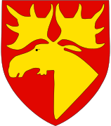
The coat of arms is from modern times; they were granted on 5 May 1961. They were re-granted on 21 October 1966 when the town was annexed by Namsos. The arms show a golden moose head[4] on a red background. The moose was chosen as a symbol for the municipality, since Namsos is the capital of the forest-rich Namdalen region, and the moose is the "king of the forest".[3][5]
Churches
The Church of Norway has four parishes (sokn) within the municipality of Namsos. It is part of the Namdal prosti (deanery) in the Diocese of Nidaros.
| Parish (Sokn) | Church Name | Location of the Church | Year Built |
|---|---|---|---|
| Klinga | Klinga Church | Klinga | 1866 |
| Namsos | Namsos Church | town of Namsos | 1960 |
| Otterøy | Otterøy Church | Skomsvoll | 1858 |
| Vemundvik | Vemundvik Church | Vemundvik | 1875 |
History
On 1 January 1838, the parish of Vemundvik was established as a municipality (see formannskapsdistrikt). In 1846, the village of Namsos in Vemundvik was established as a ladested. Namsos was located at the mouth of the Namsen river in the Sævik area of Vemundvik. The new ladested (town) was established as its own municipality, with 591 inhabitants. This left Vemundvik with 908 residents.[6][7]
In 1865, the town of Namsos also became a parish in the Church of Norway. It had been decided to build a church in the city in March 1859; the construction was finished in November. In May 1865, the parish was created, with the sub-parishes of Sævik and Vemundvik, formerly within Overhalla parish, was incorporated into Namsos' parish limits.[8]
Areas of Vemundvik lying adjacent to the town of Namsos were later incorporated within the city limits on numerous occasions. On 1 January 1882, an area with 109 inhabitants was moved to the town; on 1 July 1921 an area with 927 inhabitants; and on 1 July 1957, another area with a population of 6.
During the 1960s, there were many municipal mergers across Norway due to the work of the Schei Committee. On 1 January 1964, the size of Namsos was significantly increased as the neighboring municipalities of Vemundvik (population: 2,040) and Klinga (population: 2,482) were incorporated into the town of Namsos (population: 5,224). On the same date, the northern part of the neighboring municipality of Otterøy (population: 1,013), and the Finnanger area of Fosnes municipality (population: 116) were also incorporated into Namsos. Namsos, which previously had a population of 5,224, had its size increased to 10,875 inhabitants.[6]
Consisting mostly of wooden houses, it has been burned down to the ground on three occasions during its relatively short history. The first fire was in 1872, caused by two boys playing with matches. The second fire was in 1897, from an unknown cause. The third time was during World War II when the town was bombed by German airplanes on 20 April 1940.[3]
The location by the river and the large forests nearby made the town ideal for sawmills. There were eleven mills in their heyday, but only one remains: Moelven Van Severen. In addition, the Norwegian Sawmill Museum is located at Spillum just south of the town. The museum is located at the now closed and restored Spillum Dampsag & Hovleri sawmill from 1884. The town has a swimming pool, Oasen, built inside a mountain.
On 16 June 2016, the three neighboring municipalities of Fosnes, Namsos, and Namdalseid voted to merge into a new, larger municipality that will be called Namsos starting on 1 January 2020 as part of a large municipal reform across Norway.[9]
On 1 January 2018, the municipality switched from the old Nord-Trøndelag county to the new Trøndelag county.
Geography
The town is located on a small bay, about 15 miles (24 km) from the sea, near the head of Namsenfjorden and at the mouth of the river Namsen, one of the richest salmon rivers in Europe]. The municipality also includes the islands of Otterøya and Hoddøya as well as the southwestern half of Elvalandet island.
The main part of the town is built on a small, low-lying promontory which extends into the bay. To the north, low forested hills rise fairly steeply to over 200 metres (660 ft). There is a viewpoint from the hills above the city which is called Klompen with a height of 114 metres (374 ft) with a road for cars up to the top that is open each summer. To the east extends the wide Namdalen valley. To the south over the bay and mouth of the river Namsen are hills that reach 440 metres (1,440 ft).
Climate
The climate is generally maritime. The average temperature in January is −2.4 °C (27.7 °F), in July it is 13.3 °C (55.9 °F). The mean annual temperature is 5 °C (41 °F) and the annual precipitation is 1,340 millimetres (53 in).[10]
Government
All municipalities in Norway, including Namsos, are responsible for primary education (through 10th grade), outpatient health services, senior citizen services, unemployment and other social services, zoning, economic development, and municipal roads. The municipality is governed by a municipal council of elected representatives, which in turn elect a mayor. The municipality falls under the Namdal District Court and the Frostating Court of Appeal.
Municipal council
The municipal council (Kommunestyre) of Namsos is made up of 27 representatives that are elected to four year terms. Currently, the party breakdown is as follows:[11]
| Party Name | Name in Norwegian | Number of representatives | |
|---|---|---|---|
| Labour Party | Arbeiderpartiet | 13 | |
| Progress Party | Fremskrittspartiet | 2 | |
| Conservative Party | Høyre | 4 | |
| Christian Democratic Party | Kristelig Folkeparti | 1 | |
| Centre Party | Senterpartiet | 2 | |
| Socialist Left Party | Sosialistisk Venstreparti | 3 | |
| Liberal Party | Venstre | 2 | |
| Total number of members: | 27 | ||
Transportation
Namsos Airport is located just outside the town of Namsos, around 3 km from the city, with direct flights to Oslo, Trondheim, Rørvik, Mosjøen, Bodø. Norwegian County Road 17 runs through part of the municipality.
The closed Namsos Line runs from Namsos to Grong. The island of Otterøya is connected to the mainland via the Lokkaren Bridge.
Media gallery

 View of the town from the fjord
 Sawmill Museum
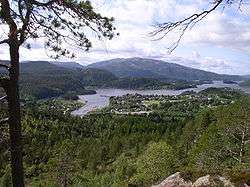 View of Bangsund
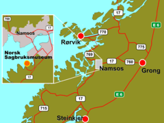 Map of the area
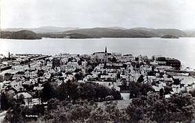 View of the town in 1935
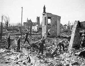 View of the town in 1940 after the German bombing
References
- ↑ "Navn på steder og personer: Innbyggjarnamn" (in Norwegian). Språkrådet. Retrieved 2015-12-01.
- ↑ Statistisk sentralbyrå (2017). "Table: 06913: Population 1 January and population changes during the calendar year (M)" (in Norwegian). Retrieved 2017-09-25.
- 1 2 3 Store norske leksikon. "Namsos" (in Norwegian). Retrieved 2011-08-24.
- ↑ Moose Heads in heraldry.
- ↑ Norske Kommunevåpen (1990). "Nye kommunevåbener i Norden". Retrieved 13 November 2008.
- 1 2 Jukvam, Dag (1999). "Historisk oversikt over endringer i kommune- og fylkesinndelingen" (PDF) (in Norwegian). Statistisk sentralbyrå.
- ↑ Thorsnæs, Geir, ed. (2017-11-14). "Vemundvik – tidligere kommune". Store norske leksikon (in Norwegian). Kunnskapsforlaget. Retrieved 2018-04-18.
- ↑ "Namsos" (in Norwegian). DIS-Norge. Retrieved 2011-08-22.
- ↑ "Om nye Namsos" (in Norwegian). NyeNamsos.no. Retrieved 2017-09-25.
- ↑ "Temperaturnormaler for Namsos i perioden 1961 - 1990" (in Norwegian). met.no. Archived from the original on 2012-07-20. Retrieved 2008-11-13.
- ↑ "Table: 04813: Members of the local councils, by party/electoral list at the Municipal Council election (M)" (in Norwegian). Statistics Norway. 2015.
External links
| Wikimedia Commons has media related to Namsos. |

- Municipal fact sheet from Statistics Norway (in Norwegian)
- Oasen Swimming Pool (in Norwegian)
- Avinor: Picture showing Namsos Airport and Namsos
| |||||||
| |||||||
| |||||||
