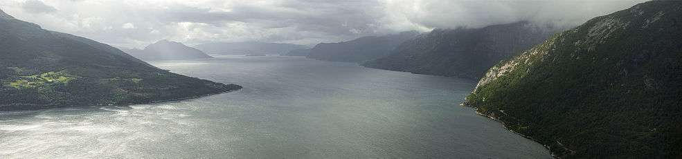
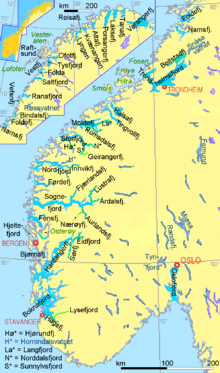
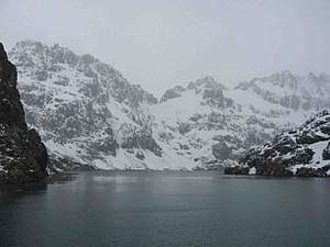
Fjord
.jpg)
Geologically, a fjord or fiord (/ˈfjɔːrd/ (![]()
![]()
Formation
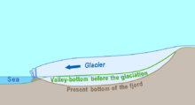
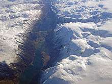
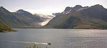
A true fjord is formed when a glacier cuts a U-shaped valley by ice segregation and abrasion of the surrounding bedrock.[6] According to the standard model, glaciers formed in pre-glacial valleys with a gently sloping valley floor. The work of the glacier then left an overdeepened U-shaped valley that ends abruptly at a valley or trough end. Such valleys are fjords when flooded by the ocean. Thresholds above sea level create freshwater lakes.[7] Glacial melting is accompanied by the rebounding of Earth's crust as the ice load and eroded sediment is removed (also called isostasy or glacial rebound). In some cases this rebound is faster than sea level rise. Most fjords are deeper than the adjacent sea; Sognefjord, Norway, reaches as much as 1,300 m (4,265 ft) below sea level. Fjords generally have a sill or shoal (bedrock) at their mouth caused by the previous glacier's reduced erosion rate and terminal moraine.[8] In many cases this sill causes extreme currents and large saltwater rapids (see skookumchuck). Saltstraumen in Norway is often described as the world's strongest tidal current. These characteristics distinguish fjords from rias (e.g. the Bay of Kotor), which are drowned valleys flooded by the rising sea. Drammensfjorden is cut almost in two by the Svelvik "ridge", a sandy moraine that during the ice cover was under sea level but after the post-glacial rebound reaches 60 meters above the fjord.[9]
Jens Esmark in the 19th century introduced the theory that fjords are or have been created by glaciers and that large parts of Northern Europe had been covered by thick ice in prehistory.[10] Thresholds at the mouths and overdeepening of fjords compared to the ocean are the strongest evidence of glacial origin,[11] and these thresholds are mostly rocky. Thresholds are related to sounds and low land where the ice could spread out and therefore have less erosive force. John Walter Gregory argued that fjords are of tectonic origin and that glaciers had a negligible role in their formation. Gregory's views were rejected by subsequent research and publications. In the case of Hardangerfjord the fractures of the Caledonian fold has guided the erosion by glaciers, while there is no clear relation between the direction of Sognefjord and the fold pattern.[10] This relationship between fractures and direction of fjords is also observed in Lyngen.[12] Preglacial, tertiary rivers presumably eroded the surface and created valleys that later guided the glacial flow and erosion of the bedrock. This may in particular have been the case in Western Norway where the tertiary uplift of the landmass amplified eroding forces of rivers.[10]
Confluence of tributatry fjords led to excavation of the deepest fjord basins. Near the very coast the typical West Norwegian glacier spread out (presumably through sounds and low valleys) and lost their concentration and reduced the glaciers' power to erode leaving bedrock thresholds. Bolstadfjorden is 160 meters deep with a treshold of only 1.5 meters,[10][7] while the 1300 meter deep Sognefjorden has a treshold around 100 to 200 meters deep.[13][14] Hardangerfjord is made up of several basins separated by thresholds: The deepest basin Samlafjorden between Jonaneset (Jondal) og Ålvik with a distinct treshold at Vikingneset in Kvam.[10]
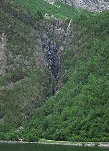
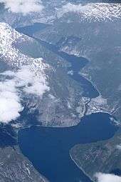
Hanging valleys are common along glaciated fjords and U-shaped valleys. A hanging valley is a tributary valley that is higher than the main valley and were created by tributary glacier flows into a glacier of larger volume. The shallower valley appears to be 'hanging' above the main valley or a fjord. Often, waterfalls form at or near the outlet of the upper valley.[15] Hanging valleys also occur under water in fjord systems. The branches of Sognefjord are for instance much shallower than the main fjord. The mouth of Fjærlandsfjord is about 400 meters deep while the main fjord is 1200 meters nearby. The mouth of Ikjefjord is only 50 meters deep while the main fjord is around 1300 meters at the same point.[11]
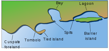
Fjord features and variations
Hydrology
During the winter season there is usually little inflow of freshwater. Surface water and deeper water (down to 100 meters or more) are mixed during winter because of the steady cooling of the surface and wind. In the deep fjords there is still fresh water from the summer with less density than the saltier water along the coast. Offshore wind, common in the fjord areas during winter, sets up a current on the surface from the inner to the outer parts. This current on the surface in turn pulls dense salt water from the coast across the fjord threshold and into the deepest parts of the fjord.[16] Bolstadfjorden has a threshold of only 1.5 meters and strong inflow of freshwater from Vosso river creates a brackish surface that blocks circulation of the deep fjord. The deeper, salt layers of Bolstadfjorden are deprived of oxygen and the seabed is covered with organic material. The shallow threshold also creates a strong tidal current.[7]
During the summer season there is usually a large inflow of river water in the inner areas. This freshwater gets mixed with saltwater creating a layer of brackish water with a slightly higher surface than the ocean which in turn sets up a current from the river mouths towards the ocean. This current is gradually more salty towards the coast and right under the surface current there is a reverse current of saltier water from the coast. In the deeper parts of the fjord the cold water remaining from winter is still and separated from the atmosphere by the brackish top layer. In fjords with a shallow threshold this deep water is not replaced every year and low oxygen concentration makes the deep water unsuitable for fish and animals. In the most extreme cases there is a constant barrier of freshwater on the surface and the fjord freezes over such that there is no oxygen below the surface. Drammensfjorden is one example.[16]
The Gaupnefjorden branch of Sognefjorden is strongly affected by freshwater as a glacial river flows in. Velfjorden has little inflow of freshwater.[17]
Coral reefs
As late as 2000, some coral reefs were discovered along the bottoms of the Norwegian fjords.[18] These reefs were found in fjords from the north of Norway to the south. The marine life on the reefs is believed to be one of the most important reasons why the Norwegian coastline is such a generous fishing ground. Since this discovery is fairly new, little research has been done. The reefs are host to thousands of lifeforms such as plankton, coral, anemones, fish, several species of shark, and many more. Most are specially adapted to life under the greater pressure of the water column above it, and the total darkness of the deep sea.[19]
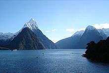
New Zealand's fjords are also host to deep-water corals, but a surface layer of dark fresh water allows these corals to grow in much shallower water than usual. An underwater observatory in Milford Sound allows tourists to view them without diving.[20]
Skerries
In some places near the seaward margins of areas with fjords, the ice-scoured channels are so numerous and varied in direction that the rocky coast is divided into thousands of island blocks, some large and mountainous while others are merely rocky points or rock reefs, menacing navigation. These are called skerries.[19] The term skerry is derived from the Old Norse sker, which means a rock in the sea.[21]
Skerries most commonly formed at the outlet of fjords where submerged glacially formed valleys perpendicular to the coast join with other cross valleys in a complex array. The island fringe of Norway is such a group of skerries (called a skjærgård); many of the cross fjords are so arranged that they parallel the coast and provide a protected channel behind an almost unbroken succession of mountainous islands and skerries. By this channel one can travel through a protected passage almost the entire 1,601 km (995 mi) route from Stavanger to North Cape, Norway. The Blindleia is a skerry-protected waterway that starts near Kristiansand in southern Norway, and continues past Lillesand. The Swedish coast along Bohuslän is likewise skerry guarded. The Inside Passage provides a similar route from Seattle, Washington, and Vancouver, British Columbia, to Skagway, Alaska. Yet another such skerry protected passage extends from the Straits of Magellan north for 800 km (500 mi).
Epishelf lakes
An epishelf lake forms when meltwater is trapped behind a floating ice shelf and the freshwater floats on the denser saltwater below. Its surface may freeze forming an isolated ecosystem.
Etymology
The word fjord comes from Norwegian (pronounced [ˈfjuːr], [ˈfjøːr], [ˈfjuːɽ] or [ˈfjøːɽ] in various dialects), where it can have a more general meaning: in many cases to refer to any long narrow body of water, inlet or channel (for example, see Oslofjord).
The Norse verb ferd (travelling/ferrying), the Norse noun substantive fjǫrðr means a "lake-like" waterbody used for passage and ferrying, which is of Indo-European origin (*prtús from *por- or *per).[22]
The Scandinavian fjord, Proto-Scandinavian *ferþuz, is the origin for similar Germanic words: Icelandic fjörður, Swedish fjärd (for Baltic waterbodies), Scots firth.[22] The Norse noun fjǫrðr was adopted in German as Förde, used for the narrow long bays of Schleswig-Holstein, and in English as firth "fjord, river mouth". The English word ford (compare German Furt, Low German Ford or Vörde, in Dutch names voorde such as Vilvoorde, Ancient Greek πόρος, poros, and Latin portus) is assumed to originate from Germanic *ferþu- and Indo-European root *pertu- meaning "crossing point". Fjord/firth/Förde as well as ford/Furt/Vörde/voorde refer to a Germanic noun for a travel: North Germanic ferd or färd and of the verb to travel, Dutch varen, German fahren; English to fare.[23]
As a loanword from Norwegian, it is one of the few words in the English language to start with the sequence fj.[24] The word was for a long time normally rendered fiord,[25] a spelling preserved in place names such as Grise Fiord, but now generally current only in New Zealand English.
Scandinavian usage
The use of the word fjord in Norwegian, Danish and Swedish is more general than in English and in international scientific terminology. In Scandinavia, fjord is used for a narrow inlet of the sea in Norway, Denmark and western Sweden, but this is not its only application. In Norway and Iceland, the usage is closest to the Old Norse, with fjord used for both a firth and for a long, narrow inlet. In eastern Norway, the term is also applied to long narrow freshwater lakes (for instance Mjøsa [commonly referred to as fjorden], Randsfjorden and Tyrifjorden) and sometimes even to rivers (in local usage, for instance in Flå in Hallingdal, the Hallingdal river is referred to as fjorden). In southeast Sweden, the name fjard fjärd is a subdivision of the term 'fjord' used for bays, bights and narrow inlets on the Swedish Baltic Sea coast, and in most Swedish lakes. This latter term is also used for bodies of water off the coast of Finland where Finland Swedish is spoken. In Danish, the word may even apply to shallow lagoons. In modern Icelandic, fjörður is still used with the broader meaning of firth or inlet. In Faroese fjørður is used both about inlets and about broader sounds, whereas a narrower sound is called sund. In the Finnish language, a word vuono is used although there is only one fjord in Finland. Small waterfalls within these fjords are also used as freshwater resources for the people of Scandinavia and, in particular, Norway.
In old Norse genitive was fjarðar whereas dative was firði. The dative form has become common place names like Førde (for instance Førde), Fyrde or Førre (for instance Førre).[26]
The German use of the word Föhrde for long narrow bays on their Baltic Sea coastline, indicates a common Germanic origin of the word. The landscape consists mainly of moraine heaps. The Föhrden and some "fjords" on the east side of Jutland, Denmark are also of glacial origin. But while the glaciers digging "real" fjords moved from the mountains to the sea, in Denmark and Germany they were tongues of a huge glacier covering the basin of which is now the Baltic Sea. See Förden and East Jutland Fjorde.
Whereas fjord names mostly describe bays (though not always geological fjords), straits in the same regions typically are named Sund, in Scandinavian languages as well as in German. The word is related to "to sunder" in the meaning of "to separate". So the use of Sound to name fjords in North America and New Zealand differs from the European meaning of that word.
The name of Wexford in Ireland is originally derived from Veisafjǫrðr ("inlet of the mud flats") in Old Norse, as used by the Viking settlers—though the inlet at that place in modern terms is an estuary, not a fjord.
Before or in the early phase of Old Norse angr was another common noun for fjords and other inlets of the ocean. This word has survived only as a suffix in names of some Scandinavian fjords and has in same cases also been transferred to adjacent settlements or surrounding areas for instance Hardanger, Stavanger and Geiranger.[27][28]
Differences in definitions
The differences in usage between the English and the Scandinavian languages have contributed to confusion in the use of the term fjord. Bodies of water that are clearly fjords in Scandinavian languages are not considered fjords in English; similarly bodies of water that would clearly not be fjords in the Scandinavian sense have been named or suggested to be fjords. Examples of this confused usage follow.
The Bay of Kotor in Montenegro has been suggested by some to be a fjord, but is in fact a drowned river canyon or ria. Similarly the Lim bay in Istria, Croatia, is sometimes called "Lim fjord" although it was not carved by glacial erosion but instead is a ria dug by the river Pazinčica. The Croats call it Limski kanal, which does not translate precisely to the English equivalent either.
In the Danish language any inlet is called a fjord, but none of the fjords of Denmark may be considered a fjord in the geological sense. Limfjord in English terminology is a sound, since it separates the North Jutlandic Island (Vendsyssel-Thy) from the rest of Jutland. Ringkøbing Fjord on the western coast of Jutland is a lagoon. The long narrow fjords of Denmark's Baltic Sea coast like the German Förden were dug by ice moving from the sea upon land, while fjords in the geological sense were dug by ice moving from the mountains down to the sea.
The fjords in Finnmark (Norway), which are fjords in the Scandinavian sense of the term, are not universally considered to be fjords by the scientific community.[29] Although glacially formed, most Finnmark fjords lack the steep-sided valleys of the more southerly Norwegian fjords since the glacial pack was deep enough to cover even the high grounds when they were formed. The Oslofjord on the other hand is a rift valley, and not glacially formed.
In Acapulco, Mexico, the calanques—narrow, rocky inlets—on the western side of the city, where the famous cliff-divers perform daily, are described in the city's tourist literature as being fjords.
Freshwater fjords
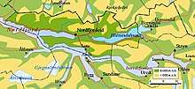
Some Norwegian freshwater lakes that have formed in long glacially carved valleys with sill thresholds, ice front deltas or terminal moraines blocking the outlet follow the Norwegian naming convention; they are frequently named fjords. Ice front deltas developed when the ice front was relatively stable for long time during the melting of the ice shield. The resulting landform is an isthmus between the lake and the saltwater fjord, in Norwegian called "eid" as in placename Eidfjord or Nordfjordeid. The post-glacial rebound changed these deltas into terraces up to the level of the original sea level. In Eidfjord, Eio has dug through the original delta and left a terrace 110 meter while lake is only 19 meters above sea level.[30][31] Such deposits are valuable sources of high quality building materials (sand and gravel) for houses and infrastructure.[32] Eidfjord village sits on the eid or isthmus between Eidfjordvatnet lake and Eidfjorden branch of Hardangerfjord.[33] Nordfjordeid is the isthmus with a village between Hornindalsvatnet lake and Nordfjord.[34][35] Such lakes are also denoted fjord valley lakes by geologists.[36]
One of Norway's largest is Tyrifjorden at 63 meters above sea level and an average depth at 97 meters most of the lake is under sea level. Norway's largest lake, Mjøsa, is also referred to as "the fjord" by locals.[31] Another example is the freshwater fjord Movatnet (Mo lake) that until 1743 was separated from Romarheimsfjorden by an isthmus and connected by a short river. During a flood in November 1743 the river bed eroded and sea water could flow into the lake at high tide. Eventually Movatnet became a saltwater fjord and renamed Mofjorden (Mofjorden).[37] Like fjords, freshwater lakes are often deep. For instance Hornindalsvatnet is at least 500 meters deep and water takes an average of 16 years to flow through the lake.[38] Such lakes created by glacial action are also called fjord lakes or moraine-dammed lakes.[39]
Some of these lakes were salt after the ice age but later cut off from the ocean during the post-glacial rebound.[17] At the end of the ice age Eastern Norway was about 200 meters lower (the marine limit). When the ice cap receded and allowed the ocean to fill valleys and lowlands, and lakes like Mjøsa and Tyrifjorden were part of the ocean while Drammen valley was a narrow fjord. At the time of the Vikings Drammensfjord was still 4 or 5 meters higher than today and reached the town of Hokksund, while parts of what is now the city of Drammen was under water.[40] After the ice age the ocean was about 150 meter at Notodden. The ocean stretched like a fjord through Heddalsvatnet all the way to Hjartdal. Post-glacial rebound eventually separated Heddalsvatnet from the ocean and turned it into a freshwater lake.[41][42] In neolithic times Heddalsvatnet was still a saltwater fjord connected to the ocean, and was cut off from the ocean around 1500 BC.[43]
Some salt water fish got trapped in lakes that originally were part of the salt fjord and gradually became freshwater fish such as the arctic char.[44] Some freshwater fjords such as Slidrefjord are above the marine limit.
Like freshwater fjords, the continuation of fjords on land are in the same way denoted as fjord-valleys. For instance Flåmsdal (Flåm valley) and Måbødalen.[10][45][46]
Outside of Norway, the three western arms of New Zealand's Lake Te Anau are named North Fiord, Middle Fiord and South Fiord. Another freshwater "fjord" in a larger lake is Western Brook Pond, in Newfoundland's Gros Morne National Park; it is also often described as a fjord, but is actually a freshwater lake cut off from the sea, so is not a fjord in the English sense of the term. Locally they refer to it as a "landlocked fjord". Such lakes are sometimes called "fjord lakes". Okanagan Lake was the first North American lake to be so described, in 1962.[47] The bedrock there has been eroded up to 650 m (2,133 ft) below sea level, which is 2,000 m (6,562 ft) below the surrounding regional topography.[48] Fjord lakes are common on the inland lea of the Coast Mountains and Cascade Range; notable ones include Lake Chelan, Seton Lake, Chilko Lake, and Atlin Lake. Kootenay Lake, Slocan Lake and others in the basin of the Columbia River are also fjord-like in nature, and created by glaciation in the same way. Along the British Columbia Coast, a notable fjord-lake is Owikeno Lake, which is a freshwater extension of Rivers Inlet. Quesnel Lake, located in central British Columbia, is claimed to be the deepest fjord formed lake on Earth.
Great Lakes
A unique family of freshwater fjords are the embayments of the North American Great Lakes. Baie Fine is located on the northwestern coast of Georgian Bay of Lake Huron in Ontario, and Huron Bay is located on the southern shore of Lake Superior in Michigan.
Locations

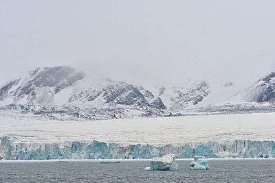
The principal mountainous regions where fjords have formed are in the higher middle latitudes and the high latitudes reaching to 80°N (Svalbard, Greenland), where, during the glacial period, many valley glaciers descended to the then-lower sea level. The fjords develop best in mountain ranges against which the prevailing westerly marine winds are orographically lifted over the mountainous regions, resulting in abundant snowfall to feed the glaciers. Hence coasts having the most pronounced fjords include the west coast of Norway, the west coast of North America from Puget Sound to Alaska, the southwest coast of New Zealand, and the west and to south-western coasts of South America, for example in Chile.
Principal glaciated regions
- West coast of Europe
- Faroe Islands
- Westfjords of Iceland
- Eastern Region of Iceland
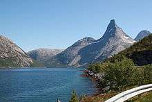
- Norway, the whole coast including Svalbard
- Kola Peninsula in Russia
- West coast of New Zealand
- Fiordland, in the southwest of the South Island
- Northwest coast of North America
- Coast of Alaska, United States: Lynn Canal, Glacier Bay, etc.
- British Columbia Coast, Canada: from the Alaskan Border along the Portland Canal to Indian Arm; Kingcome Inlet is a typical West Coast fjord.
- Hood Canal in Washington, United States and various of the sidewaters of Puget Sound
- Northeast coast of North America
- Labrador: Saglek Fjord, Nachvak Fjord, Hebron Fjord
- The east coast of Ungava Bay.
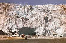
- Greenland: Kangerlussuaq, Ilulissat Icefjord, Scoresby Sund
- Saguenay Fjord, Quebec[49]
- Chile
- Western Patagonia, Chile
Other glaciated or formerly glaciated regions
Other regions have fjords, but many of these are less pronounced due to more limited exposure to westerly winds and less pronounced relief. Areas include:
- Europe
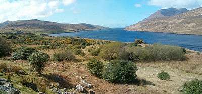
- Ireland
- Russia (see also List of fjords of Russia)
- Scotland (where they are called firths, the Scots language cognate of fjord; lochs or sea lochs). Notable examples are:
- Loch Long
- Loch Fyne, Scotland's longest fjord at 65 km
- Loch Etive
- Sweden
- Gullmarsfjorden, in Bohuslän, Sweden
- North America
- Canada:
- the west and south coasts of Newfoundland, particularly:
- Facheux Bay
- Bonne Bay in Gros Morne National Park
- Aviron Bay
- La Hune Bay
- Bay de Vieux
- White Bear Bay
- Baie d'Espoir
- La Poile Bay
- Bay Le Moine
- the Canadian Arctic Archipelago, particularly:
- the west and south coasts of Newfoundland, particularly:
- Greenland
- Scoresby Sund, the largest fjord in the world
- Søndre Strømfjord or Kangerlussuaq
- Disko Island
- Ilulissat Icefjord, the most productive ice fjord in the world.
- United States:
- Somes Sound, Acadia National Park, Maine
- Hudson River
- most clearly seen at The Palisades
- Puget Sound
- Canada:
- South America
- Chile:
- Arctic
- Antarctica
- South Georgia (UK)
- Kerguelen Islands (France)
- particularly the Antarctic Peninsula
- Sub-Antarctic islands
Extreme fjords
The longest fjords in the world are:
- Scoresby Sund in Greenland—350 km (217 mi)[50][51]
- Greely Fiord/Tanquary Fiord in Canada—230 km (143 mi) The length of the total fjord system from the head of Tanquary Sound, through Greely Fjord, to the mouth of Nansen Sound is approximately 400 km, making it arguably the longest fjord in the world.
- Sognefjord in Norway—204 km (127 mi)[52]
- Independence Fjord in Greenland—200 km (124 mi)
- Matochkin Shar, Novaya Zemlya, Russia—125 km (78 mi) (a strait with a fjord structure)[53]
Deep fjords include:
- Skelton Inlet in Antarctica—1,933 m (6,342 ft)
- Sognefjord in Norway—1,308 m (4,291 ft)[54][52] (the mountains then rise to up to 1,500 m (4,921 ft) and more, Hurrungane reaches 2,400 m (7,874 ft))[55]
- Messier Channel in Tortel, Chile—1,358 m (4,455 ft)
- Baker Channel in Tortel, Chile—1,251 m (4,104 ft)
See also
Notes
- ↑ "Fjord – Definition of fjord by Merriam-Webster". merriam-webster.com.
- ↑ "What is a Fjord, and how is it formed... - Norway Today". Norway Today. 2016-05-08. Retrieved 2017-12-30.
- ↑ Syvitsky, James P. M.; Burrell, David C.; Skei, Jens M. (1987). Fjords: Processes and Products. New York: Springer. pp. 46–49. ISBN 0-387-96342-1.
The NE coast, from Victoria Fjord to the Scoresby Sund fjord complex ..., has approximately 50 major fjords, some of them the world's largest and deepest. ... The SE coast, from Scoresby Sund to Kap Farvel ..., has approximately 100 fjords.
- ↑ "Geografiske forhold (Geography of Norway)". Statistics Norway. Retrieved 24 March 2016.
- ↑ Gregory, J.W. (1913). The Nature and Origin of Fiords. London: John Murray.
- ↑ Murton, Julian B.; Peterson, Rorik; Ozouf, Jean-Claude (17 November 2006). "Bedrock Fracture by Ice Segregation in Cold Regions" (PDF). Science. 314 (5802): 1127–1129. Bibcode:2006Sci...314.1127M. doi:10.1126/science.1132127. PMID 17110573.
- 1 2 3 Aarseth, I., Nesje, A., & Fredin, O. (2014). West Norwegian fjords. Geological Society of Norway (NGF) , Trondheim, 2014. ISBN 978-82-92-39491-5
- ↑ Alley, R.B.; D. E. Dawson; G. J. Larson; E. B. Evenson; G. S. Baker (14 August 2003). "Stabilizing feedbacks in glacier-bed erosion". Nature. Nature PublishingGroup. 424 (6950): 758–760. Bibcode:2003Natur.424..758A. doi:10.1038/nature01839. PMID 12917679.
- ↑ Jørgensen, Per: Kvartærgeologi. Landbruksforlaget, 1995.
- 1 2 3 4 5 6 Holtedahl, H. (1967). Notes on the formation of fjords and fjord-valleys. Geografiska Annaler. Series A. Physical Geography, 49(2/4): 188-203.
- 1 2 Nesje, A., & Whillans, I. M. (1994). Erosion of Sognefjord, Norway. Geomorphology, 9(1), 33-45.
- ↑ Randall, B. A. O. (1961). On the relationship of valley and fjord directions to the fracture pattern of Lyngen, Troms N. Norway. Geografiska Annaler, 43(3/4), 336-338.
- ↑ Geografisk leksikon, edited by Waldemar Brøgger. Oslo: Cappelen, 1963.
- ↑ https://snl.no/Sognefjorden
- ↑ "Glossary of Glacier Terminology". U.S. Geological Survey. May 28, 2004. Retrieved 2007-05-24.
- 1 2 Skreslet, Stig (1980). Fjordene og kyststrømmen. Rauma/Ulvåa på vektskåla. Åndalsnes: Møre og Romsdal naturvern. pp. 48–54.
- 1 2 "Fjord". Norwegian Biodiversity Information Centre. Archived from the original on 3 February 2016. Retrieved 30 January 2016.
- ↑ Institute of Marine Research: Coral reefs in Norway Archived 2008-10-11 at the Wayback Machine.
- 1 2 "Fjord". National Geographic. Retrieved April 24, 2015.
- ↑ Paddy Ryan. Fiords – Underwater rock walls and basins, Te Ara – the Encyclopedia of New Zealand. Updated 21 September 2007. Accessed 2008-04-18.
- ↑ Moore 1890, p. 277.
- 1 2 3 Store norske leksikon – Fjord, snl.no
- ↑ de Caprona, Yann (2014). Norsk etymologisk ordbok. Kagge. ISBN 978-8-2489-1054-1.
- ↑ fjeld is another
- ↑ In 1926 the A Dictionary of Modern English Usage said: "The OED gives precedence to fi-. The other spelling is apparently used in English to help the ignorant to call it fyord; as, instead of helping, it only puzzles them, it should be abandoned"
- ↑ Rygh, O. (1898). Norske Gaardnavne: Oplysninger samlede til Brug ved Matrikelens Revision. Kristiania: Fabritius.
- ↑ Rygh, O. (1896). Norske Fjordnavne. Kristiania: Aschehoug.
- ↑ Helle, Knut (1975). Stavanger: fra våg til by. Stavanger: Stabenfeldt. ISBN 8253201893.
- ↑ Bird, E.C.F. (2008) Coastal Geomorphology: An Introduction, 2nd ed. John Wiley and Sons Ltd. West Sussex, England. ISBN 978-0-470-51729-1
- ↑ Geografi: landskap, ressursar, menneske, miljø. Oslo: Cappelen, 1999. ISBN 8202173078.
- 1 2 Gustav Indrebø (1924): Norske innsjønavn: Upplands fylke. Skrifter (Videnskabsselskapet i Kristiania), Historisk-filosofisk klasse.
- ↑ Ramberg, I. B. (Ed.). (2008). The making of a land: geology of Norway. Geological Society of London.
- ↑ Brekke, Nils Georg; Skaar, Ronny B and Nord, Svein (1993). Kulturhistorisk Vegbok Hordaland. Nord4.
- ↑ Tveit, Olav Jakob (1998). Indre Nordfjord. Oslo: Lunde. ISBN 8252031609.
- ↑ Indre Nordfjord: geologi og landskap. Oppstryn: Jostedalsbreen nasjonalparksenter, 1995.
- ↑ Bogen, J. (1983). Morphology and sedimentology of deltas in fjord and fjord valley lakes. Sedimentary Geology, 36(2-4), 245-267.
- ↑ Bygdebok for Modalen og Eksingedalen. Bind 2. Sogenemnda, 1990.
- ↑ NVE Atlas. Vassdrag – Innsjødatabase – Dybdekart Archived 2015-06-26 at the Wayback Machine. (National lakes database). Norges vassdrags- og energidirektorat (Norwegian Water Resources and Energy Directorate). Accessed 13 June 2015
- ↑ Strøm, Kaare (1959). Innsjøenes verden. Oslo: Universitetsforlaget.
- ↑ Johansen, Øystein Klock (1994). Fra fangstmann til viking. Hokksund: Øvre Eiker kommune.
- ↑ Telemark. Oslo: Gyldendal. 1975. ISBN 8205068445.
- ↑ Norge sett fra luften. Oslo: Det Beste. 1980. ISBN 8270100935.
- ↑ Mikkelsen, Egil (1989). Fra jeger til bonde: utviklingen av jordbrukssamfunn i Telemark i steinalder og bronsealder. Oslo: Universitetets oldsaksamling. ISBN 8271810790.
- ↑ Berger, Hans Mack (1999). Utbredelse og status for ferskvannsfisk i innsjøer i Nord-Trøndelag. Trondheim: NINA – Norsk institutt for naturforskning. ISBN 8242610517.
- ↑ Hansen, L., Eilertsen, R. S., Solberg, I. L., Sveian, H., & Rokoengen, K. (2007). Facies characteristics, morphology and depositional models of clay-slide deposits in terraced fjord valleys, Norway. Sedimentary Geology, 202(4), 710-729.
- ↑ Lidmar-Bergström, K., Ollier, C. D., & Sulebak, J. R. (2000). Landforms and uplift history of southern Norway. Global and Planetary Change, 24(3), 211-231.
- ↑ Nasmith, Hugh (1962). "Late glacial history and surficial deposits of the Okanagan Valley, British Columbia". Victoria, BC, Canada: BC Ministry of Energy, Mines and Petroleum Resources.
- ↑ Eyles, Nicholas; Mullins, Henry T.; Hine, Albert C. (1990). "Thick and fast: Sedimentation in a Pleistocene fiord lake of British Columbia, Canada". Geology. 18 (11): 1153–1157. Bibcode:1990Geo....18.1153E. doi:10.1130/0091-7613(1990)018<1153:TAFSIA>2.3.CO;2.
- ↑ "Saguenay River". The Canadian Encyclopedia. Retrieved 8 December 2012.
- ↑ Sandell, Hanne Tuborg; Sandell, Birger (1991). Archaeology and Environment in the Scoresby Sund Fjord. Museum Tusculanum Press. p. 7. ISBN 87-635-1208-4.
- ↑ Migoń, Piotr, ed. (2010). Geomorphological Landscapes of the World. Springer. p. 227. ISBN 90-481-3054-9.
- 1 2 Øi, Ørnulf (1987). Norges sjøatlas : fra svenskegrensen til Sognefjorden. Oslo: Nautisk forlag i samarbeid med Statens kartverk, Norges sjøkartverk. pp. 225, 244. ISBN 8290335024.
- ↑ Alexander P. Lisitzin, Sea-Ice and Iceberg Sedimentation in the Ocean: Recent and Past, p. 449.
- ↑ Store norske leksikon. "Sognefjorden" (in Norwegian). Retrieved 2010-09-04.
- ↑ Andersen, Bjørn G. (2000). Istider i Norge. Landskap formet av istidenes breer. Oslo: Universitetsforlaget. p. 30. ISBN 9788200451341.
Bibliography
- Moore, Arthur William (1890). The Surnames & Place-Names of the Isle of Man. ISBN 978-1110309573. Retrieved April 24, 2015.
External links
| Look up fjord in Wiktionary, the free dictionary. |
| Wikimedia Commons has media related to Fjord. |
- Use of whales to probe Arctic fjord's secrets
- Fiordland's Marine Reserves Department of Conservation
- Nextstopnorway – Listing of Norwegian fjords
- Saguenay River – The Canadian Atlas Online