Vikna
| Vikna kommune | |||
|---|---|---|---|
| Municipality | |||
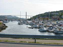 View of Rørvik | |||
| |||
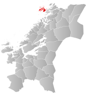 Vikna within Trøndelag | |||
| Coordinates: 64°54′42″N 11°01′55″E / 64.91167°N 11.03194°ECoordinates: 64°54′42″N 11°01′55″E / 64.91167°N 11.03194°E | |||
| Country | Norway | ||
| County | Trøndelag | ||
| District | Namdalen | ||
| Established | 1 July 1869 | ||
| Administrative centre | Rørvik | ||
| Government | |||
| • Mayor (2015) | Amund Hellesø (AP) | ||
| Area | |||
| • Total | 318.69 km2 (123.05 sq mi) | ||
| • Land | 311.17 km2 (120.14 sq mi) | ||
| • Water | 7.52 km2 (2.90 sq mi) 2.4% | ||
| Area rank | #269 in Norway | ||
| Population (2017) | |||
| • Total | 4,418 | ||
| • Rank | #223 in Norway | ||
| • Density | 14.2/km2 (37/sq mi) | ||
| • Change (10 years) | 9.9% | ||
| Demonym(s) | Viknværing[1] | ||
| Time zone | UTC+01:00 (CET) | ||
| • Summer (DST) | UTC+02:00 (CEST) | ||
| ISO 3166 code | NO-5050 | ||
| Official language form | Neutral | ||
| Website |
vikna | ||


Vikna is a municipality in Trøndelag county, Norway. It is part of the Namdalen region. The administrative centre of the municipality is the village of Rørvik. Other villages in Vikna include Austafjord, Garstad, and Valøya.

The 319-square-kilometre (123 sq mi) municipality is the 269th largest by area out of the 422 municipalities in Norway. Vikna is the 223rd most populous municipality in Norway with a population of 4,418. The municipality's population density is 14.2 inhabitants per square kilometre (37/sq mi) and its population has increased by 9.9% over the last decade.[2]
General information
The municipality of Vikten was established on 1 July 1869 when it was separated from the large municipality of Nærøy. Initially, the population of Vikten was 1,749. On 1 January 1881, a small area of Fosnes (population: 61) was transferred to Vikten. The name of the municipality was later changed to Vikna.[3]
On 8 June 2017, the Norwegian Parliament, the Storting, voted to merge the municipalities of Leka, Vikna, Nærøy, and Bindal to form one, large municipality effective 1 January 2020.[4] Leka and Bindal municipalities rejected the merger, but Vikna and Nærøy will merge on that date to form the new municipality of Nærøysund.[5]
On 1 January 2018, the municipality switched from the old Nord-Trøndelag county to the new Trøndelag county.
Name
The municipality is named after the three large islands in the municipality: Inner-Vikna, Mellom-Vikna, and Ytter-Vikna (Old Norse: Víkn). The name is derived from the word vík which means "cove" or "wick". (The islands are scored by numerous coves and inlets.)[6]
Coat of arms
The coat of arms is from modern times; they were granted on 13 May 1988. The arms show three salmon on a blue background. This was chosen because salmon fishing and farming was (and still is) an important source of income in the municipality.[7]
Churches
The Church of Norway has one parish (sokn) within the municipality of Vikna. It is part of the Namdal prosti (deanery) in the Diocese of Nidaros.
| Parish (Sokn) | Church Name | Location of the Church | Year Built |
|---|---|---|---|
| Vikna | Garstad Church | Garstad | 1856 |
| Rørvik Church | Rørvik | 1896 | |
| Valøy Chapel | Valøya | 1972 |
Geography
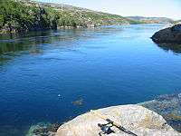
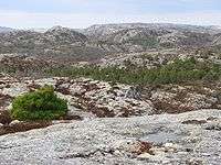
The municipality consists of a large island archipelago with some 6,000 large and small islands going far into the Norwegian Sea off the northwestern coast of Trøndelag county. Vikna is the largest spawning area for cod south of Lofoten. The three largest islands are: Inner-Vikna, closest to the mainland, Mellom-Vikna, and then Ytter-Vikna as the westernmost island. Other islands include Borgan and Lauvøya.
The main village is Rørvik, located on the eastern shore of Inner-Vikna, facing the mainland across the Nærøysundet strait. The many islands in the area means that there are many lighthouses including Gjeslingene Lighthouse, Grinna Lighthouse, Nærøysund Lighthouse, and Nordøyan Lighthouse.
On 21 October 1962, the coastal steamer (Hurtigruten) Sanct Svithun run aground on Nordøyan as a result of navigational error. The ship sunk, and there was a tragic loss of 41 lives. A memorial bauta was raised on Nordøyan in 2002.
Government
All municipalities in Norway, including Vikna, are responsible for primary education (through 10th grade), outpatient health services, senior citizen services, unemployment and other social services, zoning, economic development, and municipal roads. The municipality is governed by a municipal council of elected representatives, which in turn elect a mayor. The municipality falls under the Namdal District Court and the Frostating Court of Appeal.
Municipal council
The municipal council (Kommunestyre) of Vikna is made up of 23 representatives that are elected to four year terms. Currently, the party breakdown is as follows:[8]
| Party Name | Name in Norwegian | Number of representatives | |
|---|---|---|---|
| Labour Party | Arbeiderpartiet | 8 | |
| Progress Party | Fremskrittspartiet | 2 | |
| Conservative Party | Høyre | 1 | |
| Christian Democratic Party | Kristelig Folkeparti | 1 | |
| Centre Party | Senterpartiet | 3 | |
| Socialist Left Party | Sosialistisk Venstreparti | 1 | |
| Liberal Party | Venstre | 7 | |
| Total number of members: | 23 | ||
Economy
Fishing, fish farming, public services, and agriculture are the main sources of income. The Norveg museum, devoted to the coastal way of life through the centuries, is located in Rørvik. The Vikna Wind Farm is located on Mellom-Vikna, just west of Garstad, and it produces power for much of the municipality.
Transportation
Hurtigruten boats stop frequently at Rørvik and Norwegian County Road 770 via the Nærøysund Bridge connects Vikna to the mainland and European route E6. There is also the small Rørvik Airport, Ryum, just south of Rørvik. Vikna and neighbouring Nærøy form a common work area with nearly 10,000 inhabitants.
References
- ↑ "Navn på steder og personer: Innbyggjarnamn" (in Norwegian). Språkrådet. Retrieved 2015-12-01.
- ↑ Statistisk sentralbyrå (2017). "Table: 06913: Population 1 January and population changes during the calendar year (M)" (in Norwegian). Retrieved 2017-09-26.
- ↑ Jukvam, Dag (1999). "Historisk oversikt over endringer i kommune- og fylkesinndelingen" (PDF) (in Norwegian). Statistisk sentralbyrå.
- ↑ "Kommunesammenslåing Nærøy, Vikna, Leka, og Bindal" (PDF) (in Norwegian). Leka kommune. 2017-08-21. Retrieved 2017-09-26.
- ↑ "Navn på ny kommune" (in Norwegian). Vikna kommune. 2018-02-05. Retrieved 2018-04-29.
- ↑ Rygh, Oluf (1903). Norske gaardnavne: Nordre Trondhjems amt (dokpro.uio.no) (in Norwegian) (15 ed.). Kristiania, Norge: W. C. Fabritius & sønners bogtrikkeri. p. 359.
- ↑ "Civic heraldry of Norway - Norske Kommunevåpen". Heraldry of the World. Retrieved 2018-05-05.
- ↑ "Table: 04813: Members of the local councils, by party/electoral list at the Municipal Council election (M)" (in Norwegian). Statistics Norway. 2015.
External links
| Wikimedia Commons has media related to Vikna. |

- Municipal fact sheet from Statistics Norway (in Norwegian)
- Norveg Museum
- Cultural map of Vikna (in Norwegian)
- The plant cover of Kalvøya island
| |||||||
| |||||||
| |||||||
