Røros
| Røros kommune Plassje | |||
|---|---|---|---|
| Municipality | |||
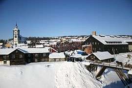 View of the mining town of Røros | |||
| |||
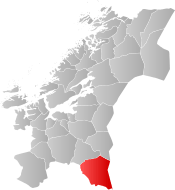 Røros within Trøndelag | |||
| Coordinates: 62°34′27″N 11°22′59″E / 62.57417°N 11.38306°ECoordinates: 62°34′27″N 11°22′59″E / 62.57417°N 11.38306°E | |||
| Country | Norway | ||
| County | Trøndelag | ||
| District | Gauldal | ||
| Established | 1 Jan 1838 | ||
| Administrative centre | Røros | ||
| Government | |||
| • Mayor (2007) | Hans Vintervold (Ap) | ||
| Area | |||
| • Total | 1,956.46 km2 (755.39 sq mi) | ||
| • Land | 1,756.21 km2 (678.08 sq mi) | ||
| • Water | 200.25 km2 (77.32 sq mi) 10.2% | ||
| Area rank | #32 in Norway | ||
| Population (2017) | |||
| • Total | 5,623 | ||
| • Rank | #187 in Norway | ||
| • Density | 3.2/km2 (8/sq mi) | ||
| • Change (10 years) | -0.8% | ||
| Demonym(s) | Rørosing[1] | ||
| Time zone | UTC+01:00 (CET) | ||
| • Summer (DST) | UTC+02:00 (CEST) | ||
| ISO 3166 code | NO-5025 | ||
| Official language form | Neutral | ||
| Website |
roros | ||


| UNESCO World Heritage site | |
|---|---|
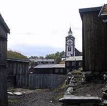 The old Røros in front of the church | |
| Criteria | Cultural: iii, iv, v |
| Reference | 55 |
| Inscription | 1980 (4th Session) |
| Extensions | 2010 |
| Area | 16,510 ha |
| Buffer zone | 481,240 ha |
![]()
The mining town of Røros (the administrative centre of the municipality) is sometimes called Bergstaden which means "mountain town" due to its historical notoriety for copper mining. It is one of two towns in Norway that were historically designated "mining towns", along with the "silver-town" of Kongsberg. The modern-day inhabitants of Røros still work and live in the characteristic 17th and 18th century buildings which have led to its designation as a UNESCO World Heritage Site in 1980. Røros has about 80 wooden houses, most of them standing around courtyards. Many retain their dark pitch-log facades, giving the town a medieval appearance.[2]
The 1,956-square-kilometre (755 sq mi) municipality is the 32nd largest by area out of the 422 municipalities in Norway. Røros is the 187th most populous municipality in Norway with a population of 5,623. The municipality's population density is 3.2 inhabitants per square kilometre (8.3/sq mi) and its population has decreased by 0.8% over the last decade.[3]
General information
The parish of Røros was established as a municipality on 1 January 1838 (see formannskapsdistrikt). On 1 January 1875, an unpopulated area of the neighboring municipality of Ålen was transferred to Røros. On 1 January 1926, Røros was split into four municipalities: Røros landsogn (population: 701), Brekken (population: 1,098), Glåmos (population: 983), and the town of Røros (population: 2,284). During the 1960s, there were many municipal mergers across Norway due to the work of the Schei Committee. On 1 January 1964, the four municipalities of Glåmos (population: 700), Brekken (population: 964), Røros landsogn (population: 482), and the town of Røros (population: 3,063) were all reunited under the name Røros. On 21 April 1989, an unpopulated part of Røros was transferred to Holtålen.[4] On 1 January 2018, the municipality switched from the old Sør-Trøndelag county to the new Trøndelag county.
Name
The municipality (and town) is named after the old Røros farm ("Røraas" around 1530), since the town was built on its ground. The first element is the river name Røa and the last element is os meaning "mouth of a river" (the small river Røa runs into the great river Glåma here). The meaning of the river name Røa is unknown.[5] There is no available interpretation of the Southern Sami name, Plassje.
Coat of arms
The coat of arms is from modern times, they were adopted on 29 October 1992. The arms show an old copper symbol above two crossed mining tools in yellow on a red background.[6]
Churches
The Church of Norway has four parishes (sokn) within the municipality of Røros. It is part of the Gauldal prosti (deanery) in the Diocese of Nidaros.
| Parish (Sokn) | Church Name | Location of the Church | Year Built |
|---|---|---|---|
| Røros | Røros Church | Røros | 1784 |
| Røros Chapel | Røros | 1962 | |
| Brekken | Brekken Church | Brekken | 1878 |
| Glåmos | Glåmos Church | Glåmos | 1926 |
| Hitterdalen | Hitterdal Chapel | Hitterdalen | 1959 |
History
Røros municipality has historically been used by the Southern Sami people for reindeer herding. Known for its copper mines, Røros is one of Norway's two nationally significant mining towns with activity starting in the 17th century (the other one being the "silver-town" Kongsberg, see Kongsberg Silver Mines).
Røros was burned to the ground in 1678 and 1679 by the Swedish Army during the Scanian War. In 1718, during the Great Northern War, the town was once again taken by the Swedish Army, led by General De la Barre, who made up the southern arm of the main Swedish Army under Carl Gustaf Armfeldt. De la Barre took the city and all their mined copper at gunpoint.
When King Carl XII was killed near Fredriksten on 30 November 1718, De la Barre retreated north to join the bulk of the army. However, this ended in tragedy, when over 3,000 rather unprepared soldiers perished in the harsh weather conditions in the mountains northwest of Røros.
Røros and its people were made famous to Norwegians at the turn of the 20th century by semi-fictional author Johan Falkberget, who told the story of the mining community from the perspective of the hard-tested miners at the bottom of the social ladder.
With its authentic wooden buildings, Røros was added to the UNESCO World Heritage Site list in 1980.[7]
Røros Copper Works
In 1644, the general manager of the mine at Kongsberg gave permission to exploit one lode of copper in the mountains near Rauhaammaaren. Storvola and Gamle Storwartz became some of the company’s most important mines. Nordgruve, another important mining area, was situated to the north east of Røros.
Starting in 1740 and onwards was a period of greatness for the Røros Copper Works with several mines yielding well. Dynamite was utilized from 1870 and later drilling machines. The electrical generating station built high-tension power lines to supply the mines starting in 1897. The Bessemer process was introduced at the end of the 1800s. The Rørosbanen railway line was completed in 1877. High prices for both copper and zinc gave good results, but then the prices dropped and there were several years with large losses. After 333 years, mining activity in Røros ceased in 1977.[8]
Culture
During winter, a traditional market called "Rørosmartnan" is organized and that draws an average of 60,000–70,000 tourists to the town of Røros each year. The market begins on the last Tuesday in February and lasts five days.[9] There is also an outdoor musical theatre performance played in Røros to commemorate the tragedy when the Swedish soldiers froze to death. This show has been played since 1994.[10]
Media
The newspapers Arbeidets Rett and Fjell-Ljom are published in Røros.
Government
All municipalities in Norway, including Røros, are responsible for primary education (through 10th grade), outpatient health services, senior citizen services, unemployment and other social services, zoning, economic development, and municipal roads. The municipality is governed by a municipal council of elected representatives, which in turn elect a mayor. The municipality falls under the Sør-Trøndelag District Court and the Frostating Court of Appeal.
Municipal council
The municipal council (Kommunestyre) of Røros is made up of 27 representatives that are elected to four year terms. Currently, the party breakdown is as follows:[11]
| Party Name | Name in Norwegian | Number of representatives | |
|---|---|---|---|
| Labour Party | Arbeiderpartiet | 11 | |
| Conservative Party | Høyre | 5 | |
| Centre Party | Senterpartiet | 3 | |
| Socialist Left Party | Sosialistisk Venstreparti | 4 | |
| Liberal Party | Venstre | 2 | |
| Local Lists | Lokale lister | 2 | |
| Total number of members: | 27 | ||
Geography

Røros is located on a gently sloping plateau about 630 metres (2,070 ft) above sea level that is forested with mostly birch and some pine, but the tree line is never far away. The largest lake within the municipality is Aursund and the river Glåma has its origin here. The most northerly part of Femund, the third largest lake in Norway, is located in Røros, just west of Femundsmarka National Park. These lakes and others in Røros, such as Bolagen and Flensjøen, are well suited for kayaking and fishing. Other lakes include Feragen, Håsjøen, Rambergsjøen, Korssjøen, Nedre Roasten, Rogen, and Rien.
Climate
Røros has a subarctic climate. Mostly sheltered from oceanic influences, and located at ca 650 m amsl, Røros has recorded the coldest temperatures in the southern half of Norway with −50.3 °C (−58.5 °F) in early January 1914. In the European cold snap of January 2010 temperatures reached −42 °C (−44 °F). The heat record 30.7 °C (87.3 °F) was recorded July 2008. Skiing conditions in winter are usually excellent, with the period from February to April as the optimum, as the sun is higher and the days longer than earlier in winter. The largest snow depth recorded in Røros is 200 centimetres (79 in) in March 1956. In more recent years, 87 centimetres (34 in) snow on the ground was recorded in March 2009. Snow on the ground is virtually guaranteed in Røros from December to early April. Early May 1997 saw 76 cm snow on the ground (source: eklima/met.no).
Haugan, an unincorporated settlement situated 2 kilometres (1.2 mi) from Røros Airport, is the location of a weather station operated by the Norwegian Meteorologist institute. (Norwegian: Meteorologisk institutt).[12]
All the record lows are old, the most recent (December) from 1978, while 7 of the monthly records highs are from year 2000 and later.
| Climate data for Røros (625 m; 1981 - 2010; extremes 1900 - 2018) | |||||||||||||
|---|---|---|---|---|---|---|---|---|---|---|---|---|---|
| Month | Jan | Feb | Mar | Apr | May | Jun | Jul | Aug | Sep | Oct | Nov | Dec | Year |
| Record high °C (°F) | 10.4 (50.7) |
10.8 (51.4) |
14.5 (58.1) |
19 (66) |
26.7 (80.1) |
29.5 (85.1) |
30.7 (87.3) |
29.8 (85.6) |
25.7 (78.3) |
21.2 (70.2) |
11.8 (53.2) |
7.6 (45.7) |
30.7 (87.3) |
| Average high °C (°F) | −4.9 (23.2) |
−3.6 (25.5) |
0.3 (32.5) |
4.8 (40.6) |
11 (52) |
15.2 (59.4) |
18.1 (64.6) |
16.4 (61.5) |
11.4 (52.5) |
5.1 (41.2) |
−1 (30) |
−4.8 (23.4) |
5.7 (42.2) |
| Daily mean °C (°F) | −9.6 (14.7) |
−8.8 (16.2) |
−4.8 (23.4) |
0.3 (32.5) |
5.8 (42.4) |
9.9 (49.8) |
12.7 (54.9) |
11.4 (52.5) |
7.1 (44.8) |
1.7 (35.1) |
−4.5 (23.9) |
−9.4 (15.1) |
1 (33.8) |
| Average low °C (°F) | −14.4 (6.1) |
−13.9 (7) |
−9.9 (14.2) |
−4.2 (24.4) |
0.6 (33.1) |
4.5 (40.1) |
7.2 (45) |
6.4 (43.5) |
2.6 (36.7) |
−1.8 (28.8) |
−8 (18) |
−14 (7) |
−3.7 (25.3) |
| Record low °C (°F) | −50.3 (−58.5) |
−43.5 (−46.3) |
−41 (−42) |
−32.3 (−26.1) |
−18.9 (−2) |
−5.6 (21.9) |
−3.4 (25.9) |
−4.9 (23.2) |
−11.3 (11.7) |
−28.4 (−19.1) |
−36.4 (−33.5) |
−44 (−47) |
−50.3 (−58.5) |
| Average precipitation mm (inches) | 39.3 (1.547) |
32 (1.26) |
25.9 (1.02) |
24.7 (0.972) |
33.6 (1.323) |
58.6 (2.307) |
75.8 (2.984) |
74.3 (2.925) |
50.8 (2) |
37.8 (1.488) |
36.4 (1.433) |
35 (1.38) |
524.2 (20.639) |
| Average precipitation days (≥ 1.0 mm) | 10 | 8 | 8 | 7 | 7 | 11 | 12 | 13 | 10 | 9 | 9 | 10 | 114 |
| Source #1: Meteo climat stats | |||||||||||||
| Source #2: met.no/eklima | |||||||||||||
Transportation
The municipality is served by the Rørosbanen railway line at Røros Station. Røros Airport has a scheduled service to Oslo. The Norwegian County Road 30 connects Røros to the south to Tynset and northwest down the Gaula valley towards Trondheim. There is also the Norwegian County Road 705 going north to Selbu and Stjørdal, and the Norwegian County Road 31 going east to Sweden.
Media gallery
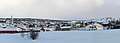 Overview Røros
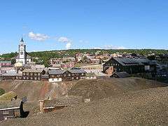 Røros in summer
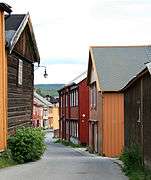 Finneveta, one of the narrow old streets in Røros
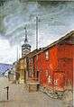 Fra Røros (Lillegaten), oil painting by Harald Sohlberg from 1902 (titled from Røros (side street))
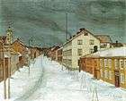 Storgaten Røros, painting by Harald Sohlberg from 1903 (titled Røros main street)
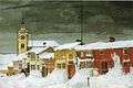 Efter snestorm, Lillegaten Røros, oil painting by Harald Sohlbeg from 1904 (titled After the snowstorm, Røros sidestreet)
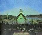 Natt painting by Harald Sohlberg from 1904 (titled Night)
References
- ↑ "Navn på steder og personer: Innbyggjarnamn" (in Norwegian). Språkrådet. Retrieved 2015-12-01.
- ↑ "Røros - the mining town". Hurtigruten.us. Archived from the original on 2011-02-07. Retrieved 2011-02-28.
- ↑ Statistisk sentralbyrå (2017). "Table: 06913: Population 1 January and population changes during the calendar year (M)" (in Norwegian). Retrieved 2017-10-07.
- ↑ Jukvam, Dag (1999). "Historisk oversikt over endringer i kommune- og fylkesinndelingen" (PDF) (in Norwegian). Statistisk sentralbyrå.
- ↑ Rygh, Oluf (1901). Norske gaardnavne: Søndre Trondhjems amt (in Norwegian) (14 ed.). Kristiania, Norge: W. C. Fabritius & sønners bogtrikkeri. p. 199.
- ↑ "Begrunnelse valg av kommunevåpen" (in Norwegian). Røros kommune. Retrieved 2011-02-25.
- ↑ "The People and the Farms". The Røros World Heritage Site.
- ↑ "The Røros Copper Works". The Røros World Heritage Site.
- ↑ "Rørosmartnan". Retrieved 2011-02-25.
- ↑ "Et historisk musikkteater på Røros" (in Norwegian). Retrieved 2008-10-28.
- ↑ "Table: 04813: Members of the local councils, by party/electoral list at the Municipal Council election (M)" (in Norwegian). Statistics Norway. 2015.
- ↑ Weather forecast for Haugan in Røros
External links
| Wikimedia Commons has media related to Røros. |
| Wikivoyage has a travel guide for Røros. |
- Municipal fact sheet from Statistics Norway (in Norwegian)
- History of Røros at Bergstaden.Org (in Norwegian)
- World heritage site Røros
- Røros info (in Norwegian)
- UNESCO Røros entry
- Visitnorway.com Røros
- Map hiking and DNT cabins
- VR images of Røros
- Haugan, Røros, Norway
| |||||||
| |||||||
| |||||||

| Northern |
| |
|---|---|---|
| Trøndelag |
| |
| Western |
| |
| Eastern | ||
1 Shared with nine other countries | ||
| Authority control |
|---|