Høylandet
| Høylandet kommune | |||
|---|---|---|---|
| Municipality | |||
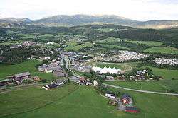 View of Høylandet village | |||
| |||
 Høylandet within Trøndelag | |||
| Coordinates: 64°43′27″N 12°20′02″E / 64.72417°N 12.33389°ECoordinates: 64°43′27″N 12°20′02″E / 64.72417°N 12.33389°E | |||
| Country | Norway | ||
| County | Trøndelag | ||
| District | Namdalen | ||
| Established | 1 Jan 1901 | ||
| Administrative centre | Høylandet | ||
| Government | |||
| • Mayor (2011) | Hege Nordheim-Viken (Sp) | ||
| Area | |||
| • Total | 754.68 km2 (291.38 sq mi) | ||
| • Land | 702.64 km2 (271.29 sq mi) | ||
| • Water | 52.04 km2 (20.09 sq mi) 6.9% | ||
| Area rank | #146 in Norway | ||
| Population (2017) | |||
| • Total | 1,264 | ||
| • Rank | #372 in Norway | ||
| • Density | 1.8/km2 (5/sq mi) | ||
| • Change (10 years) | -0.2% | ||
| Demonym(s) | Hålling[1] | ||
| Time zone | UTC+01:00 (CET) | ||
| • Summer (DST) | UTC+02:00 (CEST) | ||
| ISO 3166 code | NO-5046 | ||
| Official language form | Neutral | ||
| Website |
hoylandet | ||


Høylandet is a municipality in Trøndelag county, Norway. It is part of the Namdalen region. The administrative centre of the municipality is the village of Høylandet. Other villages include Kongsmoen and Vassbotna.
The 755-square-kilometre (292 sq mi) municipality is the 146th largest by area out of the 422 municipalities in Norway. Høylandet is the 372nd most populous municipality in Norway with a population of 1,264. The municipality's population density is 1.8 inhabitants per square kilometre (4.7/sq mi) and its population has decreased by 0.2% over the last decade.[2]
General information
The municipality of Høylandet was established on 1 January 1901 when it was separated from the large municipality of Grong. Initially, the population of Høylandet was 1,046. During the 1960s, there were many municipal mergers across Norway due to the work of the Schei Committee. On 1 January 1964, the Kongsmoen area (population: 221) of eastern Foldereid municipality was merged into Høylandet. On that same date the Galguften and Hauknes areas (population: 15) were transferred from Høylandet to neighboring Overhalla municipality.[3] On 1 January 2018, the municipality switched from the old Nord-Trøndelag county to the new Trøndelag county.
Name
The Old Norse form of the name was Høylandir. The first element is høy which means "hay" and the last element is the plural form of land which means "land" or "region". The name was historically spelled Hølandet.[4]
Coat of arms
The coat of arms is from modern times; they were granted on 2 January 1990. The arms show a black and white whooper swan (Cygnus cygnus) on a green background. This was chosen because of the large number of these swans that migrate through the area each year.[5][6]
Churches
The Church of Norway has one parish (sokn) within the municipality of Høylandet. It is part of the Namdal prosti (deanery) in the Diocese of Nidaros.
| Parish (Sokn) | Church Name | Location of the Church | Year Built |
|---|---|---|---|
| Høylandet | Drageid Church | Vassbotna | 1976 |
| Høylandet Church | Høylandet | 1860 | |
| Kongsmo Chapel | Kongsmoen | 1937 |
Geography
There are several large lakes in Høylandet including Almåsgrønningen, Eidsvatnet, Grungstadvatnet, Øyvatnet, and Storgrønningen. The innermost part of the Foldafjord is located in northern Høylandet. Norwegian County Road 17 runs through the municipality from south to north through the central valley.
Government
All municipalities in Norway, including Høylandet, are responsible for primary education (through 10th grade), outpatient health services, senior citizen services, unemployment and other social services, zoning, economic development, and municipal roads. The municipality is governed by a municipal council of elected representatives, which in turn elect a mayor. The municipality falls under the Namdal District Court and the Frostating Court of Appeal.
Municipal council
The municipal council (Kommunestyre) of Høylandet is made up of 19 representatives that are elected to four year terms. Currently, the party breakdown is as follows:[7]
| Party Name | Name in Norwegian | Number of representatives | |
|---|---|---|---|
| Labour Party | Arbeiderpartiet | 5 | |
| Centre Party | Senterpartiet | 12 | |
| Liberal Party | Venstre | 1 | |
| Local Lists | Lokale lister | 1 | |
| Total number of members: | 19 | ||
References
- ↑ "Navn på steder og personer: Innbyggjarnamn" (in Norwegian). Språkrådet. Retrieved 2015-12-01.
- ↑ Statistisk sentralbyrå (2017). "Table: 06913: Population 1 January and population changes during the calendar year (M)" (in Norwegian). Retrieved 2017-09-26.
- ↑ Jukvam, Dag (1999). "Historisk oversikt over endringer i kommune- og fylkesinndelingen" (PDF) (in Norwegian). Statistisk sentralbyrå.
- ↑ Rygh, Oluf (1903). Norske gaardnavne: Nordre Trondhjems amt (dokpro.uio.no) (in Norwegian) (15 ed.). Kristiania, Norge: W. C. Fabritius & sønners bogtrikkeri. p. 267.
- ↑ Store norske leksikon. "Høylandet – kommune i Nord-Trøndelag" (in Norwegian). Retrieved 2011-09-21.
- ↑ "Civic heraldry of Norway - Norske Kommunevåpen". Heraldry of the World. Retrieved 2018-04-18.
- ↑ "Table: 04813: Members of the local councils, by party/electoral list at the Municipal Council election (M)" (in Norwegian). Statistics Norway. 2015.
External links
| Wikimedia Commons has media related to Høylandet. |

- Municipal fact sheet from Statistics Norway (in Norwegian)
| |||||||
| |||||||
| |||||||

| Authority control |
|---|